

June 13th widespread damaging winds & very large hail
Published 2026-06-15
June 10th severe storms including a brief tornado
Published 2026-06-12
March 5th Late Night Sumner County Tornadoes
Published 2026-05-21
May 18th 2026 Widespread Severe Storms
Published 2026-05-19
April 2026 Climate Summary and Highlights
Published 2026-05-02
Three rounds of storms including an EF-2 tornado on April 26th
Published 2026-04-28
Large hail impacts Wichita on April 25th
Published 2026-04-26
April 23rd Landspouts and Large Hail!
Published 2026-04-25
April 11th Damaging Supercell
Published 2026-04-12
March 15th 2026 intense northwest winds!
Published 2026-03-16
Severe Weather Preparedness - March 2-6, 2026
Published 2026-02-24
January 23rd - 25th long duration snow storm & Arctic cold
Published 2026-01-28
First widespread snow of the season!
Published 2026-01-10
December 18th 2025 very strong winds and grass fires
Published 2025-12-22
November 10th 2025 Rare Kansas Aurora Event
Published 2025-11-14
September 8th Central Kansas Flash Flooding
Published 2025-09-09
Very Large Hail on September 3rd!
Published 2025-09-04
June 17th afternoon and evening flooding and severe storms
Published 2025-06-21
Bow echo produces strongest winds ever recorded in Wichita!
Published 2025-06-20
April 22nd Large Hail Event!
Published 2025-04-23
April 1st Severe Storms Including Tornadoes
Published 2025-04-02
March 14th Extremely Strong Winds...
Published 2025-03-22
March 4th extremely strong northwest winds!
Published 2025-03-07
2nd Snow Storm In 6 Days Impacts Kansas
Published 2025-01-10
January 4th-5th Blizzard & Ice
Published 2025-01-06
NOAA's 2024-25 Winter Outlook
Published 2024-10-17
United States winter outlook issued by the Climate Prediction Center.
Soliciting Comments for the Discontinuation of the Max/Min Temperature and Precipitation Table Product (RTP)
Published 2024-10-03
August 16th Flint Hills Supercells!
Published 2024-08-19
July 31st Damaging Storms with Wind in Central Kansas
Published 2024-08-03
Damaging thunderstorms winds moved across north central Kansas during the evening of July 31st.
July 16th early morning intense straight-line winds!
Published 2024-07-16
July 3rd late night damaging winds
Published 2024-07-04
July 2nd damaging straight-line winds
Published 2024-07-04
June 4th hail and high winds
Published 2024-06-06
May 25th widespread severe storms including Harper County EF-2
Published 2024-05-27
May 19th Derecho and HP Supercell
Published 2024-05-22
May 6th widespread severe storms
Published 2024-05-08
April 16th 2024 Greenwood county early morning tornadoes
Published 2024-04-17
Our latest Spotter Newsletter is now available!
Published 2024-03-26
Spring Flood Outlook #3
Published 2024-03-14
January 2024 extreme cold!
Published 2024-01-17
November 25th - Rare November snow storm!
Published 2023-11-28
NWS Testing of a New River Observation and Forecast Website
Published 2023-11-16
Halloween Climatology
Published 2023-10-30
Feedback Requested: Experimental Graphical Drought Information Statement
Published 2023-09-18
Record Breaking August 2023 Heat
Published 2023-08-24
Two rounds of damaging winds on Aug 5th and 6th
Published 2023-08-08
Looking for a Weather Observer near Cassoday Kansas!
Published 2023-08-08
July 16th 2023 destructive supercell thunderstorm
Published 2023-07-18
July 14th 2023 line of severe storms
Published 2023-07-18
June 17th 2023 Severe Straight-line Winds
Published 2023-06-20
Seeking comments on the NWS “Advisory†and “Special Weather Statements†headlines being replaced by plain language headlines.
Published 2023-05-17
This new plain language product will be in a bulleted “What, Where, When, Impacts†format and equipped with computer-readable Valid Time Event Code (VTEC)
April 19th 2023 Marion & Chase county tornadic supercell
Published 2023-04-21
March 31st 2023 strong winds and critical fire weather conditions
Published 2023-04-01
January 21st 2023 West-Central Kansas Heavy Snow
Published 2023-01-22
Arctic air and white-out conditions invade the region on the morning of Dec 22, 2022
Published 2022-12-29
Submit a Drought Report for Your Location
Published 2022-10-22
Submit a drought report for your location.
Historically Hot and Dry September 2022
Published 2022-09-23
June 23rd 2022 long-lived supercell & tornadoes
Published 2022-06-24
May 31st 2022 severe storms and flooding
Published 2022-06-02
April 29th 2022 Tornadoes - including the Andover Tornado
Published 2022-05-01
Rare late March snow event - March 31st
Published 2022-04-01
March 9th-10th 2022 northern Kansas heavy snow band...
Published 2022-03-15
Get ready for spring weather hazards by visiting our Spring Safety website!
Published 2022-03-01
February 17th 2022 Snow Storm
Published 2022-02-18
Arctic airmass and snow on January 5th & 6th
Published 2022-01-07
Get ready for winter weather hazards by visiting our Winter Safety website!
Published 2021-12-31
October 28th 2021 intense northwest winds
Published 2021-10-29
Real Time NOAA Weather Radio Audio Files
Published 2021-09-09
New Climate Webpage Design
Published 2021-08-27
Supercell thunderstorm produces damage across Rice County on August 15th
Published 2021-08-17
Damaging winds, heavy rain and flooding on June 25th
Published 2021-06-27
New 1991-2020 Climate Normals Released
Published 2021-05-04
Rare Spring snow storm affected Northern and Central Kansas
Published 2021-04-20
March 29th 2021 strong winds and grass fires
Published 2021-03-31
January 14th and 15th widespread strong winds
Published 2021-01-17
Proposal for soliciting comments on the discontinuance of certain short-fused NWS warning update statements
Published 2020-12-09
Please Take Our Short Survey About Frost and Freeze Products Issued by the National Weather Service
Published 2020-11-14
Rare October winter snow and ice storm
Published 2020-10-29
Check out the latest snowfall reports
Published 2020-10-26
October 11th 2020 extremely strong winds
Published 2020-10-12
Record cold September Airmass
Published 2020-09-10
Get ready for Fall weather hazards by visiting our Fall Safety website!
Published 2020-08-01
Should advisories go away? Here is the latest proposal.
Published 2020-07-29
Severe Thunderstorms on July 11 across southeast Kansas
Published 2020-07-13
Extreme instability developed across the region on July 11 with MLCape values exceeding 6000 J/KG. This extreme instability was paired with anomalously strong mid and upper level NW flow resulting in severe storms that produced very large hail, some exceeding 3 inches in diameter and numerous reports of damaging winds across southeast Kansas on the afternoon and evening of July 11, 2020.
June 21, 2020 Damaging Wind and Large Hail
Published 2020-06-22
A higher end severe weather event impacts portions of central and south-central Kansas during the afternoon and early evening hours of June 21, 2020. Notable reports include widespread wind damage across the town of Great Bend, wind gusts to 80 mph, as well as hail up to around baseball size.
June 9-10, 2020 High Wind Event
Published 2020-06-14
A rare high wind event, by June's standards, impacted portions of central and south-central Kansas June 9-10, 2020. High wind events aren't unheard of in June, but they are typically associated with thunderstorms. What made this event more rare is that it was not associated with any thunderstorm activity. It was driven by an unusually strong upper level storm system for the time of year.
May 15th heavy rain & flooding
Published 2020-05-16
Very slow start to severe weather season across Kansas...
Published 2020-05-02
April 11th very large hail!
Published 2020-04-12
Weather Experiments for Kids!
Published 2020-04-08
Looking for virtual learning activities? Check out these from the NWS and NOAA
Published 2020-03-24
Narrow band of intense snow on February 25th...
Published 2020-02-26
Severe Weather Awareness Week 2020
Published 2020-02-22
2019 Climate Review
Published 2020-01-03
December 15-16, 2019 Winter Storm Summary
Published 2019-12-17
New river forecast services for Slate Creek at Wellington
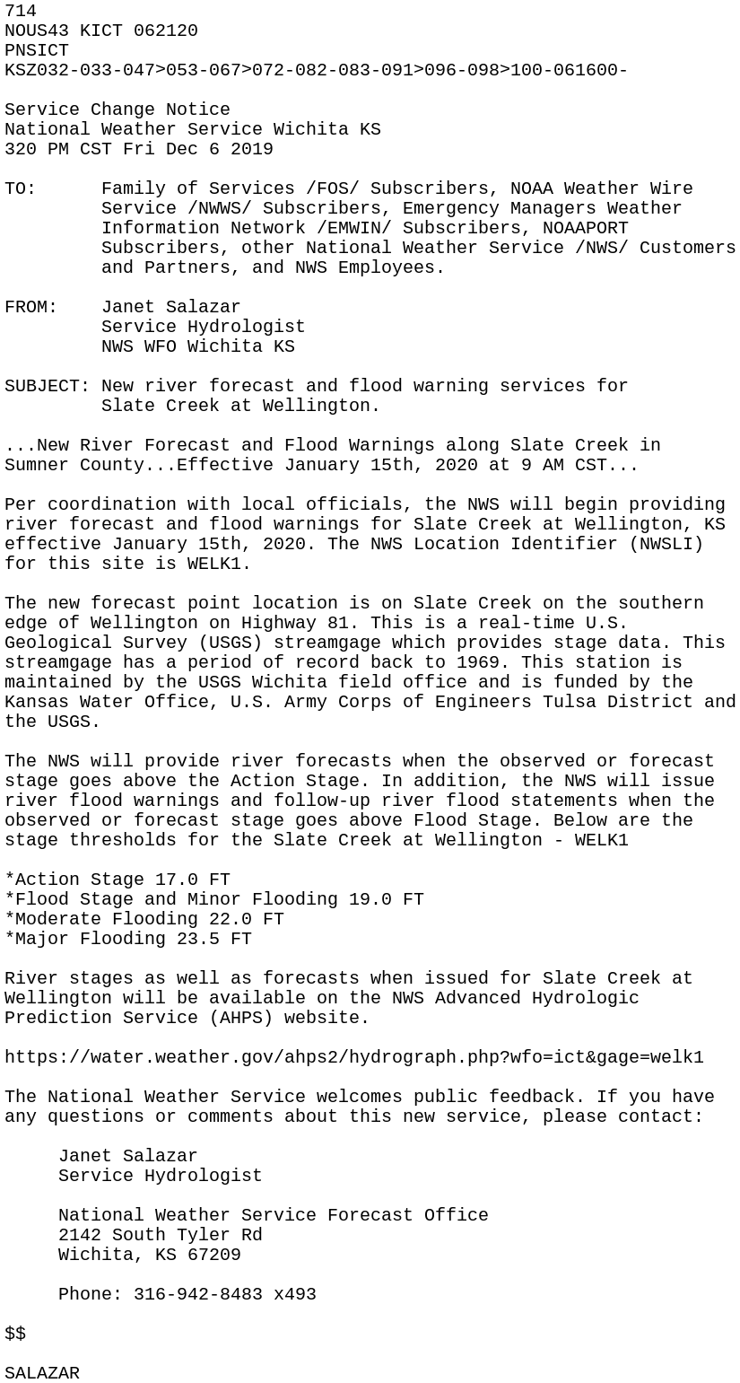
Published 2019-12-06
Get ready for winter weather hazards by visiting our Winter Safety website!
Published 2019-12-01
Historic November cold snap!
Published 2019-11-15
Our graphical hazardous weather outlook is changing!
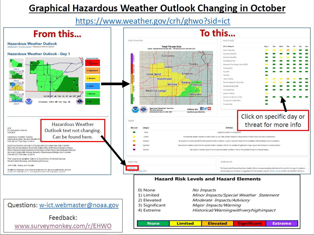
Published 2019-10-03
Second warmest September on record!
Published 2019-10-02
August 21st straight-line winds blow through Wichita area
Published 2019-08-26
August 18th 2019 train derailment
Published 2019-08-26
August 17th 2019 early morning heat burst!
Published 2019-08-26
June 21st-22nd Peabody flash flooding
Published 2019-06-28
June 22nd & 23rd - two rounds of damaging storms...
Published 2019-06-24
June 18th severe storms & flooding...
Published 2019-06-20
Significant flooding across south central Kansas
Published 2019-05-08
A stalled frontal boundary was draped across the region on Tuesday ahead of an approaching storm system. Widespread showers and thunderstorms with very heavy rainfall developed across the area once again. These storms inundated areas that were already saturated resulting in widespread flooding across south central Kansas.
May 5th Tornadoes and Large Hail...
Published 2019-05-06
April 28th-29th overnight very large hail & damaging winds
Published 2019-04-30
April 17th - First severe weather episode of the 2019 storm season
Published 2019-04-19
Historic low pressure system affects the Plains!
Published 2019-03-15
Second blizzard of the winter season impacts central Kansas...
Published 2019-02-24
February 6th ice storm with widespread thunder...
Published 2019-02-08
Storms of 2018...
Published 2019-01-03
Save the Date: Wichita Aviation Symposium, February 9, 2019
Published 2018-12-21
2nd snow event in 7 days impacts Kansas
Published 2018-11-13
October 2018 one of wettest and snowiest on record...
Published 2018-11-01
October 5th - 9th heavy rain & widespread flooding
Published 2018-10-10
National Test of the Emergency Alert System (EAS) and Wireless Emergency Alerts (WEA) Wednesday, October 3, 2018
Published 2018-10-01
Major Flood Stage Change for Walnut River near El Dorado
Published 2018-08-20
August 14th deadly flash flooding...
Published 2018-08-15
July 30th Damaging winds across Cowley & Sumner counties...
Published 2018-08-02
June 26th EF-3 Eureka tornado...
Published 2018-06-27
May 29th very large hail...
Published 2018-05-30
Severe storms possible this afternoon...
Published 2018-04-30
The threat for severe storms will shift eastward into the Flint Hills and southeast Kansas this afternoon.
Stay Safe this Severe Weather Season!
Published 2018-03-07
2018 Spring Flood Outlook Number 2
Published 2018-03-01
Put this Winter into Perspective...Accumulated Winter Season Severity Index (AWSSI)
Published 2018-01-24
Compare this winter's severity with other winters with the Accumulated Winter Season Severity Index (AWSSI).
January 15th, 2018 Light Snow Event
Published 2018-01-21
Check Out Our New Climate Graphs & Tables!
Published 2017-12-09
Check out our new monthly and annual climate graphs and tables for Wichita, Salina and Chanute.