Overview
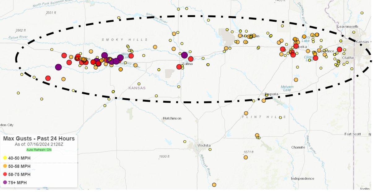
Cluster of storms migrated out of Western Kansas during the early morning hours of July 16th and strengthened as they approached Central Kansas. Storms produced intense straight-line winds as they tracked along I-70, with multiple reports of 70 to 90 mph winds. A Kansas Mesonet site north of Bunker Hill reported a 93 mph wind gust! Power poles were snapped in Russell County along with a couple campers rolled over southwest of Sylvan Grove.
Photos & Video
 |
|
 |
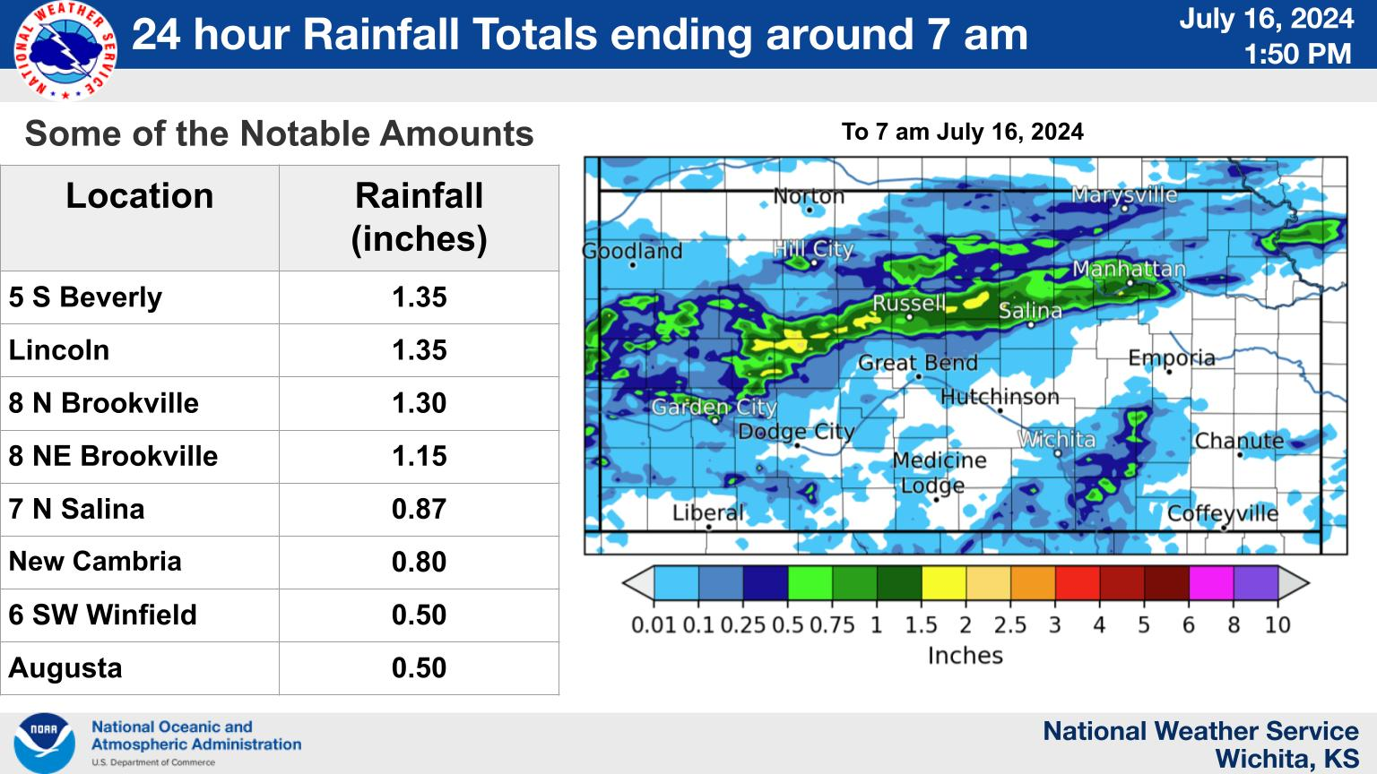
| Map showing strongest wind gusts from automated wind sensors across the state. | Rainfall from the early morning storms. You can see how they generally tracked along I-70. |
Storm reports
Preliminary Local Storm Report...Summary
National Weather Service Wichita KS
1008 AM CDT Tue Jul 16 2024

..TIME...   ...EVENT...      ...CITY LOCATION...     ...LAT.LON...
..DATE...   ....MAG....      ..COUNTY LOCATION..ST.. ...SOURCE....
            ..REMARKS..

0339 AM     Tstm Wnd Gst     4 W Russell             38.88N 98.93W
07/16/2024  M62 MPH          Russell            KS   Public


0340 AM     Tstm Wnd Gst     5 NNE Gorham            38.95N 99.00W
07/16/2024  M65 MPH          Russell            KS   Public


0341 AM     Tstm Wnd Gst     1 NE Russell Airport    38.87N 98.81W
07/16/2024  M58 MPH          Russell            KS   ASOS

            Corrects previous tstm wnd gst report from 1
            NE Russell Airport.

0346 AM     Tstm Wnd Gst     Russell Airport         38.87N 98.81W
07/16/2024  M76 MPH          Russell            KS   ASOS


0354 AM     Tstm Wnd Gst     Russell Airport         38.87N 98.81W
07/16/2024  M85 MPH          Russell            KS   ASOS


0408 AM     Tstm Wnd Dmg     6 SW Sylvan Grove       38.96N 98.49W
07/16/2024                   Russell            KS   911 Call Center

            Power poles snapped. Time based on radar.

0408 AM     Tstm Wnd Dmg     8 SW Sylvan Grove       38.94N 98.50W
07/16/2024                   Russell            KS   911 Call Center

            Two campers rolled over. Time based on
            radar.

0408 AM     Tstm Wnd Dmg     Russell                 38.89N 98.86W
07/16/2024                   Russell            KS   911 Call Center

            Power lines down and power poles snapped in
            Russell. Time estimated on radar.

0408 AM     Tstm Wnd Gst     3 NNE Bunker Hill       38.91N 98.68W
07/16/2024  M93 MPH          Russell            KS   Mesonet


0420 AM     Tstm Wnd Gst     7 SW Sylvan Grove       38.93N 98.49W
07/16/2024  M67 MPH          Russell            KS   Public


0428 AM     Tstm Wnd Gst     Lincoln                 39.04N 98.15W
07/16/2024  E70 MPH          Lincoln            KS   Trained Spotter


0433 AM     Tstm Wnd Gst     Lincoln                 39.04N 98.15W
07/16/2024  E80 MPH          Lincoln            KS   Trained Spotter


0501 AM     Tstm Wnd Gst     2 SW Salina             38.79N 97.65W
07/16/2024  M58 MPH          Saline             KS   ASOS


0517 AM     Tstm Wnd Gst     5 NNW New Cambria       38.95N 97.56W
07/16/2024  M79 MPH          Saline             KS   Mesonet

            Measured by a home weather station.
 |
Media use of NWS Web News Stories is encouraged! Please acknowledge the NWS as the source of any news information accessed from this site. |
 |