Overview
|
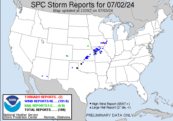
Storms rapidly developed over northern Oklahoma during the late afternoon hours on Tuesday July 2nd, and quickly tracked off to the northeast. These storms quickly started producing damaging straight-line winds as they moved into Harper and Kingman Counties with gusts of 60 to 65 mph reported. Line of severe storms moved across Wichita between 5 and 6 pm and produced widespread wind damage with numerous trees reported blown down. Winds across the city were measured between 60 and 70 mph. As the storms moved into Butler county, strong winds blew down a fireworks tent which resulted in 3 injuries. |
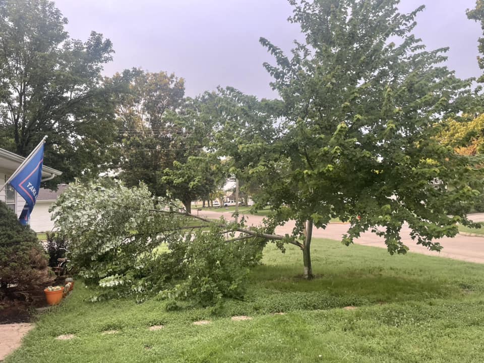 Image by Sam Scott via Facebook. Taken in Marion |
Photos & Video
|
|
|
|
|
|
|
|
|
Storm Reports
Preliminary Local Storm Report...Summary
National Weather Service Wichita KS
714 PM CDT Tue Jul 2 2024

..TIME...   ...EVENT...      ...CITY LOCATION...     ...LAT.LON...
..DATE...   ....MAG....      ..COUNTY LOCATION..ST.. ...SOURCE....
            ..REMARKS..

0439 PM     Tstm Wnd Gst     5 NW Harper             37.34N 98.09W
07/02/2024  E60 MPH          Harper             KS   Trained Spotter


0445 PM     Tstm Wnd Gst     5 NW Harper             37.34N 98.09W
07/02/2024  E65 MPH          Harper             KS   Trained Spotter


0520 PM     Tstm Wnd Gst     6 NNE Viola             37.57N 97.60W
07/02/2024  M67 MPH          Sedgwick           KS   Trained Spotter


0522 PM     Tstm Wnd Gst     1 W Andale              37.79N 97.65W
07/02/2024  M60 MPH          Sedgwick           KS   Mesonet


0532 PM     Tstm Wnd Gst     3 NW Wichita Eisenhower 37.69N 97.47W
07/02/2024  E65 MPH          Sedgwick           KS   Trained Spotter


0532 PM     Tstm Wnd Gst     1 SE Wichita Eisenhower 37.65N 97.43W
07/02/2024  M59 MPH          Sedgwick           KS   ASOS


0545 PM     Tstm Wnd Gst     1 SE Wichita Eisenhower 37.65N 97.43W
07/02/2024  M60 MPH          Sedgwick           KS   ASOS


0546 PM     Tstm Wnd Dmg     3 WNW Downtown Wichita  37.71N 97.39W
07/02/2024                   Sedgwick           KS   Public

            Large tree down on home near 13th and West.
            Report came in via social media.

0546 PM     Tstm Wnd Gst     1 NW Derby              37.56N 97.27W
07/02/2024  M68 MPH          Sedgwick           KS   Mesonet


0547 PM     Tstm Wnd Gst     Newton Airport          38.06N 97.28W
07/02/2024  M63 MPH          Harvey             KS   AWOS


0549 PM     Tstm Wnd Gst     2 NE East Wichita       37.71N 97.23W
07/02/2024  M67 MPH          Sedgwick           KS   Broadcast Media

            Reported by KAKE Broadcast media.

0550 PM     Tstm Wnd Dmg     4 SSE Maize             37.72N 97.44W
07/02/2024                   Sedgwick           KS   Public

            Tree blocking road near 21st and Tyler.

0550 PM     Tstm Wnd Dmg     3 SE Maize              37.74N 97.43W
07/02/2024                   Sedgwick           KS   Public

            Trees down. Report came in via social media.

0553 PM     Tstm Wnd Dmg     1 SSW Andover           37.68N 97.14W
07/02/2024                   Butler             KS   Broadcast Media

            *** 3 INJ ***
            Report of a fireworks tent blown over with 3
            injuries. Report was received via local TV.

0554 PM     Tstm Wnd Gst     Andover                 37.69N 97.14W
07/02/2024  E70 MPH          Butler             KS   Public


0555 PM     Tstm Wnd Dmg     1 NNW Downtown Wichita  37.70N 97.35W
07/02/2024                   Sedgwick           KS   Public

            Reported several large tree limbs down in
            Riverside Park.

0555 PM     Tstm Wnd Gst     2 W Whitewater          37.97N 97.19W
07/02/2024  M62 MPH          Harvey             KS   NWS Employee


0558 PM     Tstm Wnd Gst     3 ESE Bel Aire          37.75N 97.22W
07/02/2024  M63 MPH          Sedgwick           KS   AWOS

            AWOS station KAAO 2 ESE Bel Aire.

0558 PM     Tstm Wnd Gst     1 NNW Newton            38.05N 97.35W
07/02/2024  E65 MPH          Harvey             KS   Public


0559 PM     Tstm Wnd Gst     2 WSW Towanda           37.78N 97.03W
07/02/2024  M59 MPH          Butler             KS   Mesonet


0601 PM     Tstm Wnd Gst     1 ENE Whitewater        37.97N 97.13W
07/02/2024  M58 MPH          Butler             KS   Mesonet


0612 PM     Tstm Wnd Dmg     5 E Elbing              38.05N 97.03W
07/02/2024                   Butler             KS   Emergency Mngr

            2 inch diameter tree limbs down.

0612 PM     Tstm Wnd Dmg     Augusta                 37.69N 96.97W
07/02/2024                   Butler             KS   Emergency Mngr

            Reports of power lines down.

0619 PM     Tstm Wnd Gst     Burns                   38.09N 96.89W
07/02/2024  E70 MPH          Marion             KS   Emergency Mngr


0620 PM     Tstm Wnd Gst     5 ENE Peabody           38.20N 97.02W
07/02/2024  E60 MPH          Marion             KS   Emergency Mngr


0644 PM     Tstm Wnd Gst     3 SE Matfield Green     38.13N 96.53W
07/02/2024  M63 MPH          Chase              KS   Mesonet


0648 PM     Tstm Wnd Gst     1 SE Elmdale            38.36N 96.63W
07/02/2024  M53 MPH          Chase              KS   Mesonet

            Kansas Mesonet.
 |
Media use of NWS Web News Stories is encouraged! Please acknowledge the NWS as the source of any news information accessed from this site. |
|


