Overview
|
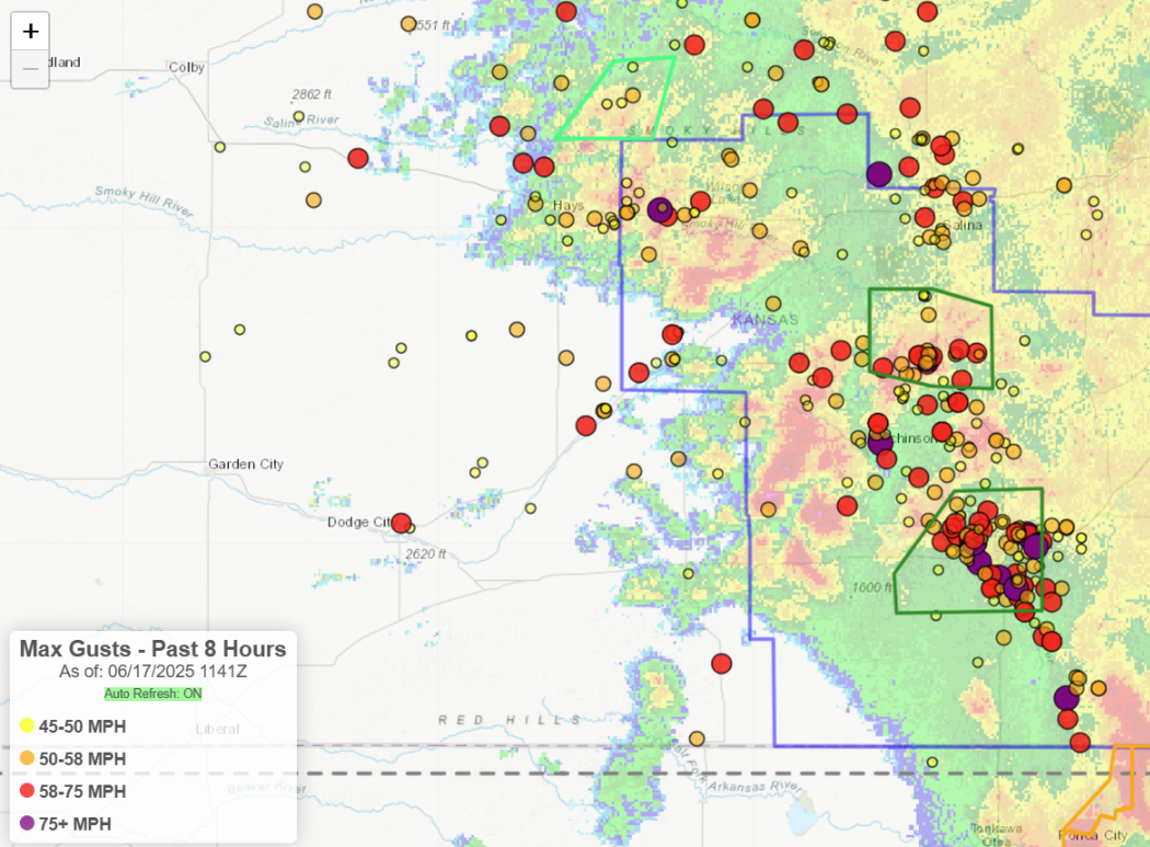
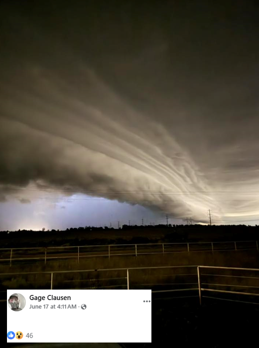
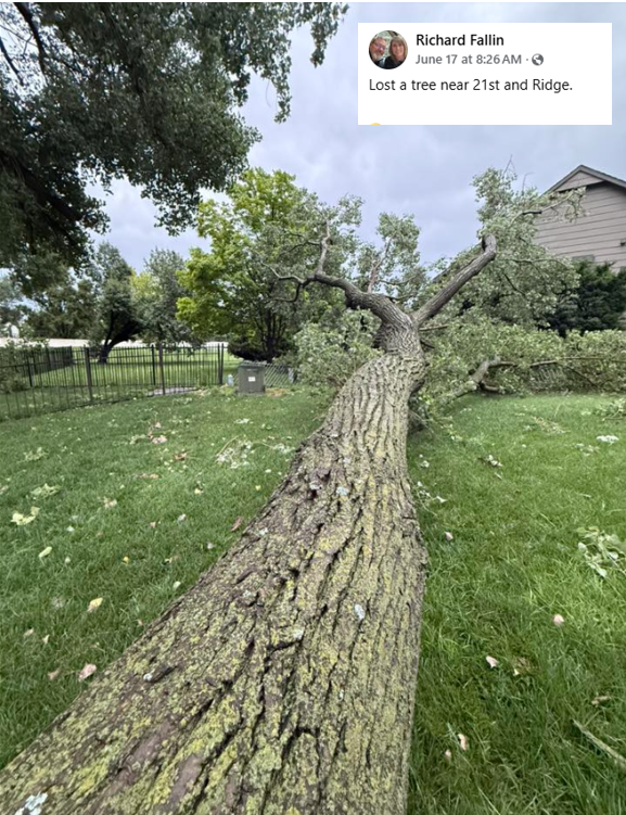
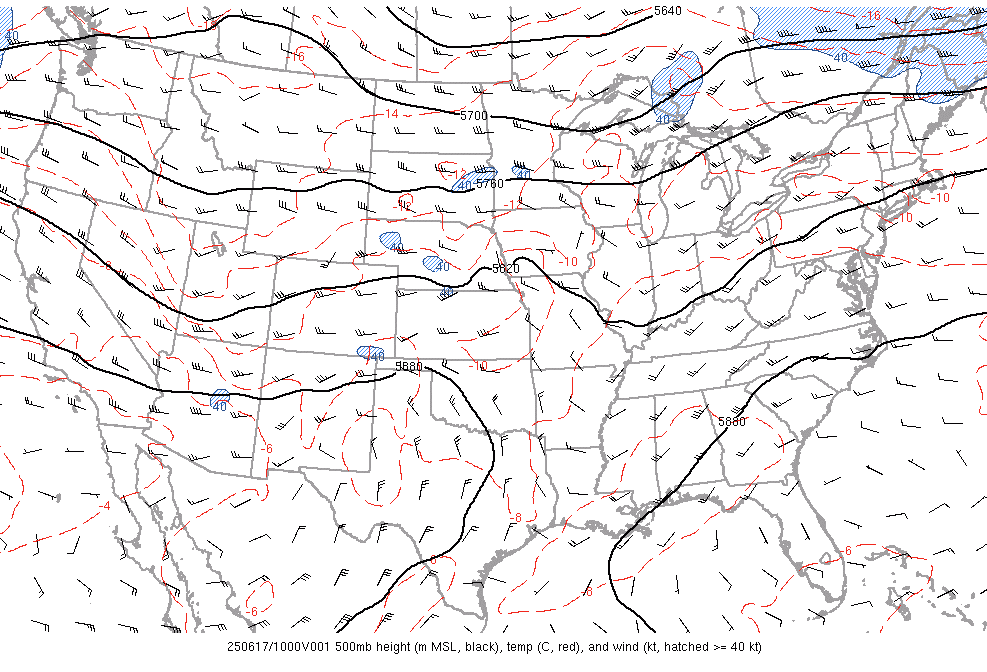
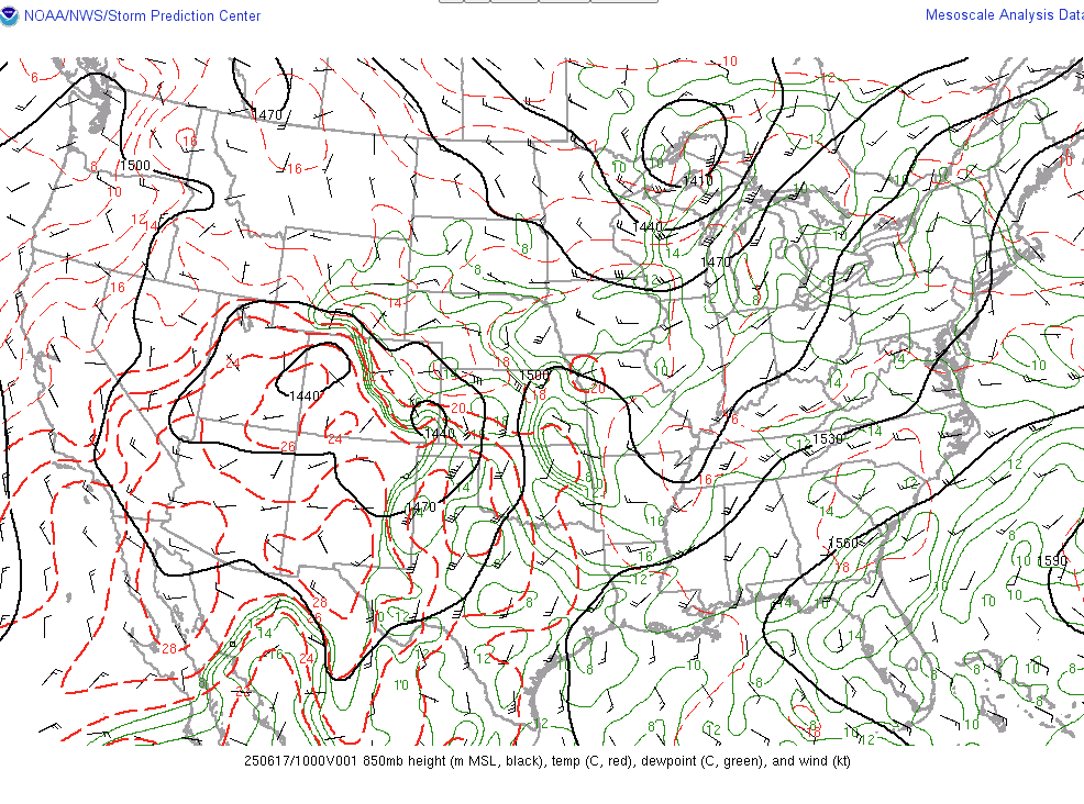
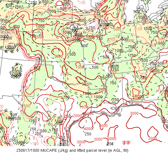
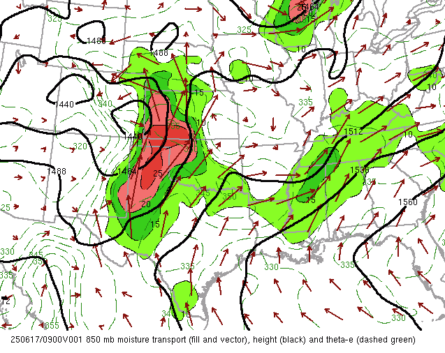
During the early morning hours of Tuesday June 17th, a line of storms developed into a bow echo as it progressed south. This line of storms produced extremely strong winds as it tracked south, with Hutchinson reporting an 89 mph gust and the Wichita Airport seeing a 102 mph gust! This was the strongest wind gust ever reported at the Wichita Airport! These extreme winds caused extensive damage with Sedgwick County receiving around 250 reports of power lines being down which resulted in around 85,000 residents with out power. Tree damage was very extensive throughout much of Wichita and surrounding areas. |
 Caption |
Photos & Video
 |
|
|
|
|
|
|
|
|
| Caption (source) |
Caption (source) |
Caption (source) |
| Caption (source) |
Caption (source) |
Caption (source) |
Radar
 |
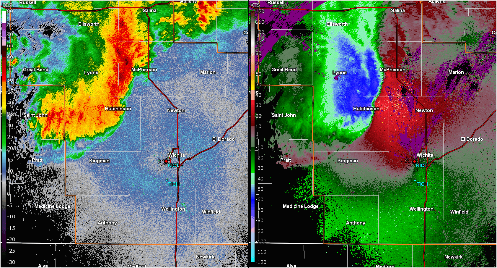 |
| Radar mosaic of the event | View of bow echo from Wichita's radar. This is the storm that produced the 102 mph gust |
Storm Reports
|
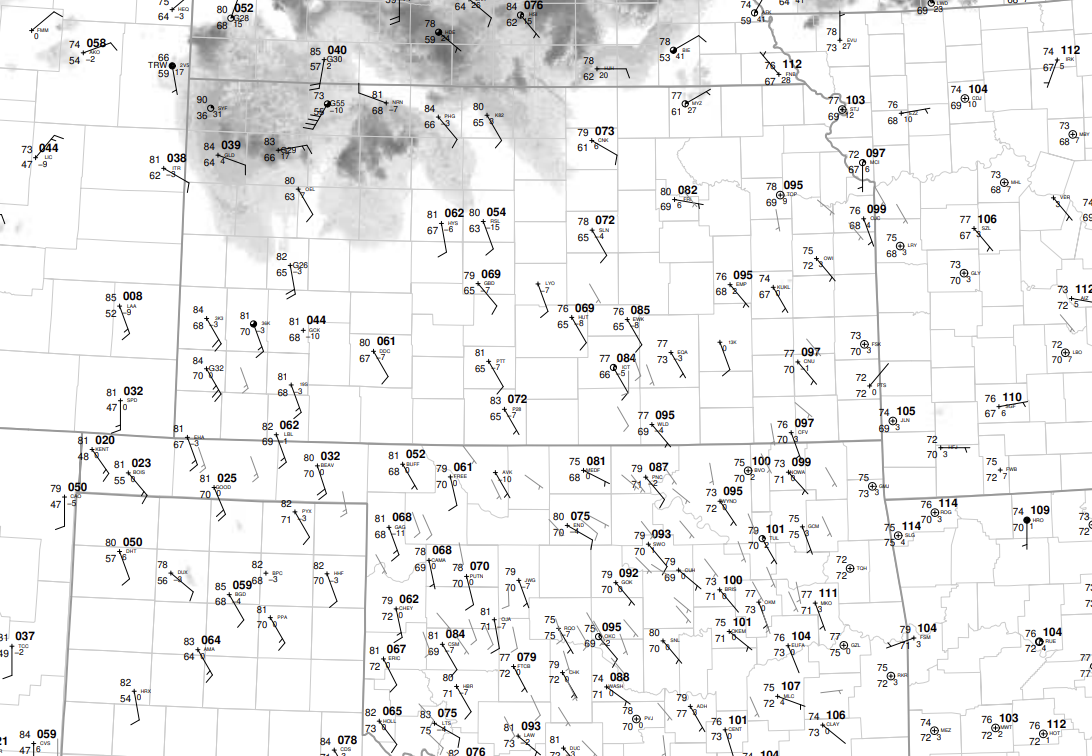
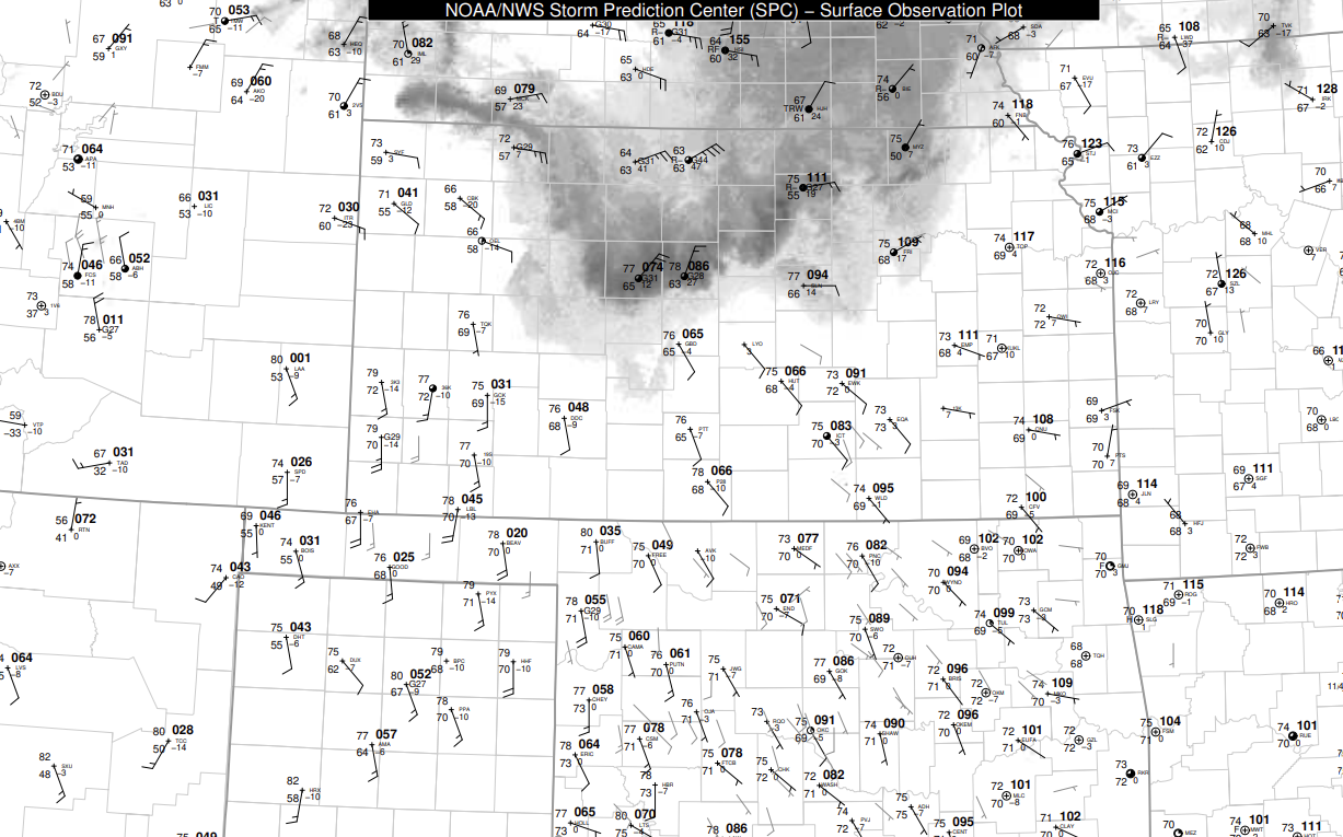
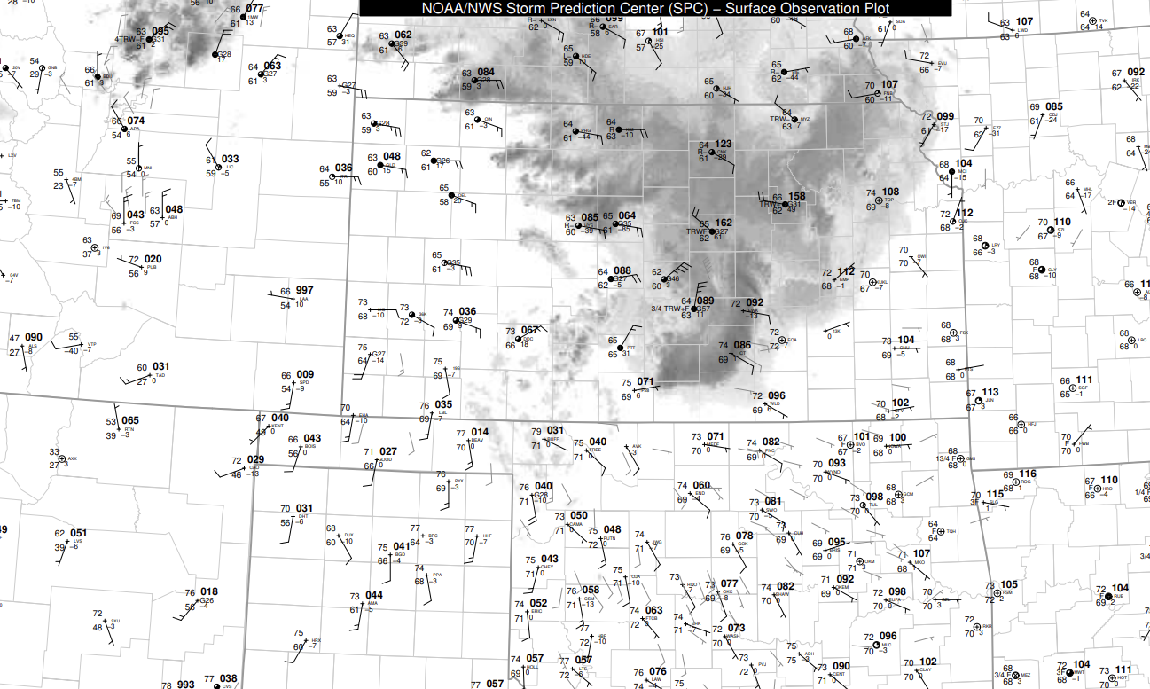
Severe wind reports from across the area |
0747 AM     Tstm Wnd Gst     4 N Clearwater          37.56N 97.51W
06/17/2025  M60 MPH          Sedgwick           KS   NWS Employee


0740 AM     Rain             1 NNE Mcpherson         38.39N 97.65W
06/17/2025  E4.00 Inch       McPherson          KS   Public

            KSKU Radio relayed report of 4 inches of
            rain.

0549 AM     Flash Flood      Mcpherson               38.37N 97.66W
06/17/2025                   McPherson          KS   911 Call Center

            Numerous roads are impassable within
            McPherson and in the county.

0548 AM     Tstm Wnd Gst     Arkansas City           37.06N 97.04W
06/17/2025  E60 MPH          Cowley             KS   Emergency Mngr


0544 AM     Tstm Wnd Dmg     2 SSW Winfield          37.24N 96.99W
06/17/2025                   Cowley             KS   Emergency Mngr

            Power outages reported in Winfield.

0540 AM     Tstm Wnd Dmg     4 NNE Arkansas City     37.12N 97.02W
06/17/2025                   Cowley             KS   Public

            Estimated 4 foot diameter cottonwood tree
            fell onto powerline which has since snapped
            that pole.

0539 AM     Tstm Wnd Gst     1 NNW Arkansas City     37.08N 97.05W
06/17/2025  M57 MPH          Cowley             KS   Trained Spotter


0535 AM     Tstm Wnd Gst     7 N Arkansas City       37.17N 97.03W
06/17/2025  M86 MPH          Cowley             KS   ASOS

            REPORTED AT KWLD.

0531 AM     Tstm Wnd Gst     7 N Arkansas City       37.17N 97.03W
06/17/2025  M81 MPH          Cowley             KS   ASOS

            ASOS station KWLD Strother Field Airport.

0508 AM     Flash Flood      3 W Downtown Wichita    37.68N 97.39W
06/17/2025                   Sedgwick           KS   Emergency Mngr

            Vehicle stuck in water up to door at Maple &
            S Tracy.

0507 AM     Tstm Wnd Gst     1 NW Udall              37.40N 97.13W
06/17/2025  M60 MPH          Cowley             KS   Fire Dept/Rescue


0501 AM     Flash Flood      4 NNW Wichita Eisenhowe 37.71N 97.47W
06/17/2025                   Sedgwick           KS   Emergency Mngr

            Several vehicles stalled in streets across
            Wichita. Maize &16th, s hydraulic &Walsall,
            central & Maize.

0456 AM     Tstm Wnd Gst     Benton                  37.79N 97.11W
06/17/2025  M62 MPH          Butler             KS   Trained Spotter


0455 AM     Tstm Wnd Gst     3 E East Wichita        37.69N 97.21W
06/17/2025  M63 MPH          Sedgwick           KS   AWOS

            AWOS station KBEC Beech Factory Airport.

0455 AM     Tstm Wnd Gst     Mcconnell Air Force Bas 37.62N 97.27W
06/17/2025  M61 MPH          Sedgwick           KS   AWOS

            AWOS station KIAB Mcconnell AFB.

0455 AM     Tstm Wnd Dmg     1 E Rose Hill           37.56N 97.11W
06/17/2025                   Butler             KS   Fire Dept/Rescue

            Two power poles snapped off. Time estimated
            from radar.

0454 AM     Tstm Wnd Dmg     Newton                  38.05N 97.34W
06/17/2025                   Harvey             KS   Emergency Mngr

            Street light blocking road in the 600 block
            of E. 36th in Newton.

0453 AM     Tstm Wnd Dmg     1 ESE Downtown Wichita  37.68N 97.32W
06/17/2025                   Sedgwick           KS   Emergency Mngr

            Several power lines down across Wichita
            metro.

0446 AM     Tstm Wnd Dmg     6 NNE Mount Hope        37.94N 97.61W
06/17/2025                   Harvey             KS   Emergency Mngr

            Large tree down across Burmac and 84th Road.

0442 AM     Tstm Wnd Dmg     2 SW East Wichita       37.67N 97.28W
06/17/2025                   Sedgwick           KS   Emergency Mngr

            Reported large tree fell on homes and a
            person was stuck inside home at 1200 block S
            Pershing. No injuries.

0441 AM     Tstm Wnd Dmg     1 WNW Derby             37.56N 97.27W
06/17/2025                   Sedgwick           KS   Public

            Several large 3 inch diameter tree branches
            down. Power pole leaning over roadway. Time
            estimated from radar.

0437 AM     Tstm Wnd Gst     1 WNW East Wichita      37.69N 97.28W
06/17/2025  E80 MPH          Sedgwick           KS   Public


0436 AM     Tstm Wnd Dmg     Newton                  38.05N 97.34W
06/17/2025                   Harvey             KS   Emergency Mngr

            Power line down at East 4th street.

0435 AM     Tstm Wnd Gst     Conway Springs          37.39N 97.64W
06/17/2025  E80 MPH          Sumner             KS   Trained Spotter


0435 AM     Tstm Wnd Gst     3 ESE Bel Aire          37.75N 97.22W
06/17/2025  M85 MPH          Sedgwick           KS   AWOS

            AWOS station KAAO 2 ESE Bel Aire.

0435 AM     Tstm Wnd Gst     3 ESE Bel Aire          37.75N 97.22W
06/17/2025  M85 MPH          Sedgwick           KS   AWOS

            REPORTED AT KAAO.

0434 AM     Tstm Wnd Gst     Jabara Airport          37.75N 97.22W
06/17/2025  M85 MPH          Sedgwick           KS   ASOS


0424 AM     Tstm Wnd Gst     1 W Canton              38.38N 97.44W
06/17/2025  M70 MPH          McPherson          KS   Mesonet

            Mesonet station UP317 0.8 W Canton (UPR).

0422 AM     Tstm Wnd Gst     1 SSE Wichita Eisenhowe 37.65N 97.43W
06/17/2025  M101 MPH         Sedgwick           KS   ASOS

            REPORTED AT KICT.

0408 AM     Tstm Wnd Dmg     4 N Mount Hope          37.93N 97.67W
06/17/2025                   Harvey             KS   Emergency Mngr

            Large tree down at SW 96th and Burmac Road.

0400 AM     Tstm Wnd Dmg     Halstead                38.00N 97.51W
06/17/2025                   Harvey             KS   Emergency Mngr

            Large tree down.

0357 AM     Tstm Wnd Gst     1 N Moundridge          38.22N 97.52W
06/17/2025  E70 MPH          McPherson          KS   Public

            At least 70 mph estimated.

0355 AM     Tstm Wnd Gst     2 SW Mcpherson          38.35N 97.69W
06/17/2025  M69 MPH          McPherson          KS   AWOS

            Measured at the McPherson Airport.

0354 AM     Tstm Wnd Gst     Mount Hope              37.87N 97.66W
06/17/2025  M80 MPH          Sedgwick           KS   Trained Spotter

            At least 80 mph in the city of Mount Hope.

0353 AM     Tstm Wnd Gst     Mount Hope              37.87N 97.66W
06/17/2025  M70 MPH          Sedgwick           KS   Trained Spotter


0338 AM     Tstm Wnd Gst     1 NNW Mcpherson         38.39N 97.67W
06/17/2025  E80 MPH          McPherson          KS   Trained Spotter

            Wind gusts between 70 to 80 mph estimated.

0331 AM     Tstm Wnd Gst     3 E Hutchinson          38.07N 97.87W
06/17/2025  M89 MPH          Reno               KS   ASOS

            ASOS station KHUT Hutchinson Municipal
            Airport.

0330 AM     Tstm Wnd Gst     2 W Inman               38.23N 97.82W
06/17/2025  M80 MPH          McPherson          KS   Trained Spotter

            Spotter estimated 70-80 mph wind gusts. Very
            heavy rainfall as well.

0302 AM     Tstm Wnd Gst     2 W Little River        38.40N 98.05W
06/17/2025  M65 MPH          Rice               KS   Mesonet

            Report from Kansas Mesonet.

0255 AM     Tstm Wnd Gst     2 W Lyons               38.35N 98.23W
06/17/2025  M60 MPH          Rice               KS   AWOS

            AWOS station KLYO Lyons Rice Co. Municipal
            Airpt.

0234 AM     Tstm Wnd Gst     3 N New Cambria         38.92N 97.51W
06/17/2025  M62 MPH          Saline             KS   Mesonet


0232 AM     Tstm Wnd Gst     3 ENE New Cambria       38.89N 97.45W
06/17/2025  M69 MPH          Saline             KS   Mesonet

            Mesonet station UR445 3.2 E New Cambria
            (UPR).

0212 AM     Tstm Wnd Gst     3 NE Pawnee Rock        38.30N 98.94W
06/17/2025  M58 MPH          Barton             KS   Mesonet


0134 AM     Tstm Wnd Gst     Russell Airport         38.87N 98.82W
06/17/2025  M67 MPH          Russell            KS   ASOS

            ASOS station KRSL Russell Municipal Airport.

0125 AM     Tstm Wnd Gst     Russell Airport         38.87N 98.82W
06/17/2025  M58 MPH          Russell            KS   ASOS

            ASOS station KRSL Russell Municipal Airport.

0125 AM     Tstm Wnd Gst     Lincoln                 39.04N 98.15W
06/17/2025  E70 MPH          Lincoln            KS   Trained Spotter

            Spotter also lost power with the strong
            winds.
Environment
 |
 |
 |
|
June 17th 03z Surface Map |
June 17th 06z Surface Map |
June 17th 09z Surface Map |
 |
 |
Additional Information
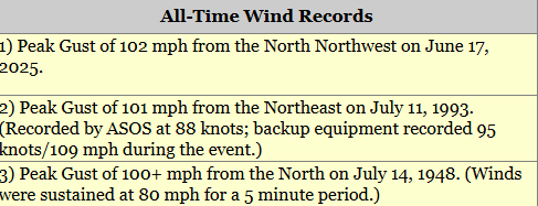 |
| This event set the highest wind gust record for Wichita at 102 mph. |
 |
Media use of NWS Web News Stories is encouraged! Please acknowledge the NWS as the source of any news information accessed from this site. |
|