Overview
|
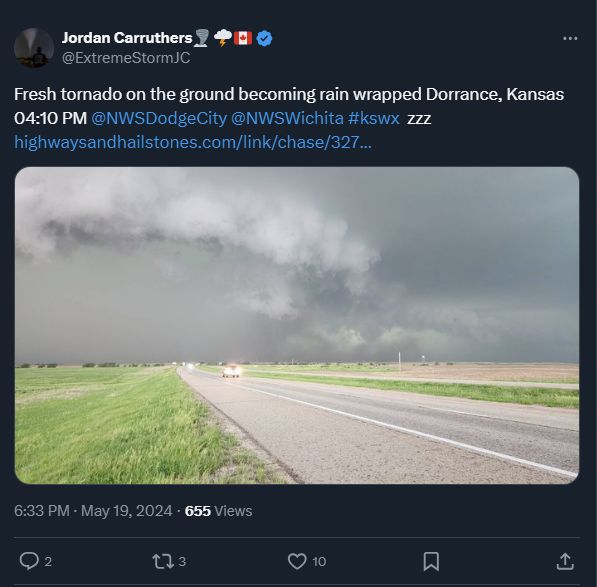
Around 2:30pm on Sunday May 19th, a high precipitation supercell developed near Hays along a warm front. This storm tracked east along I-70, producing a few brief tornadoes across Russell and northern Ellsworth County. As it progressed east, the wind and hail threat ramp-up as it moved into Saline County. The Salina Airport measured a 100 mph wind gust! There was also numerous reports of golf ball size hail across Salina. A rapidly moving line of storms called a derecho then moved out of western Kansas and into Reno and Kingman counties shortly after 7 pm. This intense line of storms produced widespread 70 to 90 mph winds as it raced off to the northeast at 70 to 80 mph. Hardest hit were the communities of Hutchinson Haven, Burrton, Halstead and Newton where widespread tree damage and power outages were reported. Damage was also reported across southern Marion and northern Butler counties with tornado damage was documented near Burns. The destructive line of storms continued to produce damaging winds as it tracked toward Kansas City late Sunday night. |
 |
Central Kansas Supercell with tornadoes
|
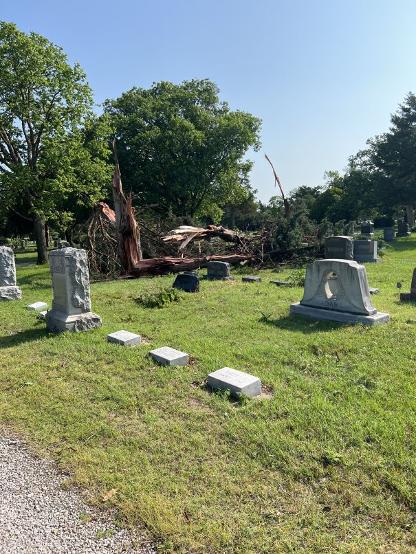
Northwest of Russell
Track Map 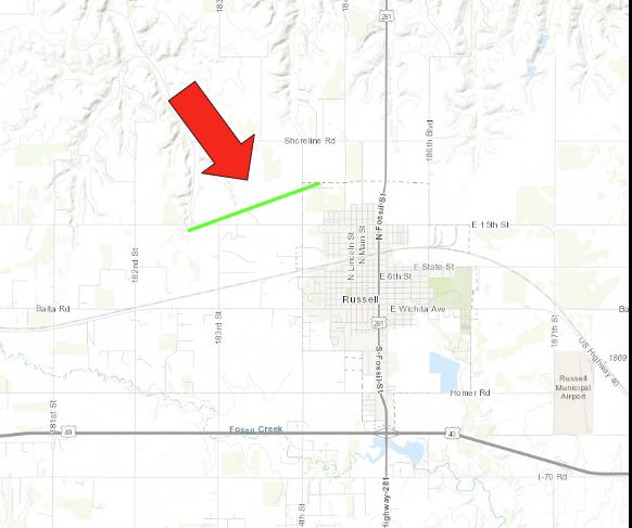 
|
||||||||||||||
|
Northeast of Wilson
Track Map 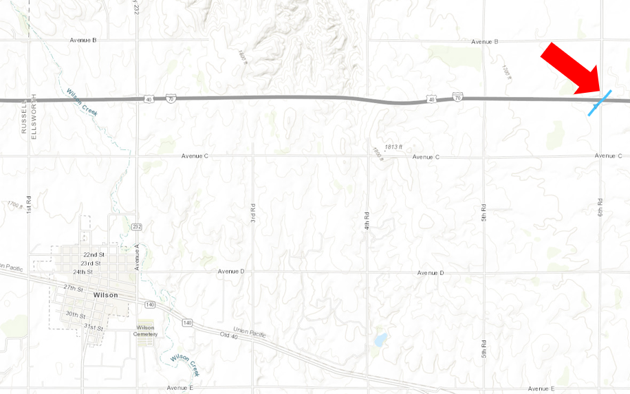
|
||||||||||||||
|
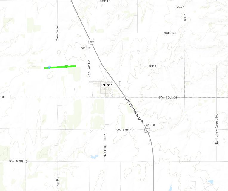
West of Burns
Track Map
|
||||||||||||||||||
|
Northwest of Ellinwood
Track Map .jpg)
|
||||||||||||||
The Enhanced Fujita (EF) Scale classifies tornadoes into the following categories:
| EF0 Weak 65-85 mph |
EF1 Moderate 86-110 mph |
EF2 Significant 111-135 mph |
EF3 Severe 136-165 mph |
EF4 Extreme 166-200 mph |
EF5 Catastrophic 200+ mph |
 |
|||||
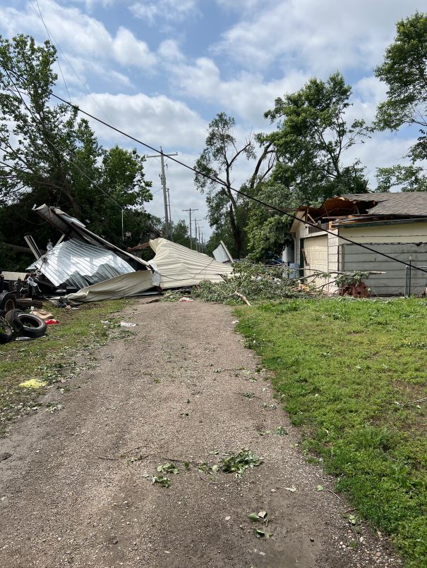
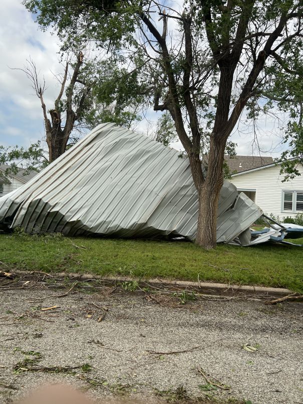
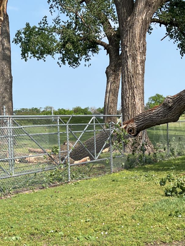
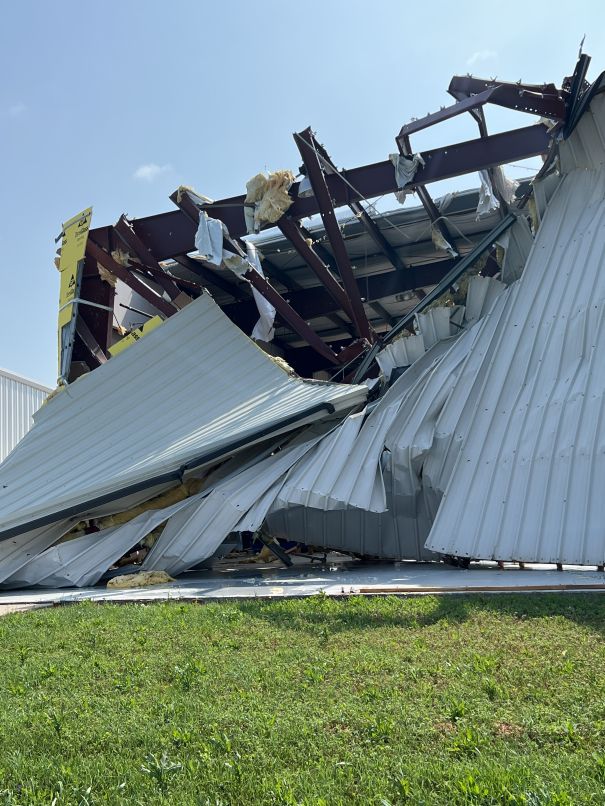
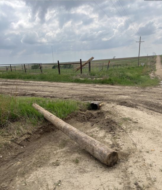
Additional pictures from the HP Supercell that affected Central Kansas
|
|
|
|
|
|
|
|
|
|
|
|
|
here | here |
Derecho
| By definition it is considered a derecho if the swath of wind damage extends at least 400 miles (about 650 kilometers), is at least 60 miles (about 100 km) wide, includes wind gusts of at least 58 mph (93 km/h) along most of its length, and also includes several, well-separated 75 mph (121 km/h) or greater gusts, |
|
|
Straight-line wind damage in Burrton |
Straight-line wind damage in Burrton |
Straight-line wind damage near Halstead |
|
Straight-line wind damage east of Newton |
Straight-line wind damage near Newton |
Straight-line wind damage east of Newton |
|
|
|
|
|
|
|
|
here |
Radar
 |
 |
| Radar animation from the HP Supercell that tracked along I-70 | Radar animation of the derecho as it tracked across south central KS |
Storm Reports
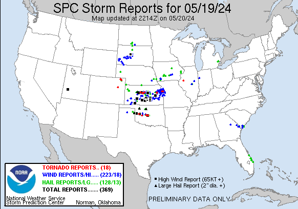 |
Preliminary Local Storm Report...Summary
National Weather Service Wichita KS
1255 AM CDT Mon May 20 2024
..TIME... ...EVENT... ...CITY LOCATION... ...LAT.LON...
..DATE... ....MAG.... ..COUNTY LOCATION..ST.. ...SOURCE....
..REMARKS..
0327 PM Tornado 4 ESE Gorham 38.87N 98.96W
05/19/2024 Russell KS Broadcast Media
Broadcast media reports tornado west of
Russell.
0342 PM Hail Russell 38.89N 98.86W
05/19/2024 E2.50 Inch Russell KS Public
0342 PM Hail Russell 38.89N 98.85W
05/19/2024 E1.25 Inch Russell KS Public
0343 PM Tstm Wnd Gst Russell 38.89N 98.86W
05/19/2024 E70 MPH Russell KS Public
0345 PM Hail 1 SSE Russell 38.87N 98.85W
05/19/2024 M1.75 Inch Russell KS Public
Picture and video sent via X.
0347 PM Tstm Wnd Gst Russell Airport 38.87N 98.81W
05/19/2024 M82 MPH Russell KS ASOS
0348 PM Hail Russell 38.89N 98.85W
05/19/2024 M1.75 Inch Russell KS Public
Spotter reported large trees being blown
down.
0352 PM Tstm Wnd Gst Sylvan Grove 39.02N 98.39W
05/19/2024 E70 MPH Lincoln KS Public
0412 PM Tornado 1 NNE Dorrance 38.86N 98.58W
05/19/2024 Russell KS Public
Picture sent via X.
0419 PM Hail Wilson 38.82N 98.47W
05/19/2024 M1.75 Inch Ellsworth KS Law Enforcement
0423 PM Tornado 4 SSE Wilson 38.78N 98.45W
05/19/2024 Ellsworth KS Law Enforcement
0446 PM Tornado 7 S Lincoln 38.93N 98.15W
05/19/2024 Lincoln KS Trained Spotter
Dust being kicked up but believe it is rain
wrapped.
0449 PM Tstm Wnd Gst 10 WSW Westfall 38.88N 98.17W
05/19/2024 E60 MPH Lincoln KS Public
0449 PM Hail 10 WSW Westfall 38.88N 98.17W
05/19/2024 E1.00 Inch Lincoln KS Public
0453 PM Tstm Wnd Gst 5 N Ellsworth 38.81N 98.23W
05/19/2024 E60 MPH Ellsworth KS Trained Spotter
Spotter reported torrential rainfall.
0455 PM Hail 6 S Dorrance 38.76N 98.58W
05/19/2024 E1.50 Inch Russell KS Trained Spotter
0507 PM Hail 1 S Russell Airport 38.86N 98.82W
05/19/2024 E2.00 Inch Russell KS Public
0514 PM Hail Wilson 38.83N 98.47W
05/19/2024 E1.00 Inch Ellsworth KS Law Enforcement
0525 PM Hail Ellsworth 38.73N 98.23W
05/19/2024 M1.00 Inch Ellsworth KS Trained Spotter
Nickel to quarter sized hail in town. No
wind damage found.
0540 PM Tstm Wnd Dmg Brookville 38.77N 97.87W
05/19/2024 Saline KS Emergency Mngr
Powerlines and tree lines are down. Time is
estimated from radar.
0540 PM Hail 3 ENE Glendale 38.91N 97.81W
05/19/2024 M1.75 Inch Saline KS Public
Picture of what appears to be golf ball
sized hail on X.
0540 PM Flood 6 N Ellsworth 38.83N 98.22W
05/19/2024 Ellsworth KS Law Enforcement
Water reported over the roadway at Kansas
Highway 14 and Avenue D.
0540 PM Flood 5 ENE Wilson 38.85N 98.39W
05/19/2024 Ellsworth KS Law Enforcement
Water over the roadway at Interstate 70 and
6th Road.
0546 PM Hail 2 NNW Salina 38.84N 97.64W
05/19/2024 E1.50 Inch Saline KS Emergency Mngr
Ping Pong size hail on State Street just
west of Salina.
0554 PM Hail 2 N Salina 38.84N 97.62W
05/19/2024 E1.75 Inch Saline KS Public
0559 PM Tstm Wnd Gst Salina Airport 38.79N 97.65W
05/19/2024 M100 MPH Saline KS ASOS
0605 PM Tstm Wnd Dmg Salina 38.83N 97.62W
05/19/2024 Saline KS Emergency Mngr
Powerlines and trees are down in Salina.
0615 PM Hail 6 E Geneseo 38.52N 98.04W
05/19/2024 M1.50 Inch Rice KS Public
KWCH shared picture of hail larger than
quarters.
0618 PM Hail 5 ESE New Cambria 38.84N 97.43W
05/19/2024 M1.00 Inch Saline KS Emergency Mngr
0639 PM Flood Salina 38.83N 97.61W
05/19/2024 Saline KS Emergency Mngr
Flooding is occurring on Crawford Street
from Front to 3rd.
0645 PM Tstm Wnd Gst 2 ENE Great Bend 38.37N 98.78W
05/19/2024 E60 MPH Barton KS Trained Spotter
0649 PM Tstm Wnd Gst Great Bend Airport 38.35N 98.87W
05/19/2024 M58 MPH Barton KS ASOS
0652 PM Tstm Wnd Gst Ellinwood 38.36N 98.58W
05/19/2024 E60 MPH Barton KS CO-OP Observer
0702 PM Tstm Wnd Dmg 3 SE Lindsborg 38.55N 97.63W
05/19/2024 McPherson KS Emergency Mngr
power lines down.
0702 PM Tstm Wnd Gst Mcpherson 38.37N 97.67W
05/19/2024 E60 MPH McPherson KS NWS Employee
0706 PM Tstm Wnd Gst 1 N Langdon 37.87N 98.33W
05/19/2024 E70 MPH Reno KS Emergency Mngr
0711 PM Hail 3 W Durham 38.49N 97.28W
05/19/2024 M0.88 Inch Marion KS Trained Spotter
0712 PM Tstm Wnd Gst Penalosa 37.72N 98.32W
05/19/2024 M70 MPH Kingman KS Trained Spotter
At least 70 mph winds, could have been
higher. Four inch diameter tree limbs down.
0715 PM Tstm Wnd Gst 1 W Lyons 38.34N 98.23W
05/19/2024 M56 MPH Rice KS AWOS
Measured at Lyons Airport.
0716 PM Tstm Wnd Gst 3 E Partridge 37.96N 98.04W
05/19/2024 M67 MPH Reno KS Mesonet
Delayed report. Measured by Kansas State
mesonet site.
0720 PM Hail 7 WSW Mcpherson 38.33N 97.78W
05/19/2024 M1.25 Inch McPherson KS Trained Spotter
0725 PM Tstm Wnd Dmg Mcpherson 38.37N 97.66W
05/19/2024 McPherson KS Emergency Mngr
Powerlines down in the 660 block of West
Hayes.
0725 PM Tstm Wnd Gst Mcpherson 38.37N 97.67W
05/19/2024 M60 MPH McPherson KS NWS Employee
Off duty NWS employee reporting 60 mph
winds.
0725 PM Tstm Wnd Gst Kingman 37.65N 98.11W
05/19/2024 E80 MPH Kingman KS Public
Lots of tree limbs in the roads and power is
out to some of the town.
0729 PM Tstm Wnd Gst 1 NNW Kingman 37.67N 98.13W
05/19/2024 M56 MPH Kingman KS AWOS
Measured at Kingman airport.
0735 PM Tstm Wnd Dmg Haven 37.90N 97.78W
05/19/2024 Reno KS Emergency Mngr
Roofs blown off of homes.
0736 PM Tstm Wnd Dmg 1 WSW Hutchinson 38.06N 97.93W
05/19/2024 Reno KS Broadcast Media
KAKE reporting roof blown off of a building
on south Main Street.
0736 PM Tstm Wnd Gst Hutchinson 38.07N 97.93W
05/19/2024 M70 MPH Reno KS Mesonet
KAKE Weathernow Network measures 70 mph
winds.
0737 PM Tstm Wnd Dmg South Hutchinson 38.04N 97.93W
05/19/2024 Reno KS Emergency Mngr
Multiple power lines down as well as
structural damage reported. Time based on
other reports.
0740 PM Tstm Wnd Gst 1 S Mount Hope 37.85N 97.66W
05/19/2024 E80 MPH Sedgwick KS Trained Spotter
0740 PM Tstm Wnd Gst Hutchinson Airport 38.07N 97.86W
05/19/2024 M86 MPH Reno KS ASOS
0746 PM Hail Hillsboro 38.35N 97.21W
05/19/2024 E0.88 Inch Marion KS Trained Spotter
Pea to nickel sized hail.
0747 PM Tstm Wnd Gst 5 NW Halstead 38.05N 97.56W
05/19/2024 E60 MPH Harvey KS Trained Spotter
0753 PM Tstm Wnd Gst 3 SE Maize 37.75N 97.42W
05/19/2024 M59 MPH Sedgwick KS NWS Employee
Davis Weather Station near 34th St. N and
Ridge Rd.
0755 PM Tstm Wnd Dmg NW Wichita 37.74N 97.37W
05/19/2024 Sedgwick KS Emergency Mngr
Several power lines reported down in
northwest Wichita.
0755 PM Tstm Wnd Gst 4 N Hesston 38.20N 97.43W
05/19/2024 E65 MPH McPherson KS Trained Spotter
0755 PM Hail 4 N Hesston 38.20N 97.43W
05/19/2024 E1.00 Inch McPherson KS Trained Spotter
Quarter sized hail and 65 mph winds
reported.
0756 PM Flood Mcpherson 38.37N 97.66W
05/19/2024 McPherson KS Emergency Mngr
Lots of street flooding reported in town.
0800 PM Tstm Wnd Dmg 6 NE Valley Center 37.90N 97.30W
05/19/2024 Sedgwick KS NWS Employee
Delayed report. Roof blown off a metal
outbuilding.
0802 PM Tstm Wnd Gst 4 ENE Newton 38.06N 97.28W
05/19/2024 M64 MPH Harvey KS AWOS
Newton Airport.
0803 PM Tstm Wnd Gst 1 WSW Whitewater 37.96N 97.17W
05/19/2024 M72 MPH Harvey KS NWS Employee
Off duty NWS employee had measurement of 72
mph.
0804 PM Tstm Wnd Gst Whitewater 37.97N 97.15W
05/19/2024 E80 MPH Butler KS Fire Dept/Rescue
Whitewater Fire Department estimates 70 to
80 mph winds.
0805 PM Tstm Wnd Dmg Bentley 37.89N 97.52W
05/19/2024 Sedgwick KS Emergency Mngr
Power lines down.
0806 PM Tstm Wnd Gst 3 ESE Bel Aire 37.75N 97.22W
05/19/2024 M64 MPH Sedgwick KS ASOS
Measured at Jabara Airport.
0808 PM Tstm Wnd Dmg Newton 38.04N 97.34W
05/19/2024 Harvey KS Broadcast Media
Extensive tree damage in and around Newton,
many roads blocked. Courtesy of AccuWeather.
0811 PM Tstm Wnd Gst 2 NE East Wichita 37.71N 97.23W
05/19/2024 M75 MPH Sedgwick KS Broadcast Media
Measured near 13th and Webb. Courtesy of
KAKE TV.
0811 PM Hail 3 W Peabody 38.17N 97.15W
05/19/2024 E1.75 Inch Marion KS Trained Spotter
0813 PM Tstm Wnd Dmg Potwin 37.94N 97.02W
05/19/2024 Butler KS Fire Dept/Rescue
6 to 12 inch diameter tree limbs are
reported down.
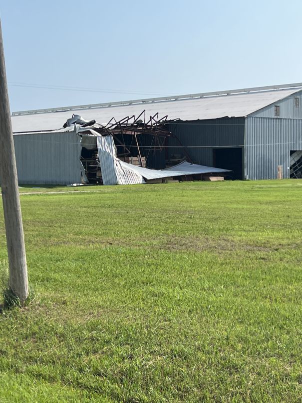
0818 PM Tstm Wnd Dmg Burns 38.09N 96.89W
05/19/2024 Marion KS Emergency Mngr
Delayed report. On 20th street in Burns, a
40 by 60 foot polebarn was taken down, and a
chicken coop was blown into a hedge row.
Time estimated from radar.
0818 PM Tstm Wnd Dmg Towanda 37.80N 97.00W
05/19/2024 Butler KS Emergency Mngr
Delayed report. Sporadic tree limbs down
across the city. All limbs appear to be less
than 5 inches in diameter.
0818 PM Tstm Wnd Gst Andover 37.68N 97.14W
05/19/2024 E60 MPH Butler KS Fire Dept/Rescue
0820 PM Tstm Wnd Gst 3 SW Burns 38.06N 96.91W
05/19/2024 M68 MPH Butler KS Fire Dept/Rescue
0821 PM Tstm Wnd Gst Burns 38.09N 96.89W
05/19/2024 E70 MPH Marion KS Fire Dept/Rescue
60 to 70 mph winds.
0825 PM Tstm Wnd Gst 3 W Augusta 37.68N 97.03W
05/19/2024 E60 MPH Butler KS Trained Spotter
0825 PM Tstm Wnd Gst El Dorado 37.83N 96.86W
05/19/2024 E60 MPH Butler KS Trained Spotter
0833 PM Tstm Wnd Gst Cassoday 38.04N 96.64W
05/19/2024 E60 MPH Butler KS Trained Spotter
one to two inch diameter tree limbs downed.
0834 PM Tstm Wnd Dmg 4 ESE Augusta 37.68N 96.90W
05/19/2024 Butler KS Emergency Mngr
6 inch diameter tree damage.
0835 PM Tstm Wnd Gst 4 SE El Dorado 37.78N 96.82W
05/19/2024 M58 MPH Butler KS AWOS
Measured at the airport.
0836 PM Tstm Wnd Dmg Matfield Green 38.16N 96.56W
05/19/2024 Chase KS Law Enforcement
Cedar tree blown over. Time is estimated
from radar.
0853 PM Tstm Wnd Gst 8 SW Thrall 37.92N 96.42W
05/19/2024 E55 MPH Greenwood KS Trained Spotter
Pea size hail accompanied the wind.
0855 PM Tstm Wnd Gst Eureka Airport 37.85N 96.29W
05/19/2024 M60 MPH Greenwood KS AWOS
0857 PM Flood 2 W East Wichita 37.68N 97.30W
05/19/2024 Sedgwick KS Public
Street flooding noted via social media video
at intersection of Hillside and Waterman.
0910 PM Tstm Wnd Gst 4 N Virgil 38.04N 96.01W
05/19/2024 E60 MPH Greenwood KS Trained Spotter
0912 PM Rain 3 W Augusta 37.68N 97.03W
05/19/2024 M1.70 Inch Butler KS Trained Spotter
Rainfall total for this evening.
0927 PM Tstm Wnd Gst 7 WSW Neosho Falls 37.98N 95.69W
05/19/2024 E60 MPH Woodson KS Trained Spotter
0930 PM Tstm Wnd Gst 3 WSW Yates Center 37.86N 95.79W
05/19/2024 M55 MPH Woodson KS Mesonet
Kansas State Mesonet site.
0945 PM Tstm Wnd Gst 1 W Chanute 37.67N 95.48W
05/19/2024 M54 MPH Neosho KS ASOS
0955 PM Tstm Wnd Dmg Humboldt 37.81N 95.43W
05/19/2024 Allen KS Emergency Mngr
Trees and 4 inch diameter limbs down in
Humboldt.
1018 PM Hail 1 NE North Newton 38.08N 97.34W
05/19/2024 E1.00 Inch Harvey KS Trained Spotter
Time estimated by radar.
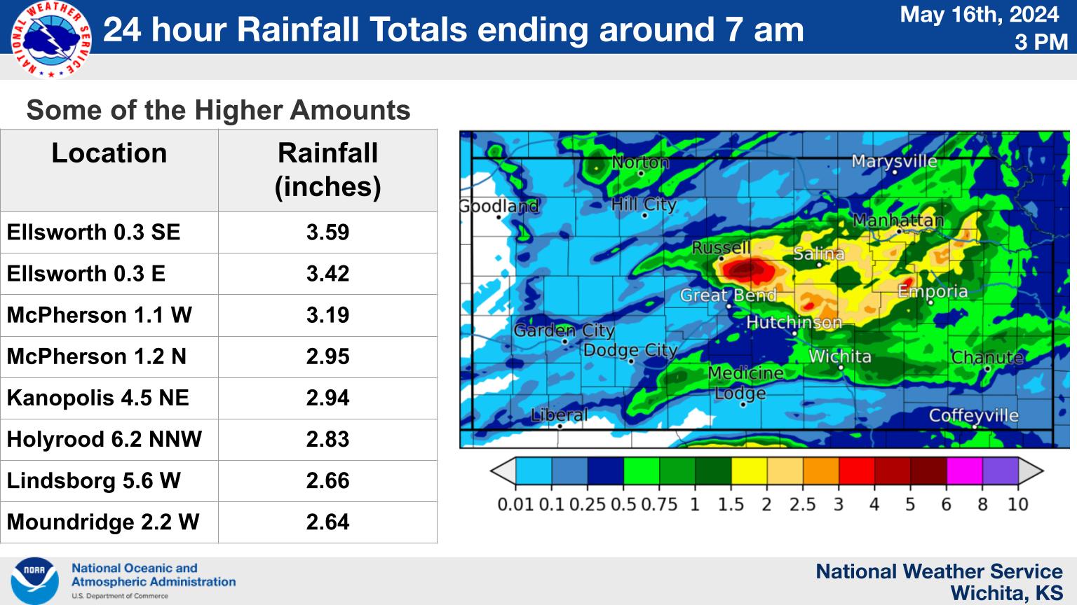
Rain Reports
Environment
Insert synoptic summary.
| Figure 1: Caption | Figure 2: Caption | Figure 3: Caption |
Near-storm environment summary.
| Figure 4: Caption | Figure 5: Caption | Figure 6: Caption |
Additional environmental data.
| Figure 7: Caption | Figure 8: Caption | Figure 9: Caption |
 |
Media use of NWS Web News Stories is encouraged! Please acknowledge the NWS as the source of any news information accessed from this site. |
|


.jpg)
.jpg)