
Isolated severe thunderstorms with locally damaging wind gusts and hail are possible Monday across parts of the Southeast U.S. Elevated to critical fire weather including gusty winds and low relative humidity is forecast Monday over much of the northern Great Plains. Above normal temperatures in the Southeast and Southwest U.S. will bring moderate to isolated major HeatRisk Monday. Read More >
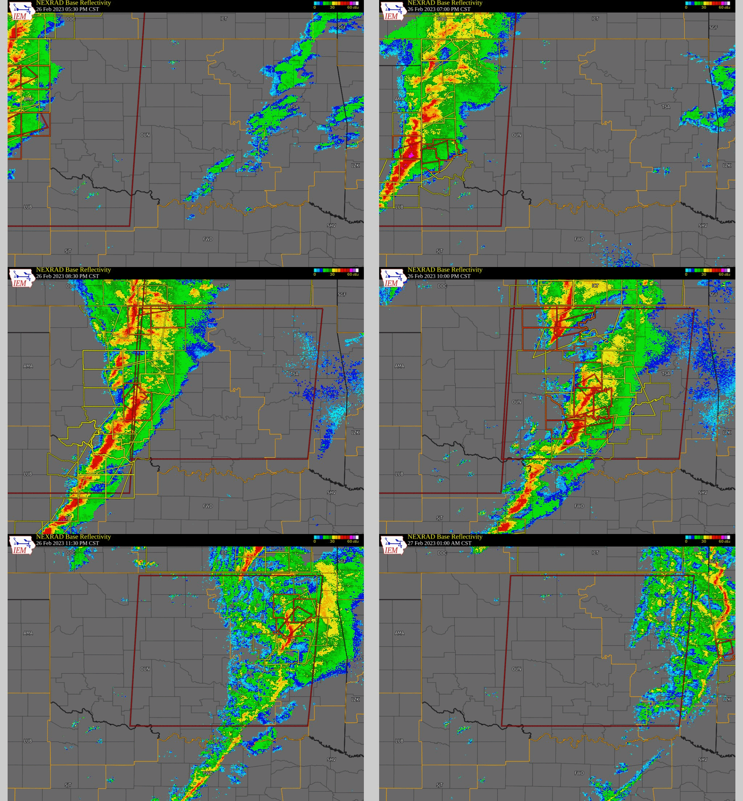
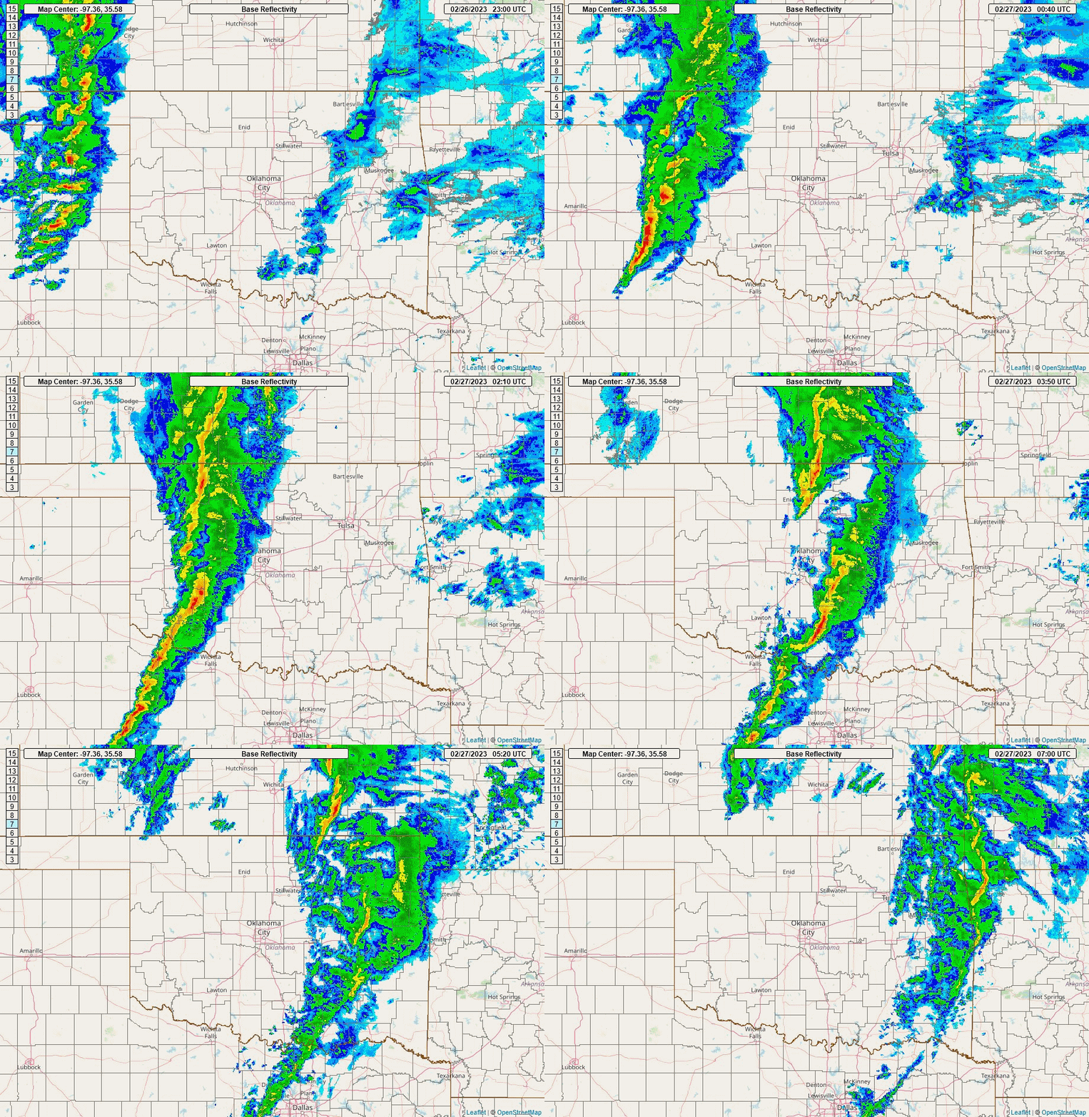
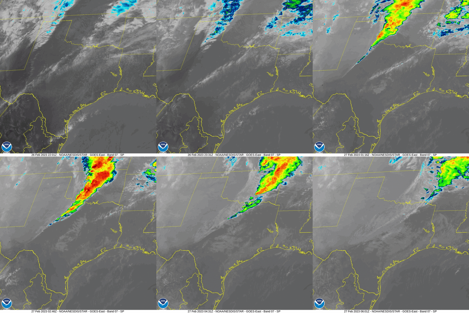
A potent, late February storm system produced an outbreak of tornadoes and other severe weather across Oklahoma and western north Texas during the late afternoon and evening hours of February 26, 2023. Hail up to the size of golf balls and severe wind gusts of 58-85 mph were observed during this event. Teams from NWS Norman conducted damage path surveys in central Oklahoma on February 27, 2023 and confirmed 5 tornadoes (3 EF-1 & 2 EF-2 tornadoes) in the area. More surveys had been conducted in western Oklahoma on February 28-March 1, 2023. A total of 13 tornadoes in western, southwestern, north central and central Oklahoma have been documented in the NWS Norman forecast area.
The 13 tornadoes documented for this event is the greatest total of tornadoes to occur in Oklahoma during the month of February since officials records began in 1950. The previous record total was 6 and occurred in February of 1975 and 2009.
More information regarding this severe weather outbreak will be added as it becomes available.
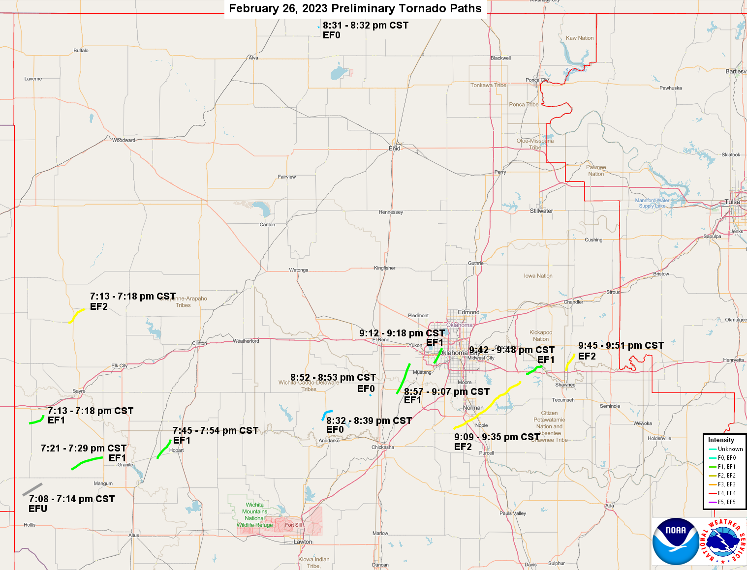
NOUS44 KOUN 031714 CCA
PNSOUN
OKZ004>048-050>052-TXZ083>090-040515-

Public Information Statement
National Weather Service Norman OK
1106 AM CST Fri Mar 3 2023

...NWS Damage Survey for 2/26/2023 Tornado Event - Update # 4...

.Update...Added tornado near Gracemont. Final update for the
tornadoes of February 26th. Correction to Hollis area tornado winds.

.Overview...A tornado outbreak occurred across Oklahoma on Sunday
February 26. A total of twelve tornadoes have been confirmed,
all listed below.

Additional damage was noted across Oklahoma,
including areas near Alabaster Caverns State Park, Enid, Prague,
and Fort Cobb lake. For these additional areas, the bulk of the
evidence suggests the damage was from straight line winds. NWS
Norman will continue to look at damage evidence and make a final
determination in time for finalization in Storm Data.

.Cheyenne Tornado...

Rating:                 EF2
Estimated Peak Wind:    125 to 130 mph
Path Length /statute/:  7 miles
Path Width /maximum/:   500 yards
Fatalities:             1
Injuries:               To be determined

Start Date:             02/26/2023
Start Time:             07:13 PM CST
Start Location:         2 W Cheyenne / Roger Mills County / OK
Start Lat/Lon:          35.61 / -99.70

End Date:               02/26/2023
End Time:               07:18 PM CST
End Location:           1 W Strong City / Roger Mills County / OK
End Lat/Lon:            35.67 / -99.61

.Tornado South of Erick...

Rating:                 EF1
Estimated Peak Wind:    95 to 100 mph
Path Length /statute/:  6 miles
Path Width /maximum/:   100 yards
Fatalities:             0
Injuries:               0

Start Date:             02/26/2023
Start Time:             07:13 PM CST
Start Location:         5 SW Erick / Beckham County / OK
Start Lat/Lon:          35.15 / -99.92

End Date:               02/26/2023
End Time:               07:18 PM CST
End Location:           2 SE Erick / Beckham County / OK
End Lat/Lon:            35.19 / -99.84

..Tornado Between Hollis and Willow...

Rating:                 EF0
Estimated Peak Wind:    80 mph
Path Length /statute/:  8.56 miles
Path Width /maximum/:   75 yards
Fatalities:             0
Injuries:               0

Start Date:             02/27/2023
Start Time:             07:21 PM CST
Start Location:         8 E Vinson / Greer County / OK
Start Lat/Lon:          34.8928 / -99.7186

End Date:               02/27/2023
End Time:               07:29 PM CST
End Location:           5 SW Brinkman / Greer County / OK
End Lat/Lon:            34.9545 / -99.5885

.Tornado between Lone Wolf and Hobart...

Rating:                 EF1
Estimated Peak Wind:    100 to 105 mph
Path Length /statute/:  8 miles
Path Width /maximum/:   600 yards
Fatalities:             0
Injuries:               0

Start Date:             02/26/2023
Start Time:             07:45 PM CST
Start Location:         2 E Lone Wolf / Kiowa County / OK
Start Lat/Lon:          34.99 / -99.20

End Date:               02/26/2023
End Time:               07:54 PM CST
End Location:           3 NNW Hobart / Kiowa County / OK
End Lat/Lon:            35.08 / -99.13

.Amorita...

Rating:                 EF0
Estimated Peak Wind:    80 mph
Path Length /statute/:  0.15 miles
Path Width /maximum/:   50 yards
Fatalities:             0
Injuries:               0

Start Date:             02/26/2023
Start Time:             08:31 PM CST
Start Location:         1 NNW Amorita / Alfalfa County / OK
Start Lat/Lon:          36.9398 / -98.3062

End Date:               02/26/2023
End Time:               08:32 PM CST
End Location:           1 NNW Amorita / Alfalfa County / OK
End Lat/Lon:            36.9414 / -98.3044

.Tornado near Gracemont...

Rating:                 EF0
Estimated Peak Wind:    80 mph
Path Length /statute/:  5.10 miles
Path Width /maximum/:   75 yards
Fatalities:             0
Injuries:               0

Start Date:             02/26/2023
Start Time:             08:32 PM CST
Start Location:         2 SSW Gracemont / Caddo County / OK
Start Lat/Lon:          35.1628 / -98.2841

End Date:               02/26/2023
End Time:               08:39 PM CST
End Location:           3 NNE Gracemont / Caddo County / OK
End Lat/Lon:            35.2058 / -98.2234

.Tornado Southwest of Minco...

Rating:                 EF0
Estimated Peak Wind:    75 mph
Path Length /statute/:  0.24 miles
Path Width /maximum/:   TBD
Fatalities:             0
Injuries:               0

Start Date:             02/26/2023
Start Time:             08:52 PM CST
Start Location:         4 WSW Minco / Grady County / OK
Start Lat/Lon:          35.2755 / -98.0133

End Date:               02/26/2023
End Time:               08:53 PM CST
End Location:           4 WSW Minco / Grady County / OK
End Lat/Lon:            35.2781 / -98.0108

.Tornado West of Tuttle to Far Southwest Oklahoma City...

Rating:                 EF1
Estimated Peak Wind:    105 to 110 mph
Path Length /statute/:  10.51 miles
Path Width /maximum/:   200 yards
Fatalities:             0
Injuries:               0

Start Date:             02/26/2023
Start Time:             08:57 PM CST
Start Location:         3 W Tuttle / Grady County / OK
Start Lat/Lon:          35.28 / -97.87

End Date:               02/26/2023
End Time:               09:07 PM CST
End Location:           4 WNW Mustang / Canadian County / OK
End Lat/Lon:            35.42 / -97.79

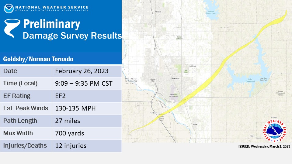
.Goldsby-Norman Tornado...

Rating:                 EF2
Estimated Peak Wind:    130 to 135 mph
Path Length /statute/:  27 miles
Path Width /maximum/:   700 yards
Fatalities:             0
Injuries:               12

Start Date:             02/26/2023
Start Time:             09:09 PM CST
Start Location:         2 NE Cole / McClain County / OK
Start Lat/Lon:          35.12 / -97.55

End Date:               02/26/2023
End Time:               09:35 PM CST
End Location:           2 NE Stella / Cleveland County / OK
End Lat/Lon:            35.34 / -97.18

.Western Oklahoma City Tornado...

Rating:                 EF1
Estimated Peak Wind:    105 to 110 mph
Path Length /statute/:  5 miles
Path Width /maximum/:   500 yards
Fatalities:             0
Injuries:               0

Start Date:             02/26/2023
Start Time:             09:12 PM CST
Start Location:         4 ENE Mustang / Oklahoma County / OK
Start Lat/Lon:          35.42 / -97.66

End Date:               02/26/2023
End Time:               09:18 PM CST
End Location:           2 ESE Bethany / Oklahoma County / OK
End Lat/Lon:            35.49 / -97.61

.Tornado near McLoud...

Rating:                 EF1
Estimated Peak Wind:    95 to 100 mph
Path Length /statute/:  6 miles
Path Width /maximum/:   100 yards
Fatalities:             0
Injuries:               0

Start Date:             02/26/2023
Start Time:             09:42 PM CST
Start Location:         2 SSE Newalla / Cleveland County / OK
Start Lat/Lon:          35.38 / -97.15

End Date:               02/26/2023
End Time:               09:48 PM CST
End Location:           2 NNW Dale / Pottawatomie County / OK
End Lat/Lon:            35.41 / -97.05

.Tornado North of Shawnee...

Rating:                 EF2
Estimated Peak Wind:    125 to 130 mph
Path Length /statute/:  6 miles
Path Width /maximum/:   200 yards
Fatalities:             0
Injuries:               0

Start Date:             02/26/2023
Start Time:             09:45 PM CST
Start Location:         3 SSW Aydelotte / Pottawatomie County / OK
Start Lat/Lon:          35.39 / -96.92

End Date:               02/26/2023
End Time:               09:51 PM CST
End Location:           2 SSE Meeker / Lincoln County / OK
End Lat/Lon:            35.47 / -96.88


&&

EF Scale: The Enhanced Fujita Scale classifies tornadoes into the
following categories:

EF0...Weak......65 to 85 mph
EF1...Weak......86 to 110 mph
EF2...Strong....111 to 135 mph
EF3...Strong....136 to 165 mph
EF4...Violent...166 to 200 mph
EF5...Violent...>200 mph

NOTE:
The information in this statement is preliminary and subject to
change pending final review of the events and publication in
NWS Storm Data.

$$
|
The 13 tornadoes documented for this event is the greatest total of tornadoes to occur during the month of February since officials records began in 1950.
| Tornadoes by Intensity | |||||||
|---|---|---|---|---|---|---|---|
| EFU | EF0 | EF1 | EF2 | EF3 | EF4 | EF5 | Total |
| 1 | 4 | 5 | 3 | 0 | 0 | 0 | 13 |
| Tornado Number |
Date | Time (CST) |
Length of Path (miles) |
Width of Path (yards) |
F-Scale | Killed | Injured | County | Location |
|---|---|---|---|---|---|---|---|---|---|
| 1 | 02/26/2023 | 1908-1914 | 7.5 | 200 | EFU | 0 | 0 | Harmon | 4 NW McKnight - 2.5 SSE Vinson |
| 2 | 02/26/2023 | 1913-1918 | 7 | 500 | EF2 | 1 | 3 | Roger Mills | 2 W Cheyenne - 1 W Strong City |
| 3 | 02/26/2023 | 1913-1918 | 6 | 100 | EF1 | 0 | 0 | Beckham | 5 SW - 2 SE Erick |
| 4 | 02/26/2023 | 1921-1929 | 9 | 75 | EF0 | 0 | 0 | Greer | 8 E Vinson - 5 SW Brinkman |
| 5 | 02/26/2023 | 1945-1954 | 8 | 600 | EF1 | 0 | 0 | Kiowa | 2 E Lone Wolf - 3 NNW Hobart |
| 6 | 02/26/2023 | 2031-2032 | 0.2 | 50 | EF0 | 0 | 0 | Alfalfa | 1 NNW Amorita |
| 7 | 02/26/2023 | 2032-2039 | 5 | 75 | EF0 | 0 | 0 | Caddo | 1 NW Gracemont |
| 8 | 02/26/2023 | 2052-2053 | 0.2 | 75 | EF0 | 0 | 0 | Grady | 4 WSW Minco |
| 9 | 02/26/2023 | 2057-2107 | 11 | 200 | EF1 | 0 | 0 | Grady/ Canadian | 3 W Tuttle - far southwest OKC - 4 WNW Mustang |
| 10 | 02/26/2023 | 2109-2135 | 27 | 700 | EF2 | 0 | 12 | McClain/ Cleveland | 2 NE Cole - Goldsby - Norman (south and east) - 2 NE Stella |
| 11 | 02/26/2023 | 2112-2118 | 5 | 500 | EF1 | 0 | 0 | Oklahoma | western Oklahoma City (4 ENE Mustang - 2 ESE Bethany) |
| 12 | 02/26/2023 | 2142-2148 | 6 | 100 | EF1 | 0 | 0 | Cleveland/ Pottawatomie | 2 SSE Newalla - 2 NNW Dale |
| 13 | 02/26/2023 | 2145-2151 | 6 | 200 | EF2 | 0 | 0 | Pottawatomie/ Lincoln | 3 SSW Aydelotte - 2 SSE Meeker |
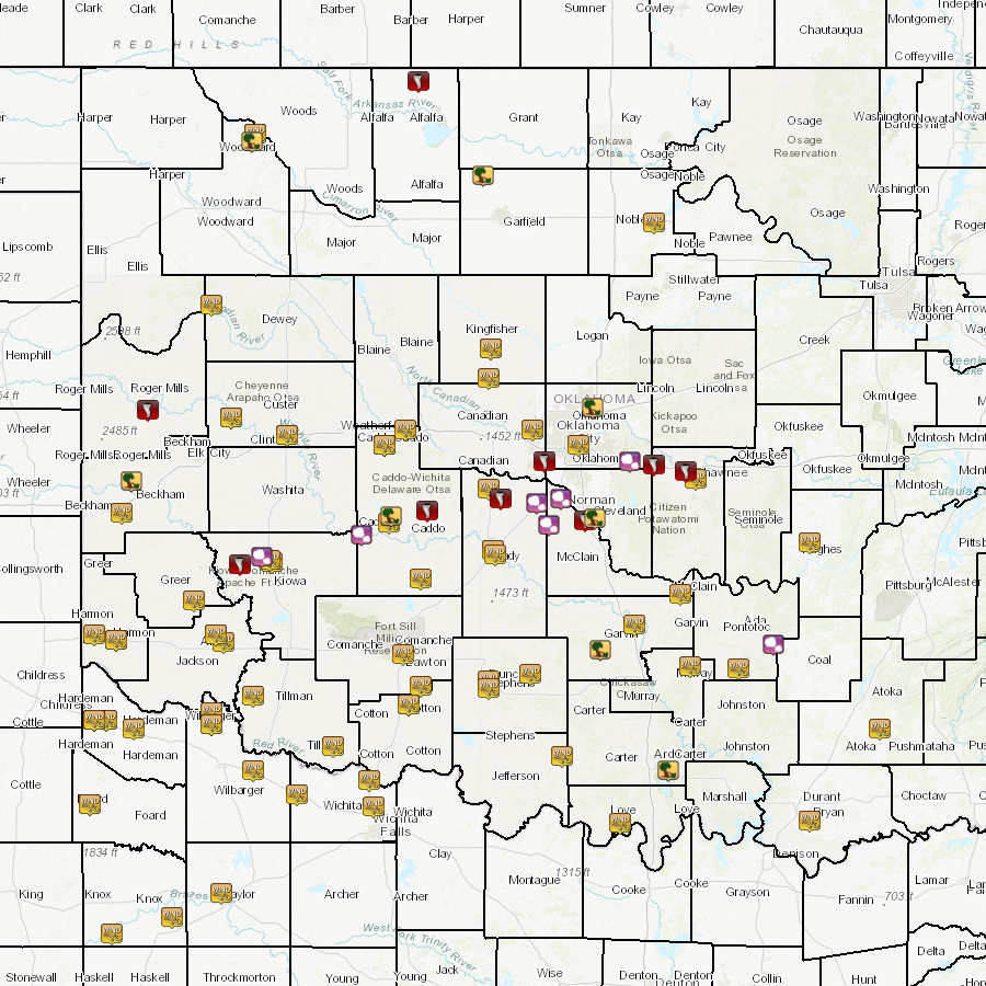
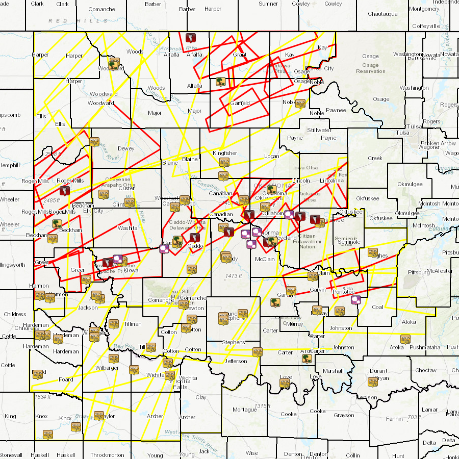
| Report Date |
Report Time (CST) |
Location | County | State | Event Type |
Mag. | Source | Lat. | Lon. | Remark |
|---|---|---|---|---|---|---|---|---|---|---|
| 2/26/2023 | 16:50 | 3 SSW Freedom | Woodward | OK | Non-Tstm Wind Gust | 50 mph | Mesonet | 36.73 | -99.13 | |
| 2/26/2023 | 17:40 | 3 SSW Freedom | Woodward | OK | Non-Tstm Wind Gust | 61 mph | Mesonet | 36.73 | -99.13 | |
| 2/26/2023 | 18:55 | Goodlett | Hardeman | TX | Tstm Wind Gust | 58 mph | Mesonet | 34.34 | -99.88 | |
| 2/26/2023 | 19:00 | 4 ESE Erick | Beckham | OK | Tstm Wind Gust | 78 mph | Mesonet | 35.19 | -99.80 | |
| 2/26/2023 | 19:15 | 3 W Gould | Harmon | OK | Tstm Wind Gust | 75 mph | Mesonet | 34.67 | -99.83 | |
| 2/26/2023 | 19:15 | Cheyenne | Roger Mills | OK | Tstm Wind Damage | Emergency Mngr | 35.61 | -99.67 | 2 manufactured homes destroyed. 1 state barn damaged. Time estimated based on radar. | |
| 2/26/2023 | 19:15 | Cheyenne | Roger Mills | OK | Tornado | NWS Employee | 35.61 | -99.67 | Tornado confirmed from a combination of spotter reports and radar. Damage survey will be conducted in the area on 2/28/2023. | |
| 2/26/2023 | 19:21 | 6 W Sayre | Beckham | OK | Tstm Wind Damage | Public | 35.32 | -99.75 | Powerlines reported down along Highway 152 west of Sayre. Time estimated by radar. | |
| 2/26/2023 | 19:30 | Goodlett | Hardeman | TX | Tstm Wind Gust | 71 mph | Mesonet | 34.34 | -99.88 | |
| 2/26/2023 | 19:35 | 2 NNW Hester | Greer | OK | Tstm Wind Gust | 62 mph | Mesonet | 34.83 | -99.44 | |
| 2/26/2023 | 19:39 | Quanah | Hardeman | TX | Tstm Wind Gust | 64 mph | Broadcast Media | 34.30 | -99.74 | |
| 2/26/2023 | 19:40 | Comanche Springs | Foard | TX | Tstm Wind Gust | 59 mph | Mesonet | 33.99 | -99.96 | |
| 2/26/2023 | 19:45 | 2 ESE Lone Wolf | Kiowa | OK | Tornado | NWS Employee | 34.98 | -99.21 | Beginning of tornado path; Based on radar estimate and beginning of damage reports; Traveled NE into Hobart. | |
| 2/26/2023 | 19:49 | Altus Air Force Base | Jackson | OK | Tstm Wind Gust | 59 mph | ASOS | 34.66 | -99.29 | |
| 2/26/2023 | 19:53 | Clinton | Custer | OK | Tstm Wind Gust | 70 mph | ASOS | 35.51 | -98.97 | |
| 2/26/2023 | 19:55 | 3 N Altus | Jackson | OK | Tstm Wind Gust | 62 mph | ASOS | 34.69 | -99.33 | |
| 2/26/2023 | 19:55 | 4 SE Hobart | Kiowa | OK | Tstm Wind Gust | 77 mph | Mesonet | 34.99 | -99.05 | |
| 2/26/2023 | 19:58 | 3 SE Hobart | Kiowa | OK | Tstm Wind Gust | 73 mph | ASOS | 35.00 | -99.06 | |
| 2/26/2023 | 20:01 | Clinton | Custer | OK | Tstm Wind Gust | 77 mph | ASOS | 35.51 | -98.97 | |
| 2/26/2023 | 20:05 | 4 ENE Odell | Wilbarger | TX | Tstm Wind Gust | 63 mph | Mesonet | 34.37 | -99.35 | |
| 2/26/2023 | 20:09 | 1 S Hobart | Kiowa | OK | Hail | 1.75 in. | Trained Spotter | 35.01 | -99.10 | Spotter Network report. |
| 2/26/2023 | 20:10 | 4 S Tipton | Tillman | OK | Tstm Wind Gust | 69 mph | Mesonet | 34.44 | -99.14 | |
| 2/26/2023 | 20:10 | 3 NW Knox City | Knox | TX | Tstm Wind Gust | 57 mph | Mesonet | 33.45 | -99.85 | |
| 2/26/2023 | 20:15 | 3 N Altus | Jackson | OK | Tstm Wind Gust | 63 mph | ASOS | 34.69 | -99.33 | |
| 2/26/2023 | 20:16 | Carnegie | Caddo | OK | Hail | 1.00 in. | Trained Spotter | 35.10 | -98.60 | |
| 2/26/2023 | 20:20 | 4 NNW Goree | Knox | TX | Tstm Wind Gust | 61 mph | ASOS | 33.52 | -99.55 | |
| 2/26/2023 | 20:20 | 2 ESE Fort Cobb Reservoir | Caddo | OK | Tstm Wind Damage | Amateur Radio | 35.18 | -98.45 | Wind damage to home and outbuilding | |
| 2/26/2023 | 20:26 | Oklaunion | Wilbarger | TX | Tstm Wind Gust | 70 mph | Emergency Mngr | 34.13 | -99.14 | |
| 2/26/2023 | 20:30 | 1 S Bridgeport | Caddo | OK | Tstm Wind Gust | 80 mph | Broadcast Media | 35.53 | -98.38 | |
| 2/26/2023 | 20:30 | 3 SSE Fort Cobb Reservoir | Caddo | OK | Tstm Wind Gust | 66 mph | Mesonet | 35.15 | -98.46 | |
| 2/26/2023 | 20:30 | 7 W Hinton | Caddo | OK | Tstm Wind Gust | 66 mph | Mesonet | 35.47 | -98.48 | |
| 2/26/2023 | 20:31 | 1 NW Amorita | Alfalfa | OK | Tornado | Public | 36.94 | -98.31 | Farm shed destroyed. Time based on radar data. | |
| 2/26/2023 | 20:35 | 7 W Hinton | Caddo | OK | Tstm Wind Gust | 68 mph | Mesonet | 35.47 | -98.48 | |
| 2/26/2023 | 20:35 | 3 NW Seymour | Baylor | TX | Tstm Wind Gust | 66 mph | ASOS | 33.62 | -99.30 | |
| 2/26/2023 | 20:35 | 3 SSE Stecker | Caddo | OK | Tstm Wind Gust | 64 mph | Mesonet | 34.92 | -98.30 | |
| 2/26/2023 | 20:36 | Electra | Wichita | TX | Tstm Wind Gust | 62 mph | Trained Spotter | 34.03 | -98.92 | |
| 2/26/2023 | 20:40 | 3 W Grandfield | Tillman | OK | Tstm Wind Gust | 69 mph | Mesonet | 34.23 | -98.74 | |
| 2/26/2023 | 20:45 | 3 W Goodlett | Hardeman | TX | Tstm Wind Gust | 64 mph | ASOS | 34.34 | -99.94 | |
| 2/26/2023 | 20:46 | Lawton | Comanche | OK | Tstm Wind Gust | 72 mph | Trained Spotter | 34.61 | -98.39 | |
| 2/26/2023 | 20:52 | 5 NE Pocasset | Grady | OK | Tornado | NWS Employee | 35.25 | -97.90 | Beginning of tornado path; Based on radar estimate and beginning of damage reports. | |
| 2/26/2023 | 20:55 | Chickasha | Grady | OK | Hail | 1.00 in. | Trained Spotter | 35.04 | -97.94 | |
| 2/26/2023 | 20:55 | Burkburnett | Wichita | TX | Tstm Wind Gust | 59 mph | Trained Spotter | 34.09 | -98.56 | |
| 2/26/2023 | 20:55 | 2 SSE Chickasha | Grady | OK | Tstm Wind Gust | 65 mph | Mesonet | 35.02 | -97.93 | |
| 2/26/2023 | 20:55 | 4 NW Walters | Cotton | OK | Tstm Wind Gust | 60 mph | Mesonet | 34.40 | -98.36 | |
| 2/26/2023 | 20:56 | Chickasha | Grady | OK | Tstm Wind Gust | 71 mph | Trained Spotter | 35.04 | -97.94 | |
| 2/26/2023 | 21:00 | 2 SSW Minco | Grady | OK | Tstm Wind Gust | 59 mph | Mesonet | 35.29 | -97.96 | |
| 2/26/2023 | 21:00 | 4 NW Walters | Cotton | OK | Tstm Wind Gust | 65 mph | Mesonet | 34.40 | -98.36 | |
| 2/26/2023 | 21:00 | 5 WSW Hulen | Comanche | OK | Tstm Wind Gust | 85 mph | Public | 34.48 | -98.30 | Time is radar estimated. |
| 2/26/2023 | 21:01 | 2 WNW Sheppard AFB | Wichita | TX | Tstm Wind Gust | 59 mph | Trained Spotter | 33.98 | -98.54 | |
| 2/26/2023 | 21:05 | Bridge Creek | Grady | OK | Hail | 1.50 in. | Public | 35.23 | -97.72 | Time estimated based on radar. |
| 2/26/2023 | 21:05 | Blanchard | McClain | OK | Hail | 1.25 in. | Public | 35.14 | -97.66 | Time is radar estimated. |
| 2/26/2023 | 21:07 | 3 ENE Mustang | Canadian | OK | Tornado | NWS Employee | 35.40 | -97.68 | Beginning of tornado path; Based on radar estimate and beginning of damage reports. | |
| 2/26/2023 | 21:09 | Hillsdale | Garfield | OK | Tstm Wind Damage | Emergency Mngr | 36.56 | -97.99 | Roof removed from trailer in Hillsdale. Time estimated by radar. | |
| 2/26/2023 | 21:10 | Duncan | Stephens | OK | Tstm Wind Gust | 57 mph | ASOS | 34.50 | -97.96 | |
| 2/26/2023 | 21:10 | 2 S Duncan | Stephens | OK | Tstm Wind Gust | 66 mph | ASOS | 34.47 | -97.96 | |
| 2/26/2023 | 21:12 | Newcastle | McClain | OK | Hail | 1.00 in. | Fire Dept/Rescue | 35.25 | -97.60 | |
| 2/26/2023 | 21:15 | 1 W Kingfisher | Kingfisher | OK | Tstm Wind Gust | 57 mph | Mesonet | 35.86 | -97.95 | |
| 2/26/2023 | 21:15 | 1 N Ringling | Jefferson | OK | Tstm Wind Gust | 60 mph | Mesonet | 34.19 | -97.59 | |
| 2/26/2023 | 21:15 | 3 SE Edmond | Oklahoma | OK | Tstm Wind Damage | Emergency Mngr | 35.62 | -97.44 | Three sections of fence down (2 posts were already rotten). Time estimated. | |
| 2/26/2023 | 21:16 | Oklahoma City | Oklahoma | OK | Tstm Wind Gust | 59 mph | ASOS | 35.47 | -97.51 | |
| 2/26/2023 | 21:18 | 1 N Goldsby | McClain | OK | Tornado | NWS Employee | 35.16 | -97.48 | Beginning of tornado path; time radar estimate; Based on beginning damage reports; Tornado traveled NE into Norman. | |
| 2/26/2023 | 21:19 | 1 NE Okarche | Kingfisher | OK | Tstm Wind Gust | 59 mph | Trained Spotter | 35.74 | -97.96 | |
| 2/26/2023 | 21:20 | 2 N Yukon | Canadian | OK | Tstm Wind Gust | 58 mph | Mesonet | 35.53 | -97.74 | |
| 2/26/2023 | 21:25 | 1 W Kingfisher | Kingfisher | OK | Tstm Wind Gust | 60 mph | Mesonet | 35.86 | -97.95 | |
| 2/26/2023 | 21:25 | 7 NW Velma | Stephens | OK | Tstm Wind Gust | 77 mph | Mesonet | 34.53 | -97.75 | |
| 2/26/2023 | 21:30 | 3 NE Goldsby | Cleveland | OK | Tstm Wind Damage | 0 | NWS Employee | 35.17 | -97.43 | 30-ft tall large tree over 12-in diameter uprooted. Backyard fence damaged and minor roof damage to home. |
| 2/26/2023 | 21:36 | 6 NNW Stella | Oklahoma | OK | Hail | 1.00 in. | Trained Spotter | 35.40 | -97.25 | |
| 2/26/2023 | 21:40 | Elmore City | Garvin | OK | Tstm Wind Damage | Utility Company | 34.63 | -97.40 | Damage to trees; car port tops; Some shingles removed from roofs; Metal shop overturned; Roof removed from old shop. Time estimated from radar. | |
| 2/26/2023 | 21:42 | 4 SSW Mcloud | Pottawatomie | OK | Tornado | NWS Employee | 35.39 | -97.13 | Beginning of tornado path; Based on radar estimate. | |
| 2/26/2023 | 21:47 | 3 NW Shawnee | Pottawatomie | OK | Tornado | NWS Employee | 35.36 | -96.97 | Beginning of tornado path; Based on radar estimate and beginning of damage reports. | |
| 2/26/2023 | 21:55 | 1 SSW Pauls Valley | Garvin | OK | Tstm Wind Gust | 59 mph | Mesonet | 34.73 | -97.23 | |
| 2/26/2023 | 21:55 | Shawnee | Pottawatomie | OK | Tstm Wind Gust | 61 mph | Mesonet | 35.33 | -96.92 | |
| 2/26/2023 | 22:00 | 7 SW Sooner Lake | Noble | OK | Tstm Wind Gust | 59 mph | Mesonet | 36.37 | -97.13 | |
| 2/26/2023 | 22:00 | 7 W Hinton | Caddo | OK | Non-Tstm Wind Gust | 58 mph | Mesonet | 35.47 | -98.48 | |
| 2/26/2023 | 22:10 | 3 ESE Byars | McClain | OK | Tstm Wind Gust | 60 mph | Mesonet | 34.86 | -97.00 | |
| 2/26/2023 | 22:15 | 4 NNE Sulphur | Murray | OK | Tstm Wind Gust | 69 mph | Mesonet | 34.56 | -96.95 | |
| 2/26/2023 | 22:15 | 3 W Goodlett | Hardeman | TX | Non-Tstm Wind Gust | 59 mph | ASOS | 34.34 | -99.94 | |
| 2/26/2023 | 22:25 | 6 SW Fittstown | Pontotoc | OK | Tstm Wind Gust | 86 mph | Mesonet | 34.55 | -96.71 | |
| 2/26/2023 | 22:32 | 5 NNE Lake Murray | Carter | OK | Tstm Wind Damage | Broadcast Media | 34.13 | -97.06 | Sheet metal roof removed from outbuilding. Time estimated by radar. | |
| 2/26/2023 | 22:33 | Stonewall | Pontotoc | OK | Hail | 1.75 in. | Emergency Mngr | 34.65 | -96.53 | |
| 2/26/2023 | 22:35 | Burneyville | Love | OK | Non-Tstm Wind Gust | 59 mph | Mesonet | 33.91 | -97.30 | |
| 2/26/2023 | 22:40 | 3 W Goodlett | Hardeman | TX | Non-Tstm Wind Gust | 63 mph | ASOS | 34.34 | -99.94 | |
| 2/26/2023 | 22:45 | 3 W Gould | Harmon | OK | Non-Tstm Wind Gust | 60 mph | Mesonet | 34.67 | -99.83 | |
| 2/26/2023 | 22:45 | 3 W Goodlett | Hardeman | TX | Non-Tstm Wind Gust | 69 mph | ASOS | 34.34 | -99.94 | |
| 2/26/2023 | 22:50 | 3 W Goodlett | Hardeman | TX | Non-Tstm Wind Gust | 77 mph | ASOS | 34.34 | -99.94 | |
| 2/26/2023 | 22:55 | 3 ESE Holdenville | Hughes | OK | Tstm Wind Gust | 61 mph | Mesonet | 35.07 | -96.35 | |
| 2/26/2023 | 23:10 | 2 WNW Foss Reservoir | Custer | OK | Non-Tstm Wind Gust | 57 mph | Mesonet | 35.58 | -99.25 | |
| 2/26/2023 | 23:20 | 4 WNW Camargo | Dewey | OK | Non-Tstm Wind Gust | 57 mph | Mesonet | 36.04 | -99.35 | |
| 2/26/2023 | 23:35 | Comanche Springs | Foard | TX | Non-Tstm Wind Gust | 66 mph | ASOS | 33.99 | -99.96 | |
| 2/26/2023 | 23:35 | 5 ESE Calera | Bryan | OK | Tstm Wind Gust | 58 mph | Mesonet | 33.92 | -96.35 | |
| 2/26/2023 | 23:35 | 1 WNW Lane | Atoka | OK | Tstm Wind Gust | 58 mph | Mesonet | 34.30 | -96.00 | |
| 2/26/2023 | 23:35 | 2 WNW Foss Reservoir | Custer | OK | Non-Tstm Wind Gust | 60 mph | Mesonet | 35.58 | -99.25 | |
| 2/26/2023 | 23:50 | 4 ESE Odell | Wilbarger | TX | Non-Tstm Wind Gust | 58 mph | ASOS | 34.32 | -99.35 | |
| 2/26/2023 | 23:55 | 4 ESE Odell | Wilbarger | TX | Non-Tstm Wind Gust | 60 mph | ASOS | 34.32 | -99.35 |
These photos show EF-1/EF-2 damage was caused by the "Cheyenne-Strong City" tornado on February 26, 2023. A survey of the area was conducted on February 28, 2023.
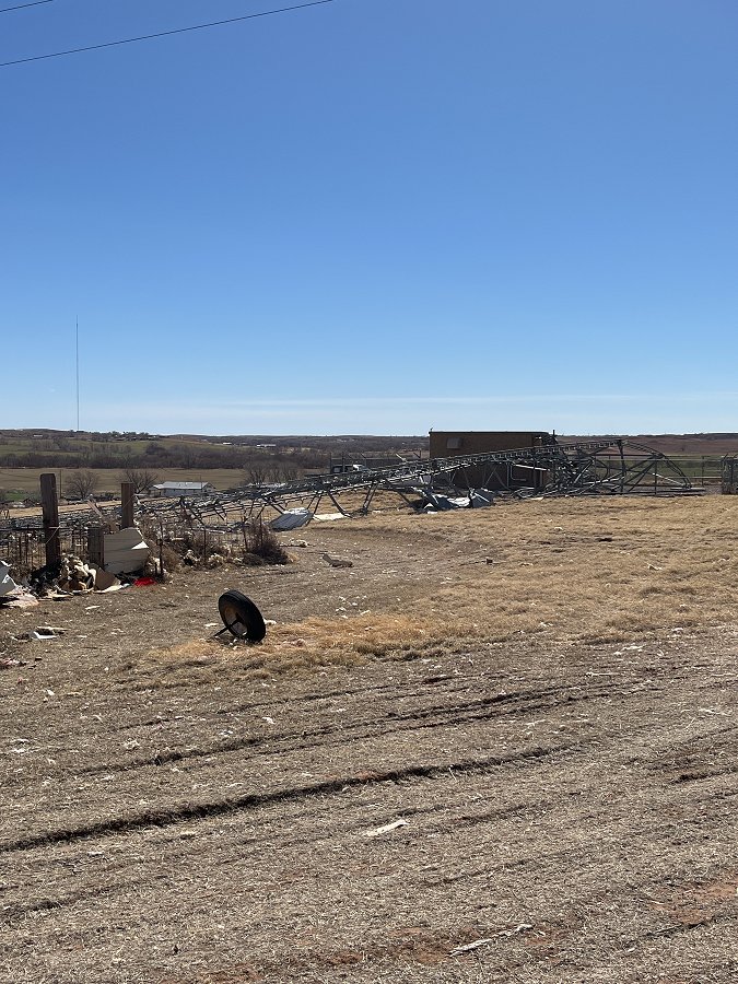 Photo 1: This photo shows a collapsed cell phone tower on the west side of Cheyenne, OK in Roger Mills County. This damage was rated EF-2. |
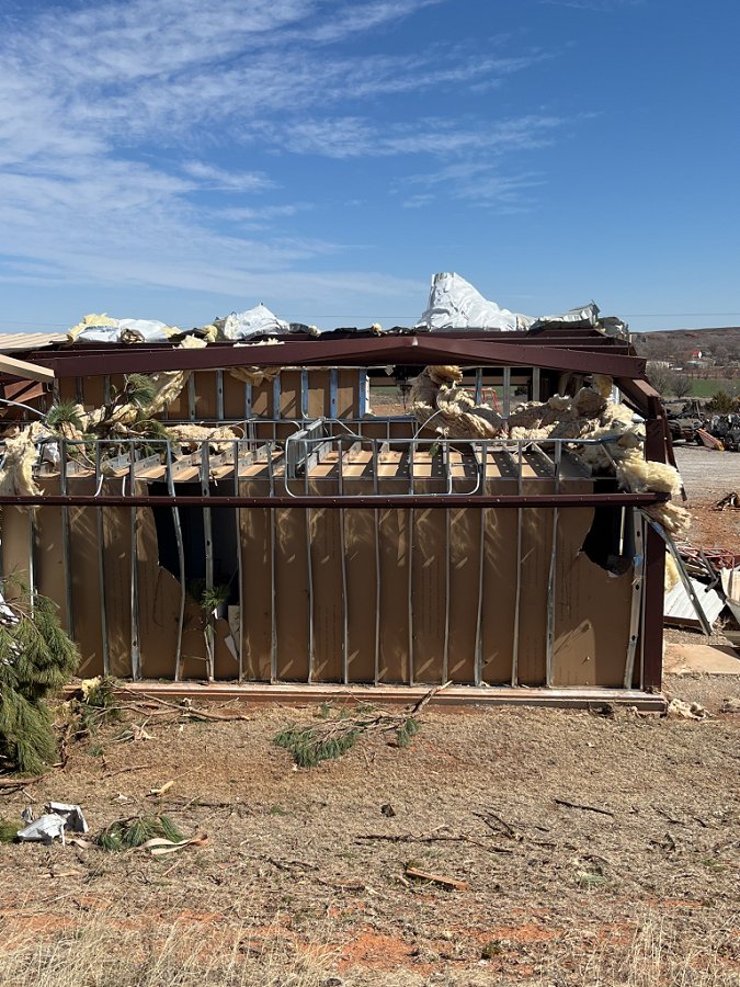 Photo 2: This photo shows EF-2 damage to a metal storage building near the Washita Battlefield Visitor Center and just west of Cheyenne, OK in Roger Mills County. The roof purlins buckled in this metal building. |
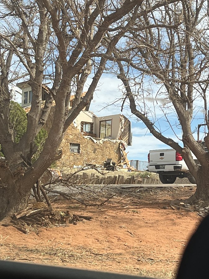 Photo 3: This photo shows EF-2 damage to the second story of a house on the west side of Cheyenne, OK in Roger Mills County. Part of the roof and second story wall of the house are missing. |
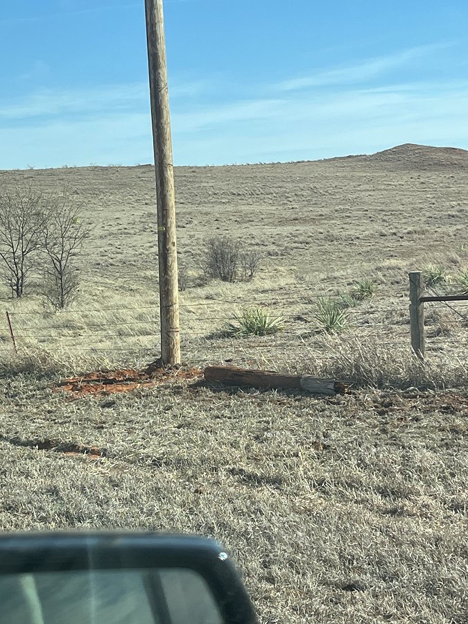 Photo 4: This photo shows EF-1 damage to a broken utility pole just west of Strong City along OK State Highway 33 in Roger Mills County. The replacement utility pole had already been installed by the time the survey was conducted. |
Severe Weather Update - 1:00 pm CST, February 26, 2023
Severe Weather Update - 4:00 am CST, February 26, 2023
Severe Weather Update - 10:30 pm CST, February 25, 2023
Severe Weather Update - February 25, 2023
Severe Weather Update - February 24, 2023