
Heat expands across the Desert Southwest, Plains, Mississippi Valley and Midwest into Monday. Fire weather concerns continue for portions of the Intermountain West. Active monsoonal moisture fuels thunderstorms over the Southwest with possible flash flooding. Tropical cyclone Fausto in the Pacific, should weaken as it approaches Hawaii; Dangerous surf, swells and rip currents are expected. Read More >
NWS Norman NWPS Hydrograph Monitor Page
**ABRFC Forecast Precipitation** **WGRFC Forecast Precipitation**
| SALT FORK ARKANSAS RIVER (AND TRIBUTARIES) | |||
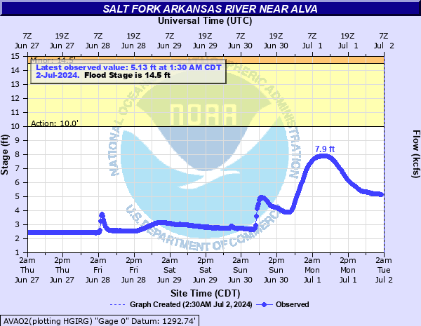 AVAO2 - Salt Fork Arkansas River near Alva, OK |
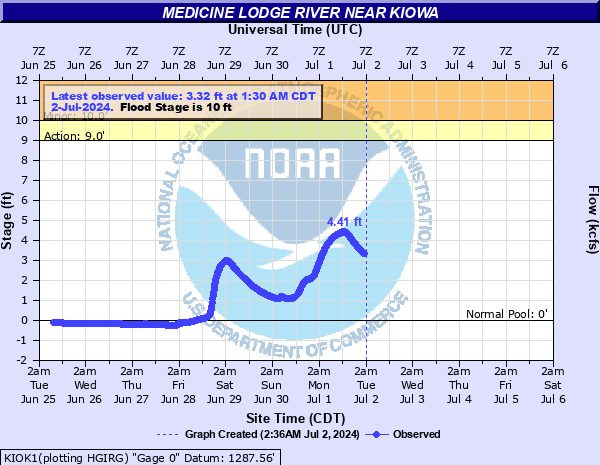 KIOK1 - Medine Lodge River near Kiowa, KS (NWS Dodge City) |
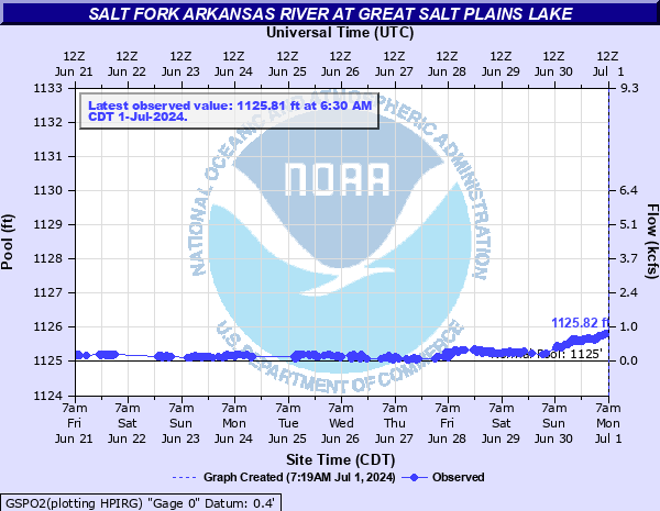 GSPO2 - Salt Fork Arkansas River at Great Salt Plains Reservoir near Jet, OK |
|
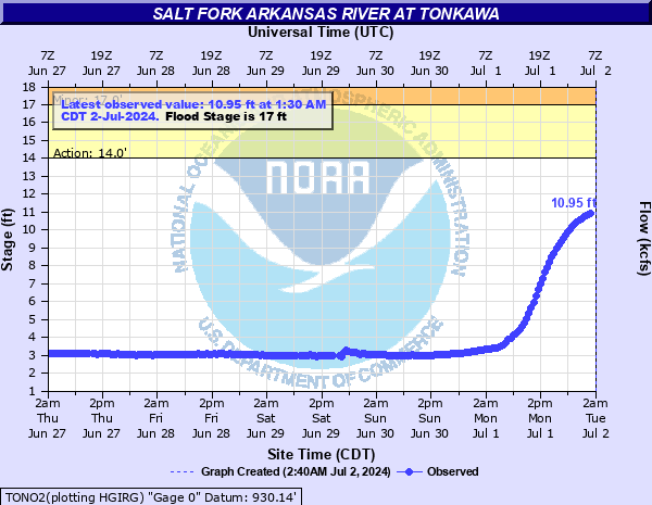 TONO2 - Salt Fork Arkansas River near Tonkawa, OK |
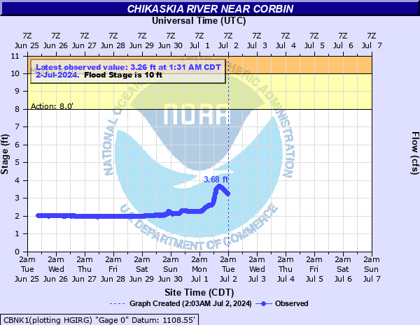 CBNK1 - Chikaskia River near Corbin, KS (NWS Wichita) |
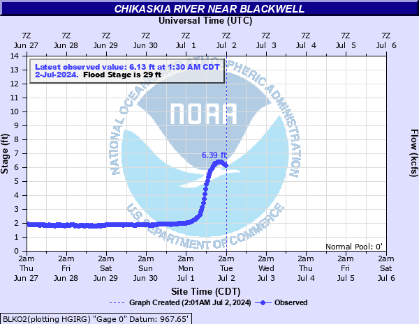 BLKO2 - Chikaskia River near Blackwell, OK |
|
| CIMARRON RIVER (AND TRIBUTARIES) | |||
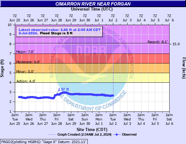 FRGO2 - Cimarron River near Forgan, OK (NWS Dodge City) |
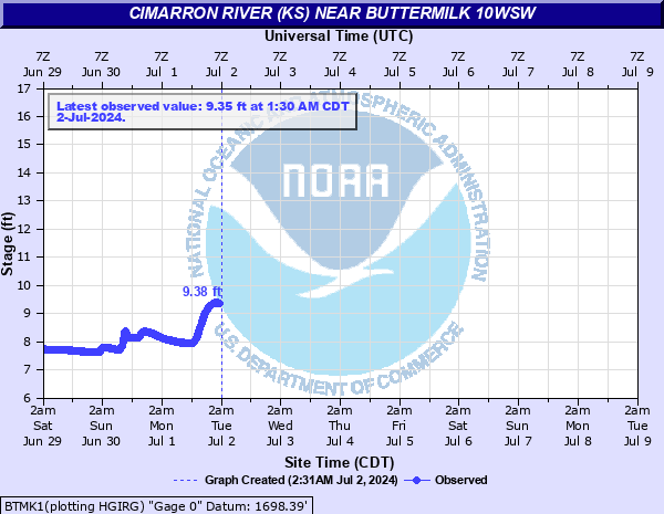 BTMK1 - Cimarron River near Buttermilk, KS (NWS Dodge City) |
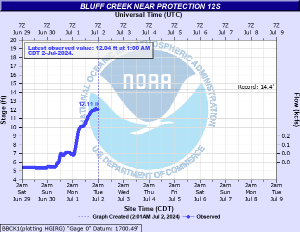 BBCK1 - Bluff Creek near Buttermilk, KS (NWS Dodge City) |
|
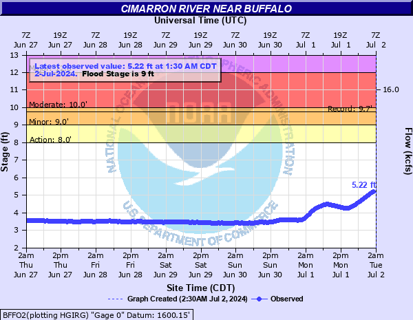 BFFO2 - Cimarron River near Buffalo, OK |
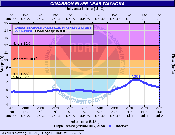 WANO2 - Cimarron River near Waynoka, OK |
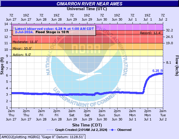 AMCO2 - Cimarron River near Ames, OK |
|
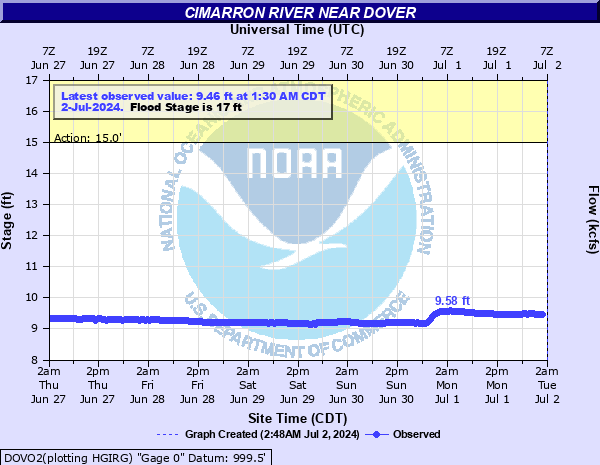 DOVO2 - Cimarron River near Dover, OK |
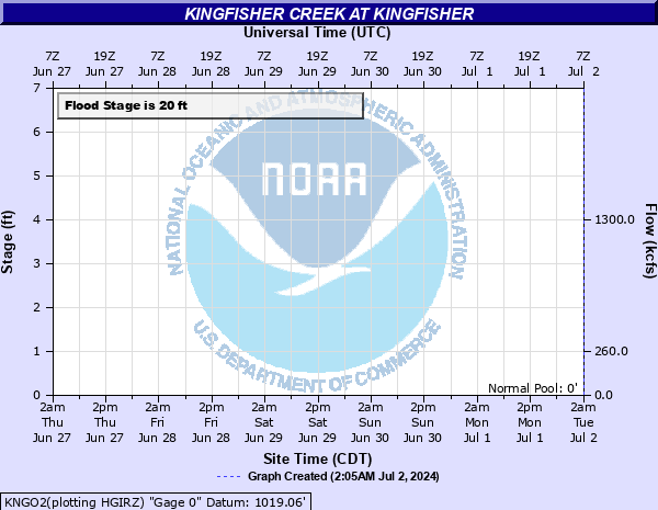 KNGO2 - Kingfisher Creek at Kingfisher, OK |
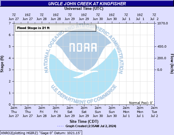 KNRO2 - Uncle John Creek at Kingfisher, OK |
|
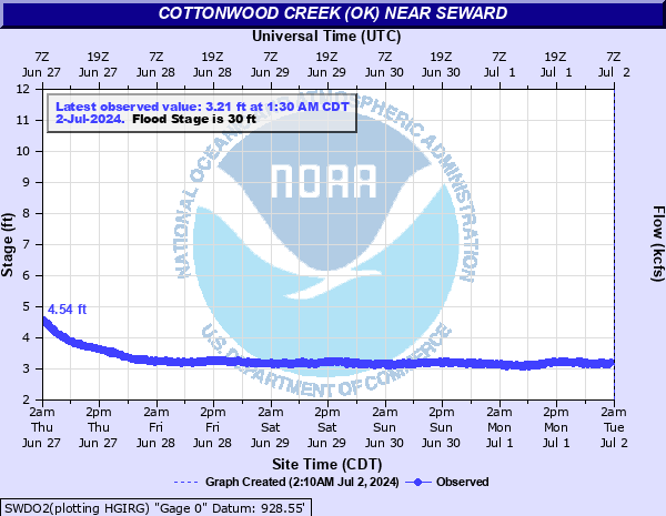 SWDO2 - Cottonwood Creek near Seward, OK |
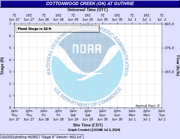 GUCO2 - Cottonwood Creek at Guthrie, OK |
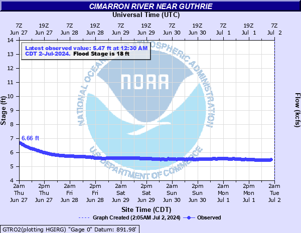 GTRO2- Cimarron River near Guthrie, OK |
|
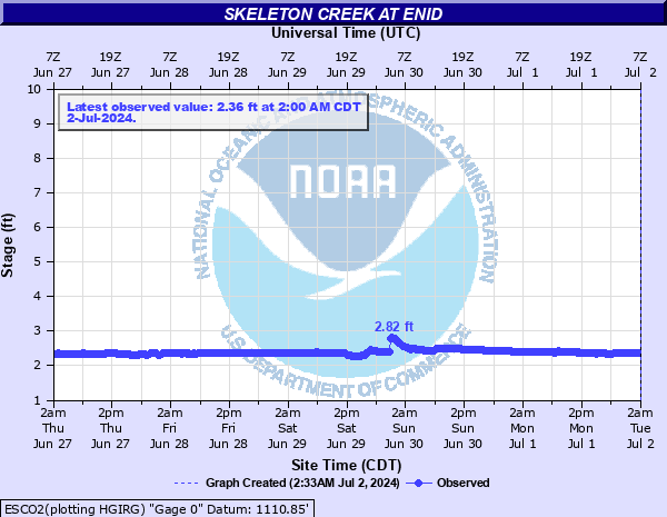 ESCO2 - Skeleton Creek at Enid, OK |
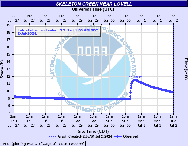 LVLO2 - Skeleton Creek near Lovell, OK |
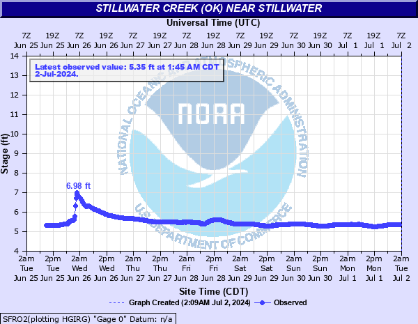 SFRO2 - Stillwater Creek near Stillwater, OK |
|
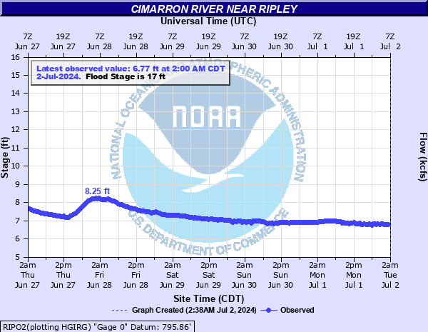 RIPO2 - Cimarron River near Ripley, OK |
|||
| NORTH CANADIAN RIVER (AND TRIBUTARIES) | |||
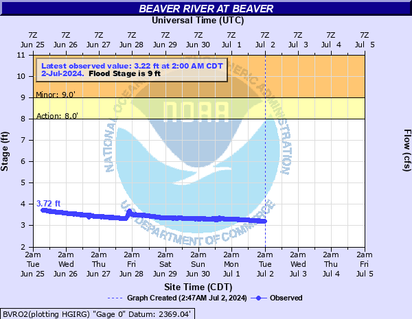 BVRO2 - Beaver River at Beaver, OK (NWS Amarillo) |
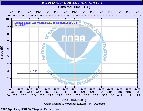 FSPO2 - Beaver River near Fort Supply, OK |
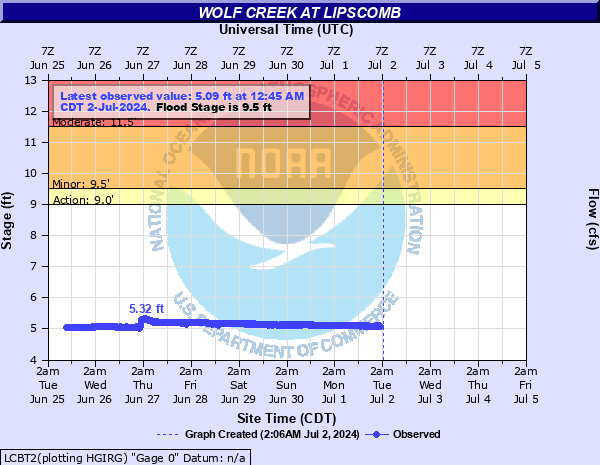 LCBT2 - Wolf Creek at Lipscomb, TX (NWS Amarillo) |
|
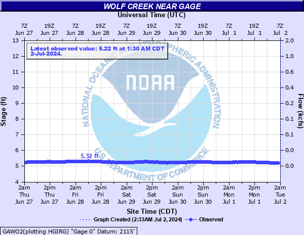 GAWO2 - Wolf Creek near Gage, OK |
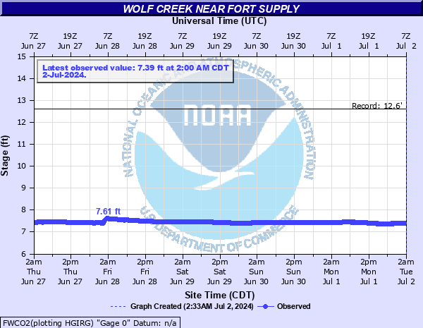 FWCO2 - Wolf Creek near Fort Supply, OK |
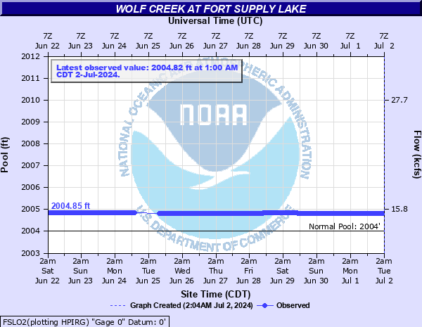 FSLO2 - Wolf Creek at Fort Supply Lake near Fort Supply, OK |
|
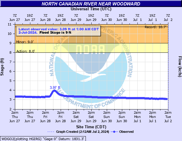 WDGO2 - North Canadian River near Woodward, OK |
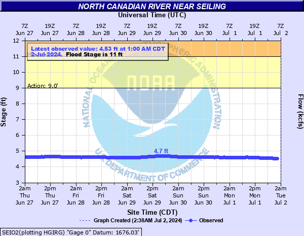 SEIO2 - North Canadian River near Seiling, OK |
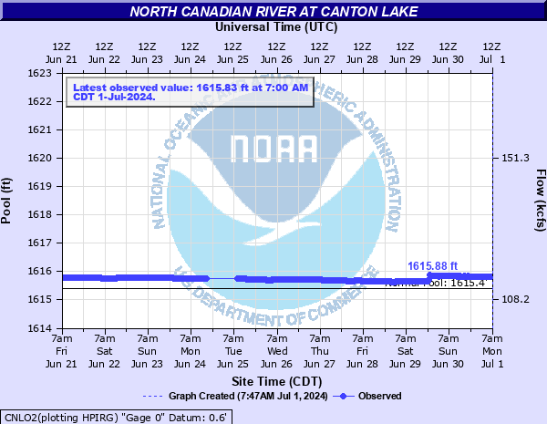 CNLO2 - North Canadian River at Canton Laker near Canton, OK |
|
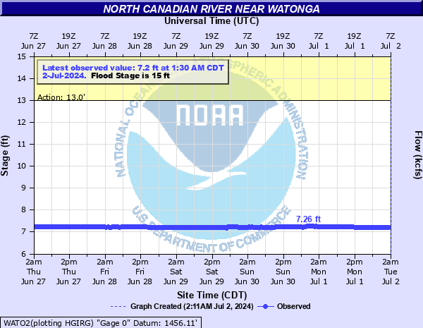 WATO2 - North Canadian River near Watonga, OK |
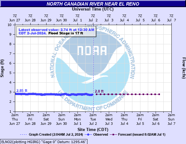 ELNO2 - North Canadian River near El Reno, OK |
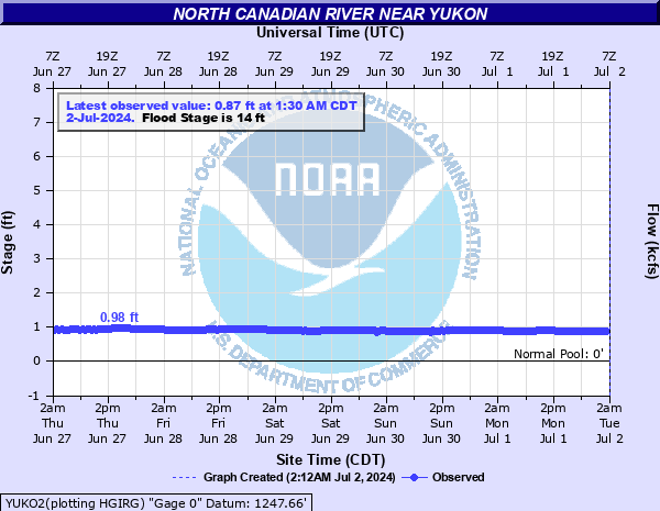 YUKO2- North Canadian River near Yukon, OK |
|
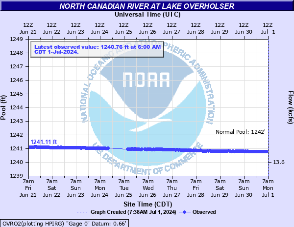 OVRO2 - North Canadian River at Laker Overholser near OKC |
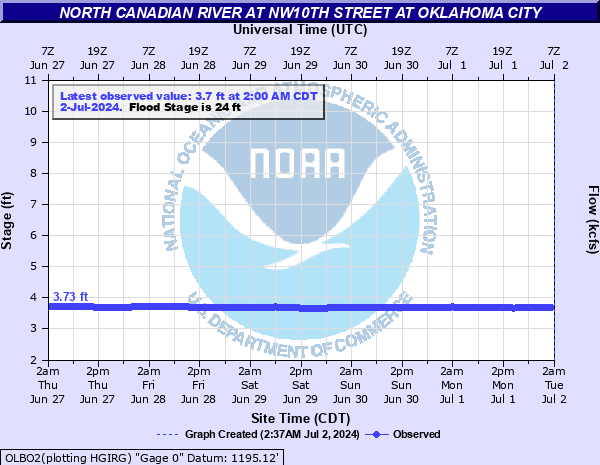 OLBO2 - North Canadian River at NW 10th Street at OKC |
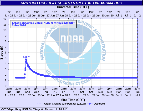 OCCO2 - Crutcho Creek at SE 50th Street at OKC |
|
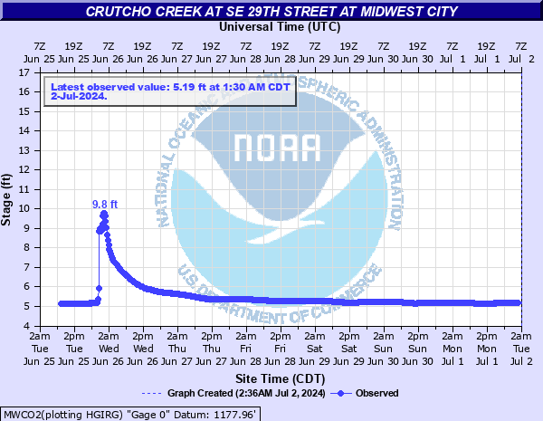 MWCO2 - Crutcho Creek at SE 29th Street at Midwest City |
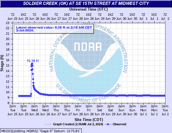 MSCO2 - Soldier Creek near SE 15th Street at Midwest City |
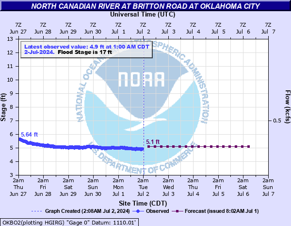 OKBO2 - North Canadian River at Britton Road at OKC |
|
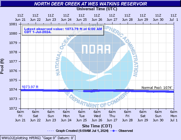 WWLO2 - North Deer Creek at Wes Watkins Reservoir near McLoud, OK |
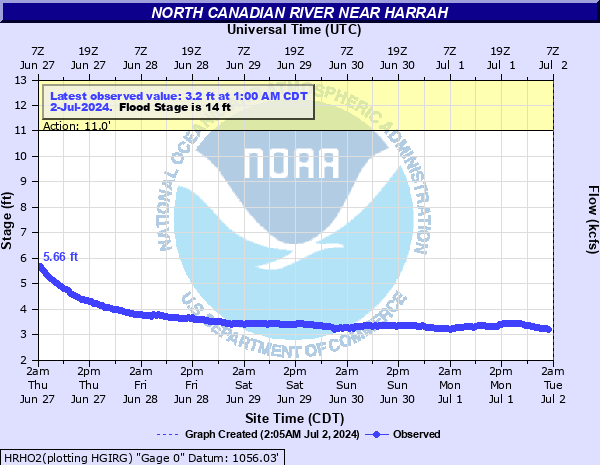 HRHO2 - North Canadian River near Harrah, OK |
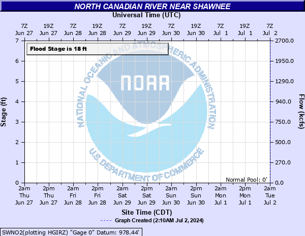 SWNO2 - North Canadian River near Shawnee, OK |
|
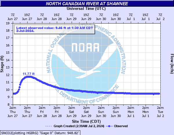 SNCO2 - North Canadian River at Shawnee, OK |
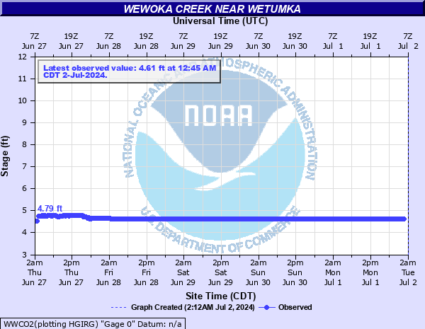 WWCO2 - Wewoka Creek near Wetumka, OK |
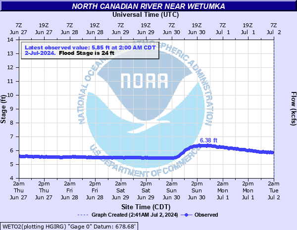 WETO2 - North Canadian River near Wetumka, OK |
|
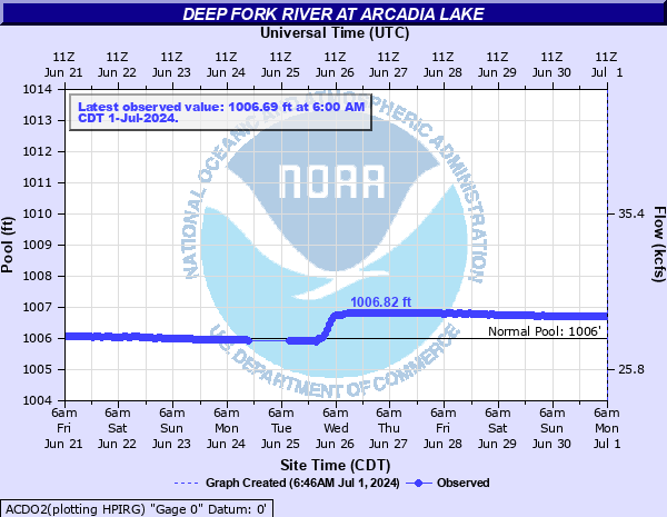 ACDO2 - Deep Fork River at Arcadia Lake at Arcadia, OK |
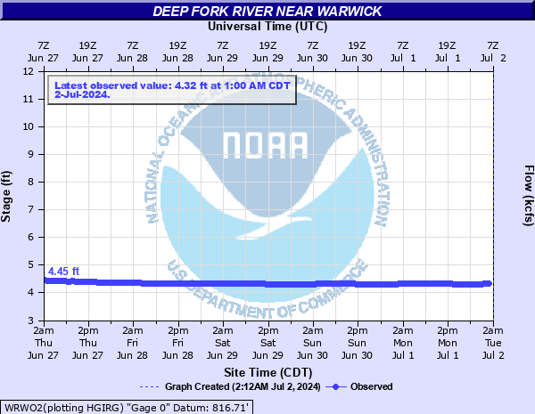 WRWO2 - Deep Fork River near Warwick, OK |
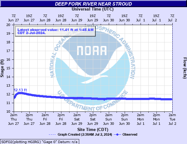 SDFO2 - Deep Fork River near Stroud, OK |
|
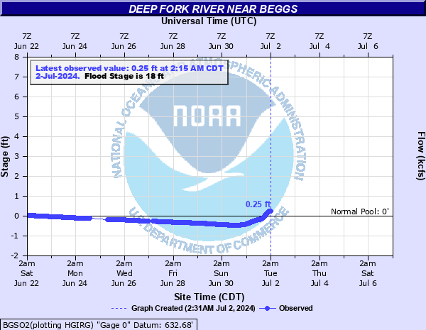 BGSO2 - Deep Fork River near Beggs, OK (NWS Tulsa) |
|||
| CANADIAN RIVER (AND TRIBUTARIES) | |||
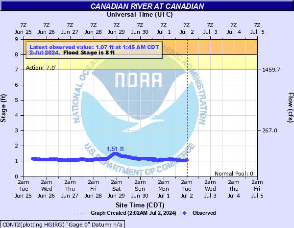 CDNT2 - Canadian River near Canadian, TX (NWS Amarillo) |
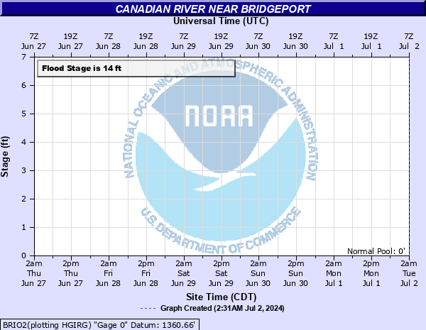 BRIO2 - Canadian River near Bridgeport, OK |
 CCRO2 - Canadian River near Cogar, OK |
|
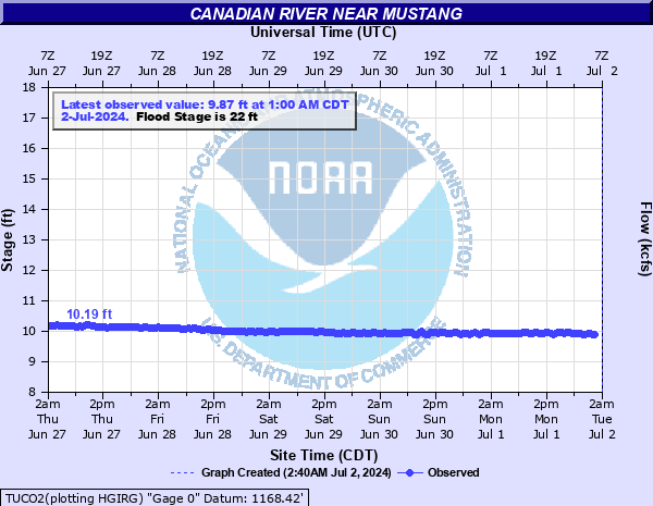 TUCO2 - Canadian River near Mustang, OK |
 NRCO2- Canadian River at Norman, OK |
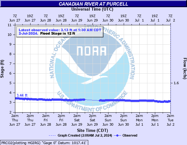 PRCO2 - Canadian River at Purcell, OK |
|
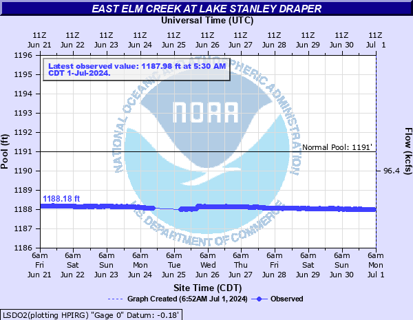 LSDO2 - East Elm Creek at Lake Stanley Draper near OKC |
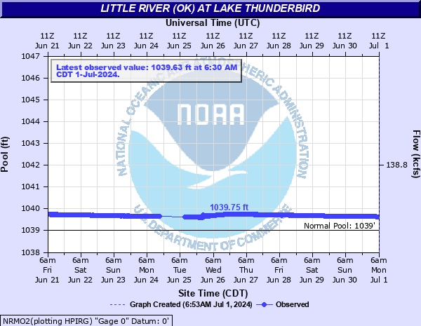 NRMO2 - Little River at Lake Thunderbird near Norman, OK |
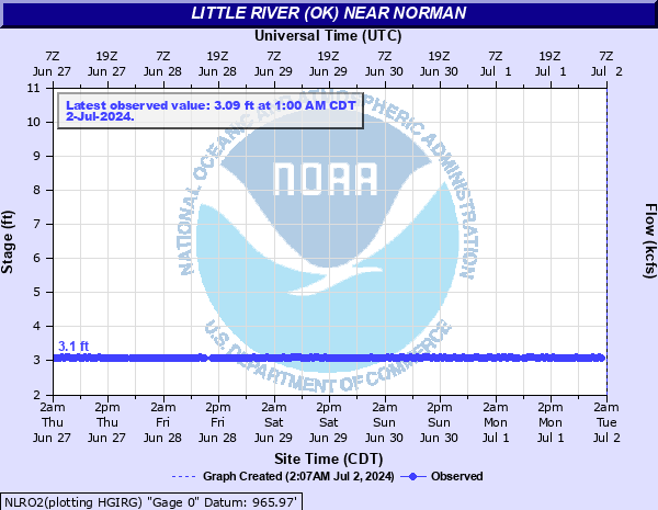 NLRO2 - Little River near Norman, OK |
|
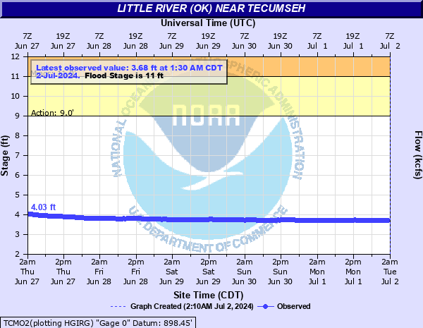 TCMO2 - Little River near Tecumseh, OK |
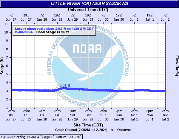 SASO2 - Little River near Sasakwa, OK |
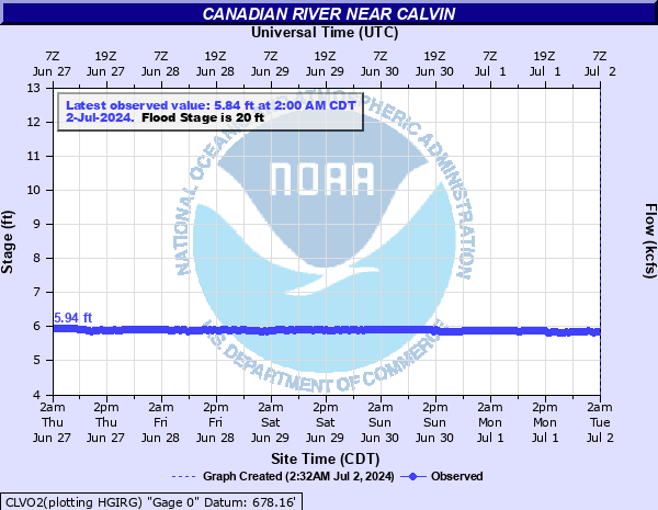 CLVO2 - Canadian River near Calvin, OK |
|
| SALT FORK OF THE RED RIVER | |||
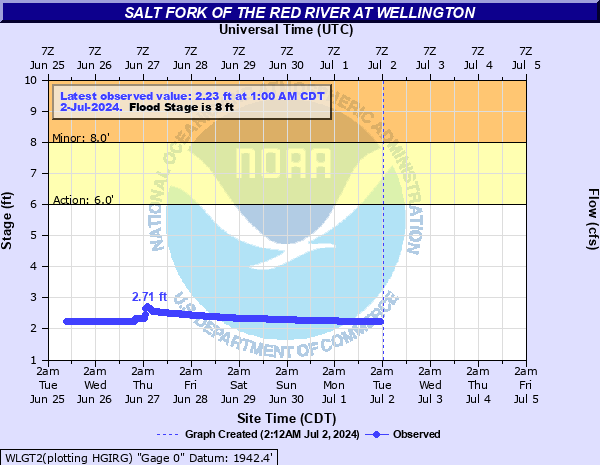 WLGT2 - Salt Fork of the Red River near Wellington, TX (NWS Amarillo) |
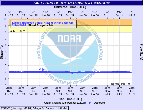 MGMO2 - Salt Fork of the Red River near Mangum |
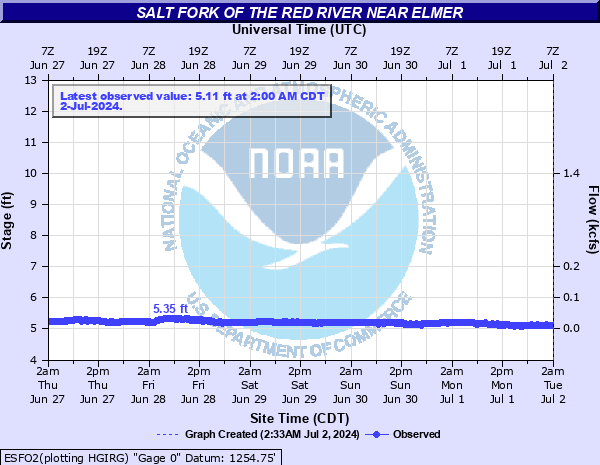 ESFO2 - Salt Fork of the Red River near Elmer, OK |
|
| NORTH FORK OF THE RED RIVER (AND TRIBUTARIES) | |||
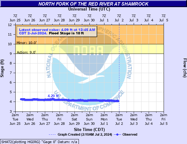 SHAT2 - North Fork of the Red River near Shamrock, OK (NWS Amarillo) |
 KTNT2 - Sweetwater Creek near Kelton, TX |
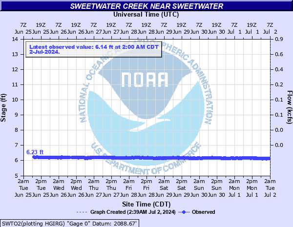 SWTO2 - Sweetwater Creek near Sweetwater, OK |
|
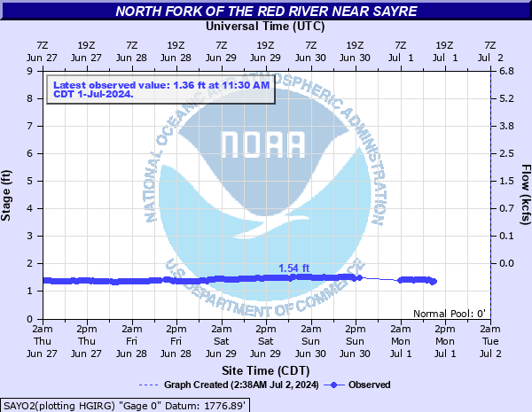 SAYO2 - North Fork of the Red River near Sayre, OK |
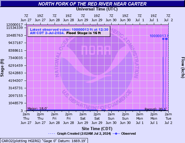 CARO2 - North Fork of the Red River near Carter, OK |
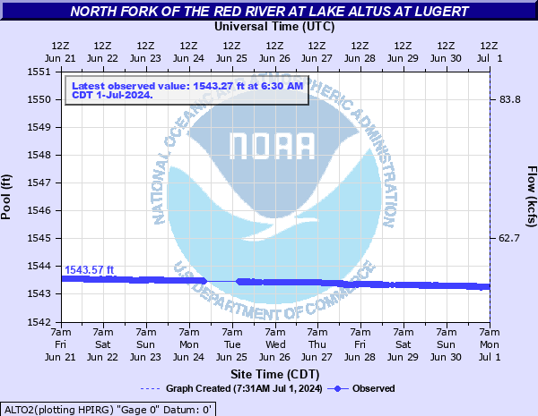 ALTO2 - North Fork of the Red River at Altus-Lugert Lake, OK |
|
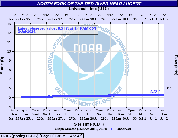 LGTO2 - North Fork of the Red River near Lugert, OK |
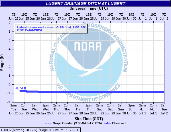 LDDO2 - Lugert Drainage Ditch at Lugert, OK |
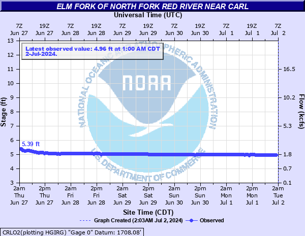 CRLO2 - Elm Fork of North Fork Red River near Carl, OK |
|
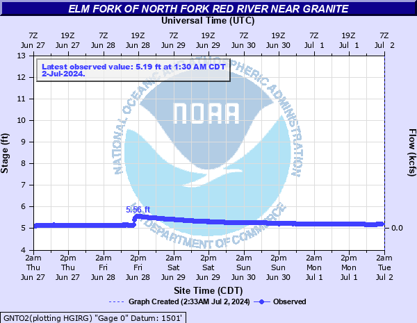 GNTO2 - Elm Fork of North Fork Red River near Granite, OK |
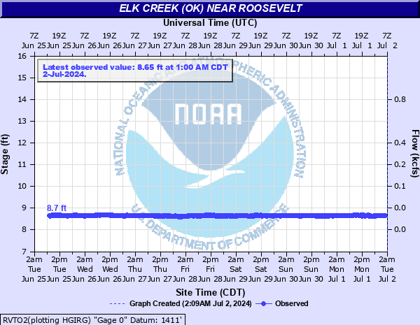 RVTO2 - Elk Creek near Roosevelt, OK |
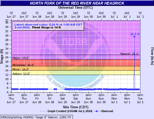 HEAO2 - North Fork of the Red River near Headrick, OK |
|
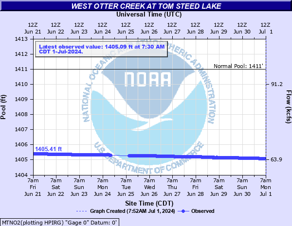 MTNO2 - West Otter Creek at Tom Steed Lake near Mountain Park OK |
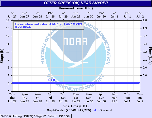 SYDO2 - Otter Creek near Snyder, OK |
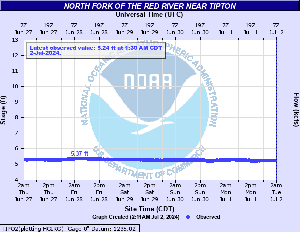 TIPO2 - North Fork of the Red River near Tipton, OK |
|
| WICHITA RIVER (AND TRIBUTARIES) | |||
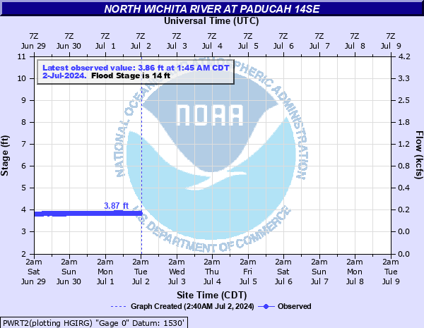 PWRT2 - North Wichita River near Paducah, TX (NWS Lubbock) |
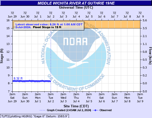 TLPT2 - Middle Wichita River near Guthrie, TX (NWS Lubbock) |
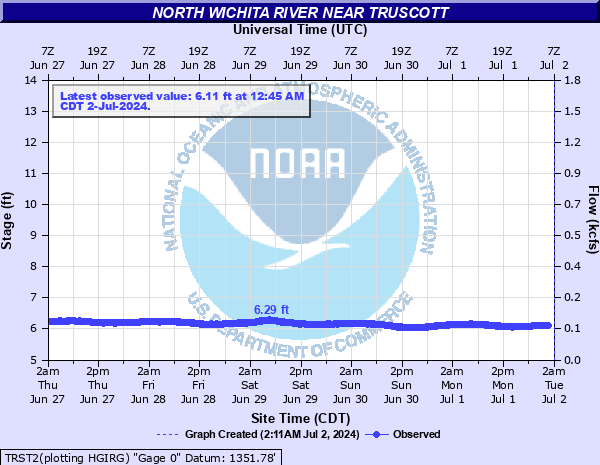 TRST2 - North Wichita River near Truscott, TX |
|
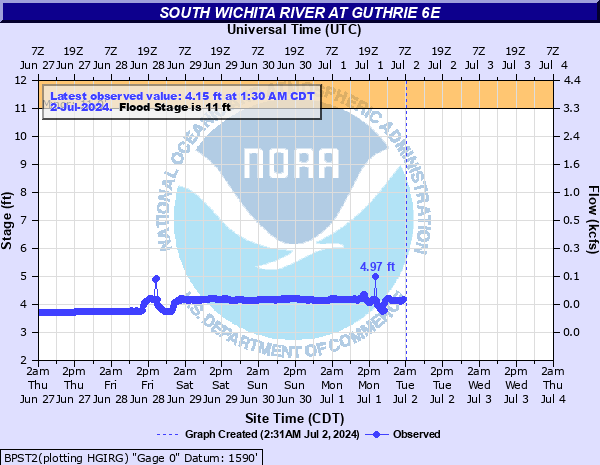 BPST2 - South Wichita River near Guthrie, TX (NWS Lubbock) |
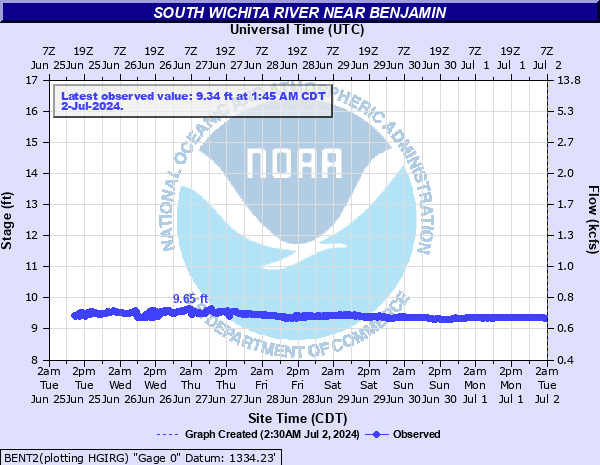 BENT2 - South Wichita River near Benjamin, TX |
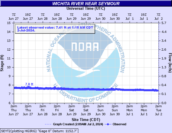 SEYT2 - Wichita River near Seymour, TX |
|
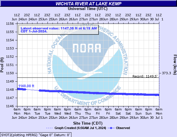 SYOT2 - Wichita River at Lake Kemp near Seymour, TX |
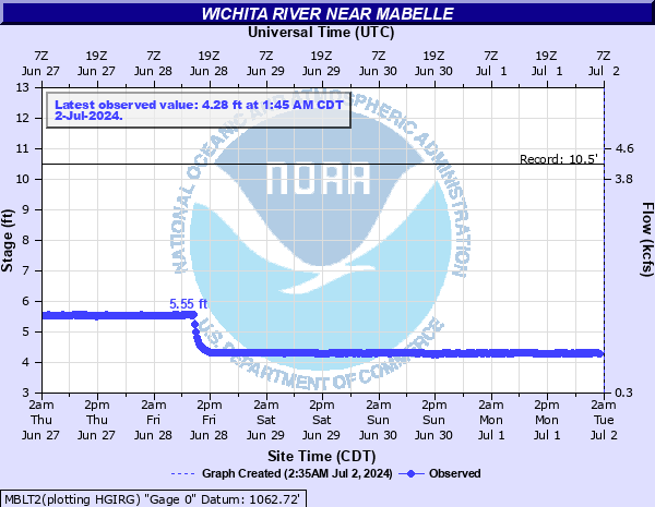 MBLT2 - Wichita River near Mabelle, TX |
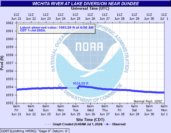 DDET2 - Wichita River at Lake Diversion near Dundee, TX |
|
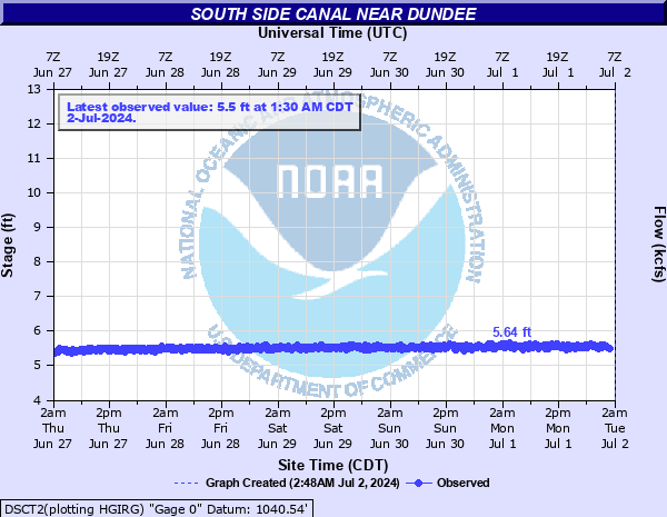 DSCT2 - Southside Canal near Dundee, TX |
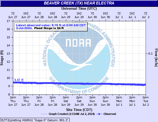 ELTT2 - Beaver Creek near Electra, TX |
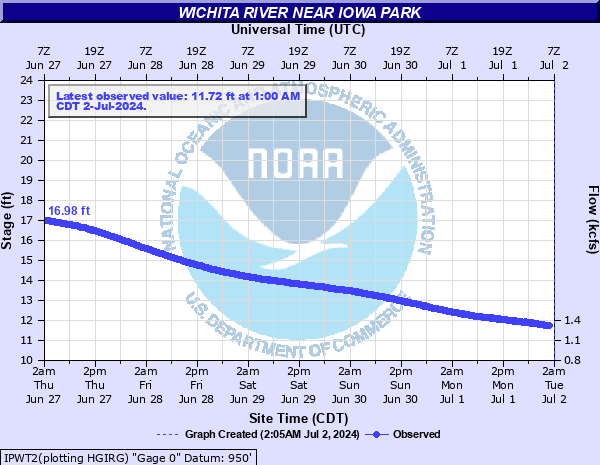 IPWT2 - Wichita River near Iowa Park, TX |
|
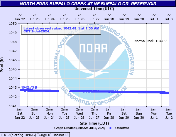 IPRT2 - North Fork Buffalo Creek Reservoir near Iowa Park, TX |
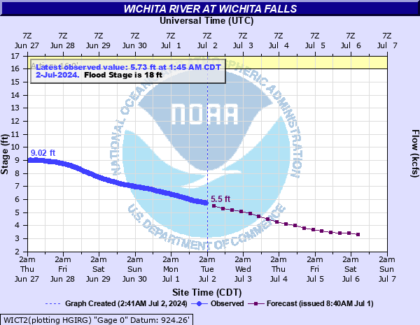 WICT2 - Wichita River at Wichita Falls, TX |
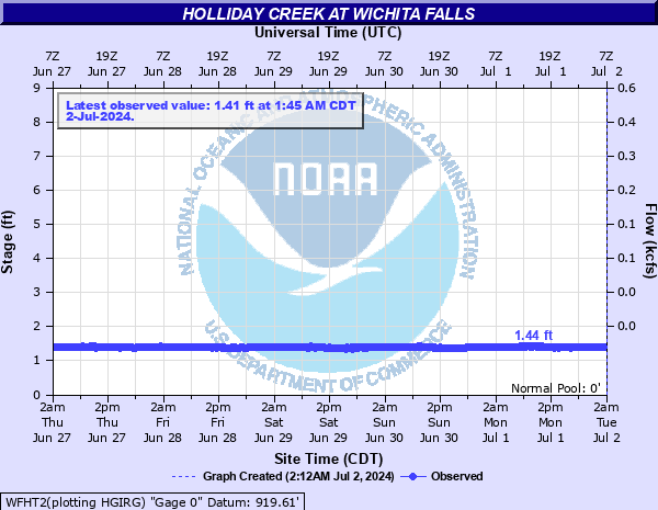 WFHT2 - Holliday Creek at Wichita Falls, TX |
|
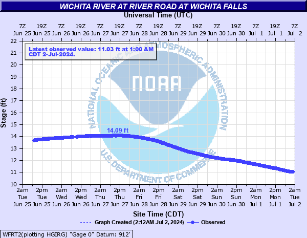 WFRT2 - Wichita River at River Road at Wichita Falls, TX |
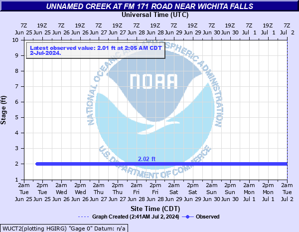 WUCT2 - Unnamed Creek at FM 171 Road near Wichita Falls, TX |
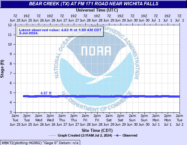 WBKT2 - Bear Creek at FM 171 Road near Wichita Falls, TX |
|
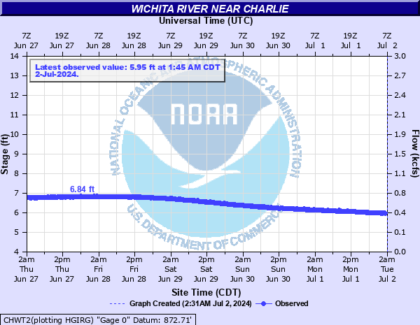 CHWT2 - Wichita River near Charlie, TX |
|||
| LITTLE WICHITA RIVER (AND TRIBUTARIES) | |||
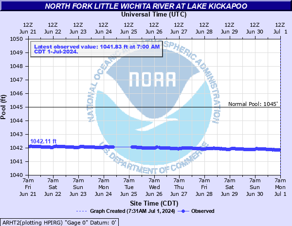 ARHT2 - Little Wichita River at Lake Kickapoo near Archer City, TX |
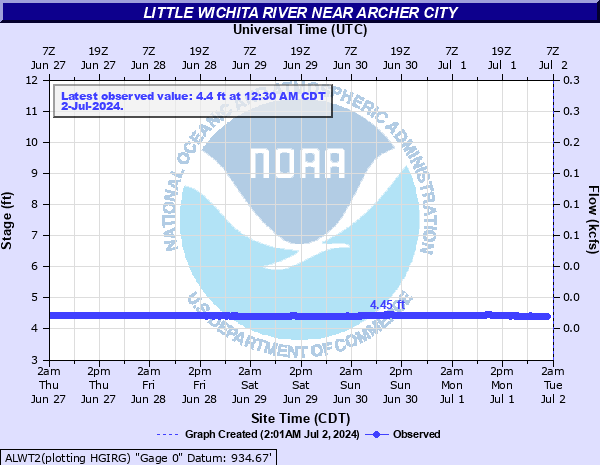 ALWT2 - Little Wichita River near Archer City, TX |
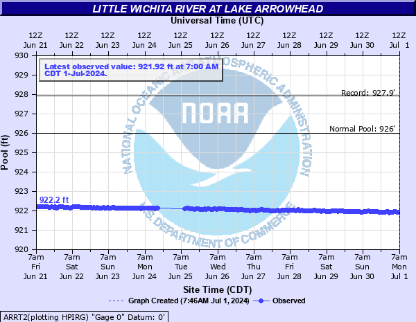 ARRT2 - Little Wichita River at Lake Arrowhead near Henrietta, TX |
|
 HTAT2 - Little Wichita River near Henrietta, TX |
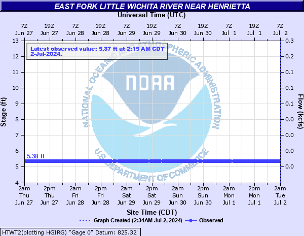 HTWT2 - East Fork Little Wichita River near Henrietta, TX |
||
| EAST CACHE CREEK, DEEP RED CREEK (AND TRIBUTARIES) | |||
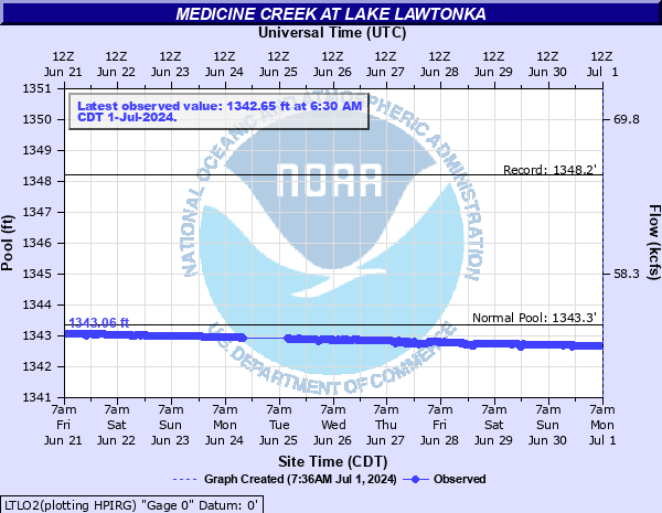 LTLO2 - Medicine Creek at Lake Lawtonka near Medicine Park, OK |
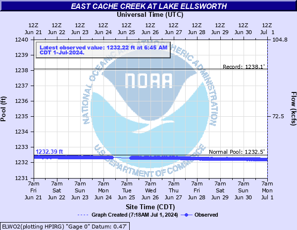 ELWO2 - East Cache Creek at Lake Ellsworth near Elgin, OK |
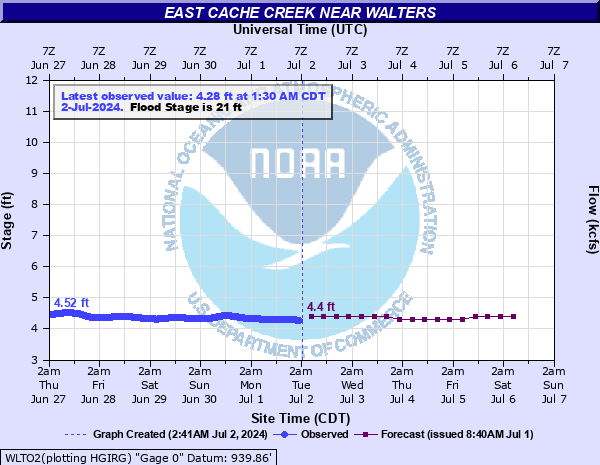 WLTO2 - East Cache Creek near Walters, OK |
|
 FDLO2 - Deep Red Creek at Lake Frederick near Frederick, OK |
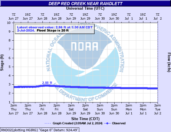 RNDO2 - Deep Red Creek near Randlett, OK |
||
| BEAVER CREEK (AND TRIBUTARIES) IN SC OK | |||
 HUBO2 - Beaver Creek near Hulen, OK |
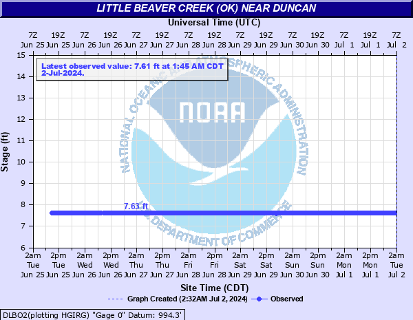 DLBO2 - Little Beaver Creek near Duncan, OK |
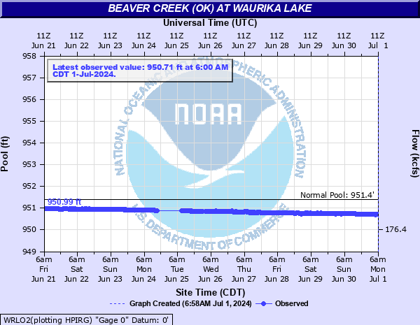 WRLO2 - Beaver Creek at Waurika Lake near Waurika, OK |
|
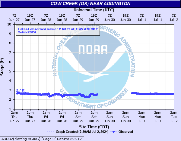 ADDO2 - Cow Creek near Addington, OK |
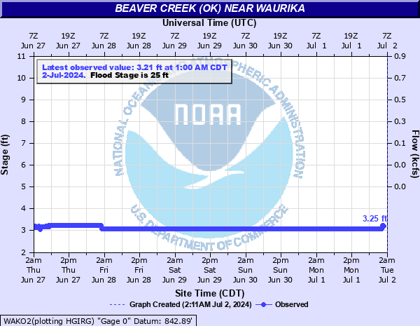 WAKO2 - Beaver Creek at Waurika, OK |
||
| WASHITA RIVER (AND TRIBUTARIES) | |||
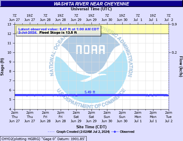 CHYO2 - Washita River near Cheyenne, OK |
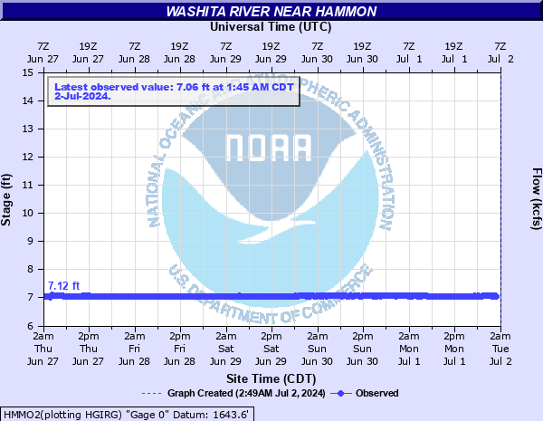 HMMO2 - Washita River near Hammon, OK |
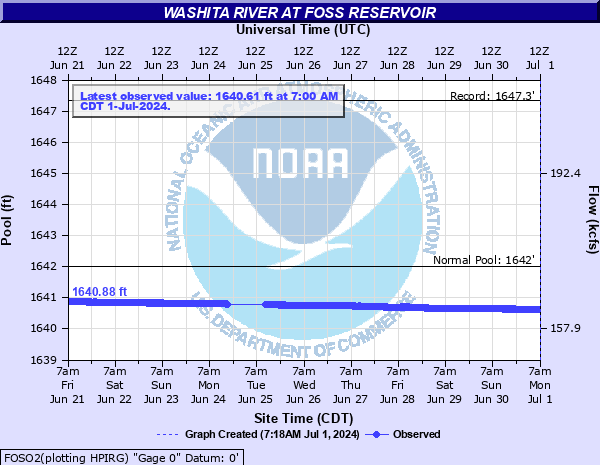 FOSO2 - Washita River at Foss Reservoir near Foss, OK |
|
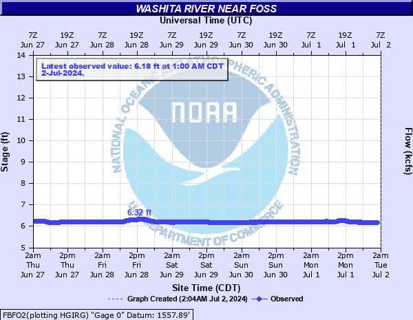 FBFO2 - Washita River near Foss, OK |
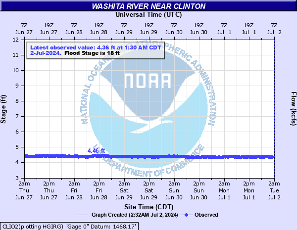 CLIO2- Washita River near Clinton, OK |
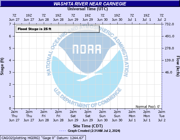 CAGO2 - Washita River near Carnegie, OK |
|
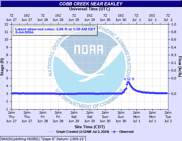 EAKO2 - Cobb Creek near Eakley, OK |
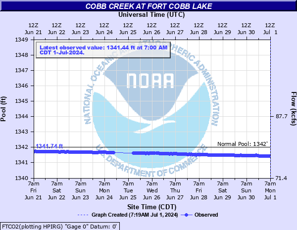 FTCO2 - Cobb Creek at Fort Cobb Lake near Fort Cobb, OK |
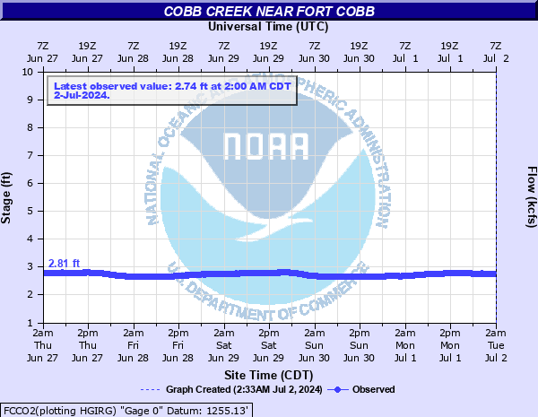 FCCO2 - Cobb Creek near Fort Cobb, OK |
|
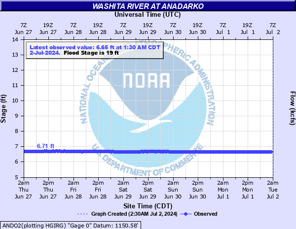 ANDO2 - Washita River at Anadarko, OK |
 CCKO2 - Washita River near Chickasha, OK |
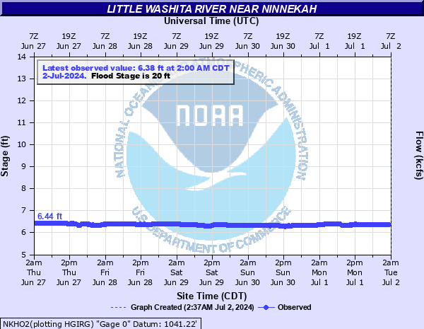 NKHO2 - Little Washita River near Ninnekah, OK |
|
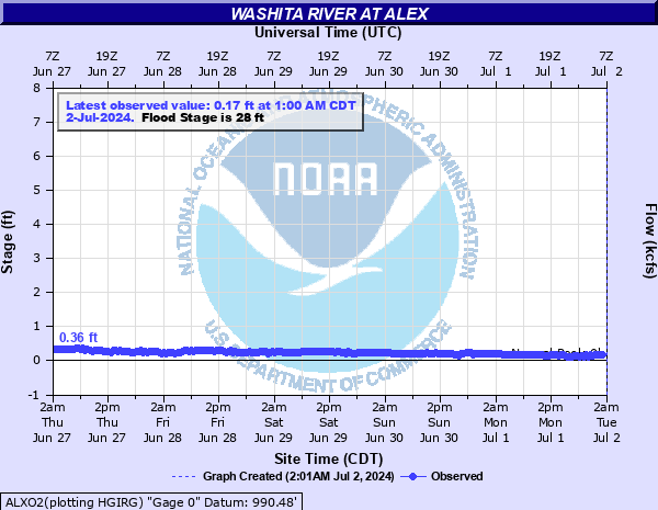 ALXO2 - Washita River at Alex, OK |
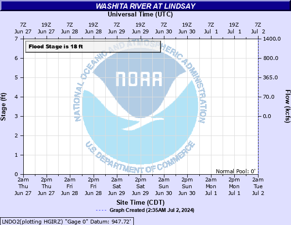 LNDO2 - Washita River near Lindsay, OK |
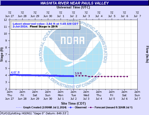 PLVO2 - Washita River near Pauls Valley, OK |
|
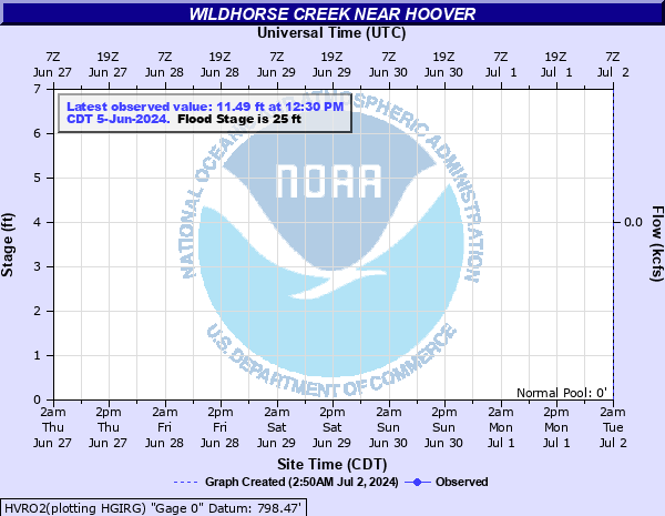 HVRO2 - Wildhorse Creek near Hoover, OK |
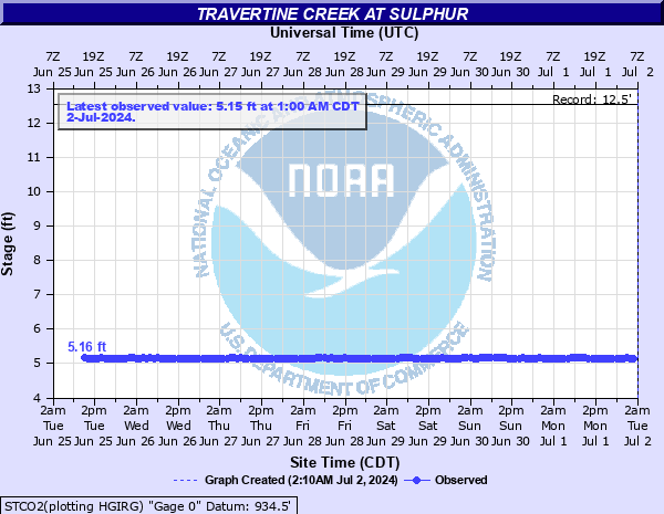 STCO2 - Travertine Creek at Sulphur, OK |
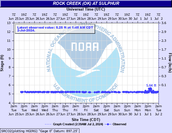 SRCO2 - Rock Creek at Sulphur, OK |
|
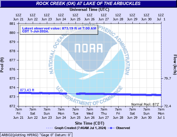 ARBO2 - Rock Creek at Lake of the Arbuckles near Dougherty, OK |
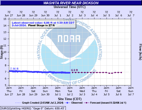 DURO2 - Washita River near Dickson, OK |
||
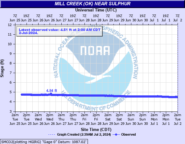 SMCO2 - Mill Creek near Sulphur, OK |
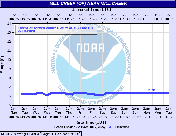 MCKO2 - Mill Creek near Mill Creek, OK |
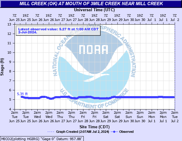 MICO2 - Mill Creek at Mouth of 3Mile Creek near Mill Creek, OK |
|
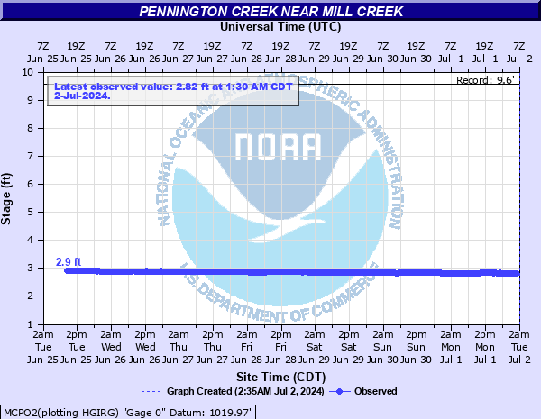
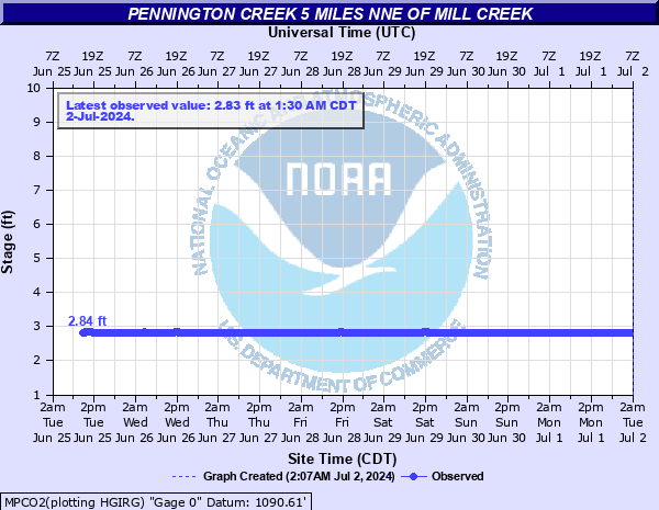 MPCO2 - Pennington Creek 5 Miles NNE of Mill Creek, OK |
 MCPO2 - Pennington Creek near Mill Creek, OK |
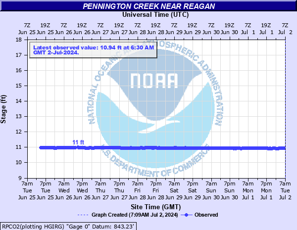 RPCO2 - Pennington Creek near Reagan, OK |
|
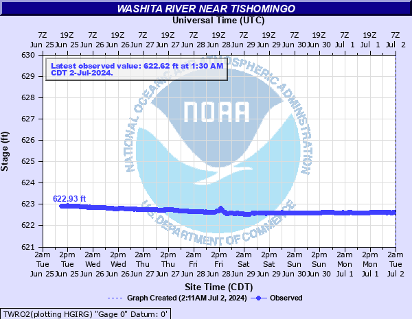 TWRO2 - Washita River near Tishomingo, OK |
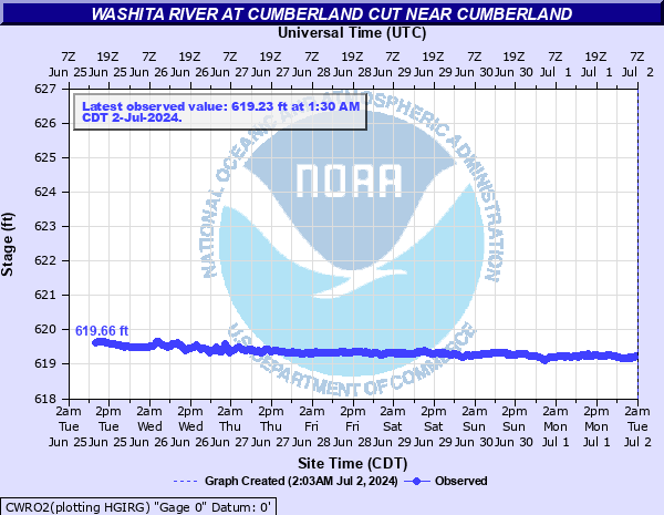 CWRO2 - Washita River at Cumberland Cut near Cumberland, OK |
||
| RED RIVER (AND SOME TRIBUTARIES) | |||
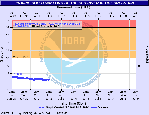 CHLT2 - Prairie Dog Town Fork of the Red River near Childress, OK (NWS Lubbock) |
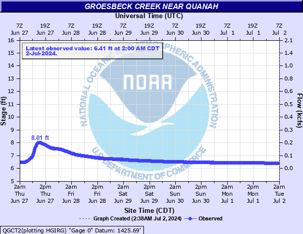 QGCT2 - Groesbeck Creek near Quanah, TX |
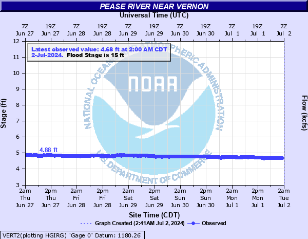 VERT2 - Pease River near Vernon, TX |
|
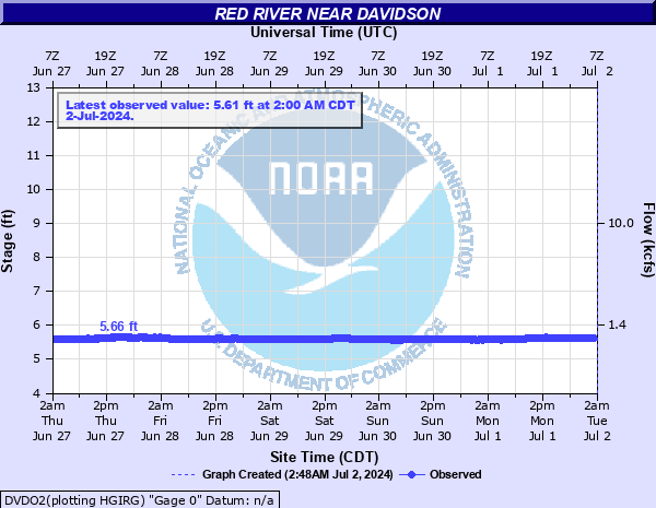 DVDO2 - Red River near Davidson, OK |
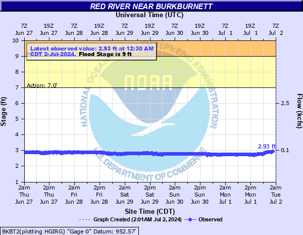 BKBT2 - Red River near Burkburnett, TX |
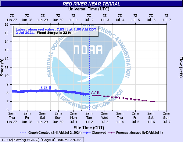 TRLO2 - Red River at Terral, OK |
|
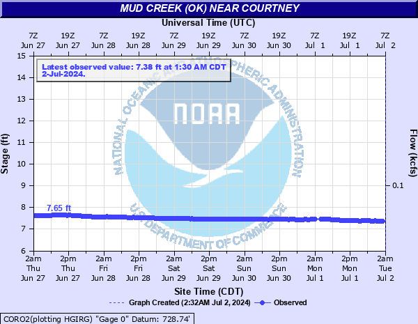 CORO2 - Mud Creek near Courtney, OK |
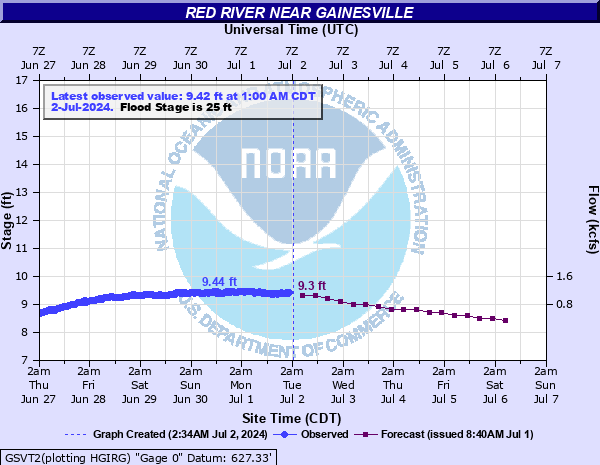 GSVT2 - Red River near Gainesville, TX |
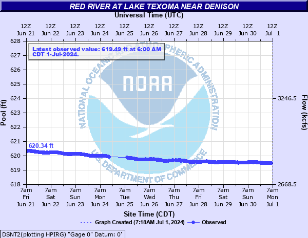 DSNT2 - Red River at Lake Texoma near Denison, TX |
|
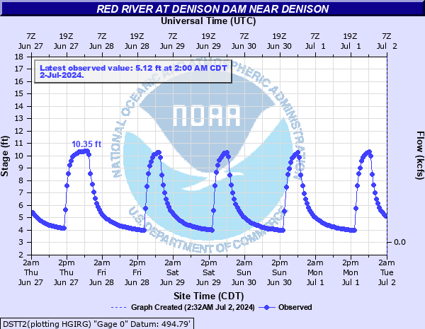 DSTT2 - Red River near Denison, TX |
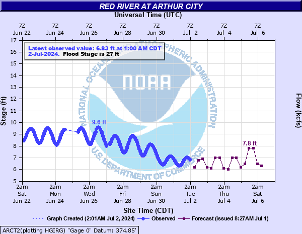 ARCT2 - Red River at Arthur City, TX (NWS Tulsa) |
||
| BLUE RIVER, CLEAR BOGGY CREEK AND MUDDY BOGGY CREEK | |||
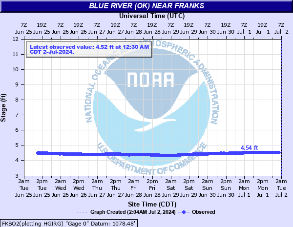 FKBO2 - Blue River near Franks, OK |
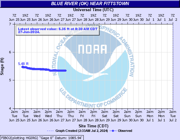 FIBO2 - Blue River near Fittstown, OK |
 CNBO2 - Blue River at Connerville, OK |
|
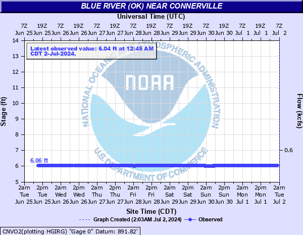 CNVO2 - Blue River near Connerville, OK |
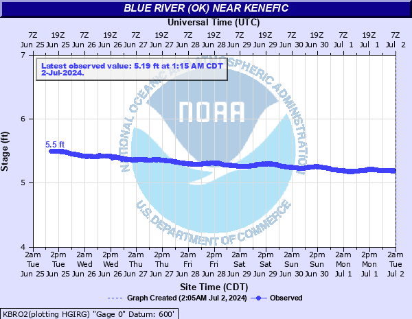 KBRO2 - Blue River near Kenefic, OK |
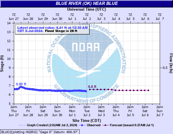 BLUO2 - Blue River near Blue, OK |
|
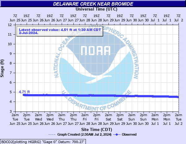 BDCO2 - Delaware Creek near Bromide, OK |
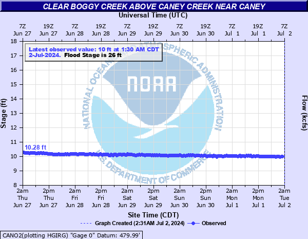 CANO2 - Clear Boggy Creek above Caney Creek near Caney, OK |
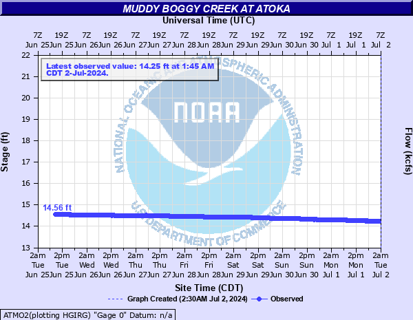 ATMO2 - Muddy Boggy Creek at Atoka, OK |
|
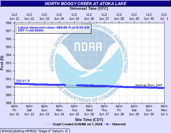 ATKO2 - North Boggy Creek at Atoka Lake near Atoka, OK |
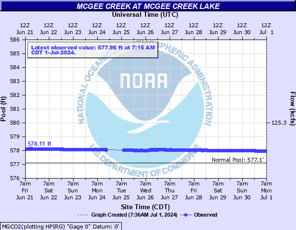 MGCO2 - McGee Creek at McGee Creek Lake near Farris, OK |
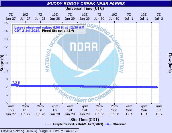 FRSO2 - Muddy Boggy Creek near Farris, OK |
|
| BRAZOS RIVER | |||
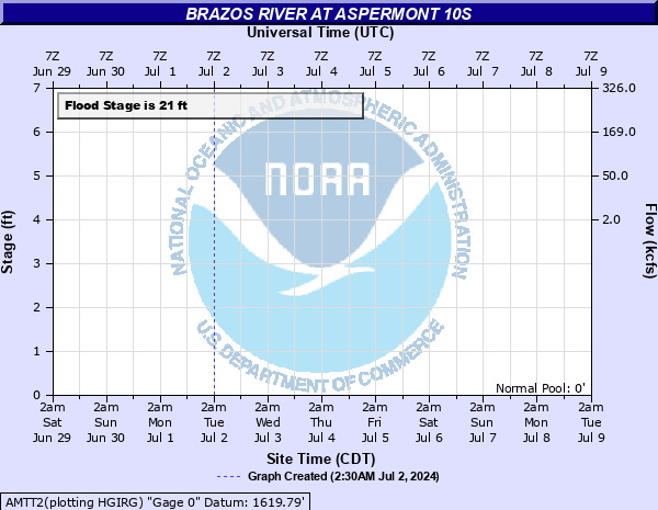 AMTT2 - Double Mountain Fork Brazos River near Aspermont, TX |
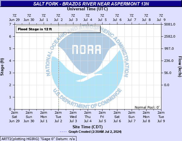 ARTT2 - Salt Fork Brazos River near Aspermont, TX |
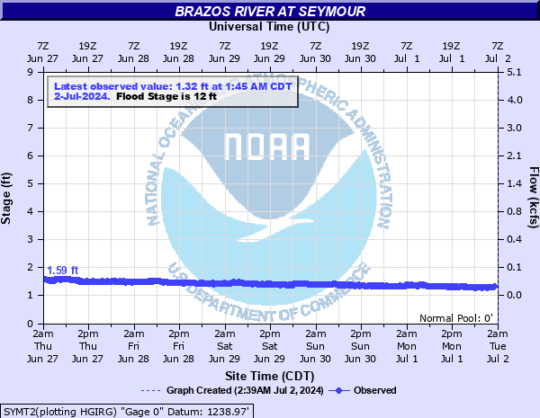 SYMT2 - Brazos River at Seymour, TX |
|

