*** 10 YEAR ANNIVERSARY ***
This is a before (left) and after (right) picture of the Smithville, Mississippi area. Notice the two water towers in the right image.
Read the Late April Tornado Outbreak Summary.
View all tornado tracks across the Midsouth for this outbreak.
Preliminary local storm reports for April 25th.
Preliminary local storm reports for April 26th.
Preliminary local storm reports for April 27th.
Interesting satellite and radar images from this event.
Storm account from an Itawamba county resident on April 27th, 2011
|
Click on a link below to see the latest storm survey information for the indicated Counties. (The table is arranged based on EF scale rating). |
||||||||||||||||||||||||||||||||||||||||||||||||||||||||||||||||||||||||||||||||||||||||||||||||||||||||||||||||||||||||||||||||||||||||||
|
||||||||||||||||||||||||||||||||||||||||||||||||||||||||||||||||||||||||||||||||||||||||||||||||||||||||||||||||||||||||||||||||||||||||||
|
|
The United States experienced a record-breaking tornado outbreak from the morning of April 25th through the early morning hours of April 28th. Survey teams from the NWS field offices across the region confirmed up to 305 tornadoes. For a quick comparison, the Super Outbreak of April 3-4, 1974 produced 148 tornadoes. Tragically, multiple killer tornadoes occurred during this outbreak. Approximately 24 tornadoes, possibly more, caused an estimated 326 fatalities during this tornado outbreak. From 8 A.M. April 27th through 8 A.M. On April 28th, tornadoes took the lives of 309 people alone. This is the deadliest tornado outbreak since the April 3-4, 1974 Super Outbreak.
The first tornado producing storms to move across the Mid-South developed in Southwestern Arkansas during the late afternoon hours of April 25th. These storms developed ahead of a cold front and surface low pressure. The storms formed into a bow echo, similar to the squall line that moved across the Mid-South on April 4, 2011. The bow echo raced across central and eastern Arkansas and crossed the Mississippi River at around 10 pm on the 25th. These storms produced wind damage throughout its path. The first tornadoes were produced by this bow echo in Henderson, Carroll, and Weakley counties at around 12 am. This bow echo continued its fast eastward movement and exited the Mid-South by 1 am on the 26th. Heavy rain lingered across the Mid-South through most of the early morning hours.
Conditions cleared up across the Mid-South during the late morning hours on the 26th. This allowed the atmosphere to recharge and become unstable again. Wind shear was also strong, so the threat for supercells was high. The first supercells developed across eastern and southern Arkansas at around 3 pm ahead of the same cold front that the previous night’s storms formed on. One storm moved across Crittenden and Shelby counties between 5 and 7 pm. These storms produced wind damage and large hail. This storm later produced tornadoes in Hardeman and Chester counties. Three additional supercells produced tornadoes, very large hail, and wind damage across Phillips, Coahoma, and Tunica counties during this same time frame.
Additional storms formed across southern Arkansas and northern Louisiana during the overnight hours and crossed the Mississippi River by midnight. These storms produced a few tornadoes across Tallahatchie, Tishomingo, and Chickasaw, and Monroe counties during the early morning hours on the 27th. Heavy rain again lingered through most of the early to mid morning hours.
By noon on April 27th, all the elements began to come together for an extreme severe weather outbreak. First, a new surface low pressure developed overnight across western Arkansas and was heading towards the Mid-South. Second, a cold front was moving across central Arkansas. Third, a dry line, or a dividing line between moist air and dry air, developed across eastern Arkansas ahead of the cold front. Supercell thunderstorms began to form along this dry line by noon. Additional supercell thunderstorms formed well ahead of the dry line in the warm, very moist, unstable, and highly sheared environment present across Mississippi and Alabama. The supercell thunderstorms marched across Northern Mississippi and clipped Hardin county, Tennessee, producing a preliminary total of 8 tornadoes. The worst storm moved over Calhoun, Chickasaw, Monroe, and Itawamba counties, producing two tornadoes that killed 22 people. One of these two tornadoes was the ef-5 tornado that struck Smithville, Ms. One other supercell thunderstorm developed along the cold front in northeastern Arkansas. This storm produced 4 tornadoes over Craighead county. The worst storms finally pushed out of the Mid-South by 5:30 pm on April 27th. In all, a total of 22 tornadoes were confirmed across the Mid-South over this 3 day outbreak.
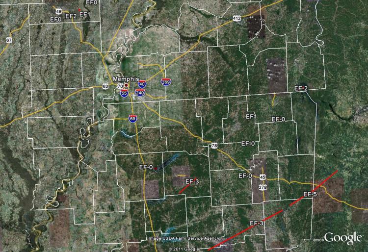
Here are all of the tornado tracks across the Midsouth for the entire late April 2011 Tornado Outbreak:
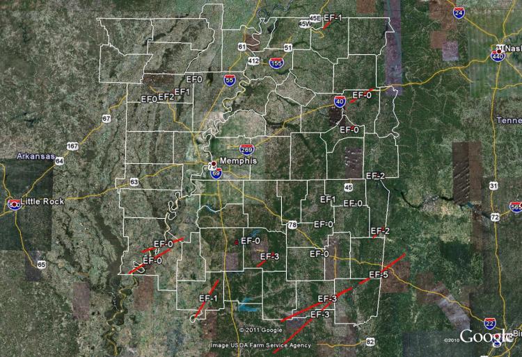
Here are all of the tornado tracks across the Midsouth for Monday night, April 25th:
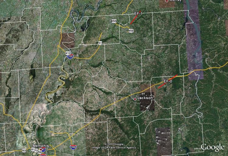
Here are all of the tornado tracks across the Midsouth for Tuesday evening, April 26th:
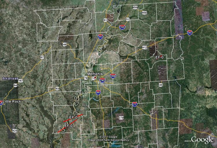
Here are all of the tornado tracks across the Midsouth for early Wednesday morning, April 27th:
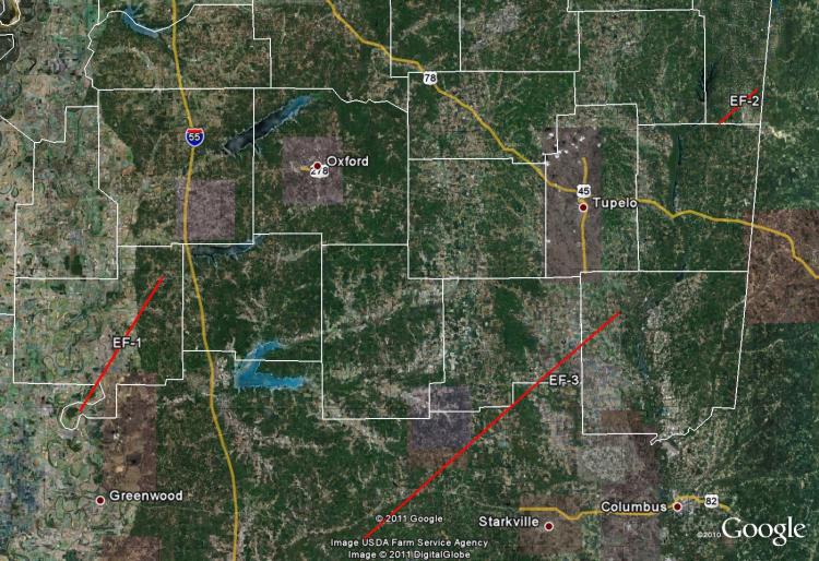
Here are all of the tornado tracks across the Midsouth for Wednesday afternoon, April 27th:
