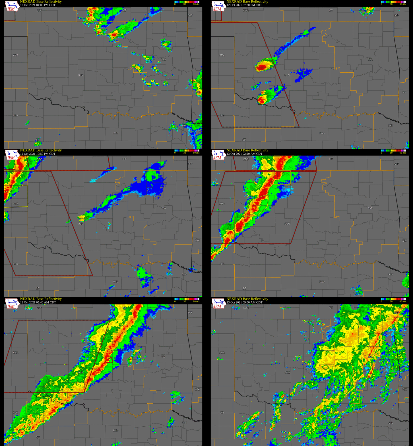
A warm front lifted north during the afternoon and evening of the October 12, 2021, with a couple supercell thunderstorms developing along it across southwest Oklahoma. Large hail, strong winds, and numerous tornadoes were reported with these storms as they moved northeastward. Later, a line of severe storms moved into far western Oklahoma along a cold front, with strong winds and hail reported with these storms.
Summaries of some of the tornadoes that occurred in the NWS Norman forecast area follow.
A storm chaser observed a brief tornado near State Highway 6 approximately 4 miles north-northwest of Retrop. No damage was reported. This was the first tornado to occur in the NWS Norman forecast area during this event.
A storm chaser photographed a tornado approximately 3 miles south of Foss. No damage was reported from the second tornado of the event and the location is estimated.
Several storm chasers, including an off-duty meteorologist from the Storm Prediction Center, observed a brief tornado approximately 5 miles southwest of Frederick. No damage was reported with the third tornado of the event and the location is estimated.
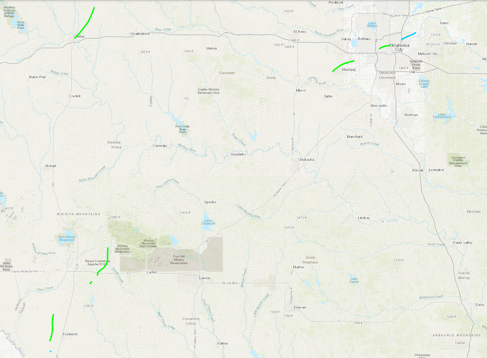
The fourth tornado developed 3.5 miles southwest of Fredrick and moved north or just east of due north for 7 miles. A barn had significant wall damage to the northwest of Frederick. Otherwise, there were a few pivot irrigators that were tipped over to the southwest and west of Frederick, and tree and power pole damage was also observed along the path.
The fifth tornado developed on the east side of Clinton near First Street and U.S. Route 66 (U.S. Business Highway I-40) where it damaged a automobile body shop and damaged a warehouse building. The tornado moved northeast across Riverside Golf Course where trees were damaged, then damaged and destroyed hangars at Clinton Municipal Airport (CLK). After the damage at the Clinton Municipal Airport, the tornado moved through more rural areas but did continue to damage trees, blow the roof off at least one outbuilding (with the debris blown to the northwest) and blew a street sign 200 yards. At one point, storm chasers observed a satellite tornado adjacent to this tornado (see separate entry).
A number of storm chasers from various angles observed another tornado (and sixth tornado of the event) adjacent to the fifth tornado that moved from the east side of Clinton to southeast of Custer City. Although motion was difficult to determine at night, was believed to be a satellite tornado. This tornado produced no known damage and the location of this tornado was estimated.
The seventh tornado was observed for two minutes northeast of Manitou, OK moving from Tillman County into Kiowa County. A barn roof and a few trees were damaged near the county line.
The eighth tornado developed about 6 miles east-southeast of Snyder to the south of U.S. Highway 62. It quickly became a large tornado as it moved sporadically north and northeast before crossing into Comanche County about 3 miles north of U.S. Highway 62. In Kiowa County, the tornado produced tree and power pole damage. After the tornado moved into Comanche County from Kiowa County approximately three miles north of U.S. Highway 62, it moved northeast and then due north. At least one home suffered some shingle damage, a mobile home received roof damage, and a barn door was blown in. Tree damage was also observed along the path. None of the damage in Comanche County was observed to be greater than EF0, although the tornado was likely stronger as there were few damage indicators encountered along the path.
WSR-88D radar indicated strong rotation with a tornado debris signature in an inaccessible area of the Wichita Mountains near the wildlife refige headquarters area and west of Meers, OK. The path and path dimensions are estimated for the ninth tornado of the event.
A storm chaser photographed the tenth tornado looking northwest from 1 mile west of Boone. No damage was reported in the area and the specific location of the tornado is estimated.
The eleventh tornado was produced from a QLCS (quasi-linear convective system) and touched down on the west edge of Mustang, just south of State Highway 152 near Frisco Road. The tornado moved generally northeast affecting portions of Mustang and southwest Oklahoma City. The most significant structure damage was southeast of SW 44th Street and Czech Hall Road where a home received roof damage, and a pickup truck parked on the street was rolled over. A few other homes along the path also received damage to shingles, otherwise damage was generally confined to trees, including some tree trunks snapped. The tornado dissipated southwest of SW 29th Street and County Line Road in southwest Oklahoma City.
The twelfth tornado of the event and second tornado generated by the QLCS (quasi-linear convective system) touched down just east of the Oklahoma State Fairgrounds and near General Pershing Boulevard just east of May Avenue. The tornado moved northeast and east affecting the Youngs-Englewood, Classen-Ten-Penn, Plaza, Mesta Park and Heritage Hills districts of Oklahoma City. Damage was generally confined to tree damage, including some snapped tree trunks. There was no significant structure damage observed. The tornado dissipated just southeast of NE 23rd Street and U.S. Interstate Highway I-235.
The thirthteenth and last tornado of the event was also the third tornado produced from a QLCS (quasi-linear convective system) storm system that affected the Oklahoma City area. The tornado developed over Forest Park near NE 36th Street and Bryant Avenue, and moved northeast into northeast Oklahoma City dissipating northwest of NE 63rd Street and Midwest Boulevard. The damage observed was generally broken tree branches and limbs.
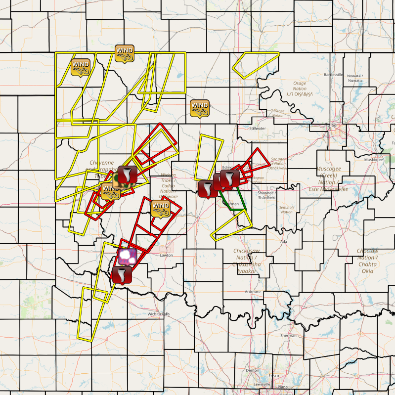
| Tornadoes by Intensity | |||||||
|---|---|---|---|---|---|---|---|
| EFU | EF0 | EF1 | EF2 | EF3 | EF4 | EF5 | Total |
| 4 | 3 | 6 | 0 | 0 | 0 | 0 | 13 |
| Tornado Number |
Date | Time (CST) |
Length of Path (miles) |
Width of Path (yards) |
F-Scale | Killed | Injured | County | Location |
|---|---|---|---|---|---|---|---|---|---|
| 1 | 10/12/2021 | 1748 | 0.1 | 10 | EF0 | 0 | 0 | Beckham | 4 NNW Retrop |
| 2 | 10/12/2021 | 1824 | 0.1 | 25 | EF? | 0 | 0 | Washita | 3 S Foss |
| 3 | 10/12/2021 | 1838 | 0.4 | 30 | EF0 | 0 | 0 | Tillman | 5 SW Frederick |
| 4 | 10/12/2021 | 1841-1858 | 7 | 300 | EF1 | 0 | 0 | Tillman | 3.5 WSW Frederick - 5 E Tipton |
| 5 | 10/12/2021 | 1855-1925 | 10 | 400 | EF1 | 0 | 0 | Custer | Clinton (east) - Clinton airport (KCLK) - 2 SSE Custer City |
| 6 | 10/12/2021 | 1901 | 0.2 | 20 | EF? | 0 | 0 | Custer | 2 NE Clinton |
| 7 | 10/12/2021 | 1919-1921 | 0.9 | 300 | EF1 | 0 | 0 | Tillman/ Kiowa | 7 NE Manitou - 5 SE Snyder |
| 8 | 10/12/2021 | 1926-1944 | 8 | 900 | EF1 | 0 | 0 | Kiowa/ Comanche | 6 ESE Snyder - 9 NNW Indiahoma |
| 9 | 10/12/2021 | 2000-2007 | 2.6 | 50 | EF? | 0 | 0 | Comanche | 6 W - 5 WNW Meers |
| 10 | 10/12/2021 | 2035-2036 | 0.5 | 30 | EF? | 0 | 0 | Caddo | 5 NW Boone |
| 11 | 10/13/2021 | 0359-0408 | 6 | 150 | EF1 | 0 | 0 | Canadian | west Mustang (SE of SH-152 and Frisco Road) - southwest Oklahoma City (SW of SW 29th St and County Line Road) |
| 12 | 10/13/2021 | 0415-0419 | 3 | 75 | EF1 | 0 | 0 | Oklahoma | Oklahoma City (SE of NW 10th Street and May Avenue - SE of NE 23rd Street and Interstate 235) |
| 13 | 10/13/2021 | 0422-0428 | 4 | 50 | EF0 | 0 | 0 | Oklahoma | Forest Park (near NE 36th Street and Bryant Ave) - northeast Oklahoma City (NW of NE 63rd Street and Midwest Boulevard) |
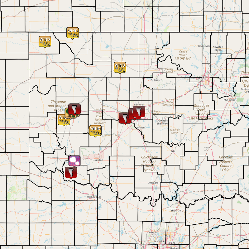
| Report Date |
Report Time (CST) |
Location | County | State | Event Type |
Mag. | Source | Lat. | Lon. | Remark |
|---|---|---|---|---|---|---|---|---|---|---|
| 10/12/2021 | 19:25 | 1 WNW Burns Flat | Washita | OK | Tstm Wnd Gust | 77 mph | ASOS | 35.36 | -99.20 | |
| 10/12/2021 | 19:39 | 2 SSW Frederick | Tillman | OK | Tornado | Public | 34.36 | -99.03 | ||
| 10/12/2021 | 19:50 | Clinton | Custer | OK | Tstm Wnd Damage | Emergency Mgr, | 35.51 | -98.97 | Roof removed from structure on east side of Clinton. Several structures damaged at the airport. Time estimated by radar. | |
| 10/12/2021 | 19:53 | 4 WSW Clinton | Custer | OK | Tstm Wnd Damage | Trained Spotter | 35.48 | -99.04 | Semi-truck overturned on U.S. Interstate Highway I-40 near exit 62. | |
| 10/12/2021 | 20:01 | 1 SSE Arapaho | Custer | OK | Tornado | Broadcast Media | 35.56 | -98.95 | Time and location estimated by radar. | |
| 10/12/2021 | 20:21 | 5 S Snyder | Tillman | OK | Hail | 1.75 in. | Public | 34.58 | -98.95 | |
| 10/12/2021 | 21:40 | 4 NNW Fort Cobb | Caddo | OK | Tstm Wnd Gust | 58 mph | Mesonet | 35.15 | -98.47 | |
| 10/13/2021 | 00:05 | 1 SW Buffalo | Harper | OK | Tstm Wnd Gust | 60 mph | Mesonet | 36.82 | -99.64 | |
| 10/13/2021 | 01:15 | 16 NNE Freedom | Woods | OK | Tstm Wnd Gust | 63 mph | Mesonet | 36.98 | -99.00 | |
| 10/13/2021 | 01:20 | 16 NNE Freedom | Woods | OK | Tstm Wnd Gust | 79 mph | Mesonet | 36.98 | -99.00 | |
| 10/13/2021 | 01:25 | 16 NNE Freedom | Woods | OK | Tstm Wnd Gust | 71 mph | Mesonet | 36.98 | -99.00 | |
| 10/13/2021 | 03:50 | Vance Air Force Base | Garfield | OK | Tstm Wnd Gust | 63 mph | Other Federal | 36.34 | -97.90 | |
| 10/13/2021 | 04:59 | 3 W Mustang | Canadian | OK | Tornado | NWS Storm Survey | 35.39 | -97.78 | An EF1 tornado moved through Mustang and southwest Oklahoma City from south of OK State Highwa 152 and Frisco Road to southwest of SW 29th Street and County Line Road. | |
| 10/13/2021 | 05:15 | 3 W Oklahoma City | Oklahoma | OK | Tornado | NWS Storm Survey | 35.47 | -97.56 | An EF1 tornado moved from southwest of NW 10th Street and Villa Avenue to near U.S. Interstate Highway I-235 and NE 21st Street. | |
| 10/13/2021 | 05:23 | 4 NE Oklahoma City | Oklahoma | OK | Tornado | NWS Storm Survey | 35.51 | -97.46 | An EF0 tornado produced sporadic tree damage in Forest Park and northeast Oklahoma City from near NE 36th Street and Bryant Avenue to west of NE 10th Street and Midwest Boulevard. |
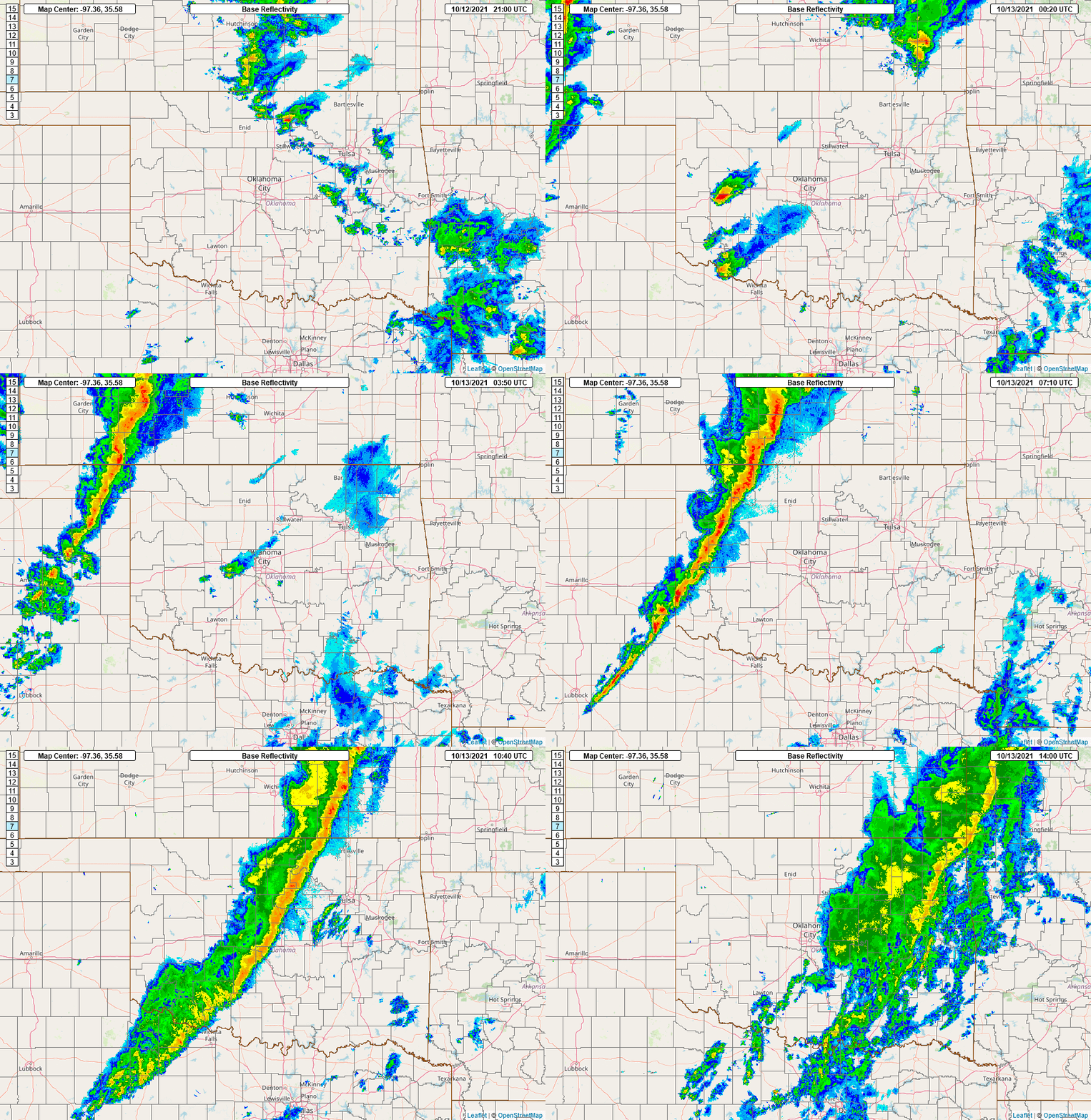
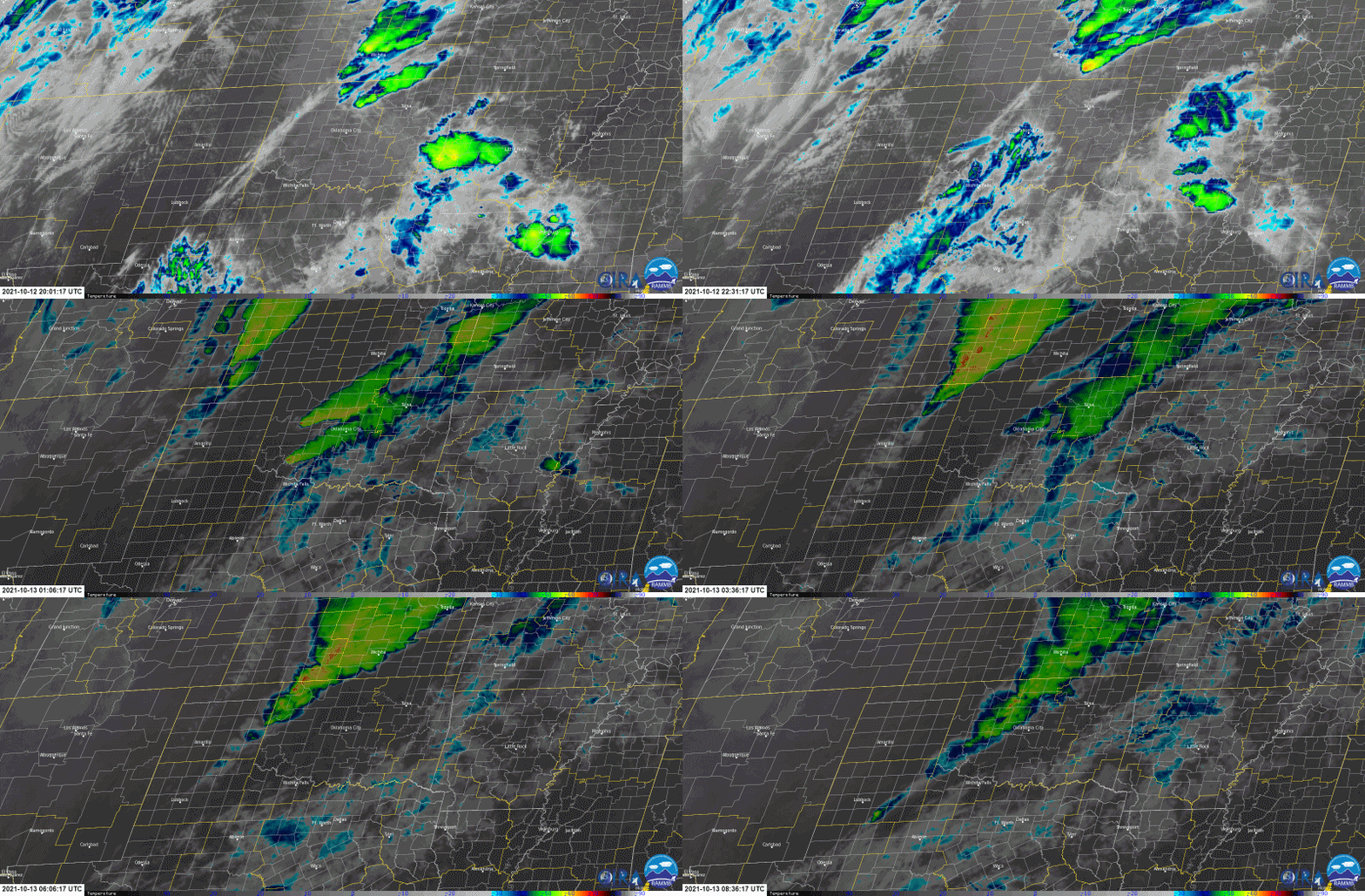
Satellite Loop from 3:01 pm CDT on October 10, 2021 to 3:36 am CDT on October 13, 2021
Credit: Cooperative Institute for Research in the Atmosphere at Colorado State University
and the National Oceanic and Atmospheric Administration (CSU/CIRA & NOAA)