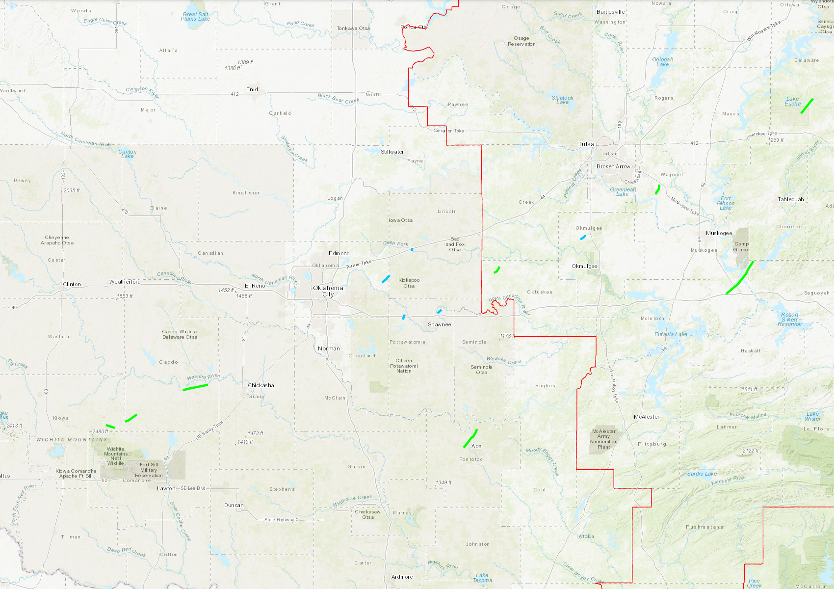
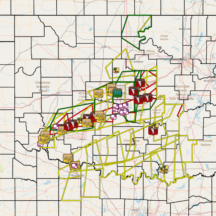
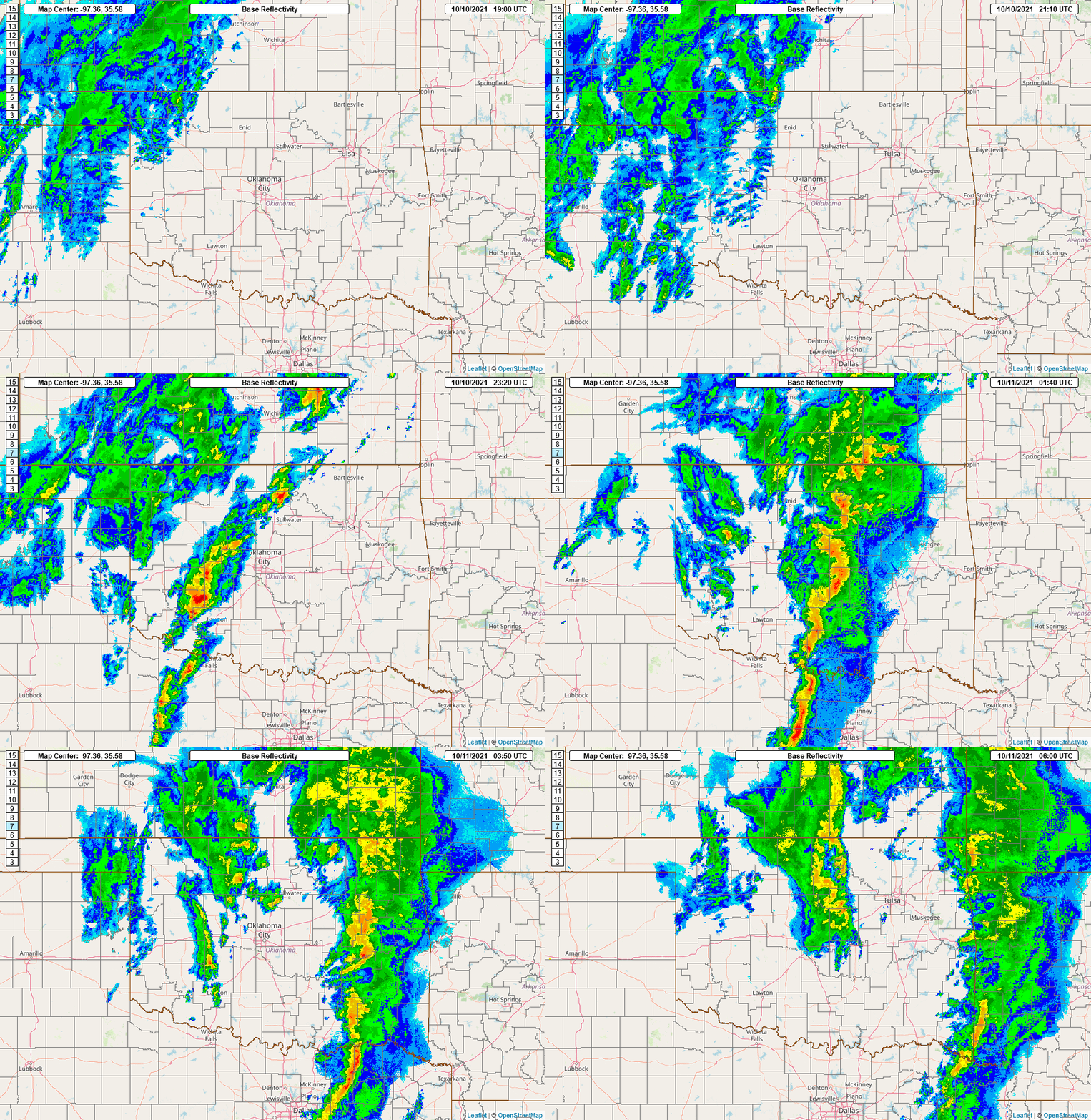
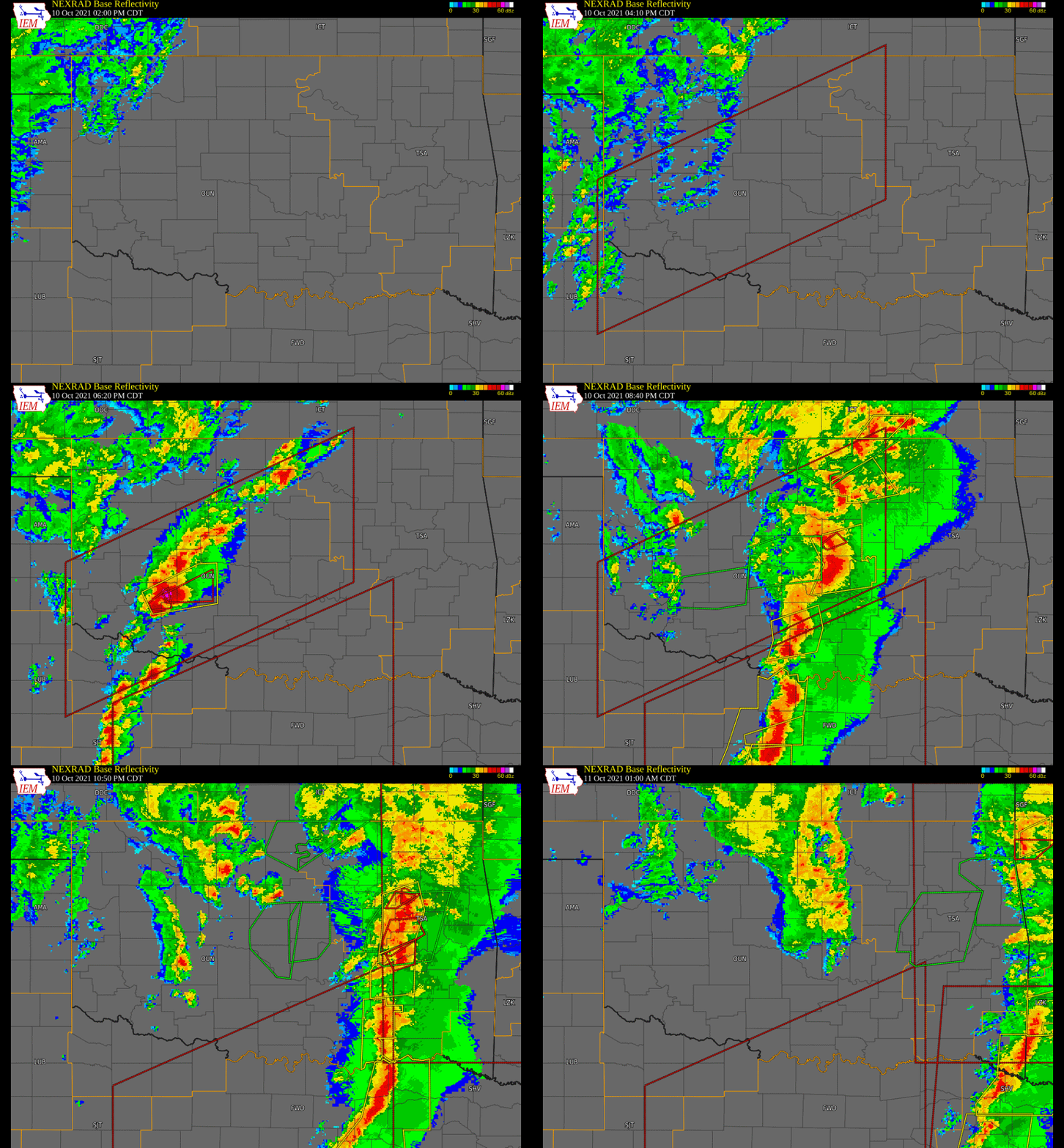
An unseasonably warm and moist airmass was in place across the region ahead of a powerful upper wave moving out of the 4 corners region of the western U.S. This led to the development of numerous severe thunderstorms across Oklahoma and Texas during the afternoon and evening of October 10, 2021. Multiple tornadoes were reported, along with hail larger than baseballs that impacted Norman, OK for the second time in six months, leading to millions of dollars in damages once again to homes, cars, and businesses. In Oklahoma, 11 tornadoes occurred in the NWS Norman forecast area while 7 more tornadoes occurred in the NWS Tulsa forecast area.
Summaries of some of the tornadoes occurring in the NWS Norman forecast area follow.
A number of storm chasers observed a brief tornado approximately 4 miles south-southwest of Cooperton in Kiowa County. No damage was reported and the location was estimated for the first tornado in the NWS Norman forecast area.
The second tornado was initially observed by storm chasers including an off-duty meteorologist from the Storm Prediction Center and was visible for a couple of minutes before becoming wrapped in rain. The rain-wrapped tornado likely continued generally east-southeast and destroyed a trailer and damaged trees at the Saddle Mountain cemetery.
Numerous storm chasers observed the third tornado that developed about 9 miles west of Boone near the Kiowa-Caddo County line. The tornado moved northeast crossing State Highways 58 and 19 causing significant roof damage to a home and breaking power poles. Although this tornado became wrapped in rain and was generally not visible after crossing the highway, additional tree damage was reported east of the highway, and it is believed to have continued northeast approximately three miles
Storm chasers initially observed the fourth tornado develop southwest of Anadarko and move east-northeast. Damage was reported to a hangar at the Anadarko airport just south of town. The most significant damage was about 5 miles east of Anadarko where a roof was removed from a home. Although the tornado itself passed just south of Anadarko, the storm produced widespread wind damage within the town of Anadarko.
While the fourth tornado was occurring just south of Anadarko, thunderstorm winds were also causing damage in Anadarko . The most concentrated area of damage was in the vicinity of Oklahoma Avenue, Broadway Avenue and Main Street near the railroad tracks, or just northeast of the intersection of U.S. Highway 281 and OK State Highway 8. A few buildings were damaged including the loss of the brick facade of one building. Trees, power poles and fences were also damaged in the area.
Storm chasers observed the fifth tornado which initially developed in Caddo County approximately 3 miles southwest of Verden and moved east-northeast crossing into Grady County about 1.5 mile south of Verden and to a point approximately 1 mile south-southeast of Verden. The tornado path was estimated as no damage was reported along the tornado path. Despite no known damage from the tornado, the storm did produce wind damage in and north of the town of Verden. Strong thunderstorm winds produced damage in Verden including tree damage and the collapse of walls of an abandoned building on the north side of Verden.
A storm chaser observed the sixth tornado estimated to be approximately 3 miles north of Chickasha. No damage was reported in the immediate area of the tornado, although the storm was producing wind damage about three miles farther north.
The seventh tornado developed just southwest of NE 63rd Street and Dobbs Road to the north-northwest of Harrah. One mobile home sustained roof damage, otherwise the observed damage was generally confined to trees. The tornado crossed into Lincoln County at Britton Road (E 1000 Road). It continued to move northeast a short distance and produced tree damage.
The eighth tornado, which was produced by a QLCS (quasi-linear convective system) touched down just southwest of Warwick and moved north through the west edge of Warwick. A barn was destroyed along U.S. Route 66 near the beginning of the path, and trees were damaged along the path, including at Hurst Park in Warwick. The tornado was reported to have crossed the Turner Turnpike before dissipating.
The tornado developed approximately 1.5 miles south-southwest of Dale as indicated by a Tornado Debris Signature (TDS) in this location, although this area was not accessible to the storm damage survey team. The tornado moved north-northeast damaging trees and a service station canopy just north of U.S. Interstate Highway I-40. A barn west of Dale was also damaged.
The tenth tornado initially developed about 2 miles west-southwest of Johnson, likely in the North Canadian River valley as evidenced by the development of a Tornado Debris Signature (TDS) on radar. The tornado moved northeast producing mainly tree damage, including a tree damaging the roof of a house along Garretts Lake Road. Much of the path of this tornado was estimated being in inaccessible areas.
The eleventh tornado to occur in the NWS Norman forecast area developed west of Ada southwest of County Roads 1540 and 3530. The tornado produced damage to barns along County Road 3350 and then EF1 damage to metal buildings at a tractor dealer just before crossing OK State Highway 19. It continued to produce tree damage in areas northwest and north of Ada. A few homes received roof or garage door or patio damage east of U.S. Highway 377 between Ada and Byng, and in the southeast portion of Byng. The tornado dissipated just east of the city limits of Byng.


| Tornadoes by Intensity | |||||||
|---|---|---|---|---|---|---|---|
| EFU | EF0 | EF1 | EF2 | EF3 | EF4 | EF5 | Total |
| 5 | 5 | 7 | 1 | 0 | 0 | 0 | 18 |
| Tornado Number |
Date | Time (CST) |
Length of Path (miles) |
Width of Path (yards) |
F-Scale | Killed | Injured | County | Location |
|---|---|---|---|---|---|---|---|---|---|
| 1 | 10/10/2021 | 1659 | 0.1 | 20 | EF? | 0 | 0 | Kiowa | 4 SSW Cooperton |
| 2 | 10/10/2021 | 1713-1718 | 3 | 200 | EF1 | 0 | 0 | Kiowa | 8 E - 11 E Cooperton (Saddle Mountain area) |
| 3 | 10/10/2021 | 1720-1725 | 4 | 50 | EF1 | 0 | 0 | Caddo | 9 W - 6 WNW Boone |
| 4 | 10/10/2021 | 1745-1759 | 8 | 100 | EF2 | 0 | 0 | Caddo | 4 SW - 5 E Anadarko |
| 5 | 10/10/2021 | 1802-1805 | 1.8 | 50 | EF? | 0 | 0 | Caddo/ Grady | 3 SW - 1 SSE Verden |
| 6 | 10/10/2021 | 1816 | 0.2 | 50 | EF? | 0 | 0 | Grady | 3 N Chickasha |
| 7 | 10/10/2021 | 1921-1926 | 3 | 250 | EF0 | 0 | 0 | Oklahoma/ Lincoln | 3 NNW - 5.5 NNE Harrah |
| 8 | 10/10/2021 | 1941-1942 | 1.1 | 30 | EF0 | 0 | 0 | Lincoln | 1 SW - 0.5 N Warwick |
| 9 | 10/10/2021 | 1941-1943 | 1.6 | 50 | EF0 | 0 | 0 | Pottawatomie | 1.5 SSW - 0.5 W Dale |
| 10 | 10/10/2021 | 1954-1958 | 1.6 | 50 | EF0 | 0 | 0 | Pottawatomie | 2 WSW - 0.5 NW Johnson |
| 11 | 10/10/2021 | 2026-2032 | 2.7 | 300 | EF1 | 0 | 0 | Okfuskee | 5 N Paden - 7 WSW Welty |
| 12 | 10/10/2021 | 2026-2036 | 7 | 300 | EF1 | 0 | 0 | Pontotoc | 2.5 W Ada - 1 ENE Byng |
| 13 | 10/10/2021 | 2042-2043 | 1 | 100 | EF? | 0 | 0 | Creek | 10 S Bristow |
| 14 | 10/10/2021 | 2105-2112 | 2.2 | 300 | EF0 | 0 | 0 | Okmulgee | .7 SSE - 1.9 ENE Beggs |
| 15 | 10/10/2021 | 2130-2132 | 0.7 | 100 | EF? | 0 | 0 | Tulsa | 6 SSE - 5.7 SSE Bixby |
| 16 | 10/10/2021 | 2145-2152 | 3.4 | 700 | EF1 | 0 | 0 | Wagoner | 1.1 SSE - 2.4 NE Coweta |
| 17 | 10/10/2021 | 2230-2247 | 13.7 | 900 | EF1 | 0 | 0 | Muskogee/Sequoyah | 3.3 ESE Warner - 1.5 NW Paradise Hill |
| 18 | 10/10/2021 | 2310-2318 | 5.9 | 200 | EF1 | 0 | 0 | Delaware | 6.8 SE - 6.7 ESE Eucha |

| Report Date |
Report Time (CST) |
Location | County | State | Event Type |
Mag. | Source | Lat. | Lon. | Remark |
|---|---|---|---|---|---|---|---|---|---|---|
| 10/10/2021 | 17:16 | 3 NW Elmer | Jackson | OK | Hail | 1.25 in. | Public | 34.51 | -99.39 | Report through Twitter |
| 10/10/2021 | 17:27 | Altus Air Force Base | Jackson | OK | Hail | 1.00 in. | Trained Spotter | 34.66 | -99.29 | |
| 10/10/2021 | 17:45 | 3 S Altus | Jackson | OK | Tstm Wind Gust | 79 mph | Mesonet | 34.59 | -99.33 | |
| 10/10/2021 | 17:59 | 2 NE Altus Air Force Base | Jackson | OK | Tstm Wind Gust | 66 mph | AWOS | 34.68 | -99.27 | KLTS. |
| 10/10/2021 | 17:59 | 4 S Cooperton | Kiowa | OK | Tornado | Broadcast Media | 34.81 | -98.87 | Swirls visible at the surface. | |
| 10/10/2021 | 18:08 | 6 S Cooperton | Kiowa | OK | Tstm Wind Gust | 70 mph | Trained Spotter | 34.78 | -98.88 | Spotter Network report of strong winds in the rear flank downdraft. |
| 10/10/2021 | 18:13 | 9 E Cooperton | Kiowa | OK | Tornado | NWS Employee | 34.86 | -98.72 | A tornado was observed near Saddle Mountain. | |
| 10/10/2021 | 18:15 | Roosevelt | Kiowa | OK | Hail | 2.00 in. | Emergency Mgr. | 34.85 | -99.02 | Significant damage due to wind driven hail. |
| 10/10/2021 | 18:20 | 8 W Boone | Caddo | OK | Tornado | Trained Spotter | 34.90 | -98.61 | Multiple reports of an observed tornado and damage west of Boone and south of Carnegie/Alden near OK State Highways 58 and 19. | |
| 10/10/2021 | 18:36 | 7 NW Apache | Caddo | OK | Tstm Wind Damage | Trained Spotter | 34.97 | -98.45 | Many power poles downed. | |
| 10/10/2021 | 18:40 | 5 NNW Apache | Caddo | OK | Tstm Wind Damage | Trained Spotter | 34.96 | -98.39 | Trees downed and outbuildings damaged by estimated 70 to 80 mph winds in storm rear flank downdraft. | |
| 10/10/2021 | 18:45 | 4 SSW Anadarko | Caddo | OK | Tornado | Storm Chaser | 35.01 | -98.27 | ||
| 10/10/2021 | 18:49 | 1 W Burkburnett | Wichita | TX | Tstm Wind Gust | 64 mph | Trained Spotter | 34.08 | -98.58 | Near Highway 240 and FM Road 369. |
| 10/10/2021 | 18:50 | 3 W Grandfield | Tillman | OK | Tstm Wind Gust | 58 mph | Mesonet | 34.23 | -98.74 | Oklahoma Mesonet report |
| 10/10/2021 | 18:50 | Burkburnett | Wichita | TX | Tstm Wind Damage | NWS Employee | 34.09 | -98.56 | Numerous trees downed; metal buildings heavily damaged. | |
| 10/10/2021 | 18:51 | Burkburnett | Wichita | TX | Tstm Wind Gust | 75 mph | Trained Spotter | 34.08 | -98.56 | Estimated 70 to 80 mph winds in Burkburnett. |
| 10/10/2021 | 18:52 | 1 W Burkburnett | Wichita | TX | Hail | 1.00 in. | Trained Spotter | 34.08 | -98.58 | At highway 240 and fm 369. |
| 10/10/2021 | 19:00 | 4 ENE Apache | Caddo | OK | Tstm Wind Gust | 62 mph | Mesonet | 34.92 | -98.29 | |
| 10/10/2021 | 19:00 | 3 NW Chickasha | Grady | OK | Tstm Wind Gust | 82 mph | AWOS | 35.07 | -97.99 | |
| 10/10/2021 | 19:02 | 2 S Verden | Grady | OK | Tornado | Trained Spotter | 35.05 | -98.09 | ||
| 10/10/2021 | 19:13 | 4 SSE Chickasha | Grady | OK | Tstm Wind Damage | Public | 34.99 | -97.93 | Tree damage. | |
| 10/10/2021 | 19:15 | 4 SW El Reno | Canadian | OK | Tstm Wind Gust | 70 mph | AWOS | 35.49 | -98.01 | |
| 10/10/2021 | 19:15 | 2 SSE Chickasha | Grady | OK | Tstm Wind Gust | 58 mph | Mesonet | 35.01 | -97.94 | |
| 10/10/2021 | 19:20 | 1 S Crescent | Logan | OK | Tstm Wind Damage | Law Enforcement | 35.94 | -97.59 | Power lines damaged. | |
| 10/10/2021 | 19:30 | Canadian | Yukon | OK | Tstm Wind Damage | Public | 35.5 | -97.74 | Large trees blown down. | |
| 10/10/2021 | 19:35 | 3 NW Chickasha | Grady | OK | Tstm Wind Gust | 60 mph | AWOS | 35.07 | -97.99 | |
| 10/10/2021 | 19:40 | 2 WNW Dibble | McClain | OK | Hail | 1.50 in. | Public | 35.04 | -97.65 | |
| 10/10/2021 | 19:40 | 4 NE Blanchard | McClain | OK | Hail | 1.75 in. | Trained Spotter | 35.19 | -97.61 | |
| 10/10/2021 | 19:48 | Newcastle | McClain | OK | Hail | 1.00 in. | Trained Spotter | 35.25 | -97.6 | At U.S. Highway 62 and Fox Lane. |
| 10/10/2021 | 19:51 | Goldsby | McClain | OK | Hail | 1.00 in. | NWS Employee | 35.15 | -97.48 | |
| 10/10/2021 | 19:54 | 1 NW Bethany | Oklahoma | OK | Tstm Wind Gust | 66 mph | ASOS | 35.52 | -97.66 | 66 mph wind gust measured at Wiley Post Airport |
| 10/10/2021 | 19:54 | 4 SE Piedmont | Canadian | OK | Tstm Wind Gust | 64 mph | AWOS | 35.60 | -97.70 | 64 mph wind gust measured at Sundance Airport |
| 10/10/2021 | 19:57 | 1 NNE Noble | Cleveland | OK | Hail | 1.00 in. | Public | 35.15 | -97.39 | |
| 10/10/2021 | 19:57 | 3 SE Goldsby | McClain | OK | Hail | 1.75 in. | Trained Spotter | 35.12 | -97.44 | |
| 10/10/2021 | 20:01 | 3 SSW Nichols Hills | Oklahoma | OK | Flash Flood | Fire Dept/Rescue | 35.50 | -97.56 | Stalled vehicle in high water. | |
| 10/10/2021 | 20:02 | 2 E Noble | Cleveland | OK | Hail | 1.50 in. | Trained Spotter | 35.14 | -97.36 | |
| 10/10/2021 | 20:04 | 2 E Norman | Cleveland | OK | Hail | 3.00 in. | Emergency Mgr. | 35.22 | -97.41 | |
| 10/10/2021 | 20:05 | 2 NW Norman | Cleveland | OK | Hail | 2.00 in. | Emergency Mgr. | 35.24 | -97.46 | |
| 10/10/2021 | 20:06 | 5 NE Norman | Cleveland | OK | Hail | 2.75 in. | Amateur Radio | 35.26 | -97.37 | |
| 10/10/2021 | 20:15 | Dale | Pottawatomie | OK | Tstm Wind Damage | Emergency Mgr. | 35.39 | -97.05 | ||
| 10/10/2021 | 20:23 | 4 N Harrah | Oklahoma | OK | Tornado | Public | 35.54 | -97.18 | Tree damage near Harrah Road and Wilshire Road. TDS observed on radar. | |
| 10/10/2021 | 20:23 | 4 N Harrah | Oklahoma | OK | Tornado | NWS Storm Survey | 35.54 | -97.18 | Updated. An EF0 tornado touched down near NE 63rd Street and Dobbs Road at 8:20 pm CDT and moved northeast for three miles crossing into Lincoln County near Britton Road before dissipating. | |
| 10/10/2021 | 20:41 | 1 W Warwick | Lincoln | OK | Tornado | Law Enforcement | 35.69 | -97.02 | Tree damage reported near the Tturner Turnpike near Warwick. TDS observed on radar. | |
| 10/10/2021 | 20:42 | 4 SE McLoud | Pottawatomie | OK | Tornado | Emergency Mgr. | 35.37 | -97.06 | Awning, barn and tree damage reported near and southwest of Dale. TDS observed on radar. | |
| 10/10/2021 | 20:42 | 4 SE McLoud | Pottawatomie | OK | Tornado | NWS Storm Survey | 35.37 | -97.06 | Updated. An EF0 tornado developed near U.S. Interstate Highway I-40 and OK State Highway 102 and moved north-northeast for 0.6 miles. | |
| 10/10/2021 | 20:54 | Johnson | Pottawatomie | OK | Tornado | NWS Employee | 35.41 | -96.84 | Tree damage reported near Johnson. TDS observed on radar. | |
| 10/10/2021 | 21:25 | 3 SSW Byng | Pontotoc | OK | Tstm Wind Damage | Emergency Mgr. | 34.83 | -96.69 | Power pole damage at old OK State Highway 99 and County Road 1510. Law enforcement reports 30 feet of wall removed from a business and found on OK State Highway 3W. Another damaged building located west of Ada near County Road 3530. | |
| 10/10/2021 | 21:26 | 2 W Ada | Pontotoc | OK | Tornado | NWS Storm Survey | 34.77 | -96.71 | An EF1 tornado touched down just west of the city limits of Ada near OK State Highway 19 and moved northeast to about 1 mile east-southeast of Byng. | |
| 10/10/2021 | 21:35 | 1 SE Byng | Pontotoc | OK | Tstm Wind Damage | Fire Dept/Rescue | 34.86 | -96.65 | Residential roof blown off, damage to two barns and other outbuildings. | |
| 10/10/2021 | 22:00 | 2 W Durant | Bryan | OK | Tstm Wind Damage | Emergency Mgr. | 33.98 | -96.43 | Reports of damage on U.S. Highway 70 two miles west of Durant. Power lines also reported downed in the Durant area. Time estimated. | |
| 10/10/2021 | 22:00 | 2 E Mead | Bryan | OK | Tstm Wind Damage | Emergency Mgr. | 34.00 | -96.48 | Trees down, fence gone, back of barn gone, and carport destroyed. | |
| 10/10/2021 | 22:00 | 3 E Silo | Bryan | OK | Tstm Wind Damage | Emergency Mgr. | 34.04 | -96.42 | Trees down on houses. |


Severe Weather Update - 12:30 pm CDT, October 8, 2021
Severe Weather Update - 5:30 pm CDT, October 9, 2021