Isolated severe storms capable of hail and gusty winds are possible mainly this evening across portions of the mid-Mississippi Valley. Clusters of thunderstorms may produce isolated flash flooding in the Florida peninsula. Elevated fire weather risk is possible in the Northern Plains into western Minnesota. Read More >
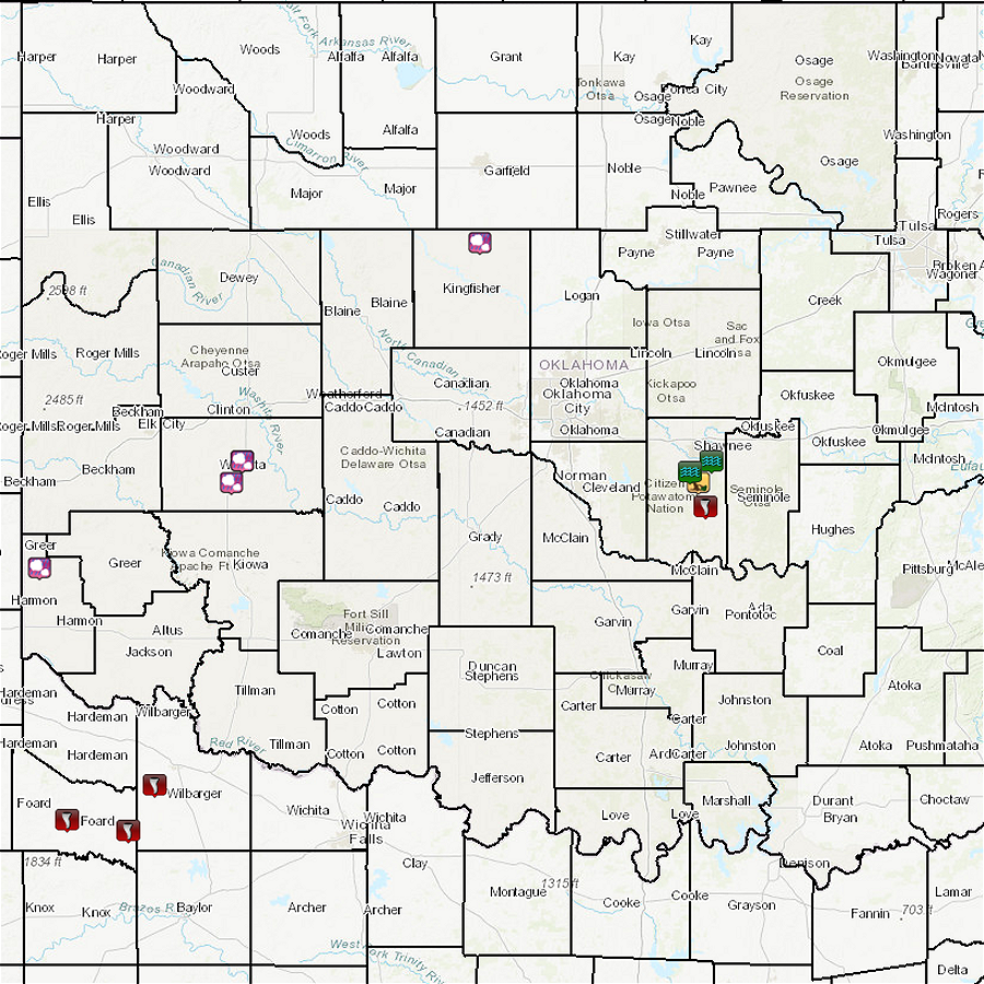
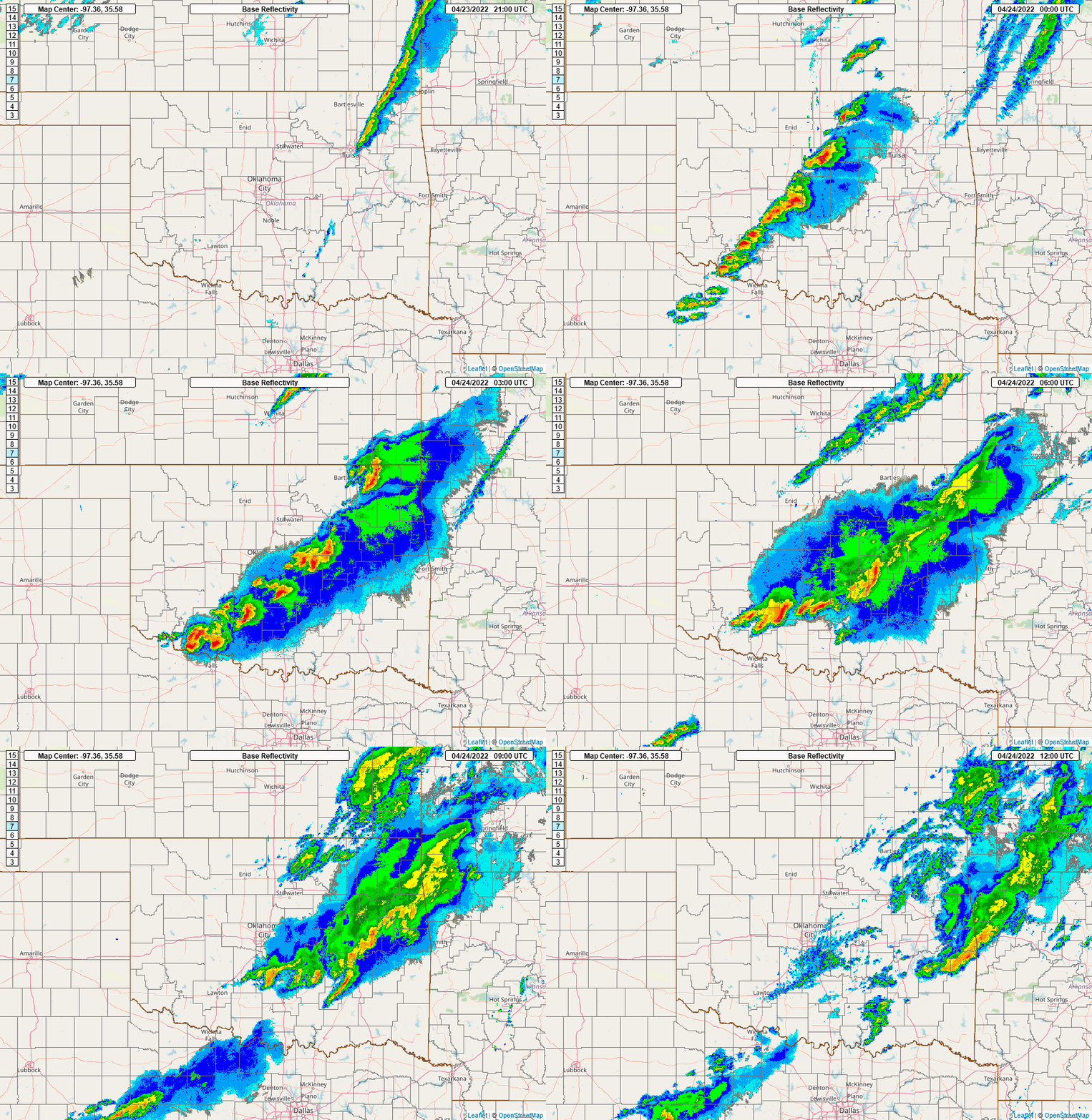
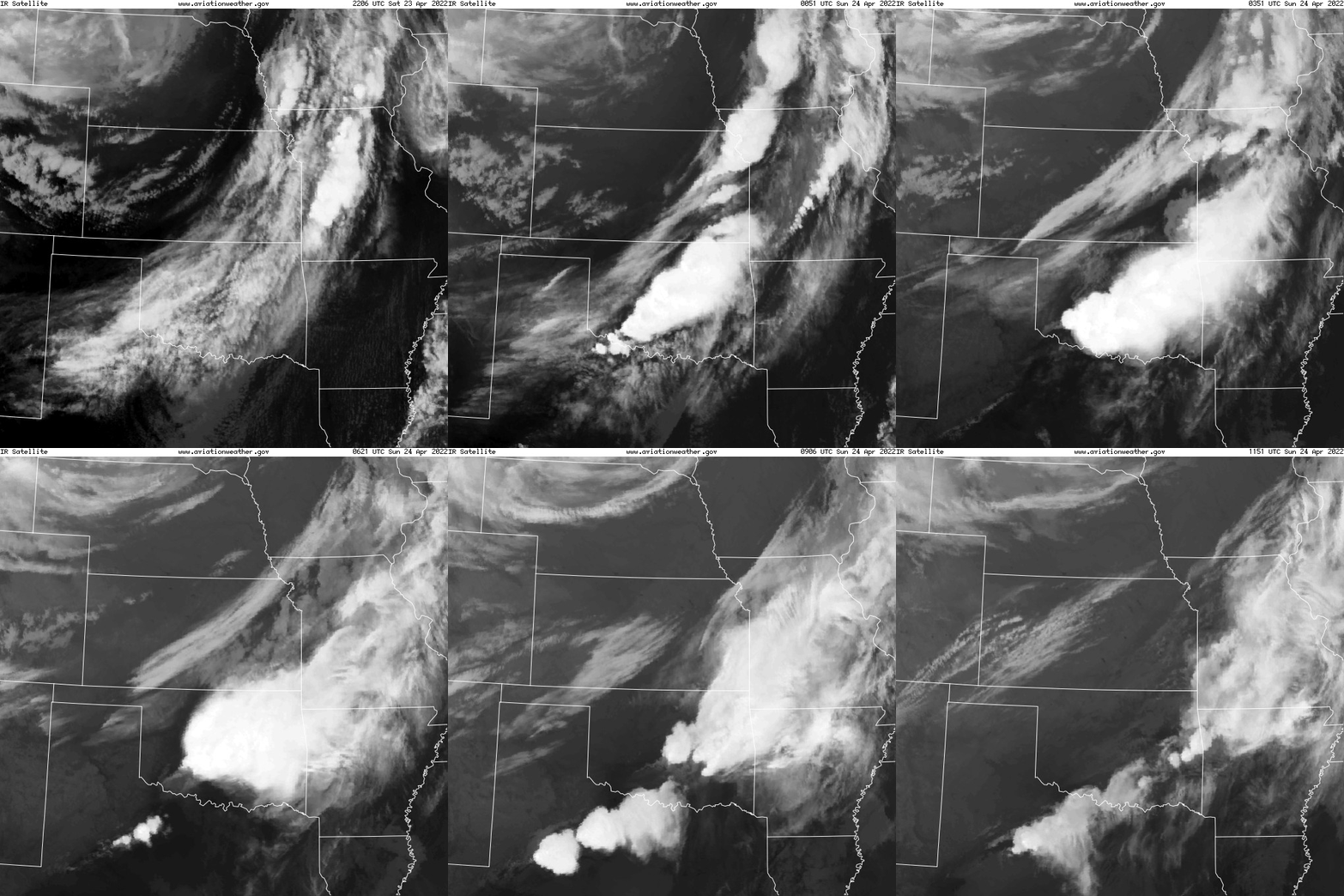
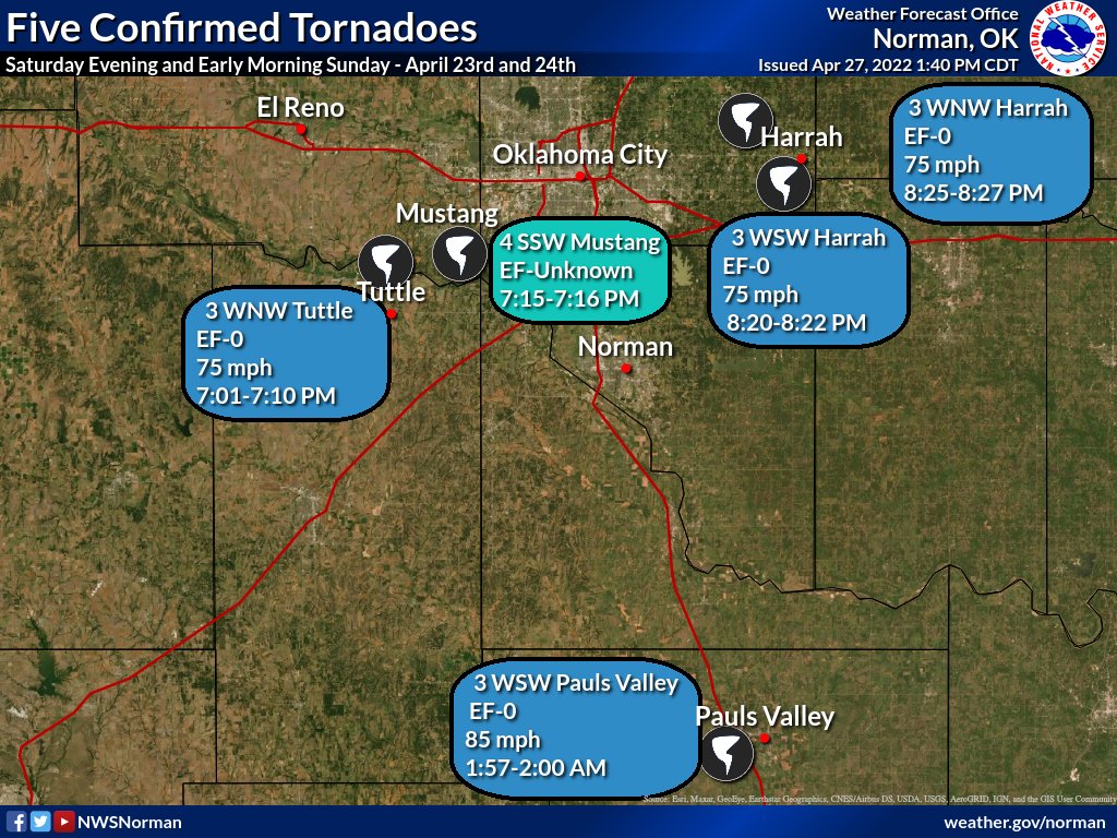
A cluster of supercell thunderstorms developed ahead of a stalling dryline across central Oklahoma in the early evening of April 23, 2022. The most impactful storm of this event moved across portions of the southern Oklahoma City metropolitan area and the adjacent suburbs of Tuttle, Mustang, Moore, and Harrah, OK. While this storm produced multiple tornadoes, all were weak (EF-0) and brief. Another weak tornado occurred early in the morning of April 24th just west of Pauls Valley, OK in Garvin County.
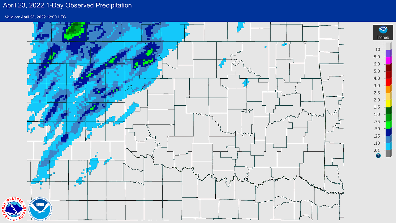
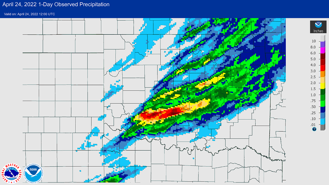
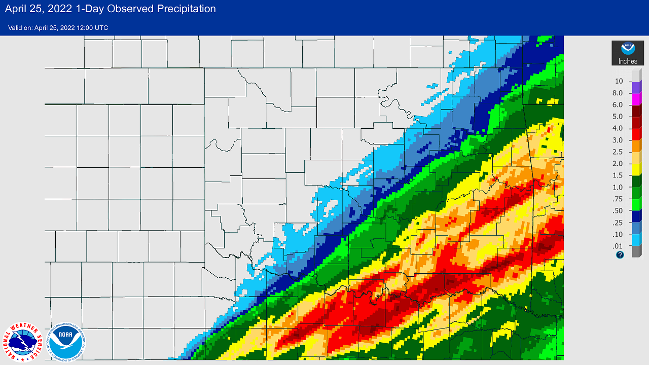
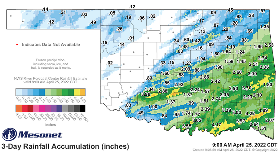
Heavy rainfall was another notable impact from this event, especially across south-central into southwestern Oklahoma. A corridor of 2 to 4-inch rainfall accumulations (with isolated pockets of 5 inches+) occurred from northern Comanche County through southern Grady County and into southern McClain County. This is where multiple heavy thunderstorms occurred from the afternoon of the April 23rd through the early morning of April 24th.
NOUS44 KOUN 271859
PNSOUN
OKZ004>048-050>052-TXZ083>090-280700-

Public Information Statement
National Weather Service Norman OK
159 PM CDT Wed Apr 27 2022

...NWS DAMAGE SURVEY FOR APRIL 23-24 2022 TORNADO EVENT...

.Overview...

On Saturday evening into early morning Sunday, several thunderstorms
occurred across Oklahoma and western north Texas. Multiple reports of
hail, wind damage, and tornadoes were received. Over the past several
days, National Weather Service teams have assessed the damage, radar
data, eyewitness accounts, and pictures from the storms.

Five tornadoes can be confirmed from the thunderstorms. Of the five,
four could be given a rating, while one occurred in the Canadian
River Valley and any damage was unaccessible by assessment teams.
The remaining four tornadoes have EF-0 damage.

Other areas of note from last Saturday were Lawton and near Stillwater.
In both of these cases, the damage is consistent with non-tornadic winds.
Damage in and near Pauls Valley was predominately from straight-line
downburst winds. However, the ground survey found evidence of a brief
tornado to the west of I-35 near Pauls Valley.

.Tuttle...

Rating:                 EF0
Estimated Peak Wind:    75 mph
Path Length /statute/:  3.75 miles
Path Width /maximum/:   30.0 yards
Fatalities:             0
Injuries:               0

Start Date:             04/23/2022
Start Time:             07:01 PM CDT
Start Location:         3 WNW Tuttle / Grady County / OK
Start Lat/Lon:          35.3106 / -97.8548

End Date:               04/23/2022
End Time:               07:10 PM CDT
End Location:           2 NNE Tuttle / Grady County / OK
End Lat/Lon:            35.32 / -97.7902

Survey Summary:
A tornado touched down northwest of Tuttle, north of State
Highway 37 and west of County Road 2890. The tornado moved
northeast and then east causing roof damage to an outbuilding and
tree damage near and south of Silver City Ridge Road before
dissipating east of Richland Road.

.Canadian River...

Rating:                 EF-Unknown
Estimated Peak Wind:    N/A
Path Length /statute/:  0.28 miles
Path Width /maximum/:   N/A
Fatalities:             0
Injuries:               0

Start Date:             04/23/2022
Start Time:             07:15 PM CDT
Start Location:         4 SSW Mustang / Canadian County / OK
Start Lat/Lon:          35.3321 / -97.7484

End Date:               04/23/2022
End Time:               07:16 PM CDT
End Location:           4 SSW Mustang / Canadian County / OK
End Lat/Lon:            35.3341 / -97.744

Survey Summary:
A tornado was observed from the weather observer at Will Rogers
World Airport looking southwest from the airport. This tornado
was near the Canadian River to the south-southwest of Mustang.
Any damage from this observed tornado was unable to be reached.

.Southwest of Harrah...

Rating:                 EF0
Estimated Peak Wind:    75 mph
Path Length /statute/:  0.80 miles
Path Width /maximum/:   30.0 yards
Fatalities:             0
Injuries:               0

Start Date:             04/23/2022
Start Time:             08:20 PM CDT
Start Location:         3 WSW Harrah / Oklahoma County / OK
Start Lat/Lon:          35.4691 / -97.2136

End Date:               04/23/2022
End Time:               08:22 PM CDT
End Location:           2 WSW Harrah / Oklahoma County / OK
End Lat/Lon:            35.4763 / -97.2026

Survey Summary:
A brief tornado developed to the southwest of Harrah and moved
northeast. Tree damage was observed along 7 Road and just
west of the Kickapoo Turnpike. This tornado was within a much
broader area of wind damage.

.Northwest of Harrah...

Rating:                 EF0
Estimated Peak Wind:    75 mph
Path Length /statute/:  0.64 miles
Path Width /maximum/:   20.0 yards
Fatalities:             0
Injuries:               0

Start Date:             04/23/2022
Start Time:             08:25 PM CDT
Start Location:         4 NE Choctaw / Oklahoma County / OK
Start Lat/Lon:          35.5342 / -97.2144

End Date:               04/23/2022
End Time:               08:27 PM CDT
End Location:           3 NE Choctaw / Oklahoma County / OK
End Lat/Lon:            35.525 / -97.2128

Survey Summary:
A brief tornado touched down about 4 miles northwest of Harrah and
moved south-southeast near Peebly Road between NE 63rd and NE
50th Streets. Some light tree damages was observed.

.Pauls Valley...

Rating:                 EF0
Estimated Peak Wind:    85 mph
Path Length /statute/:  0.26 mile
Path Width /maximum/:   50.0 yards
Fatalities:             0
Injuries:               0

Start Date:             04/24/2022
Start Time:             01:57 AM CDT
Start Location:         3 WSW Pauls Valley / Garvin County / OK
Start Lat/Lon:          34.7232 / -97.2652

End Date:               04/24/2022
End Time:               02:00 AM CDT
End Location:           2 WSW Pauls Valley / Garvin County / OK
End Lat/Lon:            34.7244 / -97.2609

Survey Summary:
A brief tornado occurred just southwest of Pauls Valley within a
much broader area of wind damage. Although much of the damage in
the Pauls Valley area indicated straight-line winds blowing from
west to east, debris indicated a small area of rotational winds
of a tornado near the intersection of County Road 3220, and Royal
Oaks Road which damaged a salon and pushed farm implements to the
west.

EF Scale: The Enhanced Fujita Scale classifies tornadoes into the
following categories:

EFU...Unknown...Damage unaccessible
EF0...Weak......65 to 85 mph
EF1...Weak......86 to 110 mph
EF2...Strong....111 to 135 mph
EF3...Strong....136 to 165 mph
EF4...Violent...166 to 200 mph
EF5...Violent...>200 mph

NOTE:
The information in this statement is preliminary and subject to
change pending final review of the events and publication in NWS
Storm Data.

$$

Fox/Lindley/Mahale/Smith/Speheger
|
| Tornadoes by Intensity | |||||||
|---|---|---|---|---|---|---|---|
| EFU | EF0 | EF1 | EF2 | EF3 | EF4 | EF5 | Total |
| 1 | 4 | 0 | 0 | 0 | 0 | 0 | 5 |
| Tornado Number |
Date | Time (CST) |
Length of Path (miles) |
Width of Path (yards) |
F-Scale | Killed | Injured | County | Location |
|---|---|---|---|---|---|---|---|---|---|
| 1 | 04/23/2022 | 1801-1810 | 4 | 30 | EF0 | 0 | 0 | Grady | 2;5 WNW - 2.4 NNE Tuttle |
| 2 | 04/23/2022 | 1815-1816 | 0.3 | 50 | EFU | 0 | 0 | Canadian | 4 SSW Mustang |
| 3 | 04/23/2022 | 1920-1922 | 0.8 | 30 | EF0 | 0 | 0 | Oklahoma | 3 WSW - 2 WSW Harrah |
| 4 | 04/23/2022 | 1925-1927 | 0.2 | 20 | EF0 | 0 | 0 | Oklahoma | 4 NW - 3.5 NW Harrah |
| 5 | 04/24/2022 | 0057-0100 | 0.3 | 50 | EF0 | 0 | 0 | Garvin | 3 WSW - 2 WSW Pauls Valley |
