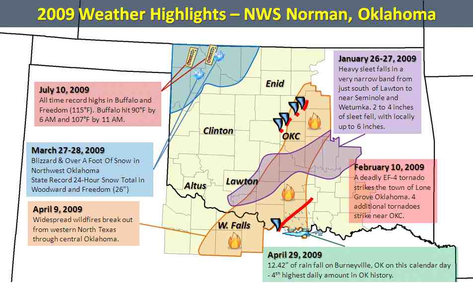
2009 started off with many major, high-impact weather events. However, by mid-May, the number of significant weather events declined rapidly. Throughout the summer and into fall, there were periodic severe weather episodes with primarily large hail and damaging winds, but none had quite the magnitude or impact of something like the February 10, 2009 tornado outbreak.

2009 started off with many major, high-impact weather events. However, by mid-May, the number of significant weather events declined rapidly. Throughout the summer and into fall, there were periodic severe weather episodes with primarily large hail and damaging winds, but none had quite the magnitude or impact of something like the February 10, 2009 tornado outbreak.
Here are some climate facts for parts of the area in 2009, using the National Climatic Data Center (NCDC) as the source for information:
|
With the surface cold front well south of the area, and an upper level low developing to the west of the area, warm and moist air began flowing from the Gulf of America northward and moving over this shallow cold air mass. Therefore, if you were in Oklahoma City and you went straight up into the air, you would first encounter a very cold air mass, followed by a relatively warm layer of air a few thousand feet up. This relatively warm layer was generally above the freezing mark, so any ice crystals melted as they were falling to the surface. However, the cold air near the ground was cold enough to re-freeze the water either as it hit the ground or other surfaces, or into small ice pellets as they fell through the cold air. The resulting precipitation across most of the area on January 26-27 was a combination of freezing rain and sleet. |
|
Because the majority of the precipitation was sleet rather than freezing rain, glaze on trees and power lines did not cause as much damage as other ice storms in recent past. However, the impact to travel was tremendous, and driving in the heavy sleet was extremely difficult. Several hundred automobile accidents occurred across the area. Several days later, satellite images still showed the sleet on the ground (left). |
|
Thunderstorms began developing by midday in parts of central Oklahoma, along the leading edge of deep moisture returning north from the Gulf of America, and a surface front. These storms produced numerous reports of large hail, some up to the size of baseballs (2.75" in diameter) in Piedmont, Yukon, Seward and Guthrie. However, most notably, the storms produced a combined 6 tornadoes, one of them a deadly EF-4 tornado that struck the town of Lone Grove, OK. Another strong tornado struck Edmond, OK earlier in the day. A detailed web page documenting this event is available on our website. |
|
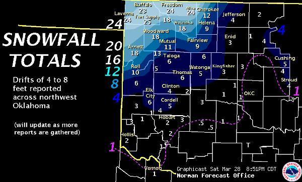
The following is an excerpt from the NWS Norman newsletter. A strong, late-season winter storm struck northwest Oklahoma with record setting snowfall on March 27-28, 2009. North winds began gusting over 40 mph when a cold front moved into northwest Oklahoma just after midnight on March 27th. At the same time, a powerful upper level storm moved out of New Mexico, and began to intensify over the Oklahoma and Texas Panhandles, spreading moisture and lift into northwest Oklahoma. Snow began around daybreak from Buffalo to Woodward and Gage. It was late afternoon, however, when snow became moderate and heavy, leading to significant accumulations. By early evening, some locations had already picked up over six inches of snow. The blustery winds also caused blowing and drifting which further reduced visibility and soon made traveling dangerous or impossible. Snow became more widespread overnight, and some thunder was even observed with the more intense squalls beneath the upper level storm. Snowfall rates of one to two inches per hour were reported, and locations north of a line from Roll to Mutual and Cherokee received between one and two feet of snow by sunrise. There was a sharp southern cut-off to the snowfall because of a stream of dry mid and upper level air that developed from the Texas South Plains up through southwest and central Oklahoma. Almost all roads in northwest Oklahoma were snow packed and impassable for some time. Some roads were said to be unidentifiable, and in other cases the snowpack was so tall and heavy that bulldozers could not clear a path. Drifts as high as 8 feet were reported in some locations. |
 |
|
This wildfire event was unusual in that it required Fire Warnings in rapid succession - almost at the pace that we are accustomed to issuing warnings for severe thunderstorms. Fire Warnings are a tool that emergency managers can use to disseminate evacuation orders via the NWS, using NOAA All Hazards Weather Radio. These messages describe the area threatened using well known street names, and provide instructions on which direction or along which roads people should travel to remove themselves from the path of the fire.
This event provided some unique challenges. While one meteorologist was dedicated to issuing Fire Warnings, there were also concerns with severe thunderstorms producing large hail in central Oklahoma, and the threat of damaging non-thunderstorm winds in western Oklahoma, behind a cold front. The diverse combination of hazards (shown in Graphicast to the left) made this a very high impact event across much of the area. The NWS in Norman also provided weather briefings by phone to firefighters, emergency managers, and media partners, almost continuously between 3:00 PM and 9:00 PM CDT. For more on this event, read the NWS Norman newsletter. |
|
The biggest story was probably the flooding, especially near the Red River on April 29th. That day, an intense line of thunderstorms bowed out and raced east across parts of southern Oklahoma. It produced estimated wind gusts as high as 90 to 95 mph in Pontotoc County. The southern end of the bow echo stalled and elongated in an east to west fashion, producing hours of torrential downpours near the Red River in southern Oklahoma. The result was an Oklahoma Mesonet observing station near Burneyville, OK (Love County) recording 12.89" of rain in around 18 hours. Most of this total - 12.42" of rain - fell on the calendar day April 29th. This total broke several records, including the daily record at Burneyville and the daily rainfall record for any Oklahoma Mesonet station since the network’s inception in 1994. Moreover, the single day total of 12.42 inches was sufficient, on its own, to make April 2009, the wettest month ever observed at the Burneyville station. When you add in the rest of April, the monthly total reached 15.36 inches. National Weather Service observations date back much farther than 1994, and the 12.42 inch daily rainfall at Burneyville ranks as the fourth highest single day amount in Oklahoma history. |
Several severe weather episodes hit the area in May. The most notable severe weather probably occurred on May 13th. Numerous thunderstorms developed that day along a cold front advancing into Oklahoma. One of the thunderstorms produced an EF-2 tornado that tracked from near Gracemont to near Anadarko, and severe straight-line winds in the city of Anadarko. Total monetary damages for the wind damage and tornado damage was estimated to be around $50 million.
No significant weather events really stood out from June through November 2009. There were occasional severe weather episodes during the summer months, and a handful in the fall as well. No major winter weather was observed through this timeframe either. From June onwards, there were only 6 tornadoes - all of them relatively weak and rated either an EF-0 or EF-1 on the Enhanced Fujita Scale. On June 10th, there were numerous wind gusts of around 60 to 70 mph associated with a complex of thunderstorms that moved across parts of southern Oklahoma. A few of the wind gusts topped 80 mph, and were measured by an anemometer. This was probably one of the more notable severe weather events in the latter part of the year. Additionally, there was a spell of extremely hot weather in early July. Many of the first two weeks of July saw widespread triple digit heat in the area.
|
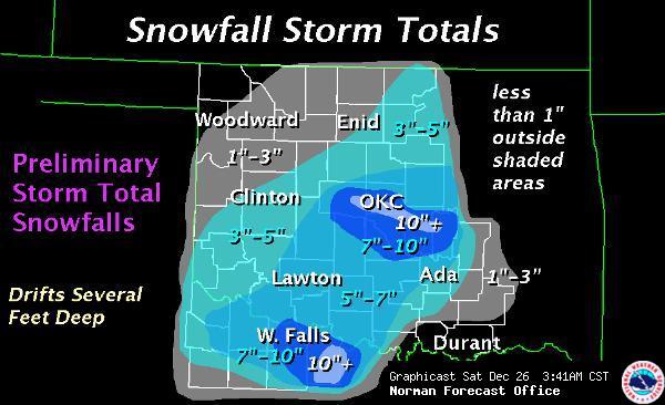
Most of December was quiet prior to a major blizzard that struck the area on December 24, 2009. Heavy snow combined with extremely gusty winds to severely reduce visibilities for many hours. Oklahoma City recorded over a foot of snow in this storm, with a peak wind gust of 62 mph. The measured snowfall total broke several records at Oklahoma City. The amount shattered the record snowfall for the calendar day December 24th (previously 2.5 inches in 1914). It was also the greatest snowfall measured in a 24-hour period, breaking the previous record of 11.3 inches on March 19, 1924. Finally, it was the greatest storm total snowfall, breaking the previous record of 12.1 inches from January 5-7, 1988. For more details on the storm, visit our storm write-up here. |
 |