Extremely critical fire weather concerns for portions of the southern High Plans as strong wind and very dry conditions could result in rapid spread of any fires. Meanwhile, severe thunderstorms are expected once again across areas of the Central and Southern Plains, then spreading in the Mississippi Valley regions on Monday. Damaging winds, very large hail and strong tornadoes are possible. Read More >

| Foard County, TX Tornadoes Prior to 1950 | |||||||||
| # | Date | Time (CST) |
Path Length (miles) |
Path Width (yards) |
F-Scale | Killed | Injured | County | Path |
|---|---|---|---|---|---|---|---|---|---|
| 04/28/1942 | 2130 | 1760 | 11 | 250 | Foard | Crowell | |||
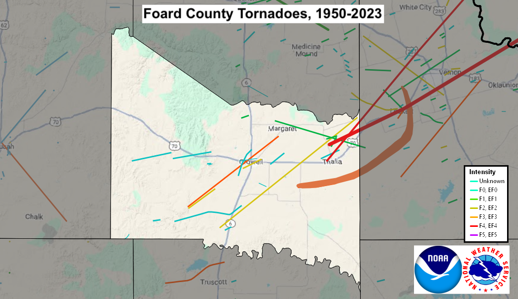
| Foard County, TX Tornadoes (1950-Present*) | |||||||||
| # | Date | Time (CST) |
Path Length (miles) |
Path Width (yards) |
F-Scale | Killed | Injured | County | Path |
| 1 | 05/01/1954 | 1415 | 69 | 440 | F4 | 0 | 2 | Foard TX/ Wilbarger TX/ Tillman OK/ Kiowa OK | Crowell and Elliot areas TX - E of Tipton OK - near Snyder OK [No injuries in Oklahoma] |
| 2 | 04/17/1976 | 0200 | 15 | 150 | F3 | 0 | 1 | Foard | 10 SW Crowell- NW part of Crowell - NE of Crowell |
| 3 | 04/17/1976 | 0200 | 4 | 150 | F2 | 0 | 0 | Foard | 10 SW- 6 SW Crowell |
| 4 | 05/18/1978 | 2015 | 1.5 | 20 | F? | 0 | 0 | Foard | 1 W Crowell- Crowell |
| 5 | 04/10/1979 | 1505 | 22 | 10 | F2 | 0 | 1 | Foard | 2 S Foard City- 3 N Rayland |
| 6 | 04/10/1979 | 1520 | 40 | 880 | F4 | 11 | 68 | Foard TX/ Wilbarger TX/ Tillman OK | 2 N Thalia TX- Lockett TX- Vernon TX- ENE of Davidson OK [One injury in Oklahoma. 11 Fatalities and 67 injuries in Texas] |
| 7 | 04/10/1979 | 1520 | 3 | 100 | F0 | 0 | 0 | Foard | 11 E Crowell |
| 8 | 05/20/1979 | 1336 | 0.1 | 10 | F1 | 0 | 0 | Foard | 3 N Thalia |
| 9 | 06/08/1979 | 2000 | 0.1 | 10 | F1 | 0 | 0 | Foard | 6 N Crowell |
| 10 | 04/25/1980 | 1130 | 12 | 77 | F1 | 0 | 0 | Foard/ Wilbarger | 1 NW Maragret - Margaret - 10 ESE Margaret |
| 11 | 05/16/1986 | 1848 | 5 | 200 | F0 | 0 | 0 | Foard | ~15 W Crowell |
| 12 | 05/16/1986 | 1910 | 5 | 150 | F0 | 0 | 0 | Foard | 10 W Crowell |
| 13 | 08/17/1994 | 2045 | 2 | 40 | F2 | 0 | 0 | Foard | Crowell |
| 14 | 05/16/1999 | 1939-1940 | 0.5 | 50 | F1 | 0 | 0 | Foard | 2 N - 2.5 N Thalia |
| 15 | 04/30/2000 | 1501 | 0.2 | 50 | F0 | 0 | 0 | Foard | 6 W Crowell |
| 16 | 04/30/2000 | 1520-1530 | 3 | 50 | F0 | 0 | 0 | Foard | 2 SW - 1 N Crowell |
| 17 | 04/30/2000 | 1527-1534 | 2 | 50 | F0 | 0 | 0 | Foard | 2 E - 4 ENE Crowell |
| 18 | 09/14/2005 | 1708-1713 | 1 | 40 | F0 | 0 | 0 | Foard | 2.5 SE Foard City |
| 19 | 05/30/2012 | 1727-1730 | 2 | 400 | EF0 | 0 | 0 | Foard | 15 WSW Crowell |
| 20 | 05/28/2015 | 1413-1414 | 0.5 | 50 | EF0 | 0 | 0 | Foard | 6 W Crowell |
| 21 | 05/04/2022 | 1800-1819 | 8 | 100 | EF? | 0 | 0 | King/ Foard | 7 SE Chalk - 19 WSW Crowell |
| 22 | 05/04/2022 | 1840-1856 | 9 | 100 | EF0 | 0 | 0 | Foard | 13 SW - 6 SSW Crowell |
| 23 | 05/04/2022 | 1911-1913 | 1 | 50 | EF? | 0 | 0 | Foard | 3 SSE - 4 SSE Crowell |
| 24 | 05/04/2022 | 1925-2023 | 23 | 600 | EF3 | 0 | 0 | Foard/ Wilbarger | 5 SW Thalia - Lockett - 3 N Lockett |
Records taken from the Storm Prediction Center archive data, "Storm Data", and data from the National Weather Service office in Norman. Data modified as described in NOAA Tech Memo NWS SR-209 (Speheger, D., 2001: "Corrections to the Historic Tornado Database").
Historic data, especially before 1950, are likely incomplete.