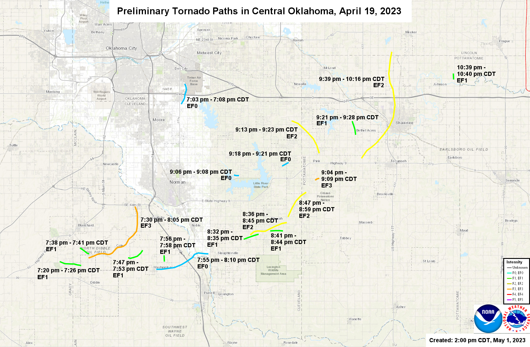
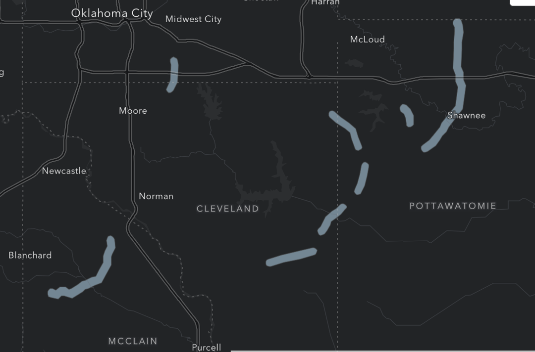
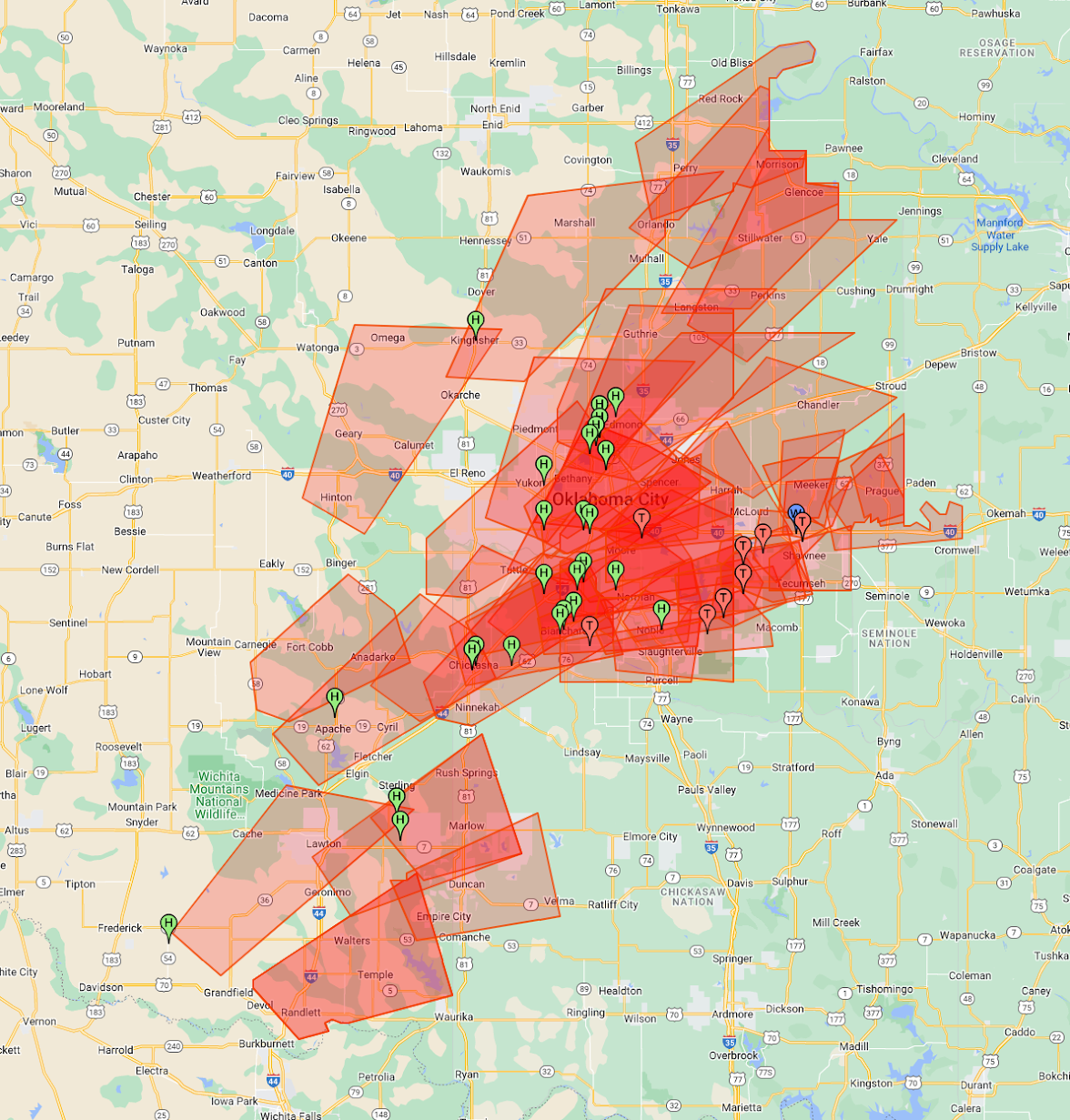
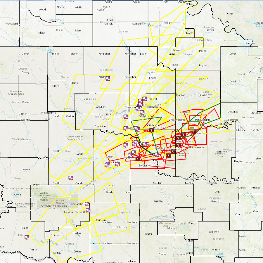
During the late afternoon hours of April 19, 2023, thunderstorms formed along a dryline in southwestern and central Oklahoma, and quickly reached severe levels. These supercell thunderstorms eventually produced large hail of 1 to 3 inches in diameter and 18 tornadoes in the area. One strong and damaging tornado killed 1 person in McClain County near the town of Cole. More tornadoes occurred near Tinker AFB, Etowah, Pink, Bethel Acres, and Shawnee.
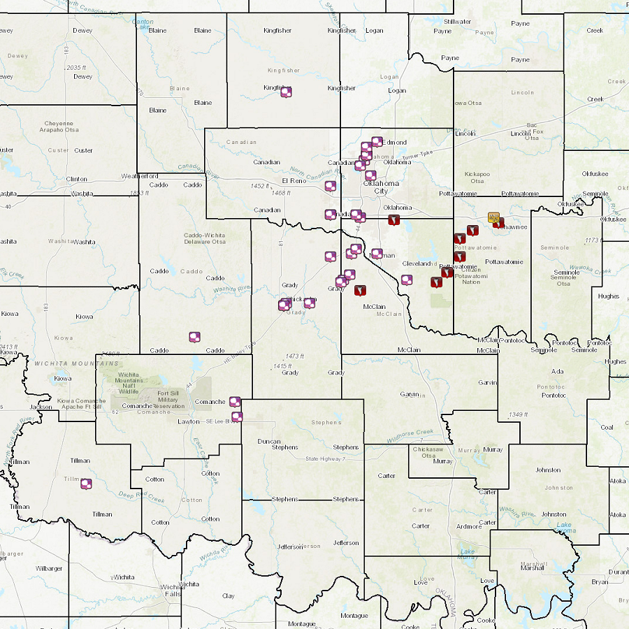
Teams conducted storm damage surveys in and near Cole, the Shawnee-Bethel Acres area, the Etowah-Pink-Stella area, and near Lake Stanley Draper on April 20-21, 2023. Based on their research, 18 tornadoes had been documented for the event, and preliminary EF Scale ratings had been assigned to these 18 tornadoes.
A map and link to KMZ file for the storm survey areas are available below. More information will be provided as it becomes available.
A broad, longwave trough was present (aloft) across the western-half of the continental United States (CONUS) on April 19, 2023. At the surface, a low-pressure center was slowly organizing/strengthening across portions of central Kansas, with a dryline extending southward towards west-central Texas. Plentiful insolation across much of the area, combined with increasing near-surface moisture, lead to the development of an unstable boundary layer (high amounts of surface-based instability) favorable for severe weather.
The greatest forecast challenge with this event was whether storms would develop due to a strong cap (layer of warm air) aloft. Additionally, if a few storms did ultimately develop, would they be “surface-based” (i.e. capable of producing tornadoes & damaging winds)? The 1900 UTC/2:00 PM CDT special balloon release from the office revealed that the cap was much weaker than expected by the early afternoon. Combined with a deep dryline circulation, along with passage of well-timed shortwave across this boundary, a few robust supercell thunderstorms developed across central Oklahoma into the evening.
Multiple instances of large to very large (>2 inches) hail were observed with the most dominant supercells into the evening hours. The largest observed hailstone during the event was 3 inches (teacup sized) near Amber, OK (Grady County) and Newcastle, OK (McClain County). By early evening, as the low-level jet began to intensify, a pair of supercell thunderstorms became tornadic. The first tornado with this event produced light (EF-0) damage near Tinker Air Force Base. The most damaging and deadly storm of the day rapidly organized across McClain County by 7 PM CDT. An intense (EF-3) tornado did extensive damage in/near the town of Cole, OK, with 3 “satellite” tornadoes (of EF-1 strength) observed near the path of the “Cole” tornado. This storm went on to produce 7 additional tornadoes, including multiple significant (EF-2+) tornadoes across Cleveland and Pottawatomie counties. Another notable tornado, with widespread impact, affected western portions of Shawnee, OK late in the evening. Another interesting aspect of this event was that, given the presence of a strong low-level jet along with slow storm motions, tornadoes tended to track to the north and west with time during their lifespan.
NOUS44 KOUN 271710
PNSOUN
OKZ004>048-050>052-280515-

Public Information Statement
National Weather Service Norman OK
1210 PM CDT Thu Apr 27 2023

...NWS Damage Survey for 4/19/23 Tornado Event - Update #3...

.Update...Separated Etowah tornado into two distinct paths, added
four additional tornadoes (one NE of Washington, two west of
Etowah, one NE of Johnson or near Garden Grove), reduced length of
the EF3 tornado south of Pink.

.Tornado Southwest of Tinker Air Force Base...

Rating:                 EF0
Estimated Peak Wind:    80 to 85 mph
Path Length /statute/:  3 miles
Path Width /maximum/:   250 yards
Fatalities:             0
Injuries:               0

Start Date:             04/19/2023
Start Time:             07:03 PM CDT
Start Location:         3 SSW Tinker Air Force Base / Cleveland County / OK
Start Lat/Lon:          35.37 / -97.42

End Date:               04/19/2023
End Time:               07:08 PM CDT
End Location:           1 WSW Tinker Air Force Base / Oklahoma County / OK
End Lat/Lon:            35.41 / -97.41

.Tornado Northwest of Dibble...

Rating:                 EF1
Estimated Peak Wind:    90 to 95 mph
Path Length /statute/:  3 miles
Path Width /maximum/:   200 yards
Fatalities:             0
Injuries:               0

Start Date:             04/19/2023
Start Time:             07:20 PM CDT
Start Location:         3 SE Middleberg / Grady County / OK
Start Lat/Lon:          35.08 / -97.70

End Date:               04/19/2023
End Time:               07:26 PM CDT
End Location:           3 NNW Dibble / McClain County / OK
End Lat/Lon:            35.07 / -97.65

.Cole Tornado...

Rating:                 EF3
Estimated Peak Wind:    150 to 155 mph
Path Length /statute/:  11 miles
Path Width /maximum/:   1200 yards
Fatalities:             1
Injuries:               Unknown

Start Date:             04/19/2023
Start Time:             07:30 PM CDT
Start Location:         3 N Dibble / McClain County / OK
Start Lat/Lon:          35.08 / -97.63

End Date:               04/19/2023
End Time:               08:05 PM CDT
End Location:           3 NW Goldsby / McClain County / OK
End Lat/Lon:            35.18 / -97.53

.Tornado West of Cole...

Rating:                 EF1
Estimated Peak Wind:    90 to 95 mph
Path Length /statute/:  1.5 miles
Path Width /maximum/:   200 yards
Fatalities:             0
Injuries:               0

Start Date:             04/19/2023
Start Time:             07:38 PM CDT
Start Location:         2 S Blanchard / McClain County / OK
Start Lat/Lon:          35.10 / -97.65

End Date:               04/19/2023
End Time:               07:41 PM CDT
End Location:           3 WSW Cole / McClain County / OK
End Lat/Lon:            35.09 / -97.63

.Tornado Southeast of Cole...

Rating:                 EF1
Estimated Peak Wind:    90 to 95 mph
Path Length /statute/:  2 miles
Path Width /maximum/:   400 yards
Fatalities:             0
Injuries:               0

Start Date:             04/19/2023
Start Time:             07:47 PM CDT
Start Location:         2 SE Cole / McClain County / OK
Start Lat/Lon:          35.08 / -97.54

End Date:               04/19/2023
End Time:               07:53 PM CDT
End Location:           3 NNW Washington / McClain County / OK
End Lat/Lon:            35.10 / -97.51

.Washington to Slaughterville Tornado...

Rating:                 EF0
Estimated Peak Wind:    80 to 85 mph
Path Length /statute/:  7 miles
Path Width /maximum/:   400 yards
Fatalities:             0
Injuries:               0

Start Date:             04/19/2023
Start Time:             07:55 PM CDT
Start Location:         Washington / McClain County / OK
Start Lat/Lon:          35.06 / -97.48

End Date:               04/19/2023
End Time:               08:15 PM CDT
End Location:           1 W Slaughterville / Cleveland County / OK
End Lat/Lon:            35.09 / -97.36

.Tornado Northeast of Washington...

Rating:                 EF-unknown
Estimated Peak Wind:    unknown
Path Length /statute/:  0.25 miles
Path Width /maximum/:   50 yards
Fatalities:             0
Injuries:               0

Start Date:             04/19/2023
Start Time:             07:57 PM CDT
Start Location:         2 NE Washington / McClain County / OK
Start Lat/Lon:          35.08 / -97.46

End Date:               04/19/2023
End Time:               07:58 PM CDT
End Location:           2 NE Washington / McClain County / OK
End Lat/Lon:            35.07 / -97.46


.Etowah Tornado...

Rating:                 EF2
Estimated Peak Wind:    130 to 135 mph
Path Length /statute/:  6 miles
Path Width /maximum/:   700 yards
Fatalities:             0
Injuries:               Unknown

Start Date:             04/19/2023
Start Time:             08:32 PM CDT
Start Location:         4 ENE Slaughterville / Cleveland County / OK
Start Lat/Lon:          35.12 / -97.28

End Date:               04/19/2023
End Time:               08:45 PM CDT
End Location:           1 NNW Etowah / Cleveland County / OK
End Lat/Lon:            35.15 / -97.18

.Tornado #1 West of Etowah...

Rating:                 EF1
Estimated Peak Wind:    90 to 95 mph
Path Length /statute/:  0.8 miles
Path Width /maximum/:   150 yards
Fatalities:             0
Injuries:               0

Start Date:             04/19/2023
Start Time:             08:38 PM CDT
Start Location:         4 W Etowah / Cleveland County / OK
Start Lat/Lon:          35.13 / -97.25

End Date:               04/19/2023
End Time:               08:40 PM CDT
End Location:           3 W Etowah / Cleveland County / OK
End Lat/Lon:            35.13 / -97.23

.Tornado #2 West of Etowah...

Rating:                 EF1
Estimated Peak Wind:    105 to 110 mph
Path Length /statute/:  1.7 miles
Path Width /maximum/:   50 yards
Fatalities:             0
Injuries:               0

Start Date:             04/19/2023
Start Time:             08:41 PM CDT
Start Location:         2 W Etowah / Cleveland County / OK
Start Lat/Lon:          35.13 / -97.21

End Date:               04/19/2023
End Time:               08:44 PM CDT
End Location:           1 W Etowah / Cleveland County / OK
End Lat/Lon:            35.13 / -97.18

.Tornado Northeast of Etowah...

Rating:                 EF2
Estimated Peak Wind:    130 to 135 mph
Path Length /statute/:  4.1 miles
Path Width /maximum/:   2200 yards
Fatalities:             0
Injuries:               Unknown

Start Date:             04/19/2023
Start Time:             08:47 PM CDT
Start Location:         2 N Etowah / Cleveland County / OK
Start Lat/Lon:          35.16 / -97.17

End Date:               04/19/2023
End Time:               08:59 PM CDT
End Location:           4 S Pink / Pottawatomie County / OK
End Lat/Lon:            35.21 / -97.13

.Tornado South of Pink...

Rating:                 EF3
Estimated Peak Wind:    140 to 145 mph
Path Length /statute/:  0.6 miles
Path Width /maximum/:   250 yards
Fatalities:             0
Injuries:               0

Start Date:             04/19/2023
Start Time:             09:04 PM CDT
Start Location:         2 SSE Pink / Pottawatomie County / OK
Start Lat/Lon:          35.23 / -97.11

End Date:               04/19/2023
End Time:               09:09 PM CDT
End Location:           2 SSE Pink / Pottawatomie County / OK
End Lat/Lon:            35.23 / -97.10

.Tornado Northwest of Lake Thunderbird...

Rating:                 EF0
Estimated Peak Wind:    75 to 80 mph
Path Length /statute/:  0.7 miles
Path Width /maximum/:   60 yards
Fatalities:             0
Injuries:               0

Start Date:             04/19/2023
Start Time:             09:06 PM CDT
Start Location:         4 W Lake Thunderbird / Cleveland County / OK
Start Lat/Lon:          35.24 / -97.30

End Date:               04/19/2023
End Time:               09:08 PM CDT
End Location:           3 WNW Lake Thunderbird / Cleveland County / OK
End Lat/Lon:            35.24 / -97.29

.Tornado North of Pink...

Rating:                 EF2
Estimated Peak Wind:    120 to 125 mph
Path Length /statute/:  6 miles
Path Width /maximum/:   700 yards
Fatalities:             0
Injuries:               0

Start Date:             04/19/2023
Start Time:             09:13 PM CDT
Start Location:         2 NE Pink / Pottawatomie County / OK
Start Lat/Lon:          35.28 / -97.10

End Date:               04/19/2023
End Time:               09:23 PM CDT
End Location:           3 ENE Stella / Cleveland County / OK
End Lat/Lon:            35.34 / -97.17

.Tornado Northeast of Little Axe...

Rating:                 EF0
Estimated Peak Wind:    75 to 80 mph
Path Length /statute/:  1 mile
Path Width /maximum/:   75 yards
Fatalities:             0
Injuries:               0

Start Date:             04/19/2023
Start Time:             09:18 PM CDT
Start Location:         2 NE Little Axe / Cleveland County / OK
Start Lat/Lon:          35.25 / -97.19

End Date:               04/19/2023
End Time:               09:21 PM CDT
End Location:           3 NE Little Axe / Cleveland County / OK
End Lat/Lon:            35.26 / -97.17

.Bethel Acres Tornado...

Rating:                 EF1
Estimated Peak Wind:    86 to 90 mph
Path Length /statute/:  1.8 miles
Path Width /maximum/:   400 yards
Fatalities:             0
Injuries:               0

Start Date:             04/19/2023
Start Time:             09:21 PM CDT
Start Location:         2 ENE Bethel Acres / Pottawatomie County / OK
Start Lat/Lon:          35.31 / -97.02

End Date:               04/19/2023
End Time:               09:28 PM CDT
End Location:           3 NE Bethel Acres / Pottawatomie County / OK
End Lat/Lon:            35.34 / -97.03

.Shawnee Tornado...

Rating:                 EF2
Estimated Peak Wind:    130 to 135 mph
Path Length /statute/:  15.5 miles
Path Width /maximum/:   2300 yards
Fatalities:             0
Injuries:               Unknown

Start Date:             04/19/2023
Start Time:             09:39 PM CDT
Start Location:         3 SE Bethel Acres / Pottawatomie County / OK
Start Lat/Lon:          35.27 / -97.00

End Date:               04/19/2023
End Time:               10:16 PM CDT
End Location:           2 NNW Aydelotte / Lincoln County / OK
End Lat/Lon:            35.47 / -96.93

.Tornado Northwest of Garden Grove/Northeast of Johnson...

Rating:                 EF1
Estimated Peak Wind:    95 to 100 mph
Path Length /statute/:  0.4 miles
Path Width /maximum/:   50 yards
Fatalities:             0
Injuries:               0

Start Date:             04/19/2023
Start Time:             10:39 PM CDT
Start Location:         3 ENE Johnson / Pottawatomie County / OK
Start Lat/Lon:          35.43 / -96.79

End Date:               04/19/2023
End Time:               10:40 PM CDT
End Location:           3 ENE Johnson / Pottawatomie County / OK
End Lat/Lon:            35.42 / -96.79

&&

EF Scale: The Enhanced Fujita Scale classifies tornadoes into the
following categories:

EF0...Weak......65 to 85 mph
EF1...Weak......86 to 110 mph
EF2...Strong....111 to 135 mph
EF3...Strong....136 to 165 mph
EF4...Violent...166 to 200 mph
EF5...Violent...>200 mph

NOTE:
The information in this statement is preliminary and subject to
change pending final review of the events and publication in
NWS Storm Data.


$$

..speg.
|

| Tornadoes by Intensity | |||||||
|---|---|---|---|---|---|---|---|
| EFU | EF0 | EF1 | EF2 | EF3 | EF4 | EF5 | Total |
| 0 | 4 | 8 | 4 | 2 | 0 | 0 | 18 |
| Tornado Number |
Date | Time (CST) |
Length of Path (miles) |
Width of Path (yards) |
F-Scale | Killed | Injured | County | Location |
|---|---|---|---|---|---|---|---|---|---|
| 1 | 04/19/2023 | 1803-1808 | 3 | 250 | EF0 | 0 | 0 | Cleveland/ Oklahoma | 3 SSW - 1 WSW Tinker AFB |
| 2 | 04/19/2023 | 1820-1826 | 3 | 200 | EF1 | 0 | 0 | Grady/ McClain | 3 SE Middleberg - 3 NNW Dibble |
| 3 | 04/19/2023 | 1830-1905 | 11 | 1200 | EF3 | 1 | McClain | 3 N Dibble - Cole - 3 NW Goldsby | |
| 4 | 04/19/2023 | 1838-1841 | 1.5 | 200 | EF1 | 0 | 0 | McClain | 2 S Blanchard - 3 WSW Cole |
| 5 | 04/19/2023 | 1847-1853 | 2 | 400 | EF1 | 0 | 0 | McClain | 2 SE Cole - 3 NNW Washington |
| 6 | 04/19/2023 | 1855-1910 | 7 | 400 | EF0 | 0 | 0 | McClain/ Cleveland | just E of Washington - 1 W Slaughterville |
| 7 | 04/19/2023 | 1856-1858 | 0.8 | 50 | EF1 | 0 | 0 | McClain | 2.5 NE - 2 NE Washington |
| 8 | 04/19/2023 | 1932-1935 | 2 | 150 | EF1 | 0 | 0 | Cleveland | 4 NE Slaughterville - 2 SW Etowah |
| 9 | 04/19/2023 | 1936-1945 | 5 | 700 | EF2 | 0 | 0 | Cleveland | 4 NE Slaughterville - 1 NNW Etowah |
| 10 | 04/19/2023 | 1941-1944 | 1.7 | 50 | EF1 | 0 | 0 | Cleveland | 1 S - 2 SE Etowah |
| 11 | 04/19/2023 | 1947-1959 | 4 | 2200 | EF2 | 0 | 0 | Cleveland | 2 ENE Etowah - 4 S Pink |
| 12 | 04/19/2023 | 2004-2009 | 0.6 | 250 | EF3 | 0 | 0 | Pottawatomie | 2 SSE Pink |
| 13 | 04/19/2023 | 2006-2008 | 0.7 | 60 | EF0 | 0 | 0 | Cleveland | east Norman (NW of 108th Ave SE and Alameda) |
| 14 | 04/19/2023 | 2013-2023 | 6 | 700 | EF2 | 0 | 0 | Pottawatomie/ Cleveland | 2 NW Pink - 3 ENE Stella |
| 15 | 04/19/2023 | 2018-2021 | 1 | 75 | EF0 | 0 | Cleveland | 2 NE - 3 NE Little Axe | |
| 16 | 04/19/2023 | 2021-2028 | 1.8 | 400 | EF1 | 0 | 0 | Pottawatomie | 2 ENE - 3 NE Bethel Acres |
| 17 | 04/19/2023 | 2039-2116 | 15.5 | 2300 | EF2 | 0 | Pottawatomie/ Lincoln | 3 SE Bethel Acres - Shawnee - 2 NNW Aydelotte | |
| 18 | 04/19/2023 | 2139-2140 | 0.8 | 50 | EF1 | 0 | 0 | Pottawatomie | 1 NW - 1 W Garden Grove (3 NE - 3 ENE Johnson) |
| Report Date |
Report Time (CST) |
Location | County | State | Event Type |
Mag. | Source | Lat. | Lon. | Remark |
|---|---|---|---|---|---|---|---|---|---|---|
| 4/19/2023 | 16:04 | Chickasha | Grady | OK | Hail | 1.00 in. | Public | 35.04 | -97.94 | |
| 4/19/2023 | 16:06 | Chickasha | Grady | OK | Hail | 1.25 in. | Public | 35.04 | -97.94 | |
| 4/19/2023 | 16:07 | 1 NE Chickasha | Grady | OK | Hail | 1.25 in. | Public | 35.05 | -97.93 | |
| 4/19/2023 | 16:08 | 2 N Lake Lawtonka | Comanche | OK | Hail | 1.00 in. | Public | 34.79 | -98.51 | Report from mPING: quarter (1.00 in.). |
| 4/19/2023 | 16:18 | Chickasha | Grady | OK | Hail | 1.75 in. | Public | 35.04 | -97.94 | |
| 4/19/2023 | 16:20 | 2 N Apache | Caddo | OK | Hail | 1.25 in. | Public | 34.92 | -98.36 | Report from mPING: half dollar (1.25 in.). |
| 4/19/2023 | 16:31 | 6 WSW Valley Brook | Oklahoma | OK | Hail | 1.00 in. | Public | 35.38 | -97.58 | |
| 4/19/2023 | 16:37 | Will Rogers World Airport | Oklahoma | OK | Hail | 1.00 in. | Official NWS Obs | 35.40 | -97.60 | |
| 4/19/2023 | 16:37 | 1 E Cement | Caddo | OK | Hail | 1.00 in. | Public | 34.93 | -98.11 | Report from mPING: quarter (1.00 in.). |
| 4/19/2023 | 16:39 | Mustang | Canadian | OK | Hail | 1.00 in. | Public | 35.39 | -97.72 | |
| 4/19/2023 | 16:40 | Mustang | Canadian | OK | Hail | 1.00 in. | Public | 35.39 | -97.72 | |
| 4/19/2023 | 16:41 | Blanchard | McClain | OK | Hail | 1.00 in. | Public | 35.14 | -97.66 | |
| 4/19/2023 | 16:45 | 2 N The Village | Oklahoma | OK | Hail | 1.25 in. | Public | 35.60 | -97.56 | Report from mPING: half dollar (1.25 in.). |
| 4/19/2023 | 16:45 | 1 SE Nichols Hills | Oklahoma | OK | Hail | 1.00 in. | Public | 35.54 | -97.53 | |
| 4/19/2023 | 16:46 | 3 NW Blanchard | Grady | OK | Hail | 2.75 in. | Public | 35.18 | -97.69 | Report from mPING: baseball (2.75 in.). |
| 4/19/2023 | 16:47 | 2 NE Blanchard | McClain | OK | Hail | 2.00 in. | Trained Spotter | 35.16 | -97.63 | |
| 4/19/2023 | 16:48 | Fort Cobb | Caddo | OK | Hail | 0.75 in. | Public | 35.10 | -98.44 | Report from mPING: dime (0.75 in.). |
| 4/19/2023 | 16:49 | 4 N The Village | Oklahoma | OK | Hail | 1.50 in. | Public | 35.62 | -97.55 | |
| 4/19/2023 | 16:49 | 3 N The Village | Oklahoma | OK | Hail | 1.50 in. | Public | 35.62 | -97.55 | |
| 4/19/2023 | 16:50 | 1 ENE Blanchard | McClain | OK | Hail | 1.75 in. | NWS Employee | 35.15 | -97.64 | |
| 4/19/2023 | 16:50 | 3 W Edmond | Oklahoma | OK | Hail | 2.00 in. | Public | 35.64 | -97.53 | Report from mPING: hen egg (2.00 in.). |
| 4/19/2023 | 16:52 | Bridge Creek | Grady | OK | Hail | 2.25 in. | Public | 35.23 | -97.72 | |
| 4/19/2023 | 16:54 | Fort Cobb | Caddo | OK | Hail | 1.00 in. | Public | 35.10 | -98.44 | Report from mPING: quarter (1.00 in.). |
| 4/19/2023 | 16:55 | 2 W Edmond | Oklahoma | OK | Hail | 2.00 in. | Public | 35.66 | -97.51 | Report from mPING: hen egg (2.00 in.). |
| 4/19/2023 | 16:55 | 1 WSW Newcastle | McClain | OK | Hail | 1.75 in. | Public | 35.24 | -97.62 | |
| 4/19/2023 | 16:55 | 1 NW Edmond | Oklahoma | OK | Hail | 1.75 in. | Emergency Mngr | 35.67 | -97.50 | |
| 4/19/2023 | 16:58 | 3 S Newcastle | McCain | OK | Hail | 2.50 in. | Public | 35.20 | -97.60 | Report from mPING: tennis ball (2.50 in.). |
| 4/19/2023 | 16:59 | 5 S Seward | Logan | OK | Hail | 1.75 in. | Public | 35.73 | -97.48 | Report from mPING: golf ball (1.75 in.). |
| 4/19/2023 | 16:59 | 6 NW Arcadia | Oklahoma | OK | Hail | 1.25 in. | Public | 35.72 | -97.40 | Report from mPING: half dollar (1.25 in.). |
| 4/19/2023 | 17:00 | 1 N Newcastle | McClain | OK | Hail | 1.50 in. | Public | 35.26 | -97.60 | |
| 4/19/2023 | 17:01 | 4 W Edmond | Oklahoma | OK | Hail | 2.25 in. | Public | 35.63 | -97.54 | Report from mPING: hen egg+ (2.25 in.). |
| 4/19/2023 | 17:01 | 4 N The Village | Oklahoma | OK | Hail | 2.00 in. | Public | 35.62 | -97.55 | |
| 4/19/2023 | 17:05 | Yukon | Canadian | OK | Hail | 1.50 in. | Public | 35.50 | -97.74 | Report received via social media. Time estimated via radar. |
| 4/19/2023 | 17:05 | 1 ENE Yukon | Canadian | OK | Hail | 1.75 in. | Public | 35.50 | -97.72 | |
| 4/19/2023 | 17:09 | 2 NW Bethany | Oklahoma | OK | Hail | 1.50 in. | Public | 35.54 | -97.66 | Report from mPING: ping pong ball (1.50 in.). |
| 4/19/2023 | 17:09 | 4 W Norman | Cleveland | OK | Hail | 1.00 in. | Public | 35.24 | -97.50 | Report from mPING: quarter (1.00 in.). |
| 4/19/2023 | 17:13 | 3 N Warr Acres | Oklahoma | OK | Hail | 1.75 in. | Public | 35.57 | -97.64 | Report from mPING: golf ball (1.75 in.). |
| 4/19/2023 | 17:14 | 5 S Moore | Cleveland | OK | Hail | 1.50 in. | NWS Employee | 35.27 | -97.50 | |
| 4/19/2023 | 17:14 | 4 E Richland | Canadian | OK | Hail | 2.50 in. | Public | 35.58 | -97.73 | Report from mPING: tennis ball (2.50 in.). |
| 4/19/2023 | 17:14 | 2 W Norman | Cleveland | OK | Hail | 1.75 in. | Public | 35.22 | -97.48 | Report from mPING: golf ball (1.75 in.). |
| 4/19/2023 | 17:15 | 4 NNW Warr Acres | Oklahoma | OK | Hail | 1.25 in. | Trained Spotter | 35.57 | -97.66 | |
| 4/19/2023 | 17:15 | 2 WNW The Village | Oklahoma | OK | Hail | 1.75 in. | Public | 35.58 | -97.58 | |
| 4/19/2023 | 17:16 | 5 SE Guthrie | Logan | OK | Hail | 1.25 in. | Public | 35.83 | -97.36 | Report from mPING: half dollar (1.25 in.). |
| 4/19/2023 | 17:22 | 7 NE Piedmont | Oklahoma | OK | Hail | 1.25 in. | Public | 35.69 | -97.64 | Report from mPING: half dollar (1.25 in.). |
| 4/19/2023 | 17:30 | 4 W Edmond | Oklahoma | OK | Hail | 2.00 in. | Public | 35.65 | -97.55 | |
| 4/19/2023 | 17:33 | 4 S Amber | Grady | OK | Hail | 3.00 in. | Public | 35.10 | -97.88 | Report from mPING: tea cup (3.00 in.). |
| 4/19/2023 | 17:55 | Kingfisher | Kingfisher | OK | Hail | 1.00 in. | Amateur Radio | 35.86 | -97.93 | |
| 4/19/2023 | 18:00 | Hollister | Tillman | OK | Hail | 1.00 in. | Trained Spotter | 34.35 | -98.87 | Relayed by EM. |
| 4/19/2023 | 18:03 | 4 SSW Tinker Air Force | Cleveland | OK | Tornado | Broadcast Media | 35.37 | -97.42 | Tornado observed west of Stanley Draper Lake moving northeast toward Tinker AFB. | |
| 4/19/2023 | 18:12 | 1 E Midwest City | Oklahoma | OK | Hail | 2.00 in. | Public | 35.45 | -97.37 | |
| 4/19/2023 | 18:18 | Tabler | Grady | OK | Hail | 2.75 in. | Broadcast Media | 35.05 | -97.82 | |
| 4/19/2023 | 18:23 | 1 SW Blanchard | McClain | OK | Hail | 2.50 in. | Other Federal | 35.13 | -97.67 | |
| 4/19/2023 | 18:25 | 3 SE Middleberg | Grady | OK | Tstm Wind Damage | Public | 35.08 | -97.69 | Part of roof removed along with some vinyl siding… also fence damage. | |
| 4/19/2023 | 18:25 | 2 SE Choctaw | Oklahoma | OK | Hail | 1.50 in. | Public | 35.48 | -97.24 | Report from mPING: ping pong ball (1.50 in.). |
| 4/19/2023 | 18:33 | Cole | McClain | OK | Tornado | Broadcast Media | 35.10 | -97.58 | ||
| 4/19/2023 | 19:04 | 7 W Valley Brook | Oklahoma | OK | Hail | 1.00 in. | ASOS | 35.39 | -97.60 | Will Rogers World Airport. |
| 4/19/2023 | 19:10 | Noble | Cleveland | OK | Hail | 2.00 in. | NWS Employee | 35.14 | -97.39 | Time estimated via radar. |
| 4/19/2023 | 19:11 | 2 E Noble | Cleveland | OK | Hail | 2.00 in. | Trained Spotter | 35.14 | -97.36 | |
| 4/19/2023 | 19:15 | 4 W Valley Brook | Oklahoma | OK | Hail | 1.25 in. | Public | 35.39 | -97.55 | |
| 4/19/2023 | 19:18 | 4 W Central High | Comanche | OK | Hail | 1.75 in. | Emergency Mngr | 34.61 | -98.16 | |
| 4/19/2023 | 19:20 | 3 SE Norman | Cleveland | OK | Hail | 1.25 in. | Public | 35.18 | -97.41 | |
| 4/19/2023 | 19:20 | 6 NW Central High | Comanche | OK | Hail | 2.75 in. | COOP Observer | 34.66 | -98.17 | Time estimated via radar. |
| 4/19/2023 | 19:22 | 1 N Noble | Cleveland | OK | Hail | 2.00 in. | Public | 35.15 | -97.39 | Report from mPING: hen egg (2.00 in.). |
| 4/19/2023 | 19:24 | 6 S Sterling | Comanche | OK | Hail | 2.50 in. | Emergency Mngr | 34.67 | -98.17 | |
| 4/19/2023 | 19:38 | 3 W Etowah | Cleveland | OK | Tornado | Broadcast Media | 35.13 | -97.22 | ||
| 4/19/2023 | 19:45 | 3 SE Moore | Cleveland | OK | Hail | 2.00 in. | Public | 35.32 | -97.45 | Report from mPING: hen egg (2.00 in.). |
| 4/19/2023 | 19:48 | 3 N Etowah | Cleveland | OK | Tornado | Storm Chaser | 35.17 | -97.17 | The tornado moved northeast through 8:59 pm into Pottawatomie County. | |
| 4/19/2023 | 19:54 | 4 SW Stanley Draper Lake | Cleveland | OK | Hail | 2.25 in. | Public | 35.32 | -97.41 | Report from mPING: hen egg+ (2.25 in.). |
| 4/19/2023 | 20:00 | 4 E Moore | Cleveland | OK | Hail | 2.00 in. | Public | 35.32 | -97.43 | Report from mPING: hen egg (2.00 in.). |
| 4/19/2023 | 20:04 | 2 SSE Pink | Pottawatomie | OK | Tornado | Broadcast Media | 35.23 | -97.11 | ||
| 4/19/2023 | 20:16 | 3 N Pink | Pottawatomie | OK | Tornado | Official NWS Obs | 35.30 | -97.11 | Tornado debris signature evident on radar. Moved north-northwest to east of Stella. | |
| 4/19/2023 | 20:23 | 2 N Bethel Acres | Pottawatomie | OK | Tornado | Official NWS Obs | 35.33 | -97.05 | ||
| 4/19/2023 | 20:39 | 1 W Stella | Cleveland | OK | Hail | 1.00 in. | Public | 35.32 | -97.22 | Report from mPING: quarter (1.00 in.). |
| 4/19/2023 | 20:59 | 2 NNW Shawnee | Pottawatomie | OK | Tornado | Emergency Mngr | 35.36 | -96.93 | Damage reported in Shawnee including at Oklahoma Baptist University and areas near | |
| 4/19/2023 | 21:00 | 3 NNW Shawnee | Pottawatomie | OK | Tstm Wind Gust | 84 mph | Mesonet | 35.38 | -96.95 | |
| 4/19/2023 | 21:03 | 3 NE McLoud | Pottawatomie | OK | Hail | 1.00 in. | Public | 35.46 | -97.06 | Report from mPING: quarter (1.00 in.). |
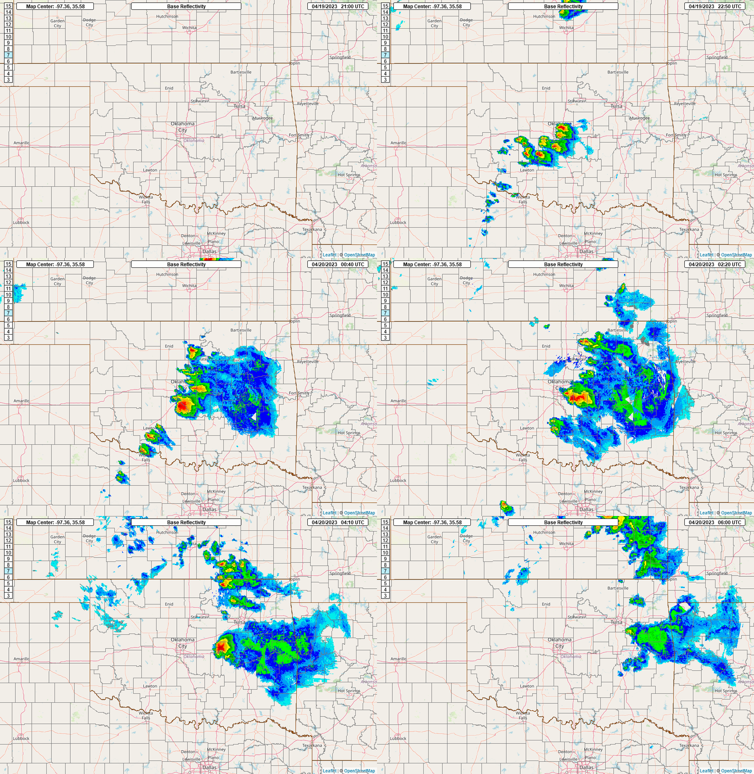
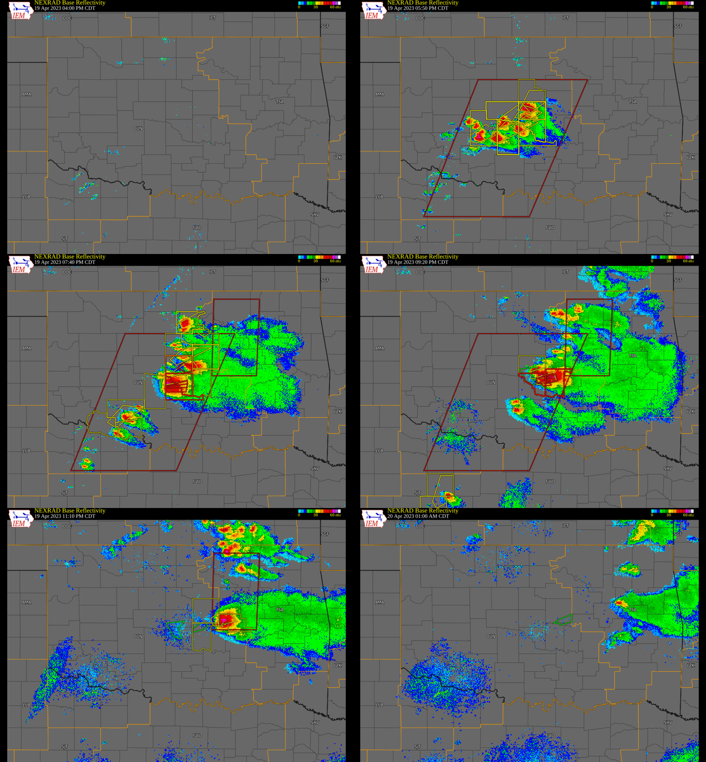
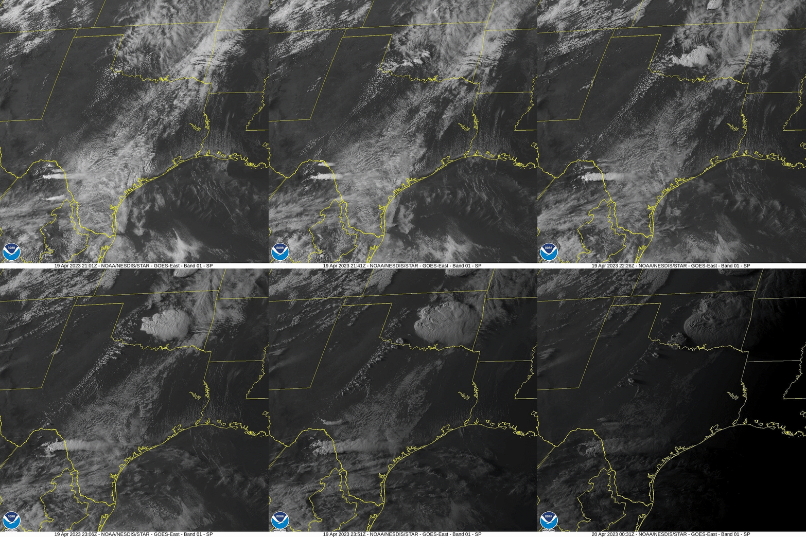
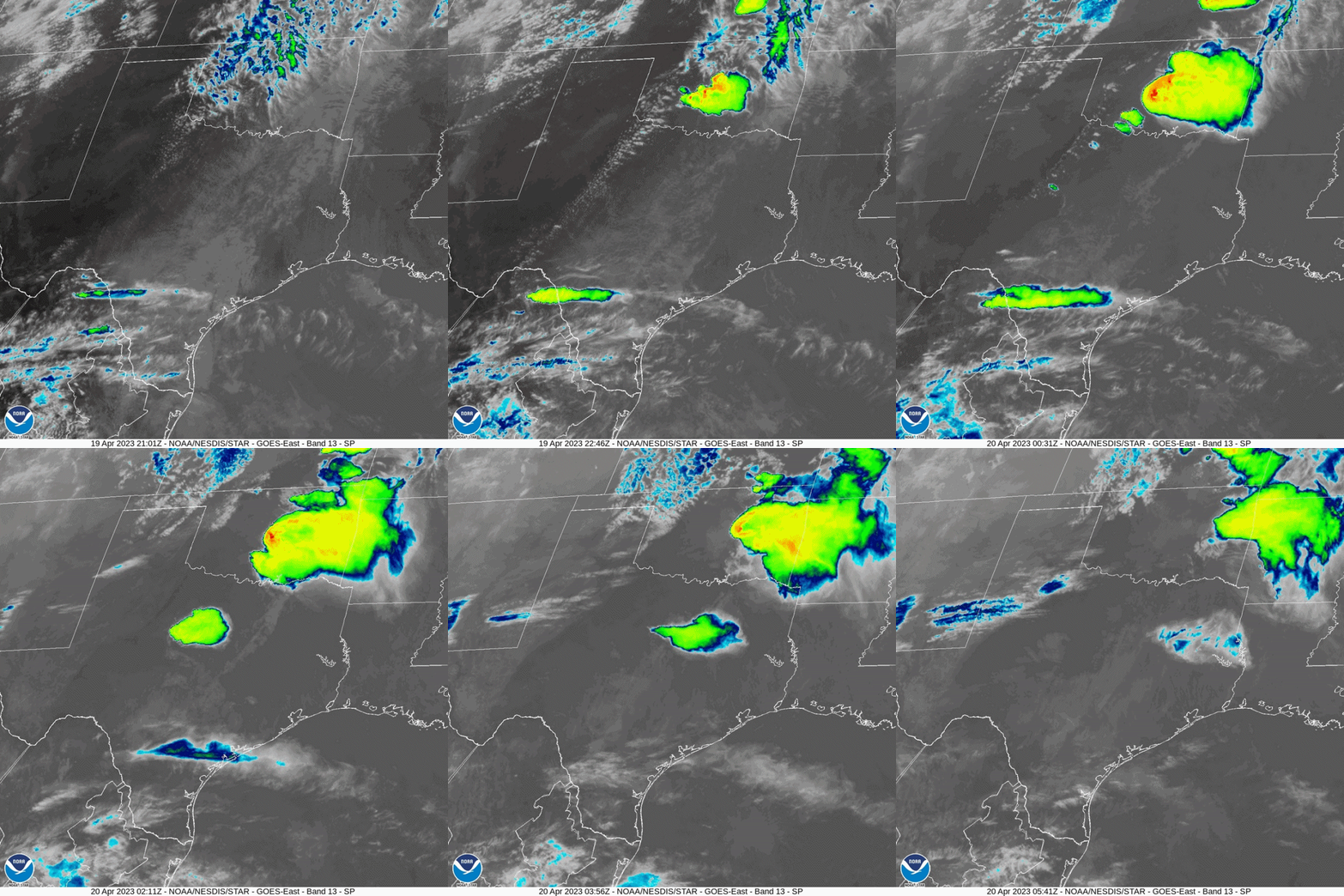
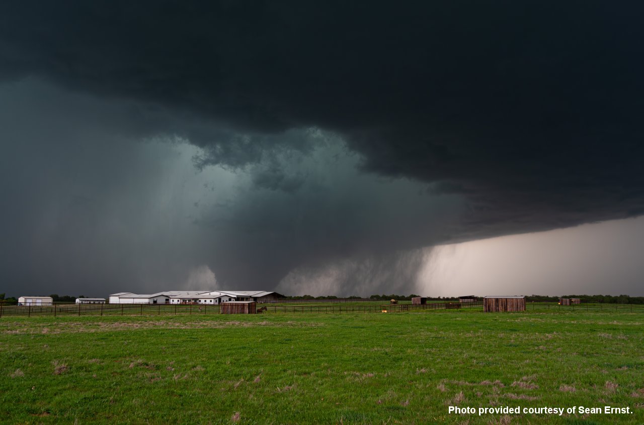 Photo 1: This photo is looking to the northwest near the intersection of OK State Highway 39 and Sante Fe Road about 8 miles west of Purcell, OK in McClain County. The photo shows the Cole-Goldsby EF-3 tornado as it was moving erratically to the northeast in the vicinity of Cole, OK. This photo was provided courtesy of Sean Ernst. |
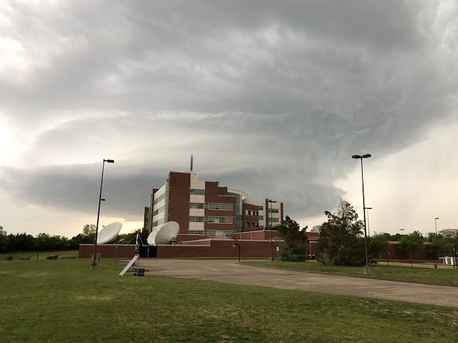 Photo 2: This photo is looking to the west at the National Weather Center and shows a supercell thunderstorm in the background as it was moving to the northeast across the western and northwestern parts of Norman, OK. This photo was taken by an NWS Norman forecaster during upper air balloon launch operations. |
This photo shows damage north of Pink was caused by the "Pink" tornado on April 19, 2023. A survey of the area was conducted on April 20, 2023.
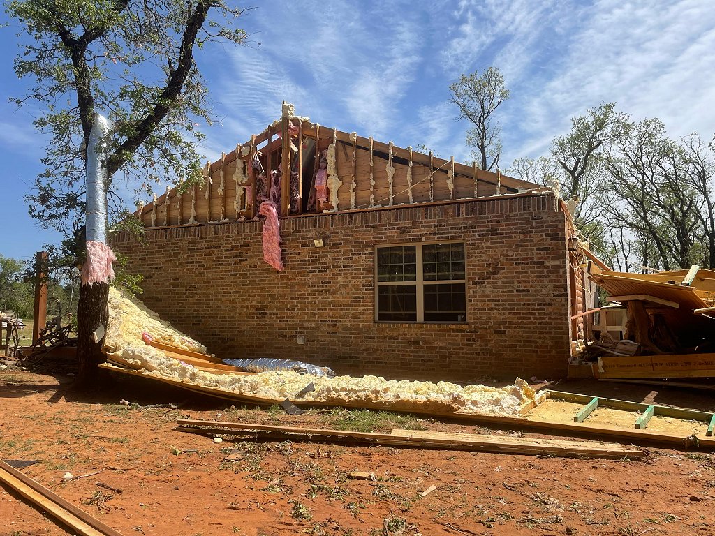 Photo 1: This photo shows damage to the roof and upper wall of a house north of Pink in northwestern Pottawatomie County. This damage was rated EF-2. |
These photos show damage at Oklahoma Baptist University caused by the "Shawnee" tornado on April 19, 2023. A survey of the area was conducted on April 20, 2023.
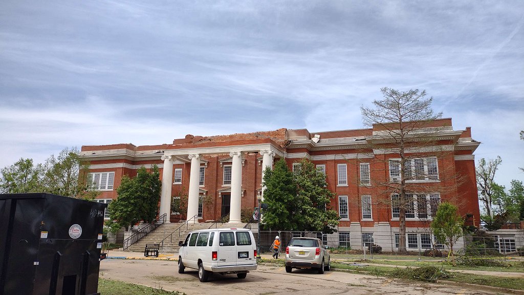 Photo 1: This photo shows damage to the roof of a building on the campus of Oklahoma Baptist University in Shawnee, OK in Pottawatomie County. Some of the pre-cast concrete roof slabs were uplifted. |
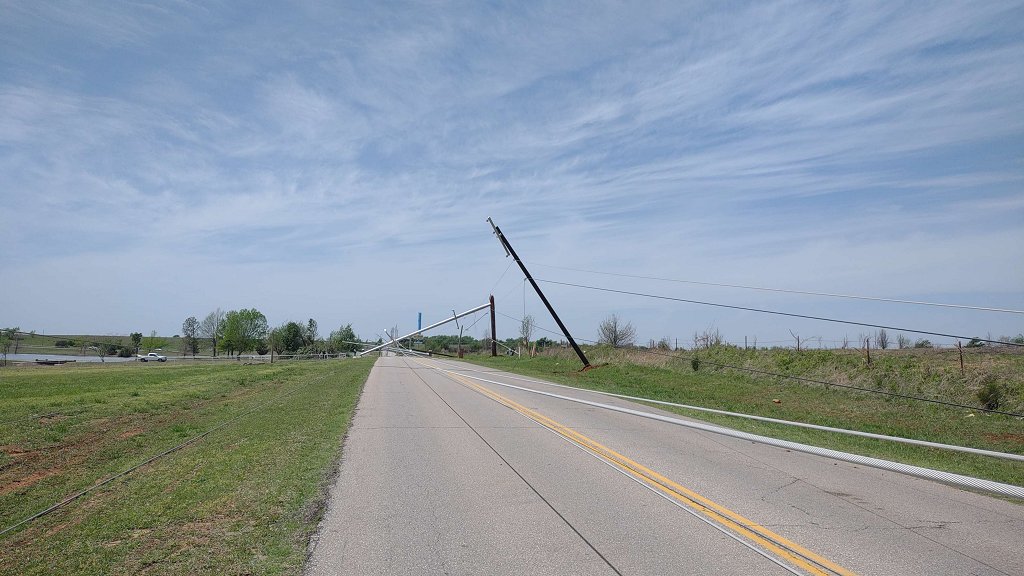 Photo 2: This photo shows damaged utility poles on West 45th Street on the north side of Shawnee, OK in Pottawatomie County. |
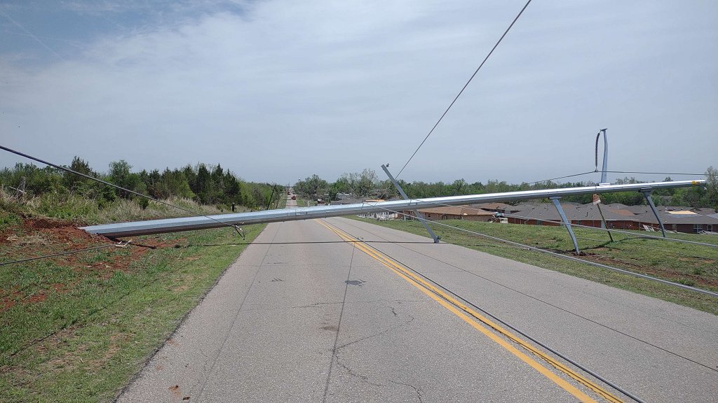 Photo 3: This photo shows damaged utility poles on West 45th Street on the north side of Shawnee, OK in Pottawatomie County. |