
Heat expands across the Desert Southwest, Plains, Mississippi Valley and Midwest into Monday. Fire weather concerns continue for portions of the Intermountain West. Active monsoonal moisture fuels thunderstorms over the Southwest with possible flash flooding. Tropical cyclone Fausto in the Pacific, should weaken as it approaches Hawaii; Dangerous surf, swells and rip currents are expected. Read More >
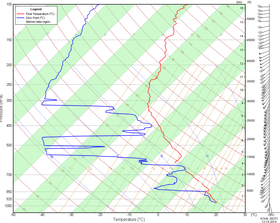
A strong upper level low moved over the Southern and Central Plains region during the day on Sunday, December 14, 2014. Adequate moistening and sunshine allowed for modest instability to build within a narrow corridor across central Oklahoma. Isolated thunderstorms developed along a Pacific front/dryline feature during the mid afternoon hours. These storms occasionally exhibited supercell characteristics, producing large hail and funnel clouds. One very brief tornado occurred over northeastern Oklahoma County near Arcadia Lake. No damage or injuries occurred.
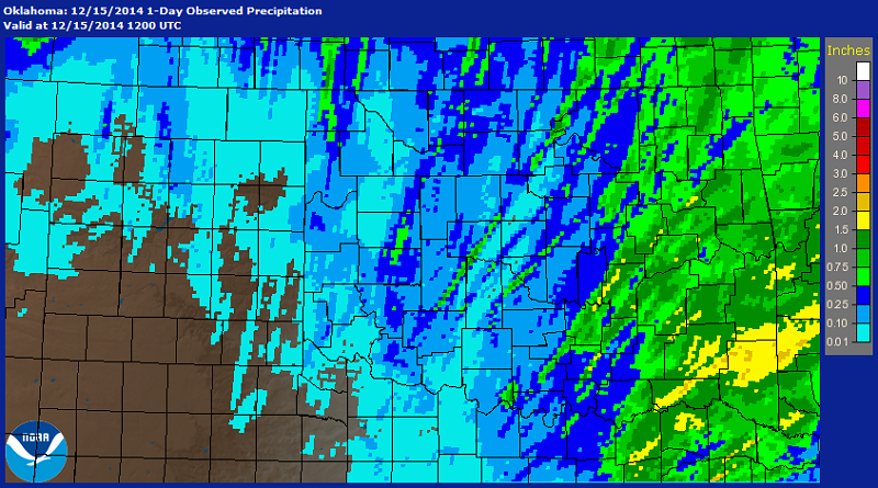
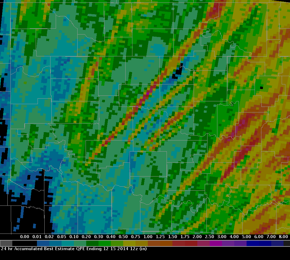
The following two graphics show the multi-sensor precipitation estimates (MPE) for the 24-hour period ending at 6 PM CST on December 15, 2014. Rainfall reports for the event generally ranged from about 0.25 to 1.50 inches in the NWS Norman forecast area. One interesting aspect of these rainfall maps is that tracks of individual thunderstorms can be identified where the heavier streaks of precipitation occur in the maps.
NWUS54 KOUN 150408
LSROUN

PRELIMINARY LOCAL STORM REPORT...SUMMARY
NATIONAL WEATHER SERVICE NORMAN OK
1007 PM CST SUN DEC 14 2014

..TIME...   ...EVENT...      ...CITY LOCATION...     ...LAT.LON...
..DATE...   ....MAG....      ..COUNTY LOCATION..ST.. ...SOURCE....
            ..REMARKS..

0347 PM     HAIL             CHICKASHA               35.04N 97.94W
12/14/2014  E1.25 INCH       GRADY              OK   TRAINED SPOTTER

0348 PM     HAIL             2 N CHICKASHA           35.07N 97.94W
12/14/2014  E1.25 INCH       GRADY              OK   STORM CHASER

0350 PM     HAIL             3 N CHICKASHA           35.09N 97.94W
12/14/2014  E2.00 INCH       GRADY              OK   TRAINED SPOTTER

0426 PM     HAIL             6 WSW OKLAHOMA CITY     35.43N 97.61W
12/14/2014  E1.00 INCH       OKLAHOMA           OK   BROADCAST MEDIA

0435 PM     HAIL             4 W OKLAHOMA CITY       35.47N 97.58W
12/14/2014  E1.50 INCH       OKLAHOMA           OK   TRAINED SPOTTER

            I-40/I-44 INTERCHANGE

0445 PM     HAIL             OKLAHOMA CITY           35.47N 97.51W
12/14/2014  E1.75 INCH       OKLAHOMA           OK   BROADCAST MEDIA

            DOWNTOWN OKC, PLAZA DISTRICT

0447 PM     HAIL             OKLAHOMA CITY           35.47N 97.51W
12/14/2014  E2.00 INCH       OKLAHOMA           OK   PUBLIC

            DOWNTOWN PLAZA DISTRICT, REPORT VIA SOCIAL MEDIA

0456 PM     HAIL             4 SE EDMOND             35.61N 97.43W
12/14/2014  E1.00 INCH       OKLAHOMA           OK   BROADCAST MEDIA

            COVERING GROUND AT I-35 AND KILPATRICK TURNPIKE
            INTERCHANGE

0502 PM     HAIL             5 SE EDMOND             35.60N 97.41W
12/14/2014  E1.75 INCH       OKLAHOMA           OK   NWS EMPLOYEE

            NEAR 122ND AND AIR DEPOT BLVD

0509 PM     TORNADO          4 SW ARCADIA            35.62N 97.38W
12/14/2014                   OKLAHOMA           OK   BROADCAST MEDIA

            KWTV VIDEO. LASTED LESS THAN A MINUTE. NO DAMAGE.

0600 PM     TSTM WND GST     CENTRAHOMA              34.61N 96.34W
12/14/2014  E65.00 MPH       COAL               OK   PUBLIC

            RELAYED BY KTEN TV.


&&

$$
|
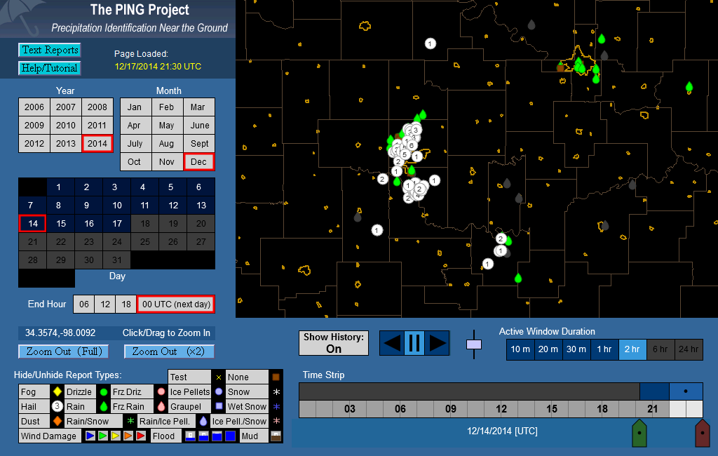
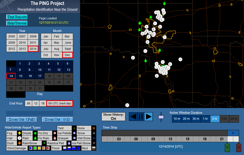
The following two graphics are screen captures showing 2-hour durations of hail and other weather reports across the NWS Norman forecast area and the OKC metro area from 4-6 PM CST on December 14, 2014. These reports came from various people using the mPING application on their mobile devices. The Meteorological Phenomena Identification Near the Ground (mPING) is a project designed to collect weather information from the public through their smart phone or mobile device with GPS location capabilities. For more information, please visit the mPING website at:
Note: the white circle depict hail size reports. The numeral on the circle is a code that corresponds to a specific hail size. "1" represents a hail size of 0.25"; "2" represents a hail size of 0.50"; "3" represents a hail size of 0.75"; etc.
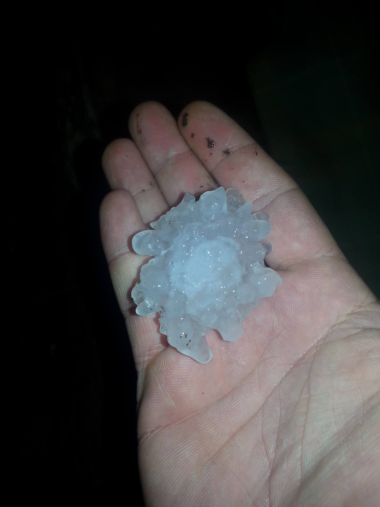
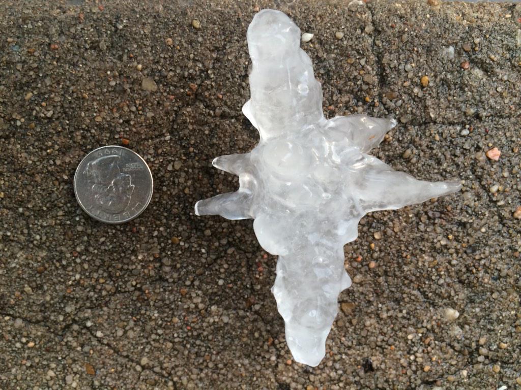 Hailstone in Dowtown OKC Photo courtesy Megan Jester |
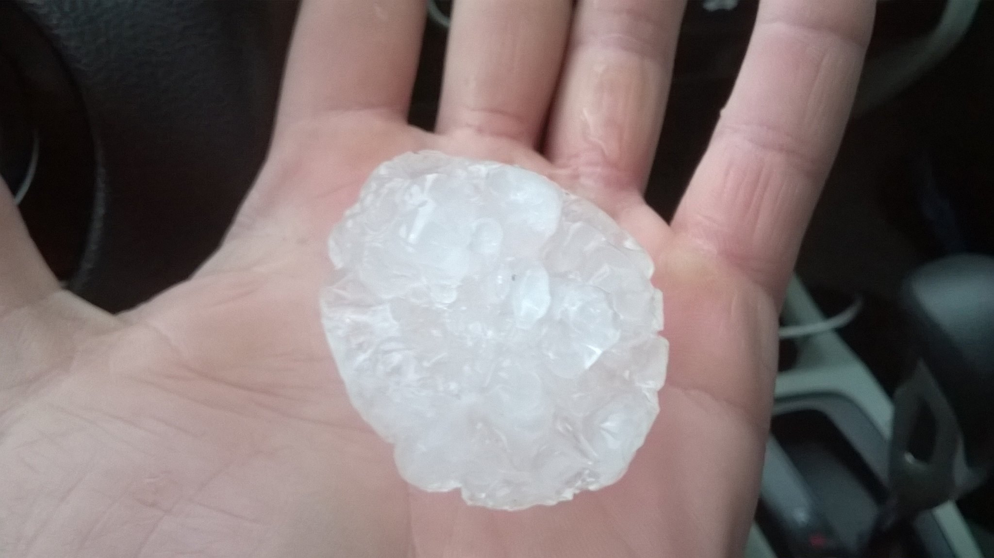 Photo courtesy Jason Collins |
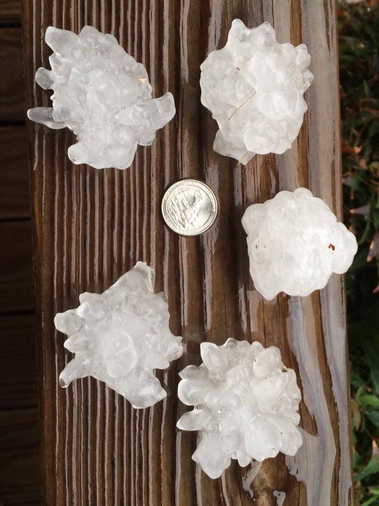 Hailstones in the OKC Plaza District Photo courtesy Dustin Akers |
 Hailtone near NW 10th & Penn in OKC Photo courtesy Curtis Schwab |


