
Heat expands across the Desert Southwest, Plains, Mississippi Valley and Midwest into Monday. Fire weather concerns continue for portions of the Intermountain West. Active monsoonal moisture fuels thunderstorms over the Southwest with possible flash flooding. Tropical cyclone Fausto in the Pacific, should weaken as it approaches Hawaii; Dangerous surf, swells and rip currents are expected. Read More >
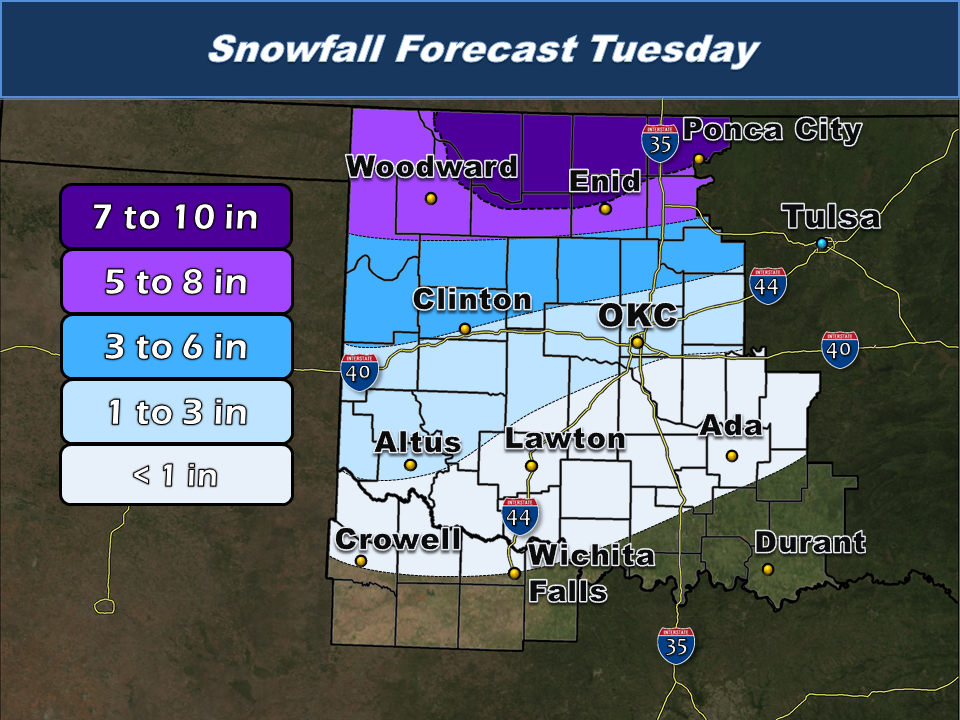
A strong upper level storm system followed quick on the heels of the February 2, 2014 winter storm, bringing snow to many parts of Oklahoma that missed out on the first round. With a deep cold airmass remaining in place, this event was mainly a snow event, but a pronounced warm nose (warm layer of air just above the surface) lead to some light freezing rain and sleet early on. Precipitation began late Monday night (2/3/2014) over the Texas and Oklahoma Panhandles and spread eastward as the upper low deepened, lifting north and east.
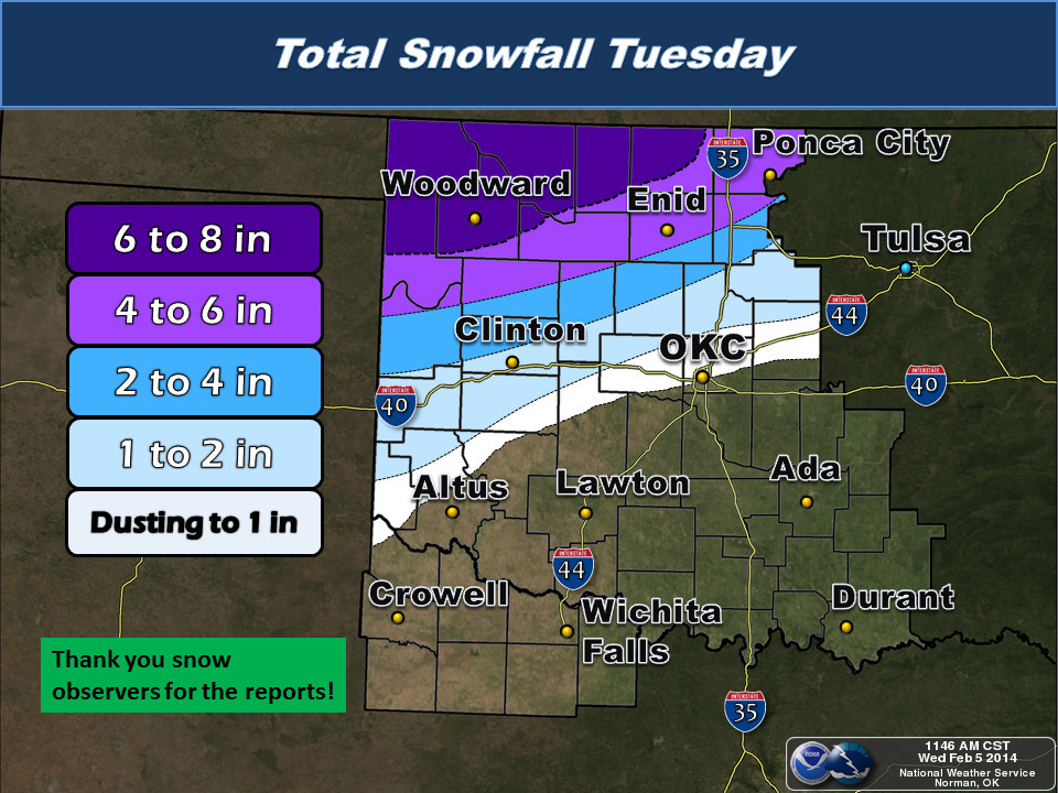
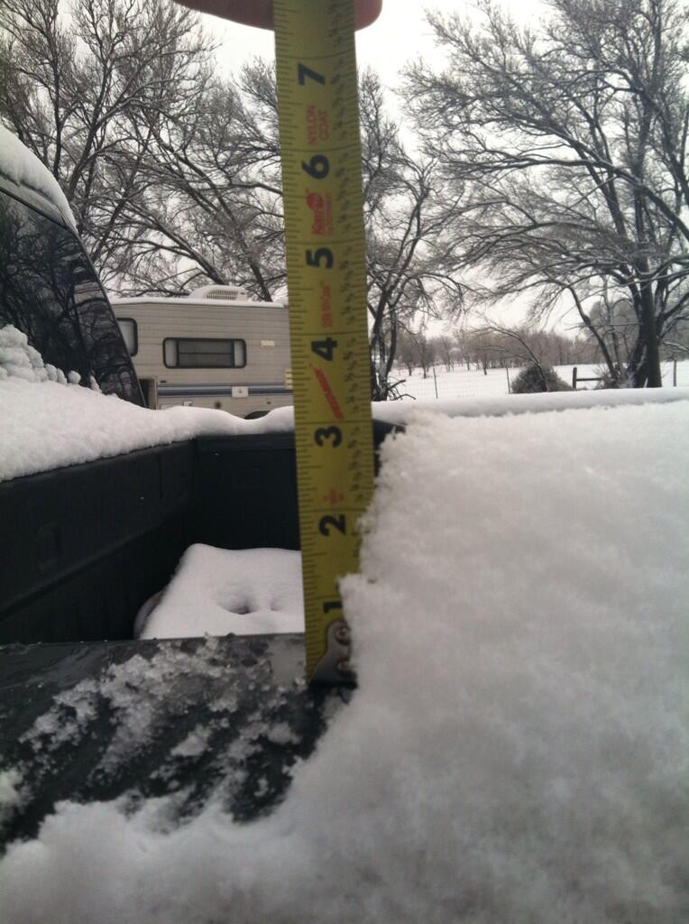
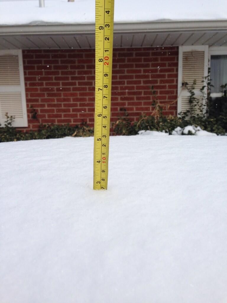
Heavy snow persisted overnight and into the day on Tuesday (2/4/2014), finally ending by late afternoon. Once all was said and done, areas along and north of the Kansas-Oklahoma border recorded the greatest snow amounts, with several places over nothern and western Oklahoma reporting up to 8 inches. Further south, less snow was reported with little to no snow accumulation along or south of U.S. Interstate Highway 40 (I-40). Once the storm system vacated the area, a bitterly cold airmass swept in, bringing record cold temperatures and wind chills well below zero to the region.
NWUS54 KOUN 042130
LSROUN

PRELIMINARY LOCAL STORM REPORT
NATIONAL WEATHER SERVICE NORMAN OK
330 PM CST TUE FEB 04 2014

..TIME...   ...EVENT...      ...CITY LOCATION...     ...LAT.LON...
..DATE...   ....MAG....      ..COUNTY LOCATION..ST.. ...SOURCE....
            ..REMARKS..

0130 PM     SNOW             CHEYENNE                35.61N 99.68W
02/04/2014  E3.0 INCH        ROGER MILLS        OK   FIRE DEPT/RESCUE

0130 PM     SNOW             REYDON                  35.65N 99.92W
02/04/2014  E5.0 INCH        ROGER MILLS        OK   FIRE DEPT/RESCUE

0143 PM     SNOW             CLINTON                 35.51N 98.97W
02/04/2014  E1.0 INCH        CUSTER             OK   FIRE DEPT/RESCUE

0150 PM     SNOW             6 NE MOOREWOOD          35.80N 99.28W
02/04/2014  E4.0 INCH        CUSTER             OK   PUBLIC

            SNOW DEPTH RANGED FROM 3 TO 4 INCHES

0150 PM     SNOW             WATONGA                 35.85N 98.41W
02/04/2014  E1.0 INCH        BLAINE             OK   FIRE DEPT/RESCUE

0152 PM     SNOW             COVINGTON               36.31N 97.59W
02/04/2014  E3.5 INCH        GARFIELD           OK   PUBLIC

0152 PM     SNOW             PONCA CITY              36.71N 97.09W
02/04/2014  E4.5 INCH        KAY                OK   EMERGENCY MNGR

0152 PM     SNOW             PERRY                   36.29N 97.29W
02/04/2014  M3.0 INCH        NOBLE              OK   NEWSPAPER

0152 PM     SNOW             STILLWATER              36.12N 97.06W
02/04/2014  E2.5 INCH        PAYNE              OK   EMERGENCY MNGR

0152 PM     SNOW             BRAMAN                  36.92N 97.33W
02/04/2014  M3.5 INCH        KAY                OK   PUBLIC

0157 PM     SNOW             SHATTUCK                36.27N 99.88W
02/04/2014  E6.0 INCH        ELLIS              OK   PUBLIC

0200 PM     SNOW             BLACKWELL               36.80N 97.28W
02/04/2014  E3.0 INCH        KAY                OK   AMATEUR RADIO

0205 PM     SNOW             GUTHRIE                 35.88N 97.43W
02/04/2014  E1.0 INCH        LOGAN              OK   PUBLIC

0205 PM     SNOW             GAGE                    36.32N 99.76W
02/04/2014  E8.0 INCH        ELLIS              OK   PUBLIC

            CITY OFFICIAL ESTIMATED 6 TO 8 INCHES

0210 PM     SNOW             ARNETT                  36.14N 99.77W
02/04/2014  E6.0 INCH        ELLIS              OK   FIRE DEPT/RESCUE

0211 PM     SNOW             CHESTER                 36.22N 98.92W
02/04/2014  E5.0 INCH        MAJOR              OK   PUBLIC

0213 PM     SNOW             FORT SUPPLY             36.57N 99.57W
02/04/2014  E7.0 INCH        WOODWARD           OK   TRAINED SPOTTER

0217 PM     SNOW             WOODWARD                36.43N 99.39W
02/04/2014  E8.0 INCH        WOODWARD           OK   TRAINED SPOTTER

0219 PM     SNOW             MUTUAL                  36.23N 99.17W
02/04/2014  E6.0 INCH        WOODWARD           OK   FIRE DEPT/RESCUE

0222 PM     SNOW             SEILING                 36.15N 98.92W
02/04/2014  E5.0 INCH        DEWEY              OK   LAW ENFORCEMENT

0224 PM     SNOW             14 NNE CAMP HOUSTON     37.01N 99.02W
02/04/2014  E8.0 INCH        COMANCHE           KS   PUBLIC

            SNOW STILL FALLING

0235 PM     SNOW             LONGDALE                36.13N 98.55W
02/04/2014  E5.0 INCH        BLAINE             OK   FIRE DEPT/RESCUE

0237 PM     SNOW             6 N WATONGA             35.94N 98.41W
02/04/2014  E4.0 INCH        BLAINE             OK   PUBLIC

            REPORTED FROM ROMAN NOSE STATE PARK.

0241 PM     SNOW             3 NNE LOYAL             36.01N 98.10W
02/04/2014  E3.0 INCH        KINGFISHER         OK   PUBLIC

0245 PM     SNOW             VICI                    36.15N 99.30W
02/04/2014  M6.0 INCH        DEWEY              OK   PUBLIC

0249 PM     SNOW             ALABASTER CAVERNS STATE 36.70N 99.15W
02/04/2014  E8.0 INCH        WOODWARD           OK   PARK/FOREST SRVC

0251 PM     SNOW             HENNESSEY               36.11N 97.90W
02/04/2014  E3.0 INCH        KINGFISHER         OK   PUBLIC

0257 PM     SNOW             AMES                    36.25N 98.19W
02/04/2014  E5.0 INCH        MAJOR              OK   PUBLIC

0303 PM     SNOW             LAVERNE                 36.71N 99.90W
02/04/2014  E7.0 INCH        HARPER             OK   LAW ENFORCEMENT

0317 PM     SNOW             CHEROKEE                36.75N 98.35W
02/04/2014  E7.0 INCH        ALFALFA            OK   LAW ENFORCEMENT

0317 PM     SNOW             WAKITA                  36.88N 97.92W
02/04/2014  E4.0 INCH        GRANT              OK   PUBLIC


&&

$$

JPIKE
Berlin, OK - Photo Courtesy of Randy |
Enid, OK - Photo Courtesy of Emily Madeline |
Hydro, OK - Photo Courtesy of Miranda Bailey |
Purcell, OK - Photo Courtesy of Purcell PD |
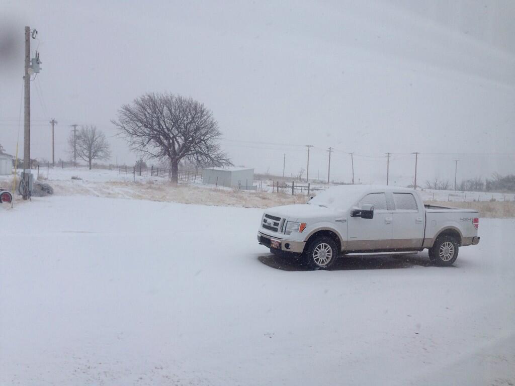
Vici, OK - Photo Courtesy of Kas Nelson |

Vici, OK - Photo Courtesy of Kas Nelson |
Winter Weather Briefing - February 2, 2014

