
Heat expands across the Desert Southwest, Plains, Mississippi Valley and Midwest into Monday. Fire weather concerns continue for portions of the Intermountain West. Active monsoonal moisture fuels thunderstorms over the Southwest with possible flash flooding. Tropical cyclone Fausto in the Pacific, should weaken as it approaches Hawaii; Dangerous surf, swells and rip currents are expected. Read More >
The combination of a very moist air mass, unstable air, fairly strong wind shear for late July, and a potent low pressure disturbance allowed for widespread showers and thunderstorms across much of Oklahoma and parts of western north Texas (see image below). Surface dew points were generally in the upper 60s to lower 70s. Precipitable water values were over 2 inches, above the 99th percentile for late July. The air was unstable with MLCAPE 1000-2500 J/kg. The low pressure disturbance helped to lift the moist unstable air.
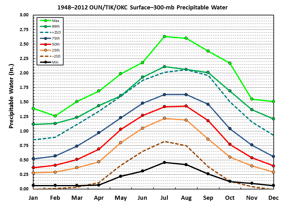 Climatology of Precipitable Water (PWAT) |
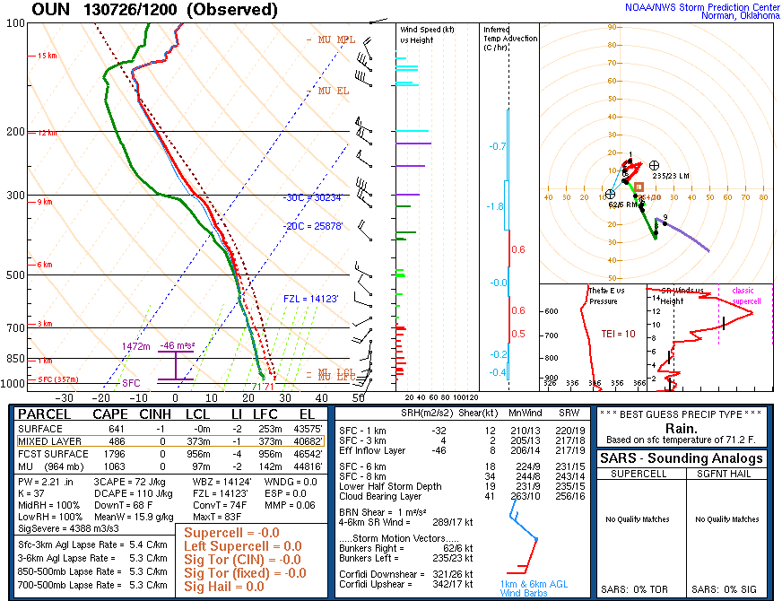 12Z (7am) Environmental Sounding |
The showers and storms moved southeast throughout the night, moving into deeper moisture. These showers and storms became very efficient at producing heavy rain. Rainfall rates were generally 1-3 inches per hour in the heaviest bands, though unusually high rates up to 9 inches per hour were observed. These rates overwhelmed drainage systems and small ditches and waterways, causing flash flooding with impassable roadways and numerous water rescues 3-9 am near the Oklahoma City metro and Lawton areas. A few severe thunderstorms occurred near Weatherford and Lawton, producing hail up to the size of golf balls and 60-65 mph winds.
NWUS54 KOUN 261353
LSROUN

PRELIMINARY LOCAL STORM REPORT
NATIONAL WEATHER SERVICE NORMAN OK
853 AM CDT FRI JUL 26 2013

..TIME...   ...EVENT...      ...CITY LOCATION...     ...LAT.LON...
..DATE...   ....MAG....      ..COUNTY LOCATION..ST.. ...SOURCE....
            ..REMARKS..

0550 AM     FLASH FLOOD      2 WSW VALLEY BROOK      35.39N 97.51W
07/26/2013                   OKLAHOMA           OK   BROADCAST MEDIA

            KWTV REPORTS I-240 AND SANTA FE FLOODED...WITH UP TO 1
            FOOT OF WATER COVERING ROADWAYS AND WATER UP TO CAR
            BUMPERS.

0620 AM     FLASH FLOOD      3 NE WILL ROGERS AIRPOR 35.44N 97.57W
07/26/2013                   OKLAHOMA           OK   BROADCAST MEDIA

            KOCO REPORTS SW 29TH AND MAY AVE FLOODED WITH 1 TO 2 FEET
            OF WATER WITH 4 TO 5 CARS FLOODED/STALLED.

0626 AM     FLASH FLOOD      LAWTON                  34.60N 98.42W
07/26/2013                   COMANCHE           OK   BROADCAST MEDIA

            KSWO 7 NEWS IN LAWTON REPORTED NUMEROUS
            ROADS/INTERSECTIONS CLOSED IN AND AROUND THE LAWTON/FT.
            SILL AREA DUE TO FLASH FLOODING.

0641 AM     FLASH FLOOD      2 SW OKLAHOMA CITY      35.44N 97.55W
07/26/2013                   OKLAHOMA           OK   STORM CHASER

            STORM CHASER/MEDIA PHOTOGRAPHER REPORTS INTERSECTION OF
            SW 20TH AND PENN FLOODED...UP TO 1 FOOT OF WATER.

0656 AM     FLASH FLOOD      3 W NORMAN              35.22N 97.50W
07/26/2013                   CLEVELAND          OK   PUBLIC

            PUBLIC REPORTS W MAIN ST CLOSED DUE TO FLASH FLOODING
            BETWEEN NW 36TH AND 48TH. NW 36TH CLOSED SOUTH OF W MAIN
            STREET DUE TO FLOODING...STALLED CARS.

0700 AM     FLASH FLOOD      1 SSW NORMAN            35.20N 97.45W
07/26/2013                   CLEVELAND          OK   BROADCAST MEDIA

            KWTV REPORTS INTERSECTION OF ELM AND LINDSEY FLOODED WITH
            1 TO 2 FEET OF WATER.

0700 AM     FLASH FLOOD      1 SSE NORMAN            35.21N 97.44W
07/26/2013                   CLEVELAND          OK   NWS EMPLOYEE

            NWS EMPLOYEE REPORTS THE INTERSECTION OF BOYD AND CLASSEN
            FLOODED WITH 1 TO 2 FEET OF WATER.

0700 AM     FLASH FLOOD      1 S NOBLE               35.12N 97.39W
07/26/2013                   CLEVELAND          OK   NWS EMPLOYEE

            NWS EMPLOYEE REPORTS WATER OVER HIGHWAY 77 IN SOUTH
            NOBLE.


&&

$$

JTK
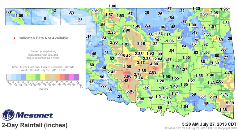
The following image from the Oklahoma Mesonet shows the total precipitation from 5 AM CDT July 25 to 5 AM CDT July 27. Much of the higher amounts fell in as little as 2 to 4 hours.


ASUS64 KOUN 270317
 RTPOK

 OKLAHOMA TEMPERATURE AND PRECIPITATION TABLE
 NATIONAL WEATHER SERVICE NORMAN OK
 732 PM CDT FRI JUL 26 2013

 VALUES REPRESENT 18 HOUR HIGH... 18 HOUR LOW
 AND PRECIPITATION OVER THE LAST 24 HOURS
 ENDING AT 7 PM CDT

 .BR OUN 0726 C DH19/TAIRZS/TAIRZI/PPDRZZ
 :
 :                                  HIGH   LOW   PCPN
 :
 :...WESTERN OKLAHOMA AND WESTERN NORTH TEXAS...
 LTS : ALTUS AFB                  :  88 /  72 /   .06
 CSM : CLINTON                    :  87 /  69 /  1.17
 FDR : FREDERICK                  :  88 /  72 /   .40
 GAG : GAGE                       :  89 /  67 / TRACE
 GUY : GUYMON                     :  88 /  64 /   .15
 HBR : HOBART                     :  87 /  70 /  2.04
 LAW : LAWTON/AIRPORT             :  87 /  71 /  4.44
 FSI : LAWTON/FORT SILL           :  86 /  72 /  5.58
 SPS : WICHITA FALLS              :  88 /  73 /   .35
 :
 :...NORTHERN AND CENTRAL OKLAHOMA...
 GOK : GUTHRIE                    :  86 /  72 /  1.08
 OKC : OKLAHOMA CITY/WILL ROGERS  :  85 /  71 /  3.55
 PWA : OKLAHOMA CITY/WILEY POST   :  83 /  69 /  2.67
 TIK : OKLAHOMA CITY/TINKER AFB   :  82 /  70 /  2.13
 PNC : PONCA CITY                 :  88 /  70 /   .22
 SWO : STILLWATER                 :  85 /  71 /  1.30
 :
 :...EASTERN OKLAHOMA...
 BVO : BARTLESVILLE               :  82 /  71 /  1.45
 MLC : MCALESTER                  :  79 /  71 /  1.54
 MKO : MUSKOGEE                   :  78 /  71 /   .42  ...PCPN ESTIMATED...
 TUL : TULSA/INTL AIRPORT         :  82 /  71 /   .81
 RVS : TULSA/JONES AIRPORT        :  83 /  73 /   .52
 .END

 THESE DATA ARE PRELIMINARY AND HAVE NOT UNDERGONE FINAL
 QUALITY CONTROL BY THE NATIONAL CLIMATIC DATA CENTER
 /NCDC/. THEREFORE THESE DATA ARE SUBJECT TO REVISION.
 FINAL AND CERTIFIED CLIMATE DATA CAN BE ACCESSED AT
 WWW.NCDC.NOAA.GOV.
 |
 |
 |
|
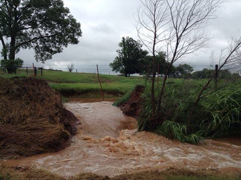
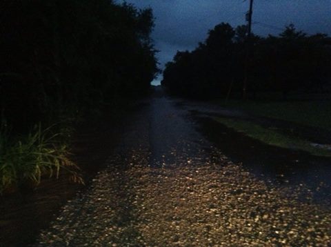
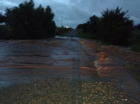
Images above from Grady County. Photos courtesy of Pattie Anderson |
||
 |
||
|
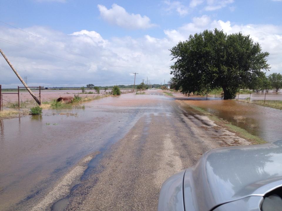
Image above from Cotton County. Photo courtesy of Bryan Goode |
||

