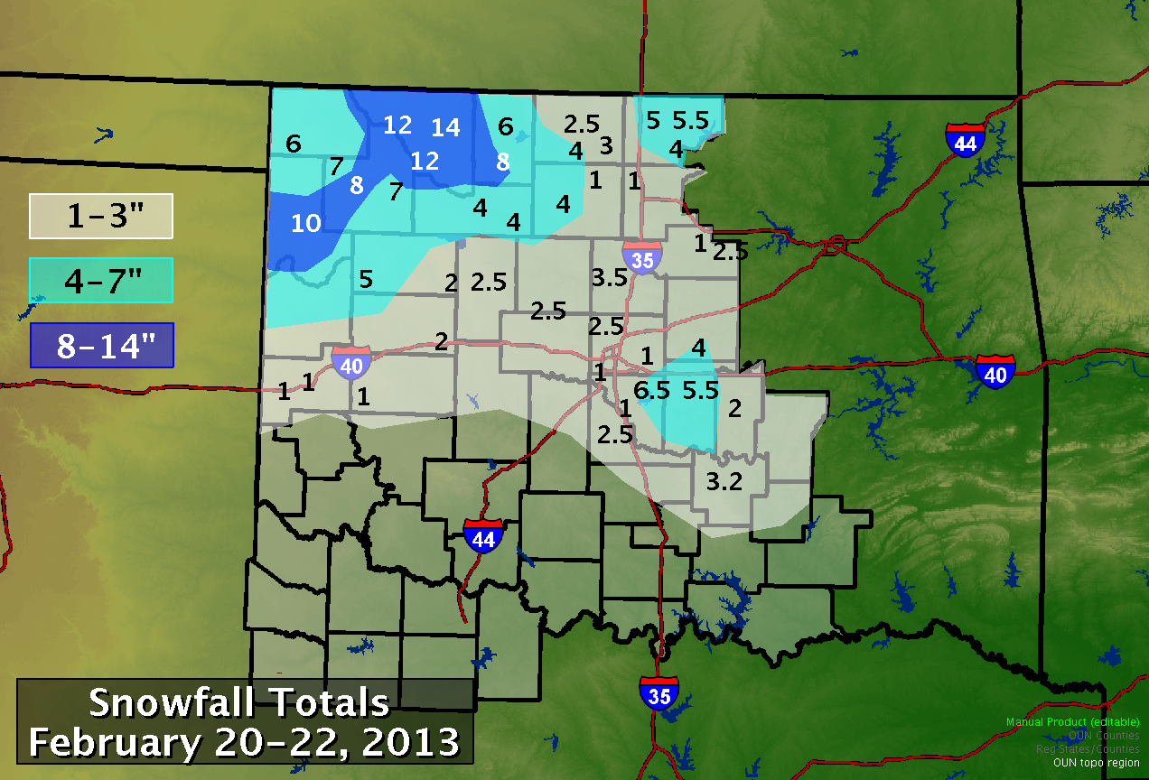
February 20-26, 2013 saw back to back winter storm systems move across Oklahoma and Western North Texas. The first wave moved into southwest Oklahoma and Western North Texas just after midnight on the 20th. This broad area of precipitation continued through the morning, moving off into Eastern Oklahoma by afternoon. A second round of storms moved in from the west late on the 20th, continuing into the morning hours of the 21st.
Temperatures hovered around freezing for most of the day allowing the precipitation type to fluctuate between rain, snow, and sleet. Northern Oklahoma received more of the snow, with accumulations in excess of ten inches in some locations. Southern Oklahoma and Western North Texas received mostly rain. Thundersnow and sleet also occurred with these storms.
Snowfall amounts tapered off from thirteen to fifteen inches near Alva to less than an inch around I-40. Liquid amounts were generally around an inch with localized areas receiving up to two inches.

PUBLIC INFORMATION STATEMENT
NATIONAL WEATHER SERVICE NORMAN OK
215 PM CST THU FEB 21 2013

SNOWFALL REPORT FOR WESTERN/CENTRAL OKLAHOMA AND WESTERN NORTH TEXAS
FROM COOPERATIVE OBSERVERS AND COCORAHS OBSERVERS FOR THE 48-HOUR
PERIOD ENDING AT 7 AM CST ON 2/21/2013

LOCATION                 SNOW
                         FALL

 --- NORTHWESTERN OKLAHOMA ---

ALVA 1W..................13.5
AMES..................... 4.0
AMES 4ESE................ 2.0
ARNETT 3NE...............10.0
FAIRVIEW 1N.............. 4.0
FORT SUPPLY 4SE.......... 7.1
FREEDOM.................. 9.0
LAVERNE 6S............... 6.0
LAHOMA RES. STN.......... 4.5
ORIENTA.................. 3.7
QUINLAN.................. 7.0
SHATTUCK 1SSW............ 5.3
WAYNOKA..................12.0
WOODWARD................. 7.9

 --- NORTH CENTRAL OKLAHOMA ---

BILLINGS................. 1.0
BILLINGS 4SSE............ 1.0
BLACKWELL................ 2.0
BRAMAN................... 5.2
ENID 1E.................. 2.3
ENID 4WNW................ 4.0
HARDY 2SSW............... 2.0
HUNTER 6NNE.............. 2.3
LAMONT................... 3.0
MEDFORD 1S............... 2.4
NEWKIRK.................. 5.5
NEWKIRK 5NE.............. 5.0
PONCA CITY 2NW........... 3.7

 --- WEST CENTRAL OKLAHOMA ---

ERICK.................... 0.9
FAY 2NE.................. 2.0
GEAR 10WNW............... 3.7
LEEDEY................... 5.0
MORAVIA 2NNE............. 0.5
RETROP................... 1.0
SAYRE.................... 1.0
SAYRE 1NE................ 1.0
WATONGA.................. 2.5
WEATHERFORD.............. 2.0

 --- CENTRAL OKLAHOMA ---

CHICKASHA 1E.............   T
CHOCTAW 1WSW............. 1.0
CRESCENT 5WSW............ 3.5
CUSHING.................. 0.8
EDMOND 2W................ 2.5
EDMOND 6NW............... 1.9
GLENCOE 2N............... 1.0
GLENCOE 3W............... 1.2
GUTHRIE 2S............... 1.0
MEEKER 5W................ 4.0
MOORE 1ENE............... 1.1
MOORE 1NE................ 1.3
NOBLE 2S................. 0.5
NORMAN 11ESE............. 1.0
NORMAN 8ESE.............. 1.1
NORMAN 8SE............... 0.9
NORMAN NWS OFFICE........ 0.4
OKARCHE...................2.4
OKLAHOMA CITY 6SW........ 0.8
PERKINS.................. 0.7
PURCELL 7W............... 2.5
STILLWATER 2W............ 0.7
YALE 1WNW................ 1.8

 --- SOUTHWESTERN OKLAHOMA ---

ANADARKO 3E..............   T
APACHE...................   T
WILLOW...................   T

 --- SOUTH CENTRAL OKLAHOMA ---

ADA...................... 3.2
ADA 4SE.................. 1.5
FILLMORE.1N..............   T
LEHIGH 4SW...............   T

"T" MEANS A TRACE AMOUNT OF SNOWFALL.

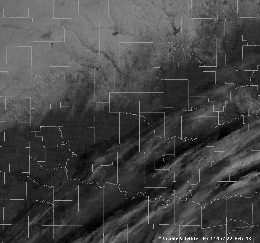
Local View of the Visible Satellite Image at 14:15 UTC on February 22, 2013

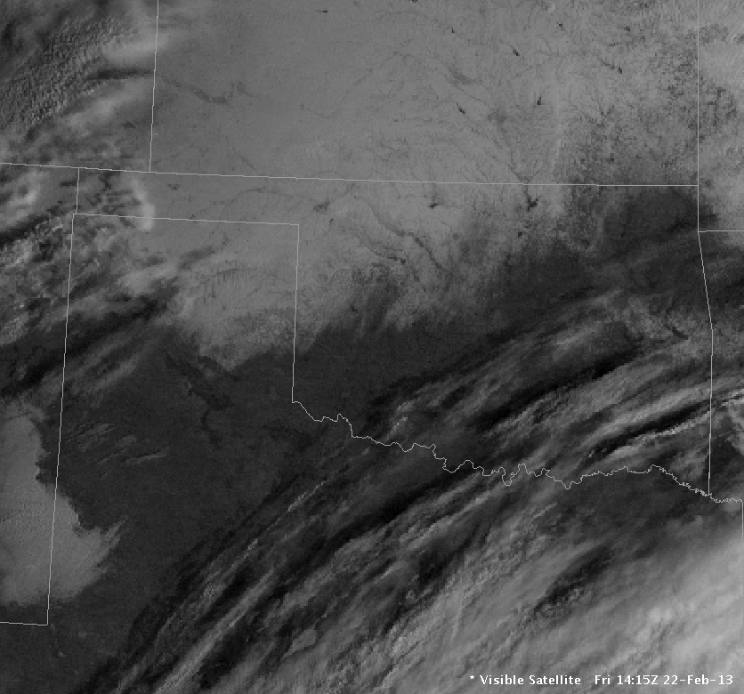
Regional View of the Visible Satellite Image at 14:15 UTC on February 22, 2013