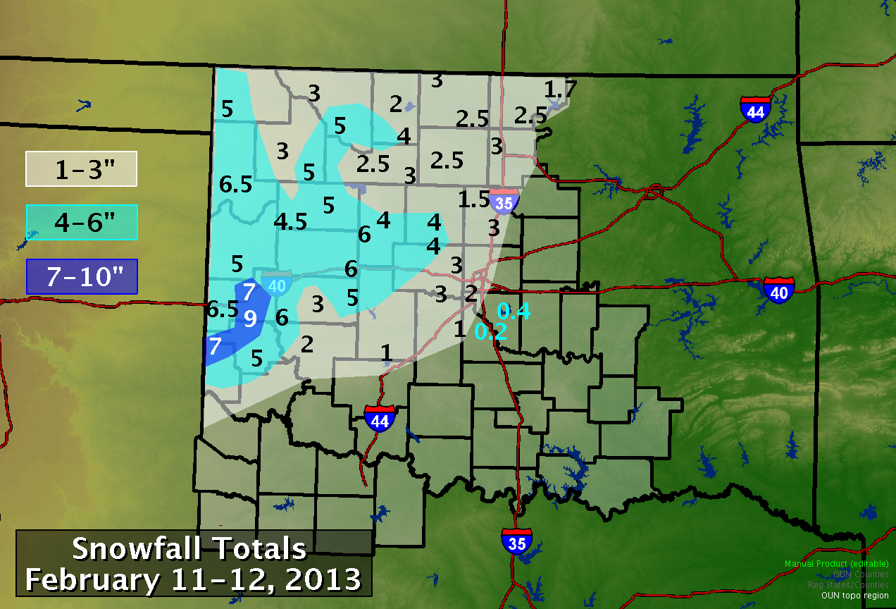
After a relatively warm and dry January throughout the southern Plains, the first significant winter storm of 2013 affected the area beginning the evening of February 11. As a large upper-level storm system moved east out of the Rockies, precipitation developed over west Texas, expanding into parts of western Oklahoma overnight. By sunrise on Tuesday, February 12, moderate to heavy snow was falling roughly north and west of a line from Hollis to Clinton to Watonga, with widespread rain to the east. The rain-snow line progressed southeastward through the morning, with most areas north of I-44 in Oklahoma reporting snow by noon. Precipitation gradually tapered off from west to east during the afternoon and early evening.
The airmass in place for this winter storm was not particularly cold, and surface temperatures hovered near or just above freezing in most areas during the snowfall. This resulted in a heavy, wet snow. For many areas in central Oklahoma, including the Oklahoma City metropolitan area, roads remained wet and accumulations were mainly confined to grassy areas. In parts of west-central and northwest Oklahoma, temperatures right at freezing combined with very heavy snowfall rates for a few hours in the morning to allow for significant accumulations on all surfaces.
Snowfall totals were 1" or greater across most of northern and western Oklahoma, as well as parts of central Oklahoma northwest of I-44. Amounts greater than 4" occurred across parts of western Oklahoma, with the highest totals occurring near the Texas border west of Elk City and Mangum.

PUBLIC INFORMATION STATEMENT
NATIONAL WEATHER SERVICE NORMAN OK
1045 PM CST THU FEB 14 2013
SNOWFALL REPORT FOR WESTERN/CENTRAL OKLAHOMA FROM COOPERATIVE
OBSERVERS AND COCORAHS OBSERVERS FOR THE 48-HOUR PERIOD ENDING AT
7 AM CST ON 2/13/2013
--NORTHWESTERN OKLAHOMA--
ELLIS COUNTY...
ARNETT 3NE 6.5
SHATTUCK 1SSW 5.1
HARPER COUNTY...
LAVERNE 1S 5.0
MAJOR COUNTY...
AMES 3.0
FAIRVIEW 1N 2.5
LAHOMA 1W 3.0
ORIENTA 2.5
WOODS COUNTY...
ALVA 1W 3.0
FREEDOM 3.0
WAYNOKA 5.0
WOODWARD COUNTY...
FORT SUPPLY 4SE 2.0
MUTUAL 4.0
QUINLAN 2.0
WOODWARD 1NE 3.2
--NORTH CENTRAL OKLAHOMA--
ALFALFA COUNTY...
CHEROKEE 4W 1.7
HELENA 1SSE 4.3
GARFIELD COUNTY...
ENID 1E 1.0
ENID 2ENE 2.5
ENID 4WNW 2.0
GRANT COUNTY...
HUNTER 6NNE 2.3
JEFFERSON 1.0
LAMONT 2.4
MEDFORD 0.9
KAY COUNTY...
BLACKWELL 2.0
BRAMAN 2.6
HARDY 2SSW 1.7
NEWKIRK 1.0
NEWKIRK 1NW 1.4
PONCA CITY 2NW 1.2
NOBLE COUNTY...
BILLINGS 4.0
BILLINGS 4SSE 3.0
--WEST CENTRAL OKLAHOMA--
BECKHAM COUNTY...
ERICK 6.6
MORAVIA 2NNE 3.0
RETROP 5.9
SAYRE 6.0
SAYRE 1NE 6.0
SAYRE 6N 5.0
SAYRE 8S 9.0
WILLOW 7N 3.0
BLAINE COUNTY...
FAY 2NE 6.0
GEARY 10WNW 3.2
WATONGA 1N 4.0
CUSTER COUNTY...
WEATHERFORD 6.0
DEWEY COUNTY...
LEEDEY 4.0
TALOGA 5.0
WASHITA COUNTY...
COLONY 5.0
--CENTRAL OKLAHOMA--
CANADIAN COUNTY...
MUSTANG 2WNW 1.0
UNION CITY 3SE 3.0
CLEVELAND COUNTY...
NOBLE 0.2
NORMAN 3SSE 0.2
STELLA 3S 0.4
KINGFISHER COUNTY...
KINGFISHER 4.0
LOGAN COUNTY...
CRESCENT 5WSW 3.0
EDMOND 2W 2.0
EDMOND 6NW 1.2
GUTHRIE 2S 2.0
GUTHRIE 3N 1.5
GUTHRIE 4NNW 0.5
MARSHALL 1.5
MCCLAIN COUNTY...
BLANCHARD 2SSW 1.0
PURCELL 7W T
OKLAHOMA COUNTY...
BETHANY 1SSW 1.5
EDMOND 2W 2.0
JONES 5N 0.5
WILL ROGERS AP 2.0
PAYNE COUNTY...
GLENCOE 2N 0.5
GLENCOE 3W 0.2
YALE 1WNW T
--SOUTHWESTERN OKLAHOMA--
CADDO COUNTY...
APACHE 1.0
ANADARKO 3E T
GREER COUNTY...
MANGUM 5.0
MANGUM 1ESE 2.6
WILLOW 5.0
HARMON COUNTY...
VINSON 6NW 7.0
* "T" means a trace of snowfall.