
Heat expands across the Desert Southwest, Plains, Mississippi Valley and Midwest into Monday. Fire weather concerns continue for portions of the Intermountain West. Active monsoonal moisture fuels thunderstorms over the Southwest with possible flash flooding. Tropical cyclone Fausto in the Pacific, should weaken as it approaches Hawaii; Dangerous surf, swells and rip currents are expected. Read More >
A strong cold front plowed through Oklahoma and north Texas on the February 10, 2012, dropping temperatures across the region into the teens and twenties. The frigid temperatures continued into the February 11th, as most areas did not make it above freezing on that day. Very dry air also followed the front, with surface dew point temperatures in the single digits. The several hours of below freezing temperatures allowed the ground temperatures to fall rapidly as well.
A transient storm system approached from the central Rocky Mountains, as south winds brought slightly warmer temperatures north into parts of Oklahoma. The temperatures warmed above freezing over parts of central and southern Oklahoma, as well as adjacent areas of north Texas, but remained in the 20s elsewhere.
Snowfall began over the Texas and Oklahoma panhandles, and quickly spread east into western Oklahoma. Saturation of the drier air occurred quickly near the Texas panhandle border. A band of moderate to heavy snow set up shop over parts of western Oklahoma, with snowfall rates approaching 1"/hour. This band did not move much during the first several hours, resulting in a quick 3 to 4 inches of snow to accumulate. But the area of snowfall was on the move, with any one area receiving light to moderate snowfall for about 3 to 4 hours.
|
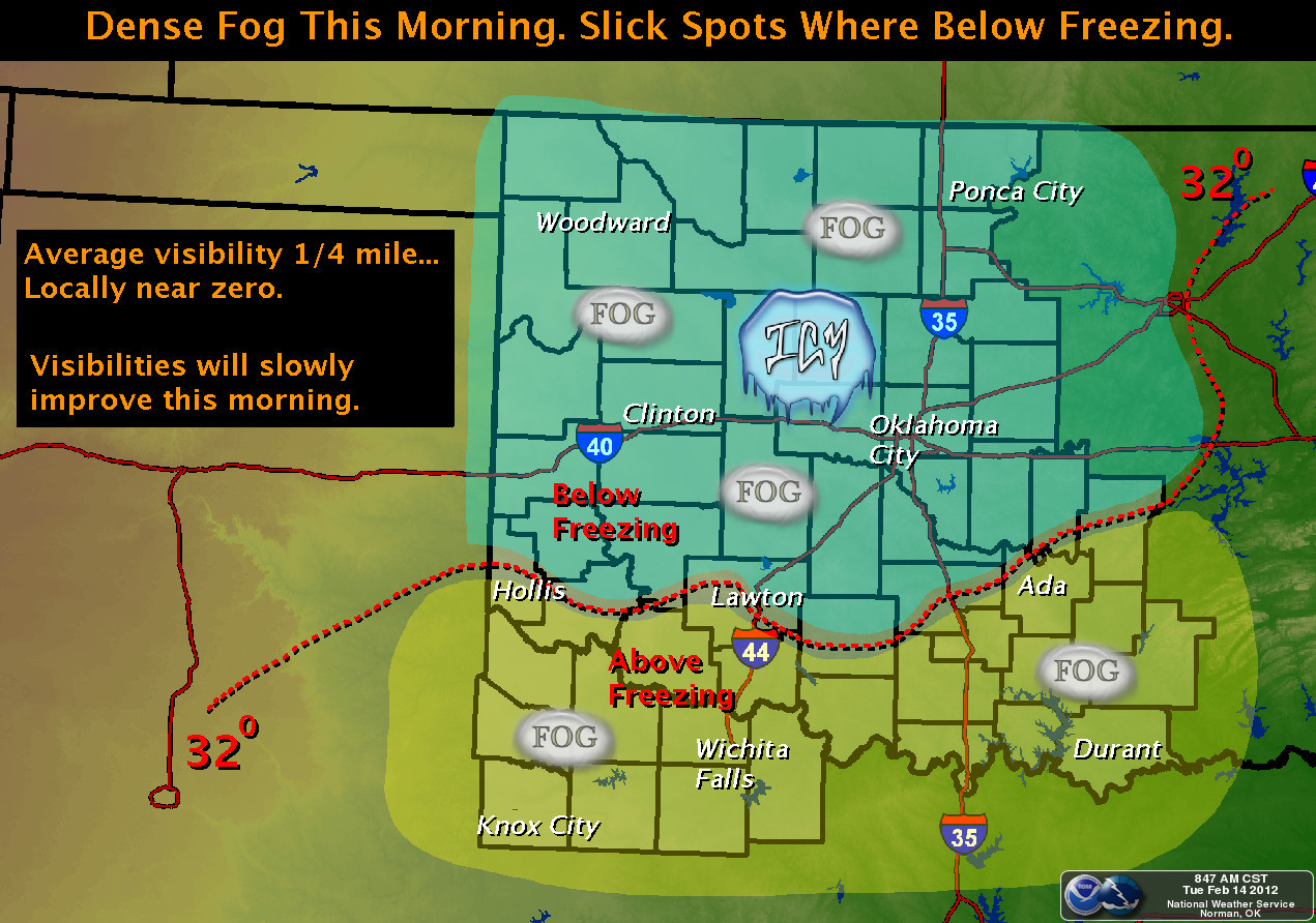
The isolated areas of higher snowfall totals over west-central Oklahoma were not the norm, as a wide a larger area of 2 to 3 inches of accumulation was more representative. Timing of this event was almost ideal for areas of central Oklahoma. Whereas the snowfall occurred earlier in the day over western Oklahoma, resulting in several more accidents, the snowfall occurred during the mid to late evening hours over central Oklahoma. Automobile traffic was at a minimum during this period, which resulted in few accidents. Numerous accidents occurred on area roadways during the event. The event may have occurred at an ideal time, however. Had this occurred during the work week, this may have had a higher impact. What may have been worse was the freezing fog that occurred a day after the snow ended. As mentioned earlier, south winds were present during the entire snowfall event. The south winds brought relatively warm air over Oklahoma, which melted much of the snow. The skies cleared, the winds calmed, and abundant moisture near the surface resulted in widespread dense fog. What made matters much worse was the fact the the temperatures fell below freezing resulting in freezing fog. The freezing fog deposited a thin layer of ice on the roadways and elevated surfaces. The morning rush hour was treacherous, with many automobile accidents reported. Luckily no serious injuries occurred. To read more about the formation of "radiation fog" you can click on the description provided by the Oklahoma Mesonet. |
 |
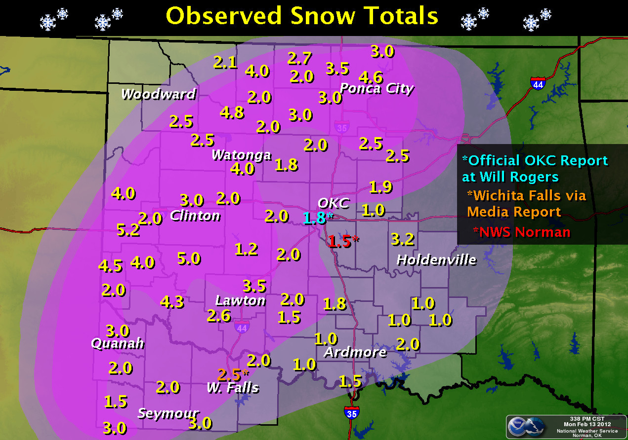
Here is the summary of the snow reports that we received at our office from this event.
NWUS54 KOUN 130911
LSROUN

PRELIMINARY LOCAL STORM REPORT...SUMMARY
NATIONAL WEATHER SERVICE NORMAN OK
310 AM CST MON FEB 13 2012

..TIME...   ...EVENT...      ...CITY LOCATION...     ...LAT.LON...
..DATE...   ....MAG....      ..COUNTY LOCATION..ST.. ...SOURCE....
            ..REMARKS..

0526 PM     SNOW             8 S REYDON              35.53N 99.92W
02/12/2012  E3.0 INCH        ROGER MILLS        OK   PUBLIC

0540 PM     SNOW             ERICK                   35.21N 99.87W
02/12/2012  E1.5 INCH        BECKHAM            OK   CO-OP OBSERVER

0615 PM     SNOW             ELK CITY                35.40N 99.41W
02/12/2012  E2.0 INCH        BECKHAM            OK   BROADCAST MEDIA

            THE REPORT WAS RELAYED VIA TWITTER

0730 PM     SNOW             HOLLIS                  34.69N 99.92W
02/12/2012  E2.0 INCH        HARMON             OK   LAW ENFORCEMENT

0800 PM     SNOW             HELENA                  36.55N 98.27W
02/12/2012  E2.0 INCH        ALFALFA            OK   PUBLIC

0800 PM     SNOW             ALTUS                   34.64N 99.33W
02/12/2012  M2.1 INCH        JACKSON            OK   BROADCAST MEDIA

0815 PM     SNOW             HOBART                  35.03N 99.09W
02/12/2012  M2.0 INCH        KIOWA              OK   PUBLIC

0845 PM     SNOW             6 SW CHEYENNE           35.55N 99.75W
02/12/2012  E4.0 INCH        ROGER MILLS        OK   PUBLIC

            UPDATED FROM PREVIOUS REPORT.

0915 PM     SNOW             ENID                    36.40N 97.88W
02/12/2012  M1.4 INCH        GARFIELD           OK   EMERGENCY MNGR

            AREA ROADWAYS ARE VERY SLICK... WITH SEVERAL ACCIDENTS
            REPORTED.

0930 PM     SNOW             QUANAH                  34.30N 99.74W
02/12/2012  M3.0 INCH        HARDEMAN           TX   LAW ENFORCEMENT

            UPDATE FROM PREVIOUS 2 INCH REPORT.

0930 PM     SNOW             BENJAMIN                33.58N 99.79W
02/12/2012  E1.5 INCH        KNOX               TX   LAW ENFORCEMENT

0930 PM     SNOW             KNOX CITY               33.42N 99.82W
02/12/2012  E3.0 INCH        KNOX               TX   LAW ENFORCEMENT

1000 PM     SNOW             4 N WICHITA FALLS       33.97N 98.50W
02/12/2012  E2.0 INCH        WICHITA            TX   PUBLIC

            THE SNOWFALL REPORT WAS RELAYED VIA TWITTER.

1020 PM     SNOW             SEILING                 36.15N 98.92W
02/12/2012  E2.5 INCH        DEWEY              OK   TRAINED SPOTTER

1030 PM     SNOW             CORDELL                 35.30N 98.98W
02/12/2012  E4.0 INCH        WASHITA            OK   PUBLIC

            THE SNOW REPORT WAS RELAYED VIA TWITTER.

1030 PM     SNOW             CLINTON                 35.51N 98.97W
02/12/2012  E3.0 INCH        CUSTER             OK   DEPT OF HIGHWAYS

            UPDATE FROM PREVIOUS 1 INCH REPORT. ODOT IS REPORTING
            SNOW COVERING I-40 BETWEEN CLINTON AND FOSS.

1125 PM     SNOW             WICHITA FALLS           33.91N 98.50W
02/12/2012  E2.5 INCH        WICHITA            TX   BROADCAST MEDIA

            UPDATE FROM PREVIOUS 1 INCH REPORT. THE SNOW REPORT WAS
            RELAYED BY KAUZ-TV.

1150 PM     SNOW             WILL ROGERS AIRPORT     35.39N 97.60W
02/12/2012  M0.9 INCH        OKLAHOMA           OK   OFFICIAL NWS OBS

1150 PM     SNOW             NORMAN                  35.22N 97.44W
02/12/2012  M1.1 INCH        CLEVELAND          OK   OFFICIAL NWS OBS

            MEASURED AT NATIONAL WEATHER CENTER

1200 AM     SNOW             N OKARCHE               35.73N 97.98W
02/13/2012  M1.8 INCH        KINGFISHER         OK   TRAINED SPOTTER

1200 AM     SNOW             PONCA CITY              36.71N 97.09W
02/13/2012  E1.5 INCH        KAY                OK   TRAINED SPOTTER

0100 AM     SNOW             2 SE NORMAN             35.20N 97.42W
02/13/2012  M1.7 INCH        CLEVELAND          OK   PUBLIC

            MEASURED NEAR HWY 9/77 INTERCHANGE

0110 AM     SNOW             NORMAN                  35.22N 97.44W
02/13/2012  M1.6 INCH        CLEVELAND          OK   TRAINED SPOTTER

            AT 12TH AND LINDSEY

0115 AM     SNOW             ELGIN                   34.78N 98.29W
02/13/2012  M3.5 INCH        COMANCHE           OK   PUBLIC

0130 AM     SNOW             DUNCAN                  34.52N 97.97W
02/13/2012  E3.0 INCH        STEPHENS           OK   AMATEUR RADIO

0130 AM     SNOW             ELMORE CITY             34.62N 97.40W
02/13/2012  M1.8 INCH        GARVIN             OK   PUBLIC

0140 AM     SNOW             2 W ENID                36.40N 97.91W
02/13/2012  E3.0 INCH        GARFIELD           OK   PUBLIC

0200 AM     SNOW             NORMAN                  35.22N 97.44W
02/13/2012  M2.4 INCH        CLEVELAND          OK   PUBLIC

            WEST 48TH AND MAIN ST


&&

$$

BURKE
|

