Extremely critical fire weather concerns for portions of the southern High Plans as strong wind and very dry conditions could result in rapid spread of any fires. Meanwhile, severe thunderstorms are expected once again across areas of the Central and Southern Plains, then spreading in the Mississippi Valley regions on Monday. Damaging winds, very large hail and strong tornadoes are possible. Read More >
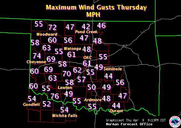
Numerous wildfires ravaged central and southern Oklahoma and parts of western North Texas, beginning in the morning on Thursday, April 9th, 2009, and continuing through the mid morning hours on Friday, April 10, 2009. The first wildfire was reported to the Norman Forecast Office between 10:00 AM and 11:00 AM, leading up to the rapid occurrence of wildfires by 3:00 PM. A dryline that became better defined around midday in central Oklahoma moved east through the afternoon, creating very low relative humidity which aided in the development and intensity of the fires. The key factor that magnified this event was extremely strong wind gusts across western and eventually central Oklahoma. A Pacific cold front followed a few hours after the dryline, and brought westerly winds sustained at 40 mph with gusts of 60 to 70 mph. A second cold front arrived in the mid to late evening, turning winds to the northwest and bringing cooler, continental air into the region. A graphic of the maximum observed wind gusts is included below. The strongest wind gust, 76 mph, was recorded 3 miles southeast of Frederick in Tillman County, Oklahoma, at 2:25 PM.
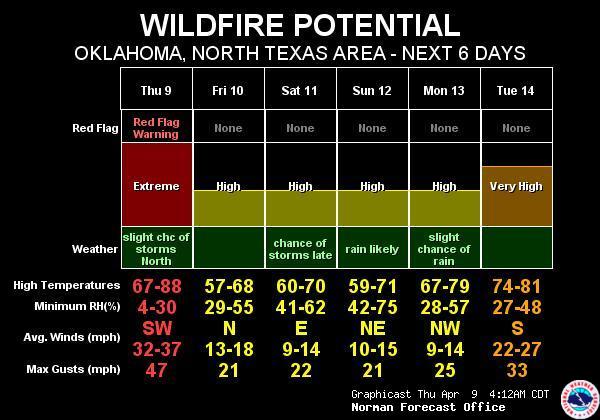
The National Weather Service (NWS) in Norman began advertising the elevated fire potential with a Fire Weather Watch, issued Tuesday evening, nearly 48 hours prior to the event. On Wednesday, the NWS upgraded the Fire Weather Watch to a Red Flag Warning from western north Texas up through southern and central Oklahoma, including the Oklahoma City metropolitan area. The Red Flag Warning was then extended farther north and east before sunrise Thursday morning. The Red Flag Warning update issued at 3:58 AM on Thursday April 9th, stated that:
     "TEMPERATURES IN THE 70S AND 80S AND RELATIVE HUMIDITIES
     BETWEEN 5 AND 20 PERCENT AND STRONG WESTERLY WINDS
     WILL CREATE CONDITIONS THAT WILL MAKE ANY WILDFIRES
     EXTREMELY DIFFICULT TO CONTAIN."
A Wind Advisory was also in effect for the same area as the Red Flag Warning. Issued Wednesday evening, the Wind Advisory stated that:
     "IT IS POSSIBLE THAT THE AREA FROM LAWTON UP TO WATONGA...
     AND OVER TO SHATTUCK...CHEYENNE...AND ELK CITY...MAY
     EXPERIENCE A ONE TO TWO HOUR PERIOD OF DAMAGING WIND
     GUSTS AROUND 60 MPH THURSDAY AFTERNOON.  THIS AREA WILL
     BE MONITORED FOR A POSSIBLE  UPGRADE TO A HIGH WIND
     WARNING."
This forecast, along with an accompanying web-based graphic, gave a heads up to the potential for excessive wind gusts with this storm system. In reality, the high winds lasted longer and affected a larger area, as gusts over 60 mph, and in some cases 70 mph, surged deeper into central Oklahoma Thursday afternoon, and did not decrease significantly until around 8 pm.
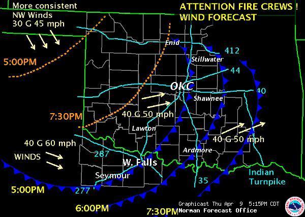
Routine products such as short term forecasts were issued periodically throughout the day, updating the "big picture" forecast elements such as the locations of the dryline and cold fronts, and expectations for temperature, wind, and humidity in the next several hours. By mid afternoon, when satellite imagery and media reports alerted meteorologists to the escalating emergency, it became apparent that fire fighters would need forecasts with a greater level of detail as they planned their attacks. At 3:37 PM, the NWS began issuing Special Weather Statements with the following headline:
     "THIS INFORMATION IS INTENDED TO SUPPORT DECISIONS RELATED
     TO FIRE FIGHTING EFFORTS OVER CENTRAL AND SOUTHERN
     OKLAHOMA AND INTO WESTERN NORTH TEXAS."
These Special Weather Statements, and an accompanying web-based graphic, were updated hourly through midnight. These products contained highly detailed information regarding the location of wind shift boundaries, their estimated arrival times at various locations, and the resulting change in wind direction, wind speed, and gust speed.
Starting at 3:22 PM, Fire Warning messages were transmitted via weather radio at the request of emergency management in several Oklahoma counties. Fire Warnings are a tool that emergency managers can use to disseminate evacuation orders via the NWS, using NOAA All Hazards Weather Radio. These messages describe the area threatened using well known street names, and provide instructions on which direction or along which roads people should travel to remove themselves from the path of the fire. In some cases, the Fire Warning message will include the locations of emergency shelters where evacuees can gather to receive support and information. Unlike any wildfire event seen before, the outbreak on April 9, 2009, required Fire Warnings in rapid succession - almost at the pace that we are accustomed to issuing warnings for severe thunderstorms. At the height of the outbreak, NWS Norman dedicated one meteorologist to the sole task of coordinating and disseminating Fire Warnings. NWS Norman issued eleven Fire Warnings for 8 different communities (some Warnings were updates of previously issued Warnings). The warned communities were all located in Oklahoma, and included Marietta, Wellston, Sparks, Velma, Loco, Midwest City, Bradley, and Lindsay.
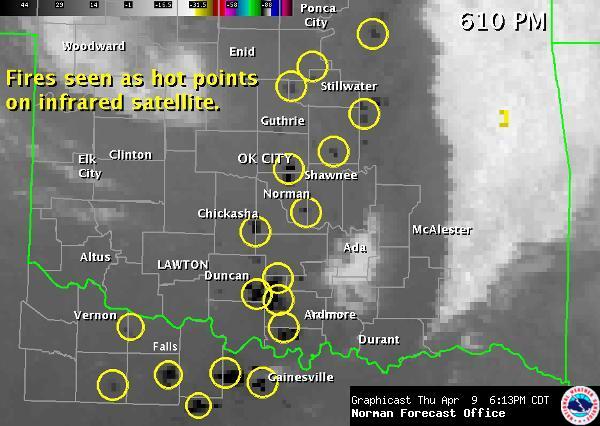
Although Fire Warnings were not issued in western north Texas, infrared satellite heat signatures revealed large wildfires near Electra, Petrolia, and Lake Arrowhead, and NWS Norman collaborated with Texas fire officials by phone throughout the evening. In fact, the NWS provided weather briefings by phone to fire fighters, emergency managers, and media partners, almost continuously between 3 PM and 9 PM.
Preliminary news reports indicate that as a result of the April 9, 2009, wildfires, in Oklahoma 49 people were injured and more than 140 homes were destroyed. Initial estimates state that at least 52,000 acres were burned. Numerous outbuildings were also destroyed. The counties that experienced the greatest impact were Oklahoma County in Midwest City, Carter County, Grady County, Stephens County in Velma and Loco, McClain County, and Garvin County.
Throughout the entire event, forecasters constantly monitored the situation, keeping the fire crews, emergency responders, and the State Forestry Commission up to date on the changing weather conditions by updating graphicasts and utilizing multiple communication devices and media websites. The office was fully staffed, and, in fact, juggled the additional threat posed by thunderstorms, some of which produced large hail in Kay and Hughes Counties, and damaging wind gusts in Woodward and Blaine Counties. Infrared satellite and radar imagery below shows multiple wildfire hot spots and smoke plumes, respectively.
The staff at the National Weather Service Office in Norman extends their sympathy to those who were injured or displaced from their homes by the wildfires of April 9, 2009.
Below are examples of the graphics that were issued prior to and during the April 9, 2009 wildfire event.


