
Heat expands across the Desert Southwest, Plains, Mississippi Valley and Midwest into Monday. Fire weather concerns continue for portions of the Intermountain West. Active monsoonal moisture fuels thunderstorms over the Southwest with possible flash flooding. Tropical cyclone Fausto in the Pacific, should weaken as it approaches Hawaii; Dangerous surf, swells and rip currents are expected. Read More >
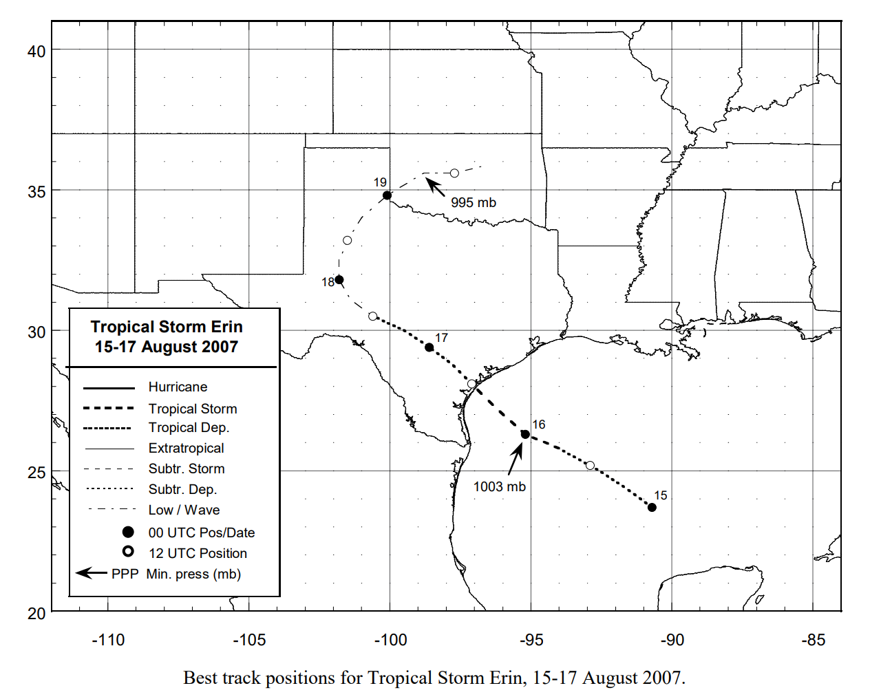
Erin, the fifth named storm of the 2007 Atlantic Hurricane Season, made landfall in the morning hours of Thursday, August 16th, close to Corpus Christi, Texas. The low pressure system then pushed gradually northwest over the Edwards Plateau region of South-Central Texas through Friday Night, before curving back to the northeast over the West Texas Plains on Saturday.
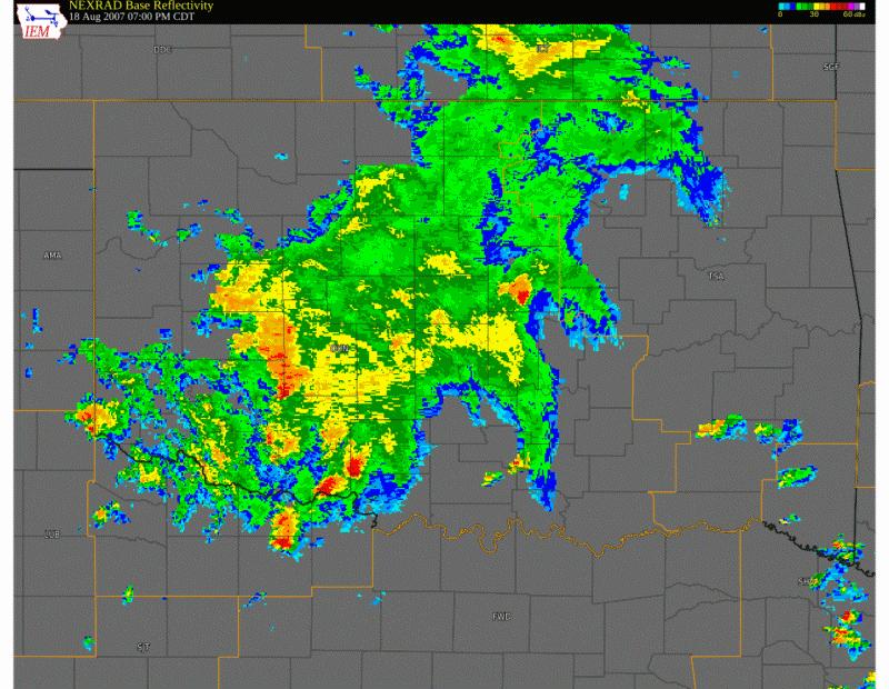
On Saturday Afternoon, August 18th, the low pressure system was approaching the National Weather Service Norman's County Warning Area. By 10 PM local time on Saturday, the low had entered Southwest Oklahoma near Altus. It proceeded to track northeastward over Southwest and Central Oklahoma, eventually pushing east of the Oklahoma City metropolitan area by around noon Sunday. However, during the overnight hours Saturday, the low pressure system deepened as it tracked over the western two-thirds of Oklahoma, and thus produced a variety of hazardous weather.
For more information on the tropical nature of this storm, visit the National Hurricane Center website, where a discussion of Erin's entire lifespan is now available. For various statistics compiled after the event, check the WFO Norman Public Information Statement from August 21st. Descriptions of the hazardous weather impacts to Western and Central Oklahoma are detailed in linked pages on the menu to the left.
NOUS44 KOUN 210607 AAA
PNSOUN

PUBLIC INFORMATION STATEMENT...UPDATED...
NATIONAL WEATHER SERVICE NORMAN OK
105 AM CDT TUE AUG 21 2007

OKZ004>048-050>052-TXZ083>090-202100-
105 AM CDT TUE AUG 21 2007

...IMPACT OF TROPICAL DEPRESSION ERIN...
TROPICAL STORM ERIN FORMED IN THE WESTERN Gulf of America AS TROPICAL
DEPRESSION FIVE TUESDAY EVENING AUGUST 14. IT STRENGTHENED AND WAS
NAMED TROPICAL STORM ERIN WEDNESDAY MORNING AUGUST 15. ERIN MOVED
ONSHORE NEAR LAMAR TEXAS ON THURSDAY MORNING... WEAKENED TO A
TROPICAL DEPRESSION AND MOVED WEST AND NORTHWEST THROUGH SOUTHERN
AND WESTERN TEXAS BEFORE TURNING TO THE NORTHEAST. THE CENTER OF
CIRCULATION FROM TROPICAL DEPRESSION ERIN ENTERED SOUTHWEST OKLAHOMA
BETWEEN HOLLIS AND ERICK LATE SATURDAY NIGHT. IT BECAME MUCH BETTER
ORGANIZED BETWEEN 1 AM AND 7 AM SUNDAY AS IT MOVED FROM NEAR
CLINTON TO NEAR GEARY AND ACROSS NORTHERN CANADIAN COUNTY INTO
NORTHWEST OKLAHOMA CITY. IT BEGAN TO WEAKEN AGAIN AS IT MOVED
EAST THROUGH NORTHERN OKLAHOMA COUNTY SUNDAY MORNING... ALTHOUGH
VERY HEAVY RAIN PERSISTED IN CENTRAL OKLAHOMA THROUGH MIDDAY SUNDAY.

...MAXIMUM WINDS...
WIND    LOCATION         COUNTY     TIME           SOURCE

82 MPH WATONGA           BLAINE     254 AM SUNDAY  AWOS - MEASURED
80 MPH 1 S UNION CITY    CANADIAN   240 AM SUNDAY  SPOTTER -ESTIMATED
75 MPH 4 NNW FORT COBB   CADDO      1225 AM SUNDAY MESONET - MEASURED
73 MPH 7 W WATONGA       BLAINE     225 AM SUNDAY  MESONET - MEASURED
70 MPH 6 S FORT COBB     CADDO      1210 AM SUNDAY SPOTTER - MEASURED
64 MPH 7 W HINTON        CADDO      130 AM SUNDAY  MESONET - MEASURED
62 MPH 4 ENE APACHE      CADDO      1235 AM SUNDAY MESONET - MEASURED
60 MPH 2 NE KINGFISHER   KINGFISHER 425 AM SUNDAY  MESONET - MEASURED
58 MPH 2 SSW MINCO       GRADY      310 AM SUNDAY  MESONET - MEASURED
56 MPH WILL ROGERS ARPT  OKLAHOMA   424 AM SUNDAY  ASOS - MEASURED
56 MPH WILEY POST ARPT   OKLAHOMA   422 AM SUNDAY  ASOS - MEASURED
55 MPH 4 WSW WEATHERFORD CUSTER     1200 AM SUNDAY MESONET - MEASURED

...SOME RAINFALL TOTALS...
RAIN  LOCATION           COUNTY       SOURCE

11.03 9.8 WNW GEARY      BLAINE       COCORAHS OBSERVER
9.30  4 NNW FORT COBB    CADDO        MESONET
9.11  WATONGA            BLAINE       COOP OBSERVER
8.84  SEDAN              KIOWA        COOP OBSERVER
8.68  7.9 ESE NORMAN     CLEVELAND    COCORAHS OBSERVER
8.50  WALTERS            COTTON       COOP OBSERVER
8.45  5 WNW EL RENO      CANADIAN     MESONET
8.15  LOOKEBA            CADDO        COOP OBSERVER
7.67  NORMAN (NWS)       CLEVELAND    NATIONAL WEATHER SERVICE
7.45  2 NE COX CITY      GRADY        COOP OBSERVER
7.31  1.5 WNW NOBLE      CLEVELAND    COCORAHS OBSERVER
7.11  SHAWNEE            POTTAWATOMIE COOP OBSERVER
6.94  CHANDLER           LINCOLN      COOP OBSERVER
6.80  MINCO              GRADY        COOP OBSERVER
6.56  3 N PIEDMONT       CANADIAN     COOP OBSERVER
6.53  4 ESE WEATHERFORD  CUSTER       MESONET
6.44  WICHITA MTN NWR    COMANCHE     RAWS STATION
6.44  4 WNW RUSH SPRINGS GRADY        MESONET
6.20  DUNCAN AIRPORT     STEPHENS
6.18  3 NE COLONY        WASHITA      COOP OBSERVER
6.18  CHICKASHA          GRADY        COOP OBSERVER
6.15  1 WSW MARLOW       STEPHENS     COOP OBSERVER
6.02  5 W MEEKER         LINCOLN      COOP OBSERVER
5.98  6 WNW DEER CREEK   OKLAHOMA     COOP OBSERVER
5.96  2 SSW BLANCHARD    MCCLAIN      COOP OBSERVER
5.91  OKARCHE            KINGFISHER/CANADIAN  COOP OBSERVER
5.68  KINGFISHER         KINGFISHER   MESONET
5.68  3 SE UNION CITY    CANADIAN     COOP OBSERVER
5.52  4 S TECUMSEH       POTTAWATOMIE COOP OBSERVER
5.38  OKLAHOMA CITY      OKLAHOMA     OFFICIAL OBSERVATION AT
                                        WILL ROGERS WORLD AIRPORT
5.14  SHAWNEE            POTTAWATOMIE MESONET
5.12  2 W LINDSAY        GARVIN       COOP OBSERVER

...RIVER FLOODING...
                                   CREST      TIME            FLOOD
                                                              STAGE
..RECORD FLOODING..
NORTH CANADIAN RIVER NEAR WATONGA  19.70 FEET 530 AM SUNDAY   15 FEET
  PREVIOUS RECORD CREST WAS 19.24 FEET ON OCTOBER 3 1986

..MAJOR FLOODING..
NORTH CANADIAN RIVER NEAR EL RENO  23.33 FEET 1 PM MONDAY     17 FEET
  HIGHEST CREST MEASURED SINCE 1923 AT EL RENO
CANADIAN RIVER NEAR BRIDGEPORT     21.03 FEET 330 PM SUNDAY   14 FEET
  HIGHEST CREST MEASURED SINCE 1948 AT BRIDGEPORT
CANADIAN RIVER NEAR UNION CITY     13.50 FEET 230 PM MONDAY   7 FEET
  HIGHEST CREST MEASURED SINCE 1937 AT UNION CITY
CANADIAN RIVER NEAR PURCELL        15.00 FEET 1100 PM TUESDAY 12 FEET
WASHITA RIVER NEAR CARNEGIE        30.81 FEET 1200 PM SUNDAY  25 FEET
WASHITA RIVER AT ANADARKO          26.02 FEET 830 AM MONDAY   19 FEET
  HIGHEST CREST MEASURED SINCE 1949 AT ANADARKO
WASHITA RIVER NEAR CHICKASHA       26.27 FEET 8 AM TUESDAY    19 FEET
EAST CACHE CREEK NEAR WALTERS      27.86 FEET 630 AM MONDAY   21 FEET

...TORNADOES...
TORNADOES AND POSSIBLE TORNADOES BEING INVESTIGATED. NOT ALL
TORNADOES ON THIS LIST HAVE BEEN CONFIRMED YET.

BEGIN/END      DAY        TORNADO PATH            COUNTY/STATE
  TIME

446-457 PM   SATURDAY  5.5 ESE - 6 NE HOBART     KIOWA COUNTY OK
510-520 PM   SATURDAY  10 SSE - 6 SSE CORDELL    WASHITA COUNTY OK
753-757 PM   SATURDAY  1 NNE - 2 NNE THORNBERRY  CLAY COUNTY TX
             SATURDAY  2.5 SSW - 2.5 WSW NORGE   GRADY COUNTY OK
             SUNDAY    1 ENE COGAR - 9.2 W UNION CITY
                                                 CADDO/CANADIAN OK
232-239 AM   SUNDAY    1 ESE MINCO - 1 N UNION CITY
                                                 GRADY/CANADIAN OK


$$

UPDATED RAINFALL AND RIVER DATA.
|
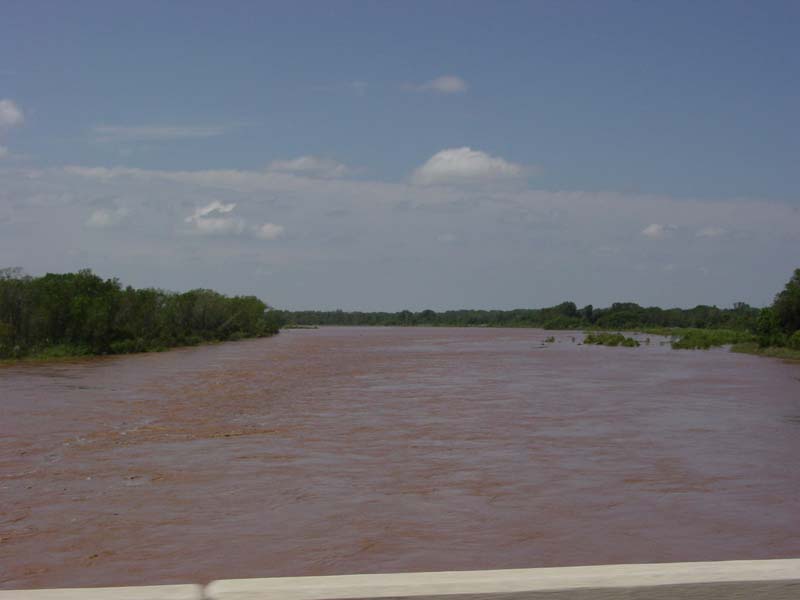
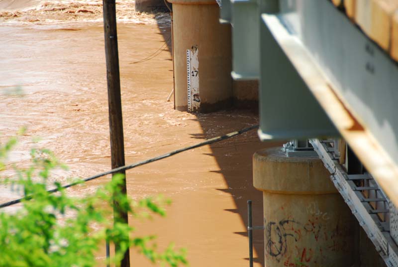
The Canadian River had three different gages exceed flood stage as a result of the heavy rainfall August 18-19. Some of the gages went into major flood stage. All three of the gages experienced crests that were in the top five highest of all time at their respective stations. Several of the stations (Bridgeport and Union City) have not experienced crests that high in the past half-century. Bridgeport had a record crest, which broke a record that had been held since 1914, or for 93 years! The "impact descriptions" provided were taken from the AHPS website and describe theoretical conditions at a certain river stage at a given location.
EXCEEDED BANKFULL:  N/A            EXCEEDED FLOOD STAGE:  N/A
  CRESTED:  21.03 FT  08/19  330PM
  RECORD FLOODING OCCURRED
  IMPACT DESCRIPTION: AT 21 FEET...FLOODING AFFECTS CROPLANDS...PASTURES...AND
                      OIL WELLS NEAR THE RIVER. FLOOD PLAIN FIELDS AT HIGHER
                      ELEVATIONS AWAY FROM THE RIVER MAY BE CUT OFF FROM EASY
                      ACCESS BY HIGH WATER IN SIDE CHANNELS. SAND DREDGING
                      OPERATIONS ARE AFFECTED. UPSTREAM POINTS IN SOUTHERN
                      BLAINE COUNTY MAY SEE FLOODING BEFORE THE AREAS NEAR
                      BRIDGEPORT IN NORTHERN CADDO COUNTY. DOWNSTREAM POINTS
                      IN SOUTHWESTERN CANADIAN COUNTY ARE AFFECTED HOURS LATER.

  NOTES:              THE CREST OF 21.03 FEET BREAKS THE PREVIOUS RECORD OF 19.40
                      FEET WHICH WAS SET ON MAY 3 1914. THEREFORE...FLOODING THIS
                      SEVERE HAS NOT BEEN EXPERIENCED AT BRIDGEPORT IN THE LAST
                      93 YEARS.
 View of the bridge where the staff gage View of the bridge where the staff gageis sited during the flooding. |
 View of the bridge where the staff gage View of the bridge where the staff gageis sited during low flow. |
  EXCEEDED BANKFULL:  N/A            EXCEEDED FLOOD STAGE:  N/A
  CRESTED:  13.50 FT  08/20  230PM
  MAJOR FLOODING OCCURRED
  IMPACT DESCRIPTION: AT 13 FEET...VALLEY-WIDE FLOODING WITH DEPTHS UP TO 6 FEET
                      OCCURS ALONG THE RIVER ON THE CANADIAN-GRADY COUNTY BORDER
                      FROM NEAR U.S. HIGHWAY 81 BETWEEN UNION CITY AND MINCO TO
                      NEAR TUTTLE. AGRICULTURAL LANDS AND LOCAL ROADS ARE THE
                      AREAS MOST AFFECTED ALONG THE CANADIAN RIVER.

  NOTES:              THE CREST OF 13.50 FEET IS THE THIRD HIGHEST ALL TIME
                      AT UNION CITY. THERE HAS NOT BEEN A CREST THIS HIGH SINCE
                      MAY 31 1937...OR IN THE LAST 70 YEARS.
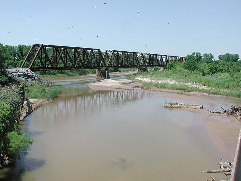
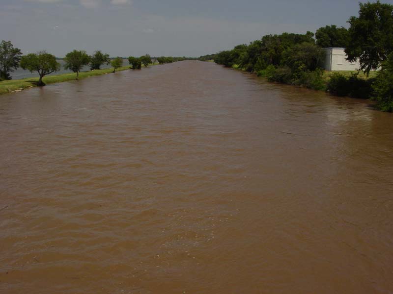
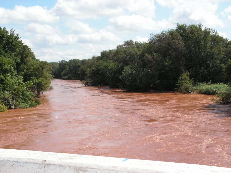
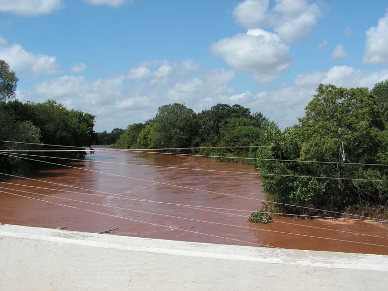
Most of these pictures were taken along U.S. Interstate Highway I-35 near the Norman, OK river gage, although the last photo was taken at the Purcell, OK forecast point site just east of Purcell.
 Looking downstream at the Canadian River from U.S. Interstate Highway I-35. Looking downstream at the Canadian River from U.S. Interstate Highway I-35. |
 Also looking downstream at the Canadian River from U.S. Interstate Highway I-35. Also looking downstream at the Canadian River from U.S. Interstate Highway I-35. |
 Looking upstream at the Canadian River from U.S. Interstate Highway I-35. Looking upstream at the Canadian River from U.S. Interstate Highway I-35. |
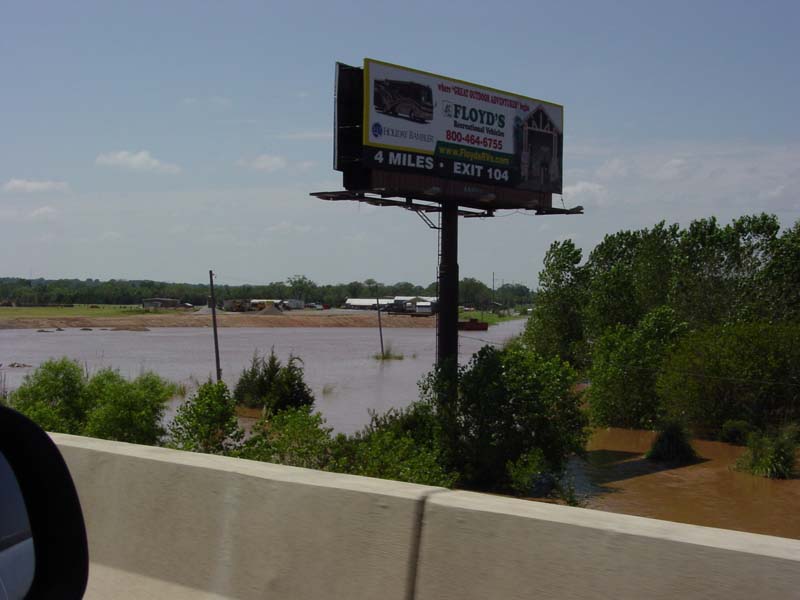 Also looking upstream at the Canadian River from U.S. Interstate Highway I-35. Also looking upstream at the Canadian River from U.S. Interstate Highway I-35. |
 Picture of the staff gage at the Purcell river gage site. Picture of the staff gage at the Purcell river gage site. |
  EXCEEDED BANKFULL:  N/A            EXCEEDED FLOOD STAGE:  N/A
  CRESTED:  15.40 FT  08/21  1100PM
  MAJOR FLOODING OCCURRED
  IMPACT DESCRIPTION: NOT AVAILABLE

  NOTES:              THE CREST OF 15.40 FEET IS THE SECOND HIGHEST ALL TIME
                      AT PURCELL. THERE HAS NOT BEEN A CREST THIS HIGH SINCE
                      MAY 3 1990.
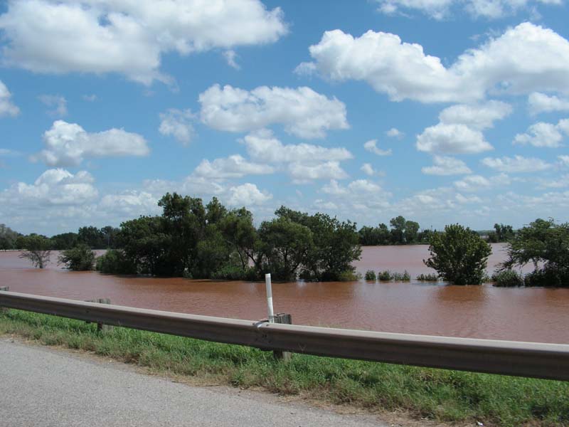
The North Canadian River had five different gages exceed flood stage as a result of the heavy rainfall August 18-19. Some of the gages went into major flood stage, and Watonga even set a record crest in the early morning hours of Sunday, August 19th. El Reno also set a record crest early in the afternoon of Monday August 20th, a record that had been held since 1965. The North Canadian River at Watonga rose from 8.10 feet to 19.70 feet in only 4 hours. All five of the gages experienced crests that were in the top five highest of all time at their respective stations.
  EXCEEDED BANKFULL:  08/19  330AM   EXCEEDED FLOOD STAGE:  08/19 345AM
  CRESTED:  19.70 FT  08/19  530AM
  RECORD FLOODING OCCURRED
  IMPACT DESCRIPTION: AT 20 FEET...FLOODING OF MOSTLY CROPLANDS...
                      PASTURES...AND RURAL ROADS OCCURS. RURAL FLOODING
                      EXTENDS FROM NEAR WATONGA IN BLAINE COUNTY...DOWNSTREAM
                      TO NEAR CALUMET IN WESTERN CANADIAN COUNTY. THE
                      NORTHWEST EDGE OF THE TOWN OF GREENFIELD MAY SEE
                      SHALLOW DEPTHS. NO OTHER TOWNS WILL BE AFFECTED.

  NOTES:              THE CREST OF 19.70 FEET BREAKS THE PREVIOUS RECORD OF
                      19.24 FEET WHICH WAS SET ON OCTOBER 3 1986. THE RIVER
                      AT WATONGA ROSE 11.6 FEET IN THE FOUR HOURS PRIOR TO
                      CRESTING...A RATE OF NEARLY 3 FEET PER HOUR.
  EXCEEDED BANKFULL:  08/19  530AM   EXCEEDED FLOOD STAGE:  08/19 800AM
  CRESTED:  23.33 FT  08/20  100PM
  RECORD FLOODING OCCURRED
  IMPACT DESCRIPTION: AT 23 FEET...FLOOD DEPTHS SEEN IN EL RENO AND NEARBY
                      RAILYARDS ARE THE MOST SEVERE SINCE SEPTEMBER 1965. IN
                      CANADIAN COUNTY...OVERFLOWS COVER APPROXIMATELY 30
                      SQUARE MILES. FLOOD DEPTHS VARYING UP TO 6 FEET ARE
                      DESTRUCTIVE TO SUBURBAN AND RURAL RESIDENCES AND
                      PROPERTIES BETWEEN EL RENO AND YUKON. OTHER AREAS ARE
                      ISOLATED BY LIFE-THREATENING FLOWS ON LOCAL ROADS.

  NOTES:              THE CREST OF 23.33 FEET BREAKS THE PREVIOUS RECORD OF
                      22.22 FEET WHICH WAS SET ON SEPTEMBER 21 1965.
Pictures were taken near the Overholser Dam, just downstream of the Yukon river gage, unless otherwise indicated
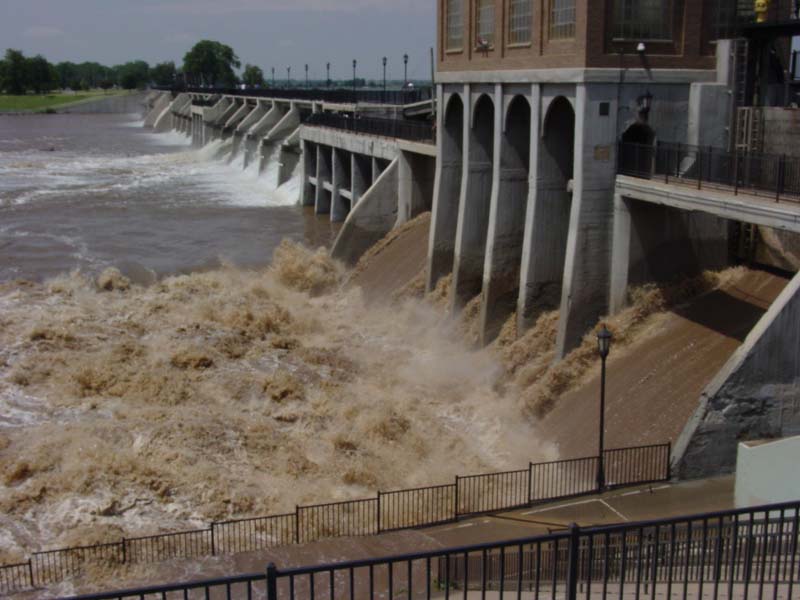 The Overholser Dam while the North Canadian River was flooding. The Overholser Dam while the North Canadian River was flooding. |
 The Lake Overholser Dam Spillway full of water. The Lake Overholser Dam Spillway full of water. |
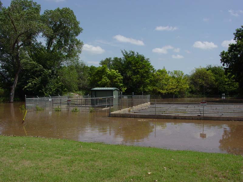 Flooding at a trailer park near the dam. Flooding at a trailer park near the dam. |
  EXCEEDED BANKFULL:  08/19  630AM   EXCEEDED FLOOD STAGE:  08/19 230PM
  CRESTED:  16.51 FT  08/21  430AM
  MODERATE FLOODING OCCURRED
  IMPACT DESCRIPTION: AT 16 FEET...FLOODING OR ISOLATION OF SUBURBAN HOME
                      SITES AND RURAL AREAS ALONG THE NORTH CANADIAN RIVER
                      VALLEY OCCURS...FROM NEAR BANNER ROAD TO THE HEADWATERS
                      OF LAKE OVERHOLSER. THE GARTH BROOKS AVENUE CROSSING
                      NORTHWEST OF TOWN IS CLOSED BY FLOODWATERS. LOW-LYING
                      RURAL ROADS ARE CLOSED BY FLOOD DEPTHS NEAR 4 FEET WITH
                      DANGEROUSLY SWIFT CURRENTS.

  NOTES:              THE CREST OF 16.51 FEET IS THE THIRD HIGHEST ALL TIME
                      AT YUKON. THE RECORD...19.20 FEET...WAS SET ON
                      JUNE 10 1995. AN INITIAL CREST OF 16.21 FEET OCCURRED
                      ON AUGUST 19TH. THE RIVER THEN FELL AND CRESTED AGAIN
                      AT 16.51 FEET ON AUGUST 21ST. THE INITIAL CREST OF 16.21
                      FEET WAS THE FOURTH HIGHEST ALL TIME.
  EXCEEDED BANKFULL:  08/19  645AM   EXCEEDED FLOOD STAGE:  08/19 700AM
  CRESTED:  22.38 FT  08/22  630AM
  MODERATE FLOODING OCCURRED
  IMPACT DESCRIPTION: AT 22 FEET...CROPLANDS... PASTURES... AND RURAL ROADS
                      EAST OF OKLAHOMA CITY NEAR THE TOWNS OF SPENCER AND
                      JONES ARE INUNDATED BY SIGNIFICANT OVERFLOW DEPTHS.
                      SPENCER IS NOT AFFECTED BY FLOODWATERS...WHILE SHALLOW
                      FLOODING MAY REACH THE OUTSKIRTS OF JONES.

  NOTES:              THE CREST OF 22.38 FEET IS THE FOURTH HIGHEST ALL TIME
                      AT OKLAHOMA CITY. THE RECORD...24.80 FEET...WAS SET ON
                      MAY 9 1993. AN INITIAL CREST OF 22.09 FEET OCCURRED ON
                      AUGUST 19TH. THE RIVER THEN FELL AND CRESTED AGAIN AT
                      22.38 FEET ON AUGUST 22ND. THE INITIAL CREST OF 22.09
                      FEET WAS THE FIFTH HIGHEST ALL TIME.
  EXCEEDED BANKFULL:  08/19 1130AM   EXCEEDED FLOOD STAGE:  08/19 200PM
  CRESTED:  19.20 FT  08/23  300AM
  MAJOR FLOODING OCCURRED
  IMPACT DESCRIPTION: AT 19 FEET...SIGNIFICANT FLOODING AFFECTS AGRICULTURAL
                      AREAS AND RURAL ROADS IN EASTERN OKLAHOMA COUNTY...THE
                      SOUTHWEST CORNER OF LINCOLN COUNTY...AND NORTHWESTERN
                      POTTAWATOMIE COUNTY.

  NOTES:              THE CREST OF 19.20 FEET IS THE FOURTH HIGHEST ALL TIME
                      AT HARRAH. THE RECORD...21.90 FEET...WAS SET ON
                      MAY 9 1993.
The Washita River had four different gages exceed flood stage as a result of the heavy rainfall August 18-19. Some of the gages went into major flood stage. The Washita River at Anadarko has not had a crest as high as the one on August 20th in the past half-century.
  EXCEEDED BANKFULL:  08/19  100AM   EXCEEDED FLOOD STAGE:  08/19  130AM
  CRESTED:  21.66 FT  08/19  700AM
  MODERATE FLOODING OCCURRED
  IMPACT DESCRIPTION: AT 21 FEET...APPROXIMATELY 5 THOUSAND ACRES OF RURAL
                      LANDS ARE COVERED BY DEPTHS UP TO 3 FEET... FROM AREAS
                      NEAR THE MOUTH OF BARNITZ CREEK...TO NEAR CLINTON IN
                      CUSTER COUNTY...AND DOWNSTREAM INTO WASHITA COUNTY. SOME
                      FARMSTEADS ARE FLOODED AND OTHERS ISOLATED BY WATER OVER
                      LOCAL ROADS. LOW FARM LEVEES MAY BE OVERTOPPED.
  EXCEEDED BANKFULL:  08/19  200AM   EXCEEDED FLOOD STAGE:  08/19  230AM
  CRESTED:  30.81 FT  08/19 1200PM
  MAJOR FLOODING OCCURRED
  IMPACT DESCRIPTION: AT 30 FEET...LOOK FOR WIDE FLOOD PLAIN COVERAGE ALONG THE
                      WASHITA RIVER VALLEY IN EASTERN WASHITA AND WESTERN CADDO
                      COUNTIES. MORE THAN FIVE THOUSAND ACRES OF FARM LANDS ARE
                      COVERED BY FLOOD DEPTHS TO ABOUT 5 FEET. LOCAL HIGHWAYS MAY
                      BE BLOCKED...ISOLATING SOME RURAL COMMUNITIES AND MANY
                      FARMSTEADS.
 View from South Bridge looking Downstream View from South Bridge looking Downstream |
 View from South Bridge looking Upstream View from South Bridge looking Upstream |
  EXCEEDED BANKFULL:  08/19  430AM   EXCEEDED FLOOD STAGE:  08/19  600AM
  CRESTED:  26.02 FT  08/20  830PM
  MAJOR FLOODING OCCURRED
  IMPACT DESCRIPTION: AT 26 FEET...AREAS IN AND NEAR THE ANADARKO CITY PARK ARE
                      FLOODED. FARM LEVEES ARE OVERTOPPED...AND PROPERTY SEVERELY
                      DAMAGED. RURAL ROADS IN CADDO AND WESTERN GRADY COUNTIES
                      ARE CLOSED.

  NOTES:              THE CREST OF 26.02 FEET IS THE THIRD HIGHEST ALL TIME
                      AT ANADARKO. THERE HAS NOT BEEN A CREST THIS HIGH SINCE
                      MAY 27 1949...OR IN THE LAST 58 YEARS.
 View from Highway 81 Bridge looking Downstream View from Highway 81 Bridge looking Downstream |
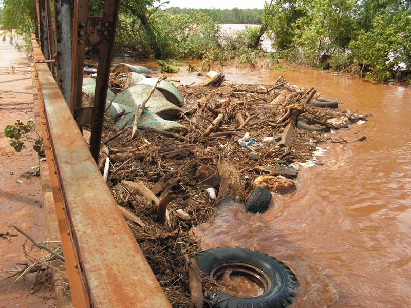 View from Old Highway 81 Bridge, with accumulated debris View from Old Highway 81 Bridge, with accumulated debris |
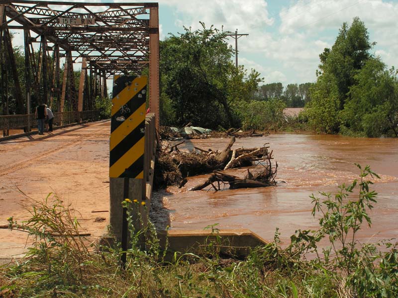 Upstream view looking at the Old Highway 81 Bridge Upstream view looking at the Old Highway 81 Bridge |
Upstream view looking at the Old Highway 81 Bridge |
| Upstream view looking at the Old Highway 81 Bridge |
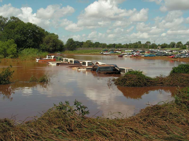 Flooding at the Chickasha Salvage Yard Flooding at the Chickasha Salvage Yard |
  EXCEEDED BANKFULL:  08/19 1015AM   EXCEEDED FLOOD STAGE:  08/20  115AM
  CRESTED:  26.27 FT  08/21  800AM
  MAJOR FLOODING OCCURRED
  IMPACT DESCRIPTION: AT 26 FEET...FLOOD LEVELS UP TO A DEPTH OF 2 FEET AFFECT
                      RESIDENTIAL AREAS IN NORTH CHICKASHA. SUBURBAN HOMES AND
                      BUSINESSES EAST OF TOWN ARE INUNDATED BY GREATER DEPTHS.
                      OVERFLOW DEPTHS ON AGRICULTURAL FIELDS VARY...RANGING UP
                      TO 9 FEET.

  NOTES:              THE CREST OF 26.27 FEET IS THE FOURTH HIGHEST ALL TIME
                      AT CHICKASHA.
Besides the three main rivers that flooded due to the heavy rainfall on August 18-19 (North Canadian, Canadian and Washita), other rivers and creeks also flooded across portions of Western and Central Oklahoma. These rivers only had one or two river gage stations report flooding conditions and therefore they are detailed here, in the "Other Rivers and Creeks" section.
  EXCEEDED BANKFULL:  08/19  715PM   EXCEEDED FLOOD STAGE:  08/20 430AM
  CRESTED:  13.33 FT  08/20  915AM
  MINOR FLOODING OCCURRED
  IMPACT DESCRIPTION: AT 13 FEET...RIVER LEVELS APPROACH BANKFULL LEVELS IN
                      LOGAN AND PAYNE COUNTIES. U.S. HIGHWAY 77 NORTH OF
                      GUTHRIE MAY BE FLOODED. SOME LOW-LYING FIELDS AND OIL
                      WELLS MAY BE ISOLATED...AND CATTLE STRANDED...BY WATER
                      IN CUTOFF CHANNELS.

  NOTES:	      THE CIMARRON RIVER ALSO FLOODED AT PERKINS. THE CREST WAS
                      17.93 FEET AT 624 PM ON AUGUST 20TH. THIS IS CONSIDERED
		      MINOR FLOODING.
  EXCEEDED BANKFULL:  08/19  530PM   EXCEEDED FLOOD STAGE:  08/19 615PM
  CRESTED:  30.12 FT  08/19 1030PM
  MODERATE FLOODING OCCURRED
  IMPACT DESCRIPTION: NONE AVAILABLE

  NOTES:	      COTTONWOOD CREEK ALSO FLOODED AT GUTHRIE. THE CREST WAS
                      26.4 FEET AT 920 AM ON AUGUST 20TH. THIS IS CONSIDERED
                      MODERATE FLOODING.
  EXCEEDED BANKFULL:  08/19 1000AM   EXCEEDED FLOOD STAGE:  08/19 1045AM
  CRESTED:  16.54 FT  08/20  330AM
  MODERATE FLOODING OCCURRED
  IMPACT DESCRIPTION: AT 16 FEET...SIGNIFICANT FLOODING TO DEPTHS OF 5 FEET
                      DAMAGES CROPLANDS...PASTURES...AND RURAL ROADS ALONG
                      THE RIVER DOWNSTREAM OF THE U.S. HIGHWAY 177 BRIDGE
                      CROSSING...WITH LESSER DAMAGE OCCURRING UPSTREAM OF U.S.
                      HIGHWAY 177. THE AREA AFFECTED IS ENTIRELY RURAL.
  EXCEEDED BANKFULL:  08/19  530AM   EXCEEDED FLOOD STAGE:  08/19  745AM
  CRESTED:  21.80 FT  08/19 1245PM
  MINOR FLOODING OCCURRED
  IMPACT DESCRIPTION: NONE AVAILABLE

  NOTES:              THIS IS THE HIGHEST CREST RECORDED AT NINNEKAH SINCE
                      RIVER GAGE READINGS BEGAN.
  EXCEEDED BANKFULL:  08/19  445AM   EXCEEDED FLOOD STAGE:  08/19  615AM
  CRESTED:  27.86 FT  08/20  630AM
  MAJOR FLOODING OCCURRED
  IMPACT DESCRIPTION: AT 27 FEET...VALLEY-WIDE FLOODING OF CROPLANDS...
                      PASTURES...AND LOCAL ROADS OCCURS IN SOUTHERN COMANCHE
                      COUNTY AND COTTON COUNTY AND IS ACCOMPANIED BY FLOOD DEPTHS
                      UP TO 6 FEET WITH VERY DANGEROUS CURRENTS.

  NOTES:	      THE EAST CACHE CREEK AT WALTERS WAS IN MAJOR FLOOD STAGE
                      FOR OVER THREE CONSECUTIVE DAYS.
  EXCEEDED BANKFULL:  08/20  115AM   EXCEEDED FLOOD STAGE:  08/20  1045AM
  CRESTED:  20.76 FT  08/20  730PM
  MINOR FLOODING OCCURRED
  IMPACT DESCRIPTION: AT 20 FEET...SHALLOW FLOODING OCCURS OVER CROPLANDS...
                      PASTURES...AND LOW-LYING LOCAL ROADS ALONG AND NEAR
                      THE CREEK.
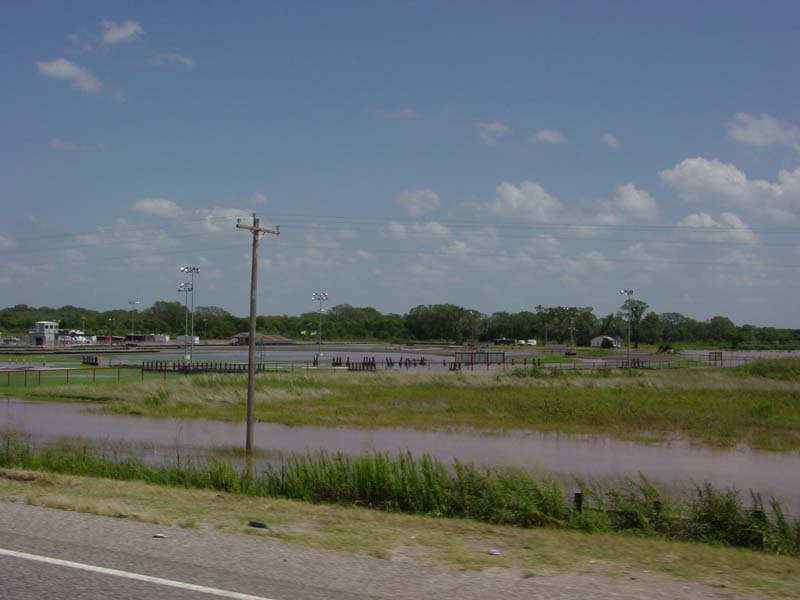
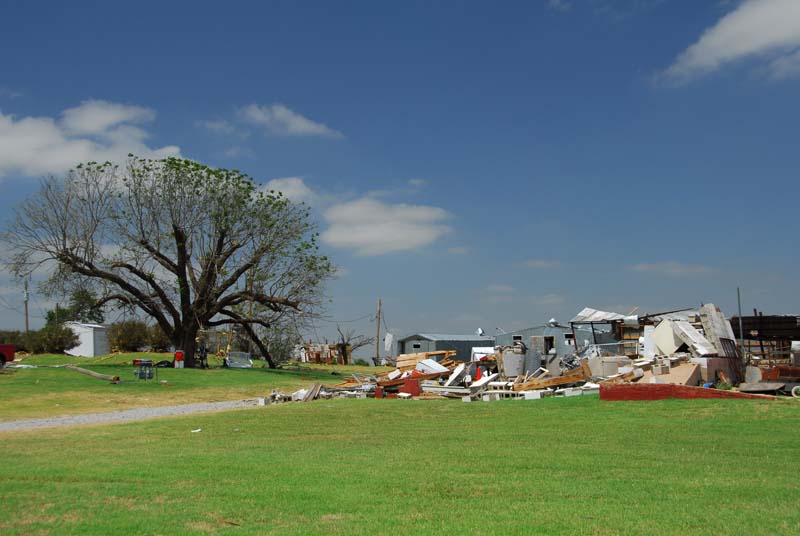
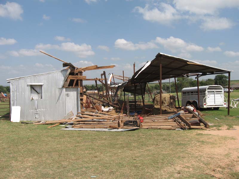
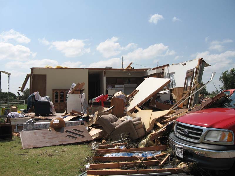
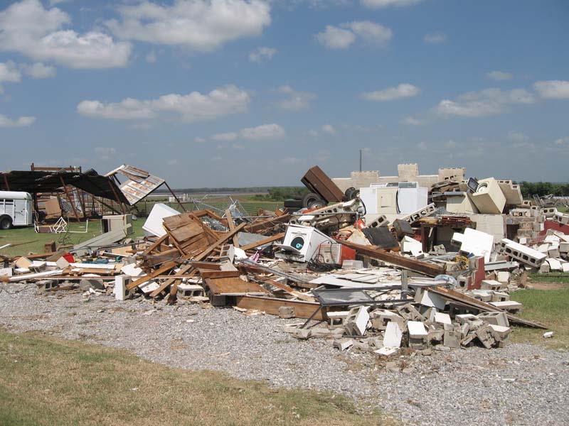
Six fatalities were confirmed to be a direct result of flash flooding caused by Tropical Depression Erin in Western and Central Oklahoma. Five of the six people were in their vehicles when they were swept away by rising waters. For information on flooding safety, the danger of flash flooding to vehicles, and the National Weather Service's "Turn Around Don't Drown" Campaign, click here.
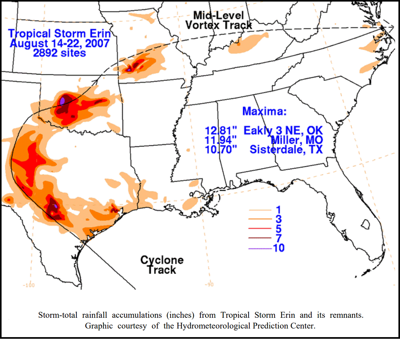
Tropical Depression Erin produced copius amounts of rainfall across Oklahoma, exceeding 9 inches in some locations. The Oklahoma Mesonet station with the highest rainfall total was located 4 miles north-northwest of Fort Cobb; it recorded 9.30 inches of rainfall due to Erin. The highest rainfall total associated with Erin, received by the WFO Norman, was from a COCORAHS observer 9.8 miles north-northwest of Geary; the oberver recorded 11.03 inches of rainfall.
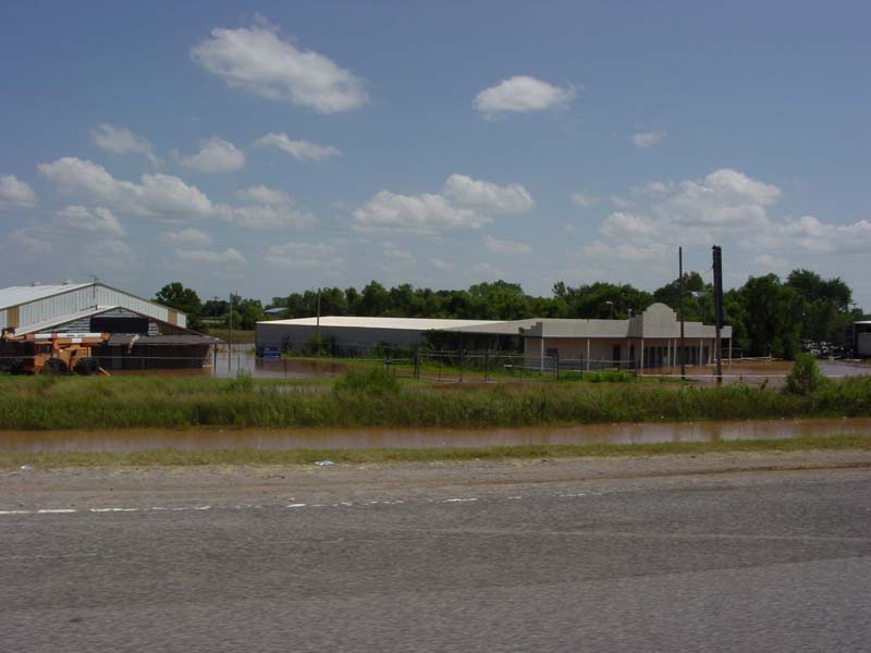
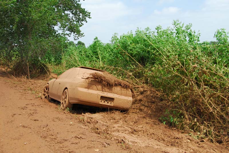
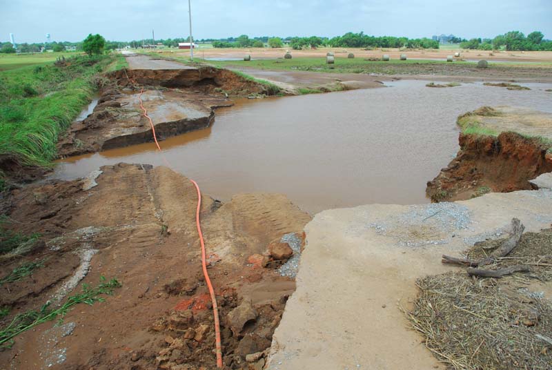
Here are a few pictures of the damage caused by the flash flooding over parts of Oklahoma.
 |
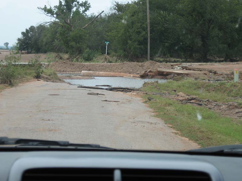 |
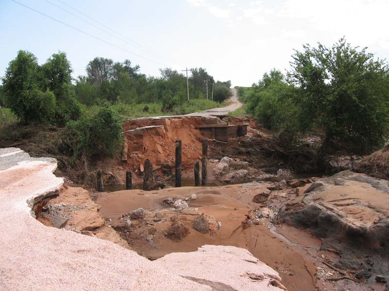
| Left: A bridge washed out when a creek rose quickly. | Right: A portion of a road is washed out and impassable. |
 |
 |
| Left: A car coated with mud after it was submerged in rising flood waters. | Right: Damaged road near Minco. Damage was caused when Buggy Creek rose quickly due to the heavy rainfall. |
The following are local storm reports (LSRs) issued during the event in question. The only LSRs included on this page concern flash flooding and are spliced from the original LSR and are placed in chronological order.
..TIME...   ...EVENT...      ...CITY LOCATION...     ...LAT.LON...
..DATE...   ....MAG....      ..COUNTY LOCATION..ST.. ...SOURCE....
            ..REMARKS..

1055 PM     FLASH FLOOD      HOBART                  35.03N 99.09W
08/18/2007                   KIOWA              OK   EMERGENCY MNGR

            DOT IS IN ROUTE TO CLOSE BUSINESS HWY 9 IN HOBART DUE TO
            HIGH WATER.

1055 PM     FLASH FLOOD      MOUNTAIN VIEW           35.10N 98.75W
08/18/2007                   KIOWA              OK   EMERGENCY MNGR

            HIGHWAY 9 BETWEEN MOUNTAIN VIEW AND CARNEGIE IS CLOSED
            DUE TO HIGH WATER.

1055 PM     FLASH FLOOD      CYRIL                   34.90N 98.20W
08/18/2007                   CADDO              OK   FIRE DEPT/RESCUE

            ONE FOOT OF WATER REPORTED OVER ROAD AT JUNCTION OF HWY
            277 AND HWY 19.

1219 AM     FLASH FLOOD      2 W MOUNTAIN VIEW       35.10N 98.79W
08/19/2007                   KIOWA              OK   EMERGENCY MNGR

            COUNTY EMERGENCY MANAGER IS REPORTED WATER FOUR FEET DEEP
            OVER HWY 9. NUMEROUS OTHER ROADS IN GOTEBO, HOBART, AND
            MOUNTAIN VIEW ARE CLOSED DUE TO THE HIGH WATER.

1226 AM     FLASH FLOOD      4 S CARNEGIE            35.05N 98.60W
08/19/2007                   CADDO              OK   AMATEUR RADIO

            A CAR WAS WASHED OFF OF HWY 58 FOUR MILES SOUTH OF
            CARNEGIE. ANOTHER CAR WAS WASHED OFF THE ROADWAY SIX
            MILES SOUTH OF CARNEGIE.

0315 AM     FLASH FLOOD      5 E MOUNTAIN VIEW       35.10N 98.66W
08/19/2007                   KIOWA              OK   EMERGENCY MNGR

            HOUSE AND TWO VEHICLES REPORTED WASHED AWAY BY RISE IN
            STINKING CREEK... ALTHOUGH OFFICIALS COULD NOT GET TO THE
            LOCATION DUE TO THE CONTINUED FLOODING. FLOOD WATER IS 5
            FEET DEEP AND STILL RISING /AT 415 AM/ NEAR LOCATION OF
            THE HOUSE.

0320 AM     FLASH FLOOD      4 ESE MOUNTAIN VIEW     35.08N 98.68W
08/19/2007                   KIOWA              OK   AMATEUR RADIO

            WATER RESCUES OCCURRING APPROXIMATELY 1 MILE S OF HWY 9
            ON COUNTY RD 2420. A 0.5 SECTION OF HWY 9 STILL CLOSED.
            STINKING CREEK OUT OF ITS BANKS.

0330 AM     FLASH FLOOD      1 W TUTTLE              35.29N 97.83W
08/19/2007                   GRADY              OK   PUBLIC

            SEVERAL FEET OF WATER COVERING HWY 37

0345 AM     FLASH FLOOD      EL RENO                 35.53N 97.95W
08/19/2007                   CANADIAN           OK   BROADCAST MEDIA

            HWY 81 CLOSED NEAR I-40 DUE TO WATER. SEMI AND CAR
            STRANDED. REPORTED BY KOCO TV.

0436 AM     FLASH FLOOD      YUKON                   35.51N 97.75W
08/19/2007                   CANADIAN           OK   EMERGENCY MNGR

            HIGHWAYS 4 AND 92 CLOSED DUE TO FLOODING.

0459 AM     FLASH FLOOD      2 SW EAKLY              35.29N 98.58W
08/19/2007                   CADDO              OK   TRAINED SPOTTER

            HWY 152 IMPASSABLE DUE TO HIGH WATER 1/2 E OF HWY 58

0500 AM     FLASH FLOOD      NORMAN                  35.22N 97.44W
08/19/2007                   CLEVELAND          OK   NWS EMPLOYEE

0500 AM     FLASH FLOOD      3 SE THOMAS             35.72N 98.71W
08/19/2007                   CUSTER             OK   EMERGENCY MNGR

            ROAD WASHED OUT

0534 AM     FLASH FLOOD      KINGFISHER              35.86N 97.93W
08/19/2007                   KINGFISHER         OK   EMERGENCY MNGR

            4 FEET OF WATER FLOWING OVER HIGHWAY 33 IN KINGFISHER. 4
            TO 5 FEET OF WATER FLOWING OVER HIGHWAY 81 BETWEEN
            KINGFISHER AND DOVER. CARS STALLED DUE TO WATER OVER
            HIGHWAY 81 NORTH OF OKARCHE.

0535 AM     FLASH FLOOD      OKLAHOMA CITY           35.47N 97.51W
08/19/2007                   OKLAHOMA           OK   BROADCAST MEDIA

            SEVERAL FEET OF WATER AT NW 36TH AND BROADWAY. FOUR CARS
            STRANDED.

0630 AM     FLASH FLOOD      NORMAN                  35.22N 97.44W
08/19/2007                   CLEVELAND          OK   EMERGENCY MNGR

            HOMES FLOODED ON LAHOMA STREET. NUMEROUS ROADS IN NORMAN
            FLOODED.

0900 AM     FLASH FLOOD      KINGFISHER              35.86N 97.93W
08/19/2007                   KINGFISHER         OK   BROADCAST MEDIA

1000 AM     FLASH FLOOD      SHAWNEE                 35.34N 96.92W
08/19/2007                   POTTAWATOMIE       OK   EMERGENCY MNGR

1215 PM     FLASH FLOOD      SEMINOLE                35.23N 96.67W
08/19/2007                   SEMINOLE           OK   EMERGENCY MNGR

            FLOODING IN TOWN, AS WELL AS ACROSS OTHER PORTIONS OF THE
            COUNTY.
|
The following table provides information concerning the tornadoes that occurred during the late evening August 18th and and early morning of August 19th, associated with Tropical Depression Erin. Five tornadoes occurred over the WFO Norman County Warning Area, 3 of which were rated an EF-1 and 2 rated an EF-0.
Specific information is available for the Norge and Minco tornadoes after the tornado table.
| August 18-19, 2007 Tornadoes by Intensity | |||||||
| EF? | EF0 | EF1 | EF2 | EF3 | EF4 | EF5 | Total |
| 0 | 2 | 3 | 0 | 0 | 0 | 0 | 5 |
| Tornado Number |
Date | Time (CST) |
Length of Path (miles) |
Width of Path (yards) |
F-Scale | Killed | Injured | County | Location |
|---|---|---|---|---|---|---|---|---|---|
| 1 | 08/18/2007 | 1546-1557 | 6 | 50 | EF1 | 0 | 0 | Kiowa | 5.5 ESE Hobart - 6 NE Hobart |
| 2 | 08/18/2007 | 1610-1620 | 4 | 30 | EF0 | 0 | 0 | Washita | 10 SSE - 6 SSE Cordell |
| 3 | 08/18/2007 | 1944-1948 | 2 | 30 | EF1 | 0 | 0 | Grady | 2.5 SSW Norge - 1.8 E Laverty |
| 4 | 08/19/2007 | 0100-0106 | 3 | 30 | EF0 | 0 | 0 | Caddo/ Canadian | 1.7 ENE Cogar - 9 W Union City |
| 5 | 08/19/2007 | 0132-0138 | 7 | 75 | EF1 | 0 | 0 | Grady/ Canadian | 1 ESE Minco - 1 N Union City |
This tornado spun up at about 8:44 PM CDT on August 18, 2007, 2.5 miles south-southwest of Norge. It then tracked northwest and eventually dissipated at about 8:48 PM CDT, 1.8 miles east of Laverty. Several trees were snapped and a mobile home was damaged. Damage photos are available below. This tornado was rated an EF-1 on the Enhanced Fujita Scale. Click on the pictures for larger versions.
 |
 |
This tornado spun up at about 2:32 AM CDT 1 mile east-southeast of Minco. It then tracked north-northwest through the northeast side of Minco, and eventually dissipated at about 2:38 AM CDT 1 mile north of Union City. Along its path, the tornado hit a small neighborhood. For the most part, it just caused some roof and tree damage, with a few evergreen trees snapped. In addition, one mobile home was tossed a short distance, another was moved, and two more sustained some structural damage. Based on the damage, this tornado has been assigned a rating of EF-1 on the Enhanced Fujita Scale. Click on the images below for larger versions.
 |
 |
 |
 |
 |
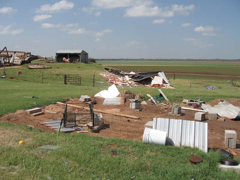 |
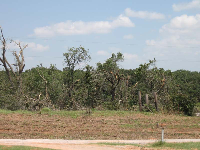
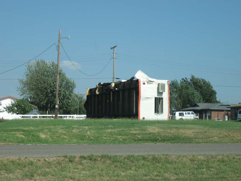
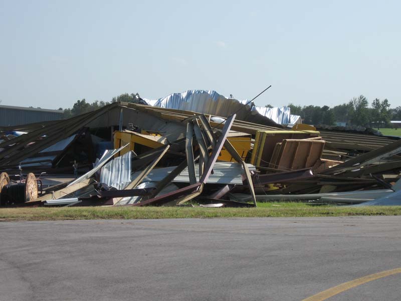
As the low associated with Tropical Depression Erin deepened into the early morning hours of August 19th, it passed roughly over Southern Blaine County or the Watonga and Geary area. The deepening low passing through Oklahoma was already contributing to breezy overnight conditions, but persistent thunderstorm activity in the Geary/Watonga area aided in producing severe and destructive wind gusts that lasted for several hours.
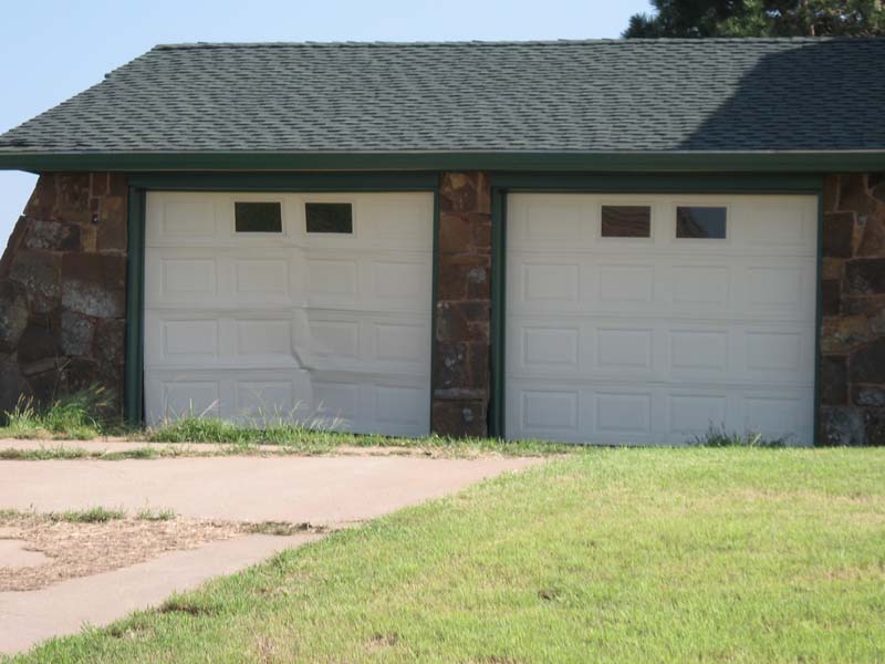
In Geary, tree damage was fairly widespread. Some structural damage to homes and businesses also occurred. A retirement home lost a section of its roof and a neighboring home had siding peeled off and its garage door blown in. A mobile home on the east side of town was blown over. There was some damage to a convenience store and the siding on the canopy was peeled but still attached. Based on the damage found, winds in Geary probably peaked in the 80 to 85 mph range.
 Flipped mobile home on the east side of town |
 Garage door blown inward. |
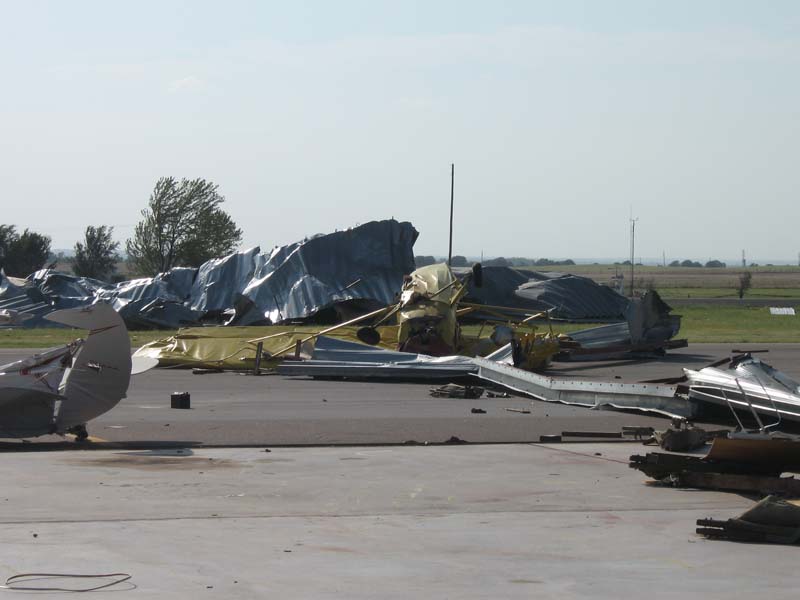
To the north, between Watonga and Geary, there was some tree and minor structural damage visible from Highway 281. In Watonga, the damage was not nearly as widespread as in Geary but there was still some structural damage found. Power poles were found to be leaning or blown down all around the city. The north side of Watonga seemed to have the most widespread wind damage. The Watonga Airport had several hangers completely destroyed and some airplanes damaged. Two light towers at the high school baseball field were collapsed and one was bent. Tree damage around the city was fairly widespread. Based on the damage found, and the ASOS station at the Watonga airport recording an 82-mph wind gust before failing, winds in Watonga probably peaked in the 85 to 95 mph range.
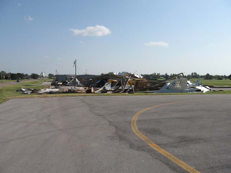 Destroyed hangar at Watonga Regional Airport |
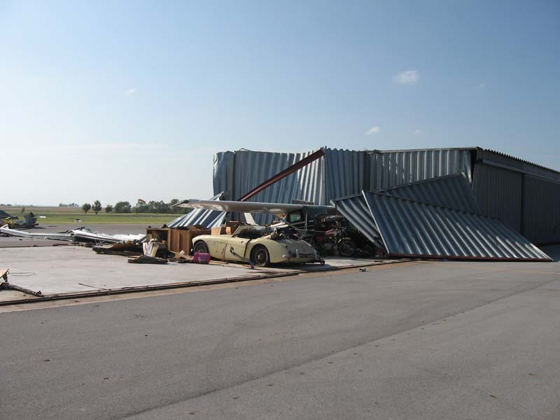 Destroyed hangar at Watonga Regional Airport |
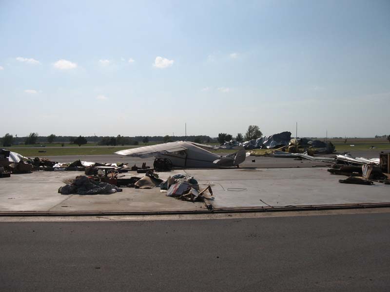 Damaged and flipped airplanes |
 Zoomed in version of right side of previous picture. |
 Debris in destroyed hangar |
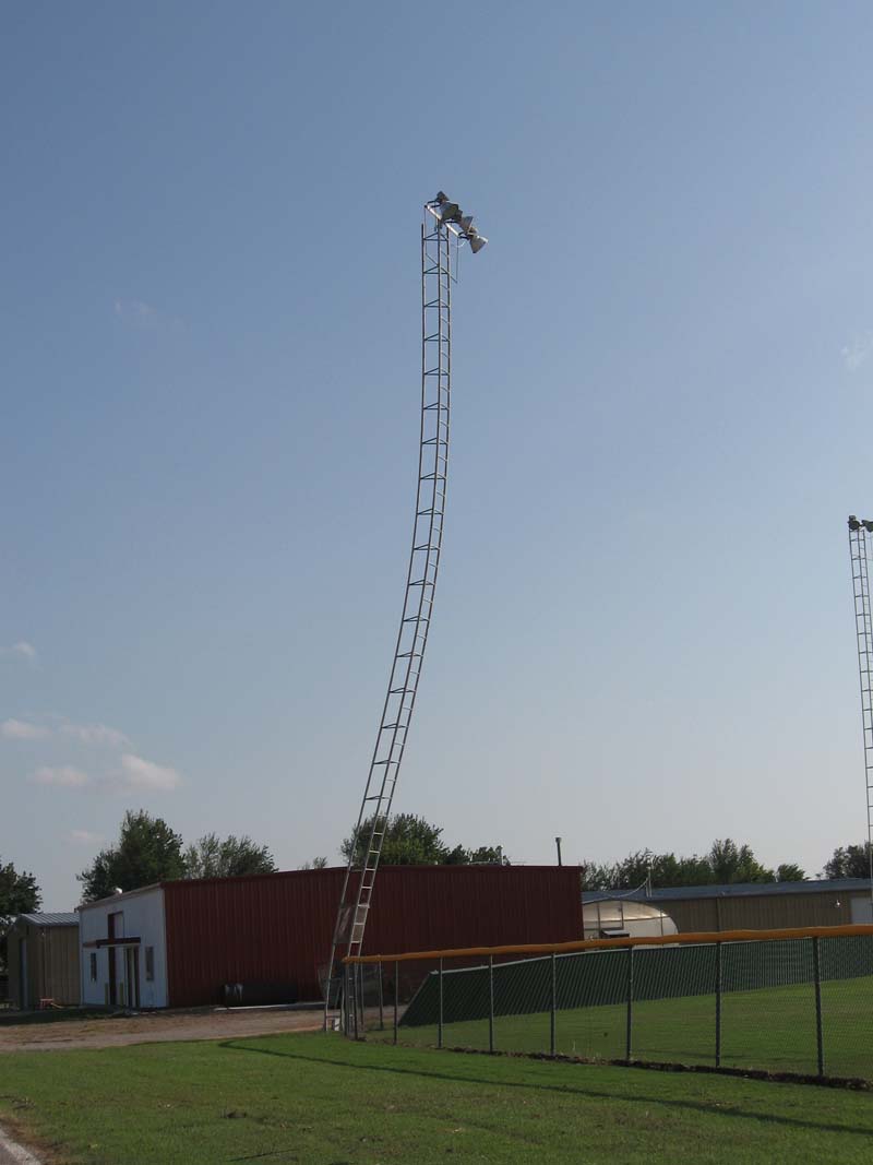 Bent light pole at high school baseball field |
Below is a map with locations of some of the wind gust reports that we received as the remnants of Tropical Storm Erin passed over our area.
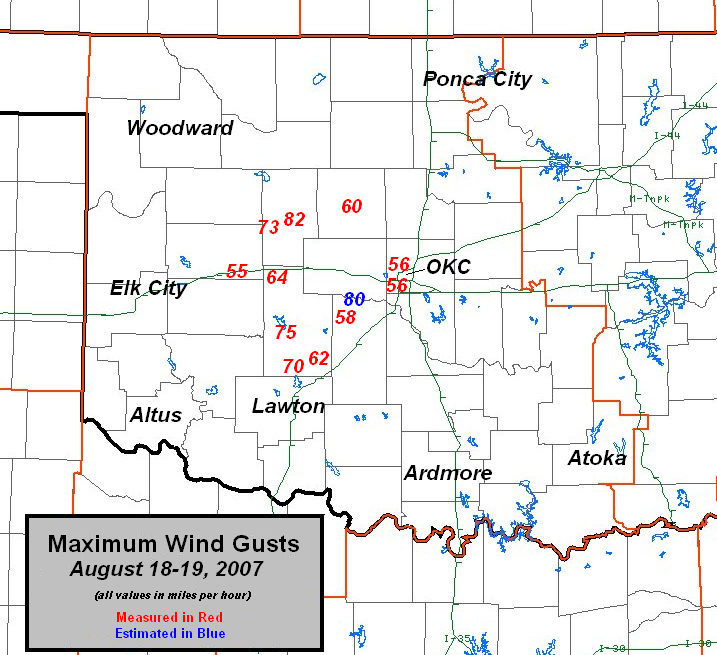
Maximum wind gusts associated with thunderstorm activity on August 18-19, 2007.
The following wind gust reports were taken from the Public Information Statement issued shortly after the event. For the entire Public Information Statement, please click on the link on the left hand navigation menu.
WIND    LOCATION         COUNTY     TIME           SOURCE

82 MPH WATONGA           BLAINE     254 AM SUNDAY  AWOS - MEASURED
80 MPH 1 S UNION CITY    CANADIAN   240 AM SUNDAY  SPOTTER -ESTIMATED
75 MPH 4 NNW FORT COBB   CADDO      1225 AM SUNDAY MESONET - MEASURED
73 MPH 7 W WATONGA       BLAINE     225 AM SUNDAY  MESONET - MEASURED
70 MPH 6 S FORT COBB     CADDO      1210 AM SUNDAY SPOTTER - MEASURED
64 MPH 7 W HINTON        CADDO      130 AM SUNDAY  MESONET - MEASURED
62 MPH 4 ENE APACHE      CADDO      1235 AM SUNDAY MESONET - MEASURED
60 MPH 2 NE KINGFISHER   KINGFISHER 425 AM SUNDAY  MESONET - MEASURED
58 MPH 2 SSW MINCO       GRADY      310 AM SUNDAY  MESONET - MEASURED
56 MPH WILL ROGERS ARPT  OKLAHOMA   424 AM SUNDAY  ASOS - MEASURED
56 MPH WILEY POST ARPT   OKLAHOMA   422 AM SUNDAY  ASOS - MEASURED
55 MPH 4 WSW WEATHERFORD CUSTER     1200 AM SUNDAY MESONET - MEASURED
|
Tropical Depression Erin produced copius amounts of rainfall across Oklahoma, exceeding 9 inches in some locations. The Oklahoma Mesonet station with the highest rainfall total was located 4 miles north-northwest of Fort Cobb; it recorded 9.30 inches of rainfall due to Erin. The highest rainfall total associated with Erin, received by the WFO Norman, was from a COCORAHS observer 9.8 miles north-northwest of Geary; the oberver recorded 11.03 inches of rainfall.
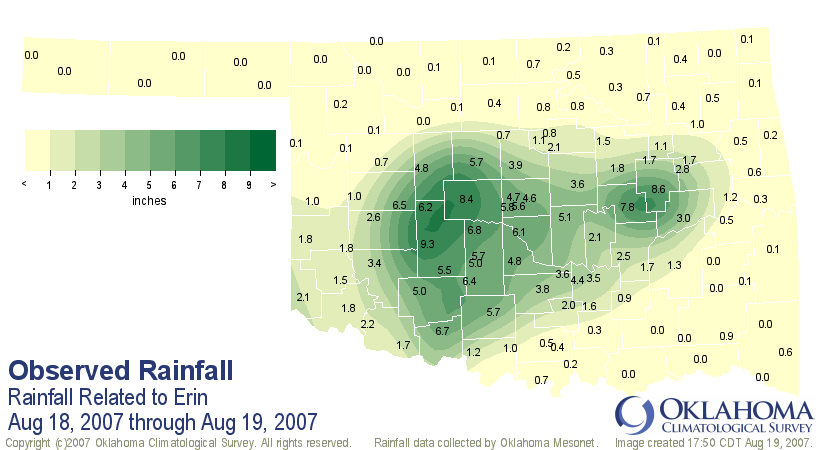
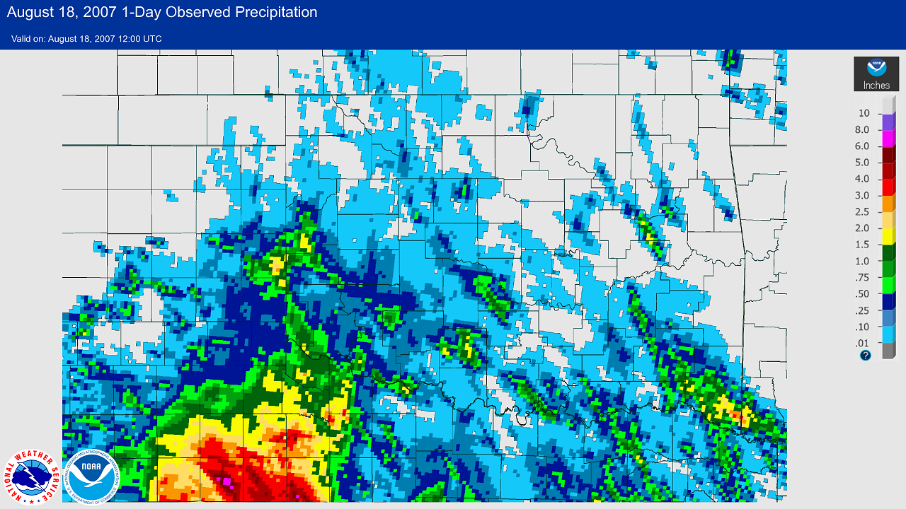
The following 3 graphics show the multi-sensor precipitation estimates (MPE) for the 24-hour periods ending at 7 AM CDT on August 18, 19, & 20, 2007. In the first precipitation map, rainfall amounts of 3-6+ inches can be seen in and near the western north Texas counties in the NWS Norman forecast area. This rainfall was produced by the remnants of Tropical Storm Erin and occurred during the 24-hour period ending at 7 AM CDT on August 18, 2007.
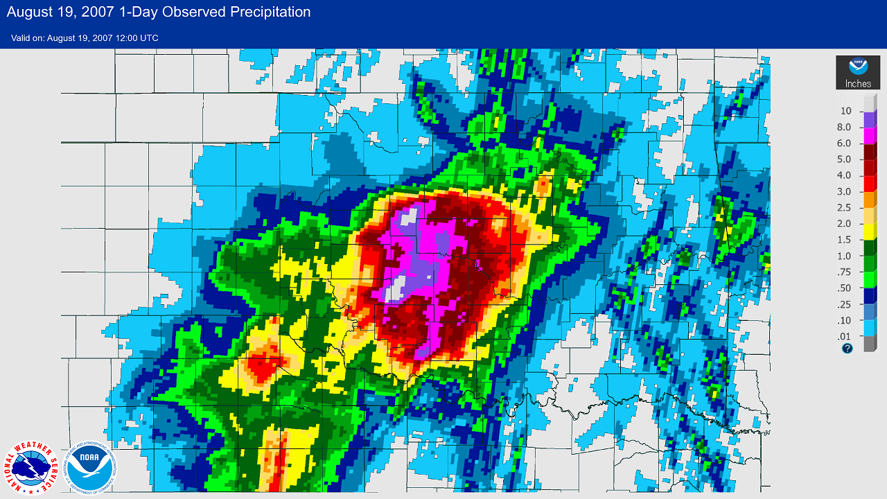
The second precipitation map shows where the remnants of Tropical Storm Erin intensified to tropical storm levels during the early morning hours of August 19, 2007 in western and central Oklahoma, and produced heavy rainfall totals of 5-11+ inches in that area for the 24-hour ending at 7 AM CDT on August 19, 2007
The third precipitation map shows heavy rainfall amounts of 4 to 10+ inches in east central Oklahoma as the remnants of Tropical Storm Erin continued eastward through and away from the NWS Norman forecast area during the late morning and afternoon hours of August 19, 2007. The map depicts 24-hour rainfall totals ending at 7 AM CDT on August 20, 2007.
 24-hour Multisensor Precipitation Estimates (MPE) ending at 7 AM CDT on August 19, 2007
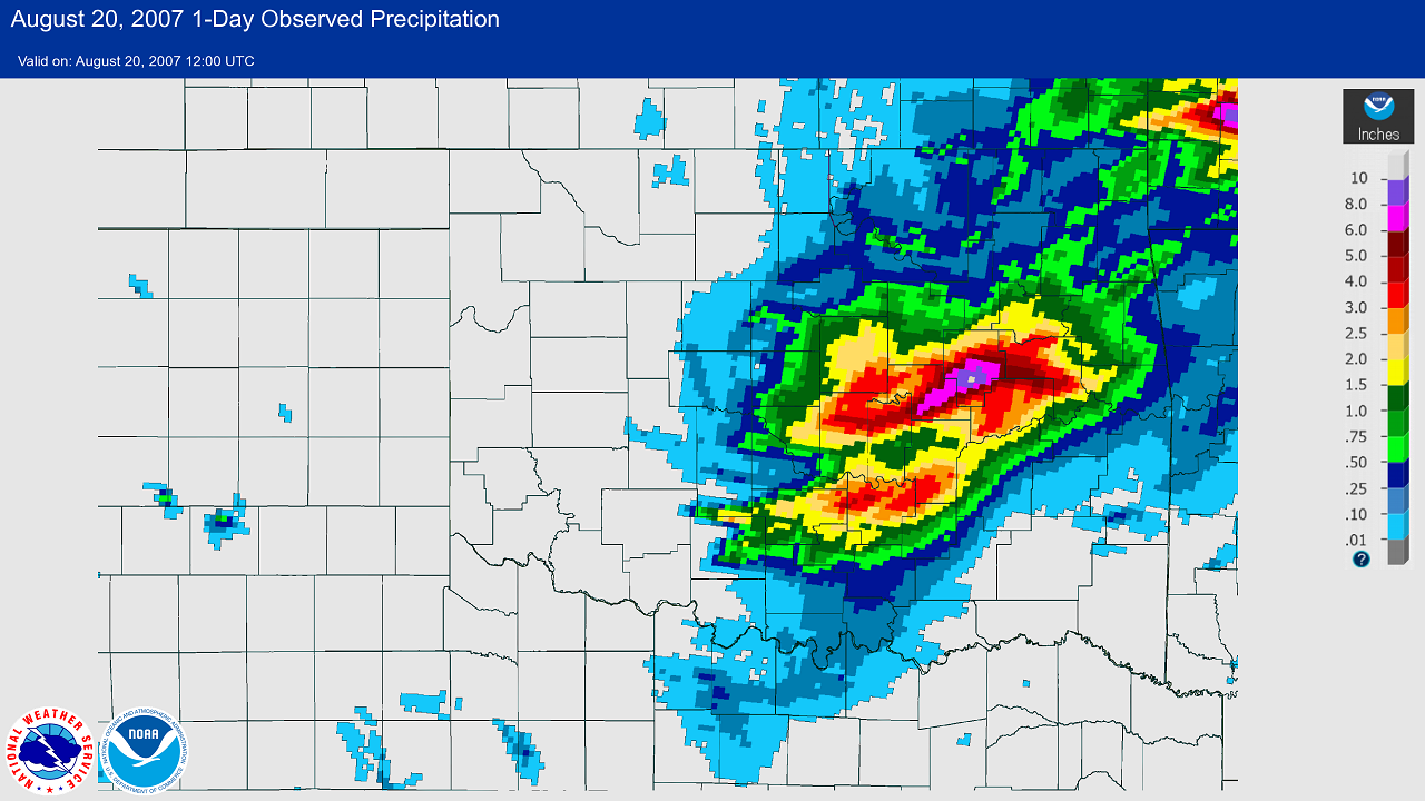 24-hour Multisensor Precipitation Estimates (MPE) ending at 7 AM CDT on August 20, 2007
| ID | Location | Type | County | State | Latitude | Longitude | Total |
|---|---|---|---|---|---|---|---|
| CRSO2 | Cherokee Mesonet | Mesonet | Alfalfa | OK | 36.748 | -98.363 | 0.09 |
| CHRO2 | Cherokee 4W | COOP | Alfalfa | OK | 36.767 | -98.424 | 0.03 |
| GSDO2 | Great Salt Plains Dam | COOP | Alfalfa | OK | 36.743 | -98.133 | 0.75 |
| HELO2 | Helena 1 SSE | COOP | Alfalfa | OK | 36.538 | -98.266 | 0.04 |
| GSPO2 | Great Salt Plains Lake | GOES | Alfalfa | OK | 36.744 | -98.136 | 0.66 |
| CRMO2 | Carmen | LARC | Alfalfa | OK | 36.583 | -98.450 | 0.05 |
| ATOO2 | Atoka | COOP | Atoka | OK | 34.398 | -96.140 | 0.08 |
| CANO2 | Caney 1 E | COOP | Atoka | OK | 34.230 | -96.195 | 0.23 |
| DAIO2 | Daisy 4 ENE | COOP | Atoka | OK | 34.544 | -95.676 | 0.32 |
| MGDO2 | McGee Creek Dam | COOP | Atoka | OK | 34.310 | -95.867 | 0.65 |
| AQR | Atoka Municipal Airport | AWOS | Atoka | OK | 34.398 | -96.148 | 0.03 |
| MGCO2 | McGee Creek Lake | GOES | Atoka | OK | 34.314 | -95.875 | 0.48 |
| LNSO2 | Lane Mesonet | Mesonet | Atoka | OK | 34.309 | -95.997 | 0.17 |
| OK-BC-1 | Sweetwater 5.9 S | CoCoRaHS | Beckham | OK | 35.337 | -99.938 | 1.52 |
| ERIO2 | Erick | COOP | Beckham | OK | 35.216 | -99.863 | 2.05 |
| MRVO2 | Moravia 2 NNE | COOP | Beckham | OK | 35.146 | -99.496 | 1.53 |
| RETO2 | Retrop | COOP | Beckham | OK | 35.158 | -99.366 | 2.60 |
| SARO2 | Sayre | COOP | Beckham | OK | 35.306 | -99.627 | 2.61 |
| SWEO2 | Sweetwater | COOP | Beckham | OK | 35.422 | -99.905 | 1.95 |
| ELCO2 | Elk City 4 W | GOES | Beckham | OK | 35.393 | -99.506 | 1.83 |
| CARO2 | Carter 3 S | GOES | Beckham | OK | 35.168 | -99.507 | 2.02 |
| ELCO2 | Elk City Weather Station | GOES | Beckham | OK | 35.427 | -99.395 | 0.86 |
| SAYO2 | Sayre 2 SE | GOES | Beckham | OK | 35.285 | -99.622 | 2.09 |
| SWTO2 | Sweetwater 3 W | GOES | Beckham | OK | 35.422 | -99.969 | 2.21 |
| EKSO2 | Erick Mesonet | Mesonet | Beckham | OK | 35.205 | -99.803 | 1.94 |
| OK-BL-1 | Geary 9.8 WNW | CoCoRaHS | Blaine | OK | 35.685 | -98.474 | 11.03 |
| GEAO2 | Geary | COOP | Blaine | OK | 35.631 | -98.322 | 10.53 |
| WTNO2 | Watonga | COOP | Blaine | OK | 35.858 | -98.414 | 9.11 |
| WATO2 | Watonga 2 S | GOES | Blaine | OK | 35.812 | -98.421 | 7.65 |
| WNSO2 | Watonga Mesonet | Mesonet | Blaine | OK | 35.842 | -98.526 | 4.83 |
| BOKO2 | Bokchito | COOP | Bryan | OK | 34.016 | -96.134 | 0.60 |
| DURO2 | Durant | COOP | Bryan | OK | 34.000 | -96.369 | 0.00 |
| KDUA | Durant, Eaker Field | AWOS | Bryan | OK | 33.940 | -96.395 | 0.42 |
| BLUO2 | Blue 1 W | GOES | Bryan | OK | 33.997 | -96.241 | 0.40 |
| BLUO2 | Blue 1 W | GOES | Bryan | OK | 33.998 | -96.240 | 0.40 |
| DTSO2 | Durant Mesonet | Mesonet | Bryan | OK | 33.921 | -96.320 | 0.01 |
| ANAO2 | Anadarko 3 E | COOP | Caddo | OK | 35.062 | -98.199 | 7.07 |
| APAO2 | Apache | COOP | Caddo | OK | 34.888 | -98.360 | 4.78 |
| LKBO2 | Lookeba 1 N | COOP | Caddo | OK | 35.374 | -98.377 | 8.52 |
| AWCO2 | Albert 3 W | GOES | Caddo | OK | 35.233 | -98.466 | 7.85 |
| CAGO2 | Carnegie 5 NE | GOES | Caddo | OK | 35.118 | -98.564 | 9.65 |
| CCWO2 | Cordell 9 E | GOES | Caddo | OK | 35.291 | -98.836 | 2.72 |
| EKCO2 | Eakly 2 SE | GOES | Caddo | OK | 35.291 | -98.529 | 7.34 |
| EAKO2 | Eakly 2 SW | GOES | Caddo | OK | 35.291 | -98.594 | 5.39 |
| FTCO2 | Fort Cobb Reservoir | GOES | Caddo | OK | 35.158 | -98.456 | 6.26 |
| HLCO2 | Sickles 4 WNW | GOES | Caddo | OK | 35.392 | -98.518 | 5.95 |
| APSO2 | Apache Mesonet | Mesonet | Caddo | OK | 34.914 | -98.292 | 5.53 |
| FCSO2 | Fort Cobb Mesonet | Mesonet | Caddo | OK | 35.149 | -98.466 | 9.35 |
| HYSO2 | Fort Cobb Micronet Station F101 | Micronet | Caddo | OK | 35.455 | -98.606 | 7.56 |
| HDSO2 | Fort Cobb Micronet Station F102 | Micronet | Caddo | OK | 35.450 | -98.544 | 6.21 |
| EASO2 | Fort Cobb Micronet Station F105 | Micronet | Caddo | OK | 35.407 | -98.571 | 6.98 |
| EBSO2 | Fort Cobb Micronet Station F106 | Micronet | Caddo | OK | 35.392 | -98.514 | 8.02 |
| ECSO2 | Fort Cobb Micronet Station F107 | Micronet | Caddo | OK | 35.376 | -98.465 | 8.12 |
| EDSO2 | Fort Cobb Micronet Station F108 | Micronet | Caddo | OK | 35.361 | -98.571 | 6.88 |
| EESO2 | Fort Cobb Micronet Station F109 | Micronet | Caddo | OK | 35.312 | -98.568 | 6.60 |
| LKSO2 | Fort Cobb Micronet Station F111 | Micronet | Caddo | OK | 35.334 | -98.438 | 8.05 |
| EGSO2 | Fort Cobb Micronet Station F112 | Micronet | Caddo | OK | 35.305 | -98.491 | 7.49 |
| ABSO2 | Fort Cobb Micronet Station F114 | Micronet | Caddo | OK | 35.283 | -98.437 | 8.31 |
| AFSO2 | Fort Cobb Micronet Station F115 | Micronet | Caddo | OK | 35.229 | -98.606 | 6.28 |
| SBSO2 | Little Washita Micronet Station A131 | Micronet | Caddo | OK | 34.950 | -98.234 | 6.14 |
| CSSO2 | Little Washita Micronet Station A132 | Micronet | Caddo | OK | 34.943 | -98.182 | 7.43 |
| COSO2 | Little Washita Micronet Station A133 | Micronet | Caddo | OK | 34.949 | -98.128 | 7.59 |
| CFSO2 | Little Washita Micronet Station A148 | Micronet | Caddo | OK | 34.899 | -98.128 | 6.40 |
| CJSO2 | Little Washita Micronet Station A149 | Micronet | Caddo | OK | 34.898 | -98.181 | 6.22 |
| CQSO2 | Little Washita Micronet Station A150 | Micronet | Caddo | OK | 34.906 | -98.251 | 5.66 |
| FLSO2 | Little Washita Micronet Station A152 | Micronet | Caddo | OK | 34.861 | -98.251 | 5.37 |
| CVSO2 | Little Washita Micronet Station A153 | Micronet | Caddo | OK | 34.855 | -98.200 | 5.53 |
| CISO2 | Little Washita Micronet Station A154 | Micronet | Caddo | OK | 34.855 | -98.137 | 5.90 |
| OK-CN-1 | Mustang 0.2 SE | CoCoRaHS | Canadian | OK | 35.391 | -97.721 | 6.75 |
| OK-CN-2 | Mustang 2.1 WNW | CoCoRaHS | Canadian | OK | 35.404 | -97.757 | 6.49 |
| OK-CN-7 | Piedmont 3.2 ESE | CoCoRaHS | Canadian | OK | 35.649 | -97.706 | 6.84 |
| PIEO2 | Piedmont 3 N | COOP | Canadian | OK | 35.691 | -97.745 | 6.61 |
| UNCO2 | Union City 3 SE | COOP | Canadian | OK | 35.367 | -97.887 | 5.68 |
| ERSO2 | El Reno Mesonet | Mesonet | Canadian | OK | 35.549 | -98.037 | 8.57 |
| ARMO2 | Ardmore | COOP | Carter | OK | 34.177 | -97.162 | 0.48 |
| HLDO2 | Healdton 3 E | COOP | Carter | OK | 34.233 | -97.420 | 0.67 |
| DURO2 | Dickson 3 N | GOES | Carter | OK | 34.233 | -96.976 | 0.35 |
| ARSO2 | Ardmore Mesonet | Mesonet | Carter | OK | 34.193 | -97.086 | 0.46 |
| LGSO2 | Newport Mesonet | Mesonet | Carter | OK | 34.228 | -97.201 | 0.71 |
| OK-CV-4 | Hall Park 2.4 WNW | CoCoRaHS | Cleveland | OK | 35.256 | -97.445 | 6.16 |
| OK-CV-10 | Hall Park 2.7 S | CoCoRaHS | Cleveland | OK | 35.201 | -97.404 | 8.10 |
| OK-CV-1 | Hall Park 4.1 SW | CoCoRaHS | Cleveland | OK | 35.193 | -97.452 | 7.05 |
| OK-CV-3 | Hall Park 4.7 W | CoCoRaHS | Cleveland | OK | 35.240 | -97.490 | 6.44 |
| OK-CV-7 | Hall Park 5.3 W | CoCoRaHS | Cleveland | OK | 35.249 | -97.500 | 6.08 |
| OK-CV-43 | Moore 0.5 NE | CoCoRaHS | Cleveland | OK | 35.335 | -97.470 | 5.69 |
| OK-CV-28 | Moore 0.9 N | CoCoRaHS | Cleveland | OK | 35.343 | -97.475 | 3.31 |
| OK-CV_8 | Moore 5.2 SSW | CoCoRaHS | Cleveland | OK | 35.257 | -97.497 | 5.93 |
| OK-CV-39 | Newcastle 5.1 ESE | CoCoRaHS | Cleveland | OK | 35.220 | -97.516 | 6.24 |
| OK-CV-16 | Noble 1.5 WNW | CoCoRaHS | Cleveland | OK | 35.150 | -97.396 | 7.31 |
| OK-CV-13 | Noble 3.1 NNW | CoCoRaHS | Cleveland | OK | 35.178 | -97.402 | 8.01 |
| OK-CV-17 | Noble 3.3 SE | CoCoRaHS | Cleveland | OK | 35.104 | -97.336 | 5.13 |
| OK-CV-21 | Noble 3.7 NW | CoCoRaHS | Cleveland | OK | 35.172 | -97.426 | 7.75 |
| OK-CV-44 | Norman 1.5 W | CoCoRaHS | Cleveland | OK | 35.219 | -97.466 | 5.41 |
| OK-CV-32 | Norman 2.1 SE | CoCoRaHS | Cleveland | OK | 35.198 | -97.418 | 8.20 |
| OK-CV-40 | Norman 2.2 ESE | CoCoRaHS | Cleveland | OK | 35.214 | -97.401 | 6.66 |
| OK-CV-2 | Norman 2.4 NNE | CoCoRaHS | Cleveland | OK | 35.256 | -97.428 | 6.35 |
| OK-CV-45 | Norman 2.7 SW | CoCoRaHS | Cleveland | OK | 35.194 | -97.471 | 6.80 |
| OK-CV-12 | Norman 3.1 WNW | CoCoRaHS | Cleveland | OK | 35.239 | -97.490 | 6.51 |
| OK-CV-25 | Norman 3.9 SE | CoCoRaHS | Cleveland | OK | 35.196 | -97.377 | 8.54 |
| OK-CV-46 | Norman 4.8 ESE | CoCoRaHS | Cleveland | OK | 35.195 | -97.360 | 7.31 |
| OK-CV-29 | Norman 6.3 E | CoCoRaHS | Cleveland | OK | 35.222 | -97.327 | 7.98 |
| OK-CV-6 | Norman 7.9 ESE | CoCoRaHS | Cleveland | OK | 35.208 | -97.300 | 8.80 |
| OK-CV-9 | Norman 8.4 SE | CoCoRaHS | Cleveland | OK | 35.193 | -97.295 | 7.66 |
| OK-CV-34 | Norman 9.2 E | CoCoRaHS | Cleveland | OK | 35.229 | -97.277 | 5.39 |
| NMNO2 | Norman 3SSE | COOP | Cleveland | OK | 35.181 | -97.438 | 7.77 |
| STEO2 | Stella | COOP | Cleveland | OK | 35.320 | -97.212 | 5.20 |
| NRSO2 | Norman Mesonet | Mesonet | Cleveland | OK | 35.236 | -97.465 | 6.08 |
| CENO2 | Chattanooga | COOP | Coal | OK | 34.601 | -96.313 | 0.85 |
| LEHO2 | Lehigh 4 SW | COOP | Coal | OK | 34.434 | -96.272 | 0.15 |
| CNSO2 | Centrahoma Mesonet | Mesonet | Coal | OK | 34.609 | -96.333 | 0.92 |
| CHAO2 | Chattanooga | COOP | Comanche | OK | 34.421 | -98.648 | 5.11 |
| LAWO2 | Lawton | COOP | Comanche | OK | 34.610 | -98.457 | 4.34 |
| WMRO2 | Wichita Mountain WLR | COOP | Comanche | OK | 34.733 | -98.712 | 8.60 |
| LAW | Lawton/Fort Sill Regional Airport | ASOS | Comanche | OK | 34.568 | -98.417 | 4.44 |
| LWSO2 | Medicine Park Mesonet | Mesonet | Comanche | OK | 34.749 | -98.569 | 5.28 |
| WMRO2 | Wichita Mountains RAWS | RAWS | Comanche | OK | 34.774 | -98.746 | 6.44 |
| DCNO2 | Duncan 10 W | COOP | Cotton | OK | 34.493 | -98.142 | 8.05 |
| RANO2 | Randlett 9 E | COOP | Cotton | OK | 34.158 | -98.311 | 3.15 |
| WALO2 | Walters | COOP | Cotton | OK | 34.360 | -98.301 | 0.85 |
| BKBT2 | Burkburnett 3 NE | GOES | Cotton | OK | 34.110 | -98.531 | 2.75 |
| WLTO2 | Walters 2 ENE | GOES | Cotton | OK | 34.362 | -98.282 | 8.37 |
| WTSO2 | Walters Mesonet | Mesonet | Cotton | OK | 34.365 | -98.320 | 6.66 |
| WEAO2 | Weatherford | COOP | Custer | OK | 35.520 | -98.699 | 6.49 |
| CLK | Clinton Regional Airport | AWOS | Custer | OK | 35.538 | -98.933 | 6.50 |
| CLIO2 | Clinton 1 N | GOES | Custer | OK | 35.531 | -98.967 | 5.44 |
| FBFO2 | Foss 6 N | GOES | Custer | OK | 35.539 | -99.169 | 1.85 |
| HMMO2 | Hammon 4 ENE | GOES | Custer | OK | 35.656 | -99.306 | 0.44 |
| BTSO2 | Butler Mesonet | Mesonet | Custer | OK | 35.592 | -99.271 | 1.01 |
| WXSO2 | Weatherford Mesonet | Mesonet | Custer | OK | 35.580 | -98.775 | 6.54 |
| LEEO2 | Leedey | COOP | Dewey | OK | 35.863 | -99.343 | 0.66 |
| TLGO2 | Taloga | COOP | Dewey | OK | 36.041 | -98.962 | 0.28 |
| CMSO2 | Camargo Mesonet | Mesonet | Dewey | OK | 36.029 | -99.347 | 0.11 |
| PMSO2 | Putnam Mesonet | Mesonet | Dewey | OK | 35.899 | -98.960 | 0.66 |
| GAG | Gage Airport | ASOS | Ellis | OK | 36.297 | -99.769 | 0.71 |
| ATSO2 | Arnett Mesonet | Mesonet | Ellis | OK | 36.072 | -99.903 | 0.07 |
| OK-GD-5 | Covington 1.8 N | CoCoRaHS | Garfield | OK | 36.333 | -97.586 | 0.73 |
| ENIO2 | Enid | COOP | Garfield | OK | 36.419 | -97.875 | 0.26 |
| END | Vance Air Force Base | ASOS | Garfield | OK | 36.339 | -97.917 | 0.39 |
| WDG | Enid/Woodring Regional Airport | AWOS | Garfield | OK | 36.379 | -97.791 | 0.27 |
| ESCO2 | Enid 5 ENE | GOES | Garfield | OK | 36.376 | -97.800 | 0.47 |
| ENSO2 | Breckinridge Mesonet | Mesonet | Garfield | OK | 36.412 | -97.694 | 0.36 |
| ELMO2 | Elmore City 3 SW | COOP | Garvin | OK | 34.610 | -97.422 | 3.78 |
| HENO2 | Hennepin 5 N | COOP | Garvin | OK | 34.580 | -97.351 | 2.25 |
| LINO2 | Lindsay 2 W | COOP | Garvin | OK | 34.826 | -97.639 | 0.51 |
| PVJ | Pauls Valley Municipal Airport | AWOS | Garvin | OK | 34.711 | -97.223 | 3.23 |
| PAUO2 | Pauls Valley 4 WSW | COOP | Garvin | OK | 34.725 | -97.281 | 4.56 |
| HVRO2 | Hoover 2 N | GOES | Garvin | OK | 34.541 | -97.247 | 3.64 |
| SFSO2 | Byars Mesonet | Mesonet | Garvin | OK | 34.850 | -97.003 | 3.63 |
| PVSO2 | Pauls Valley Mesonet | Mesonet | Garvin | OK | 34.716 | -97.292 | 3.83 |
| OK-GY-1 | Blanchard 1.8 SW | CoCoRaHS | Grady | OK | 35.129 | -97.683 | 6.53 |
| OK-GY-3 | Chickasha 1.8 SSE | CoCoRaHS | Grady | OK | 35.015 | -97.943 | 6.33 |
| CHKO2 | Chickasha Exp. Station | COOP | Grady | OK | 35.049 | -97.916 | 6.18 |
| COXO2 | Cox City 2 NE | COOP | Grady | OK | 34.742 | -97.704 | 7.45 |
| ALXO2 | Alex 1 N | GOES | Grady | OK | 34.926 | -97.775 | 5.28 |
| ACSO2 | Acme Mesonet | Mesonet | Grady | OK | 34.808 | -98.023 | 6.46 |
| CCSO2 | Chickasha Mesonet | Mesonet | Grady | OK | 35.032 | -97.915 | 5.70 |
| MOSO2 | Minco Mesonet | Mesonet | Grady | OK | 35.272 | -97.956 | 7.11 |
| NNSO2 | Ninnekah Mesonet | Mesonet | Grady | OK | 34.968 | -97.952 | 5.07 |
| NHSO2 | Little Washita Micronet Station A121 | Micronet | Grady | OK | 34.959 | -97.899 | 5.38 |
| NMSO2 | Little Washita Micronet Station A124 | Micronet | Grady | OK | 34.973 | -98.058 | 6.96 |
| CGSO2 | Little Washita Micronet Station A134 | Micronet | Grady | OK | 34.937 | -98.075 | 5.79 |
| NISO2 | Little Washita Micronet Station A135 | Micronet | Grady | OK | 34.927 | -98.020 | 4.86 |
| NASO2 | Little Washita Micronet Station A136 | Micronet | Grady | OK | 34.928 | -97.966 | 4.36 |
| AGSO2 | Little Washita Micronet Station A144 | Micronet | Grady | OK | 34.879 | -97.917 | 5.97 |
| AMSO2 | Little Washita Micronet Station A146 | Micronet | Grady | OK | 34.885 | -98.023 | 5.38 |
| AASO2 | Little Washita Micronet Station A156 | Micronet | Grady | OK | 34.843 | -97.958 | 6.04 |
| RHSO2 | Little Washita Micronet Station A159 | Micronet | Grady | OK | 34.797 | -97.993 | 6.63 |
| RGSO2 | Little Washita Micronet Station A182 | Micronet | Grady | OK | 34.845 | -98.073 | 6.44 |
| LWAO2 | Little Washita SCAN Site | SCAN | Grady | OK | 34.950 | -97.980 | 5.90 |
| OK-GT-1 | Hunter 6.0 NNE | CoCoRaHS | Grant | OK | 36.636 | -97.604 | 0.83 |
| JEFO2 | Jefferson 3SE | COOP | Grant | OK | 36.686 | -97.749 | 0.16 |
| LAMO2 | Lamont | COOP | Grant | OK | 36.688 | -97.557 | 0.84 |
| MEDO2 | Medford | COOP | Grant | OK | 36.796 | -97.736 | 0.06 |
| MFSO2 | Medford Mesonet | Mesonet | Grant | OK | 36.792 | -97.746 | 0.09 |
| MGUO2 | Mangum | COOP | Greer | OK | 34.891 | -99.502 | 1.11 |
| WILO2 | Willow | COOP | Greer | OK | 35.052 | -99.512 | 1.82 |
| GNTO2 | Granite 5 S | GOES | Greer | OK | 34.889 | -99.378 | 0.41 |
| MGMO2 | Mangum 1 S | GOES | Greer | OK | 34.858 | -99.508 | 0.69 |
| MNSO2 | Mangum Mesonet | Mesonet | Greer | OK | 34.836 | -99.424 | 1.61 |
| HOSO2 | Hollis 5E | COOP | Harmon | OK | 34.681 | -99.813 | 2.28 |
| VINO2 | Vinson | COOP | Harmon | OK | 34.900 | -99.861 | 1.97 |
| CRLO2 | Vinson 8 NNW | GOES | Harmon | OK | 35.012 | -99.903 | 1.72 |
| HISO2 | Hollis Mesonet | Mesonet | Harmon | OK | 34.684 | -99.833 | 2.28 |
| BUFO2 | Buffalo 2 SSW | COOP | Harper | OK | 36.800 | -99.640 | 0.15 |
| LAVO2 | Laverne | COOP | Harper | OK | 36.699 | -99.897 | 0.07 |
| BFSO2 | Buffalo Mesonet | Mesonet | Harper | OK | 36.831 | -99.641 | 0.03 |
| CALO2 | Calvin | COOP | Hughes | OK | 34.964 | -96.249 | 3.00 |
| HDNO2 | Holdenville 2SSE | COOP | Hughes | OK | 35.057 | -96.386 | 1.48 |
| WETO2 | Wetumka 3 NE | GOES | Hughes | OK | 35.266 | -96.206 | 2.10 |
| HLSO2 | Calvin Mesonet | Mesonet | Hughes | OK | 34.992 | -96.334 | 2.49 |
| ALGO2 | Altus Irig. Res. Station | COOP | Jackson | OK | 34.590 | -99.334 | 1.98 |
| HEDO2 | Headrick | COOP | Jackson | OK | 34.629 | -99.139 | 2.94 |
| LTS | Altus Air Force Base | ASOS | Jackson | OK | 34.667 | -99.267 | 1.98 |
| AXS | Altus/Quartz Mountain Regional Airport | AWOS | Jackson | OK | 34.699 | -99.338 | 1.49 |
| HEAO2 | Headrick 3 E | GOES | Jackson | OK | 34.638 | -99.103 | 2.68 |
| ELMO2 | Elmer | LARC | Jackson | OK | 34.479 | -99.352 | 2.14 |
| ALSO2 | Altus Mesonet | Mesonet | Jackson | OK | 34.587 | -99.338 | 1.93 |
| GRDO2 | Grady 2E | COOP | Jefferson | OK | 34.023 | -97.634 | 0.95 |
| WAKO2 | Waurika | COOP | Jefferson | OK | 34.175 | -97.996 | 1.25 |
| WRLO2 | Waurika Lake | GOES | Jefferson | OK | 34.233 | -98.048 | 1.62 |
| RNSO2 | Ringling Mesonet | Mesonet | Jefferson | OK | 34.194 | -97.588 | 1.00 |
| WRSO2 | Waurika Mesonet | Mesonet | Jefferson | OK | 34.168 | -97.988 | 1.25 |
| COLO2 | Coleman 4W | COOP | Johnston | OK | 34.276 | -96.495 | 0.00 |
| PONO2 | Pontotoc 1N | COOP | Johnston | OK | 34.505 | -96.622 | 0.00 |
| TISO2 | Tishomingo Natl. WLR | COOP | Johnston | OK | 34.207 | -96.642 | 0.00 |
| CNVO2 | Connerville 5 SSE | GOES | Johnston | OK | 34.383 | -96.600 | 0.37 |
| MCKO2 | Mill Creek 2 W | GOES | Johnston | OK | 34.405 | -96.863 | 0.66 |
| MCPO2 | Mill Creek 4 ENE | GOES | Johnston | OK | 34.420 | -96.759 | 0.69 |
| TSSO2 | Tishomingo Mesonet | Mesonet | Johnston | OK | 34.333 | -96.679 | 0.28 |
| OK-KY-3 | Lamont 5.7 ENE | CoCoRaHS | Kay | OK | 36.718 | -97.459 | 0.32 |
| OK-KY-4 | Tonkawa 0.4 SSW | CoCoRaHS | Kay | OK | 36.678 | -97.311 | 1.35 |
| BLAO2 | Blackwell 1SSW | COOP | Kay | OK | 36.784 | -97.290 | 1.15 |
| BRMO2 | Braman | COOP | Kay | OK | 36.922 | -97.336 | 0.26 |
| HRDO2 | Hardy 2SSW | COOP | Kay | OK | 36.938 | -96.821 | 0.14 |
| NWKO2 | Newkirk 5NE | COOP | Kay | OK | 36.942 | -97.006 | 0.73 |
| PNC | Ponca City Municipal AP | ASOS | Kay | OK | 36.737 | -97.102 | 0.21 |
| BLKO2 | Blackwell 1 NE | GOES | Kay | OK | 36.812 | -97.277 | 0.64 |
| HARO2 | Hardy 2 S | GOES | Kay | OK | 36.946 | -96.799 | 0.06 |
| TONO2 | Tonkawa 1 S | GOES | Kay | OK | 36.672 | -97.309 | 1.16 |
| BLSO2 | Blackwell Mesonet | Mesonet | Kay | OK | 36.754 | -97.255 | 0.65 |
| NKSO2 | Newkirk Mesonet | Mesonet | Kay | OK | 36.898 | -96.910 | 0.22 |
| HSYO2 | Hennessey 4 ESE | COOP | Kingfisher | OK | 36.094 | -97.835 | 0.79 |
| KINO2 | Kingfisher | COOP | Kingfisher | OK | 35.858 | -97.929 | 5.20 |
| OKAO2 | Okarche | COOP | Kingfisher | OK | 35.732 | -97.971 | 5.91 |
| DOVO2 | Dover 2 S | GOES | Kingfisher | OK | 35.952 | -97.914 | 4.58 |
| KFSO2 | Kingfisher Mesonet | Mesonet | Kingfisher | OK | 35.854 | -97.954 | 5.68 |
| ATUO2 | Altus Dam | COOP | Kiowa | OK | 34.885 | -99.296 | 2.34 |
| RSVO2 | Roosevelt | COOP | Kiowa | OK | 34.851 | -99.021 | 4.08 |
| MTVO2 | Sedan | COOP | Kiowa | OK | 34.969 | -98.760 | 8.84 |
| SNYO2 | Snyder | COOP | Kiowa | OK | 34.650 | -98.954 | 4.13 |
| HBR | Hobart Municipal Airport | ASOS | Kiowa | OK | 34.991 | -99.051 | 3.73 |
| SYDO2 | Snyder 3 SW | GOES | Kiowa | OK | 34.638 | -98.998 | 3.55 |
| ALTO2 | Altus-Lugert Lake | GOES | Kiowa | OK | 34.886 | -99.295 | 2.22 |
| HBSO2 | Hobart Mesonet | Mesonet | Kiowa | OK | 34.990 | -99.053 | 3.79 |
| CHNO2 | Chandler | COOP | Lincoln | OK | 35.706 | -96.880 | 6.94 |
| MKRO2 | Meeker 5 W | COOP | Lincoln | OK | 35.505 | -96.977 | 6.02 |
| PRGO2 | Prague 2W | COOP | Lincoln | OK | 35.488 | -96.730 | 5.58 |
| STRO2 | Stroud 3 N | COOP | Lincoln | OK | 35.798 | -96.666 | 0.80 |
| CHSO2 | Chandler Mesonet | Mesonet | Lincoln | OK | 35.653 | -96.804 | 3.59 |
| OK-LG-4 | Guthrie 4.9 SSE | CoCoRaHS | Logan | OK | 35.771 | -97.409 | 4.43 |
| CREO2 | Crescent 5WSW | COOP | Logan | OK | 35.927 | -97.674 | 4.12 |
| GUTO2 | Guthrie 5S | COOP | Logan | OK | 35.816 | -97.395 | 4.36 |
| MSHO2 | Marshall | COOP | Logan | OK | 36.152 | -97.623 | 0.65 |
| MULO2 | Mulhall 1 SE | COOP | Logan | OK | 36.048 | -97.390 | 1.11 |
| GOK | Guthrie Municipal AP | ASOS | Logan | OK | 35.852 | -97.414 | 3.24 |
| GTRO2 | Guthrie 3 N | GOES | Logan | OK | 35.921 | -97.426 | 3.53 |
| LVLO2 | Lovell 3 E | GOES | Logan | OK | 36.060 | -97.585 | 0.66 |
| SWDO2 | Seward 1 N | GOES | Logan | OK | 35.814 | -97.478 | 3.82 |
| GTSO2 | Guthrie Mesonet | Mesonet | Logan | OK | 35.849 | -97.480 | 3.92 |
| MSSO2 | Marshall Mesonet | Mesonet | Logan | OK | 36.117 | -97.607 | 0.70 |
| MRTO2 | Marietta 5SW | COOP | Love | OK | 33.876 | -97.164 | 0.20 |
| GSVT2 | Gainesville 7 N | GOES | Love | OK | 33.728 | -97.160 | 0.13 |
| BNSO2 | Burneyville Mesonet | Mesonet | Love | OK | 33.394 | -97.269 | 0.66 |
| LAHO2 | Lahoma Research Station | COOP | Major | OK | 36.390 | -98.106 | 0.09 |
| ORIO2 | Orienta 1SSW | COOP | Major | OK | 36.349 | -98.481 | 0.00 |
| LHMO2 | Lahoma 1 W Rain Gauge | GOES | Major | OK | 36.390 | -98.106 | 0.07 |
| SEIO2 | Seiling 3 N | GOES | Major | OK | 36.183 | -98.921 | 0.06 |
| FVSO2 | Fairview Mesonet | Mesonet | Major | OK | 36.264 | -98.498 | 0.11 |
| LHSO2 | Lahoma Mesonet | Mesonet | Major | OK | 36.384 | -98.111 | 0.09 |
| KNGO2 | Kingston 5 SSE | COOP | Marshall | OK | 33.930 | -96.696 | 0.29 |
| MADO2 | Madill | COOP | Marshall | OK | 34.092 | -96.771 | 0.29 |
| MDSO2 | Madill Mesonet | Mesonet | Marshall | OK | 34.036 | -96.944 | 0.38 |
| OK-MC-2 | Blanchard 2.1 ESE | CoCoRaHS | McClain | OK | 35.133 | -97.624 | 6.35 |
| OK-MC-1 | Wayne 3.5 E | CoCoRaHS | McClain | OK | 34.911 | -97.254 | 2.95 |
| BLNO2 | Blanchard 2 SSW | COOP | McClain | OK | 35.118 | -97.670 | 6.45 |
| PCSO2 | Washington Mesonet | Mesonet | McClain | OK | 34.982 | -97.521 | 5.86 |
| OK-MR-1 | Sulphur 2.5 WSW | CoCoRaHS | Murray | OK | 34.491 | -97.018 | 1.51 |
| SULO2 | Chickasaw NRA | COOP | Murray | OK | 34.497 | -96.971 | 1.52 |
| DVSO2 | Davis 5 SSW | GOES | Murray | OK | 34.432 | -97.147 | 1.38 |
| SLSO2 | Sulphur Mesonet | Mesonet | Murray | OK | 34.566 | -96.950 | 2.05 |
| OK-NB-1 | Billings 4.1 SSE | CoCoRaHS | Noble | OK | 36.475 | -97.422 | 0.31 |
| OK-NB-3 | Garber 7.9 ESE | CoCoRaHS | Noble | OK | 36.375 | -97.460 | 0.93 |
| OK-NB-2 | Lucien 6.6 N | CoCoRaHS | Noble | OK | 36.375 | -97.443 | 1.07 |
| BILO2 | Billings | COOP | Noble | OK | 36.530 | -97.447 | 0.28 |
| MORO2 | Morrison | COOP | Noble | OK | 36.295 | -97.020 | 1.03 |
| PRRO2 | Perry | COOP | Noble | OK | 36.289 | -97.290 | 2.01 |
| RDRO2 | Red Rock | COOP | Noble | OK | 36.461 | -97.180 | 0.51 |
| PYSO2 | Red Rock Mesonet | Mesonet | Noble | OK | 36.356 | -97.153 | 0.85 |
| OK-OK-5 | Bethany 0.7 SSW | CoCoRaHS | Oklahoma | OK | 35.496 | -97.647 | 6.34 |
| OK-OK-1 | Bethany 0.8 W | CoCoRaHS | Oklahoma | OK | 35.508 | -97.657 | 6.23 |
| OK-OK-3 | Edmond 1.6 W | CoCoRaHS | Oklahoma | OK | 35.673 | -97.441 | 6.07 |
| OK-OK-13 | Wiley Post 1.6 NNW | CoCoRaHS | Oklahoma | OK | 35.553 | -97.657 | 6.03 |
| EDMO2 | Edmond 5ESE | COOP | Oklahoma | OK | 35.613 | -97.386 | 5.79 |
| OKCO2 | Oklahoma City | COOP | Oklahoma | OK | 35.406 | -97.597 | 4.94 |
| PWA | Bethany/Wiley Post AP | ASOS | Oklahoma | OK | 35.534 | -97.647 | 4.65 |
| OKC | OKC/Will Rogers World AP | ASOS | Oklahoma | OK | 35.389 | -97.601 | 5.46 |
| TIK | Tinker Air Force Base | ASOS | Oklahoma | OK | 35.415 | -97.387 | 5.45 |
| OLBO2 | OKC 6 SSW | GOES | Oklahoma | OK | 35.479 | -97.663 | 5.82 |
| DRCO2 | Deer Creek | LARC | Oklahoma | OK | 35.683 | -97.583 | 5.98 |
| OESO2 | OKC East Mesonet | Mesonet | Oklahoma | OK | 35.472 | -97.464 | 5.59 |
| OCSO2 | OKC North Mesonet | Mesonet | Oklahoma | OK | 35.556 | -97.511 | 4.71 |
| OYSO2 | OKC West Mesonet | Mesonet | Oklahoma | OK | 35.471 | -97.582 | 5.78 |
| CUSO2 | Cushing | COOP | Payne | OK | 35.980 | -96.776 | 2.10 |
| INGO2 | Ingalls 1N | COOP | Payne | OK | 36.114 | -96.879 | 1.82 |
| PRNO2 | Perkins | COOP | Payne | OK | 35.974 | -97.027 | 2.78 |
| STWO2 | Stillwater 2 W | COOP | Payne | OK | 36.118 | -97.095 | 0.81 |
| CUH | Cushing Municipal Airport | AWOS | Payne | OK | 35.950 | -96.773 | 2.66 |
| SAFO2 | Stillwater 2 W CRN Site | CRN | Payne | OK | 36.118 | -97.091 | 0.99 |
| SEFO2 | Stillwater 5 WNW CRN Site | CRN | Payne | OK | 36.134 | -97.108 | 1.17 |
| MASO2 | Marena Mesonet | Mesonet | Payne | OK | 36.064 | -97.213 | 1.11 |
| PRSO2 | Perkins Mesonet | Mesonet | Payne | OK | 35.999 | -97.048 | 2.08 |
| SRSO2 | Stillwater Mesonet | Mesonet | Payne | OK | 36.121 | -97.096 | 0.79 |
| OK-PN-2 | Ada 6.8 NNE | CoCoRaHS | Pontotoc | OK | 34.871 | -96.625 | 3.47 |
| ADAO2 | Ada | COOP | Pontotoc | OK | 34.786 | -96.685 | 3.57 |
| FITO2 | Fittstown 2 E | GOES | Pontotoc | OK | 34.600 | -96.667 | 1.46 |
| ADSO2 | Ada Mesonet | Mesonet | Pontotoc | OK | 34.799 | -96.669 | 3.51 |
| FISO2 | Fittstown Mesonet | Mesonet | Pontotoc | OK | 34.552 | -96.718 | 1.66 |
| VASO2 | Vanoss Mesonet | Mesonet | Pontotoc | OK | 34.791 | -96.844 | 4.40 |
| OK-PT-1 | Shawnee 0.8 ESE | CoCoRaHS | Pottawatomie | OK | 35.361 | -96.955 | 6.19 |
| OK-PT-2 | Tecumseh 0.4 ESE | CoCoRaHS | Pottawatomie | OK | 35.261 | -96.927 | 6.46 |
| SHAO2 | Shawnee | COOP | Pottawatomie | OK | 35.355 | -96.920 | 7.11 |
| TECO2 | Tecumseh | COOP | Pottawatomie | OK | 35.259 | -96.918 | 5.52 |
| SNL | Shawnee Municipal Airport | AWOS | Pottawatomie | OK | 35.357 | -96.943 | 5.47 |
| SHSO2 | Shawnee Mesonet | Mesonet | Pottawatomie | OK | 35.365 | -96.948 | 5.15 |
| OK-RM-2 | Cheyenne 18.1 SW | CoCoRaHS | Roger Mills | OK | 35.861 | -99.782 | 0.68 |
| OK-RM-3 | Cheyenne 5.5 SSE | CoCoRaHS | Roger Mills | OK | 35.535 | -99.651 | 1.33 |
| OK-RM-1 | Hammon 0.1 S | CoCoRaHS | Roger Mills | OK | 35.631 | -99.384 | 0.81 |
| CHYO2 | Cheyenne 1 N | GOES | Roger Mills | OK | 35.627 | -99.669 | 0.92 |
| CYSO2 | Chyenne Mesonet | Mesonet | Roger Mills | OK | 35.546 | -99.728 | 1.43 |
| KONO2 | Konawa | COOP | Seminole | OK | 34.961 | -96.750 | 3.35 |
| SEMO2 | Seminole | COOP | Seminole | OK | 35.232 | -96.653 | 4.70 |
| WEWO2 | Wewoka 3 SW | COOP | Seminole | OK | 35.131 | -96.539 | 1.72 |
| SRE | Seminole Municipal Airport | AWOS | Seminole | OK | 35.275 | -96.675 | 7.65 |
| KCRO2 | Konowa 4 ESE | GOES | Seminole | OK | 34.933 | -96.683 | 1.84 |
| SMSO2 | Bowlegs Mesonet | Mesonet | Seminole | OK | 35.172 | -96.631 | 2.10 |
| CMNO2 | Comanche | COOP | Stephens | OK | 34.362 | -97.974 | 2.42 |
| DNCO2 | Duncan | COOP | Stephens | OK | 34.501 | -97.959 | 7.08 |
| LOCO2 | Loco | COOP | Stephens | OK | 34.328 | -97.679 | 2.90 |
| MLWO2 | Marlow 1 WSW | COOP | Stephens | OK | 34.637 | -97.979 | 6.32 |
| DUC | Duncan/Halliburton Field Airport | AWOS | Stephens | OK | 34.471 | -97.960 | 4.83 |
| DUNO2 | Duncan Airport | LARC | Stephens | OK | 34.483 | -97.958 | 6.20 |
| DNSO2 | Ketchum Ranch Mesonet | Mesonet | Stephens | OK | 34.529 | -97.765 | 6.24 |
| FRDO2 | Frederick | COOP | Tillman | OK | 34.386 | -99.020 | 1.89 |
| HEDO2 | Headrick 2 E | COOP | Tillman | OK | 34.638 | -99.104 | 0.50 |
| FDR | Frederick Municipal Airport | ASOS | Tillman | OK | 34.352 | -98.984 | 2.83 |
| GRSO2 | Grandfield Mesonet | Mesonet | Tillman | OK | 34.239 | -98.744 | 1.99 |
| TPSO2 | Tipton Mesonet | Mesonet | Tillman | OK | 34.440 | -99.138 | 2.82 |
| OK-WH-1 | Cordell 0.8 SW | CoCoRaHS | Washita | OK | 35.290 | -98.989 | 4.18 |
| CNYO2 | Colony | COOP | Washita | OK | 35.350 | -98.674 | 6.19 |
| CRDO2 | Cordell | COOP | Washita | OK | 35.301 | -98.996 | 3.95 |
| CSM | Clinton-Sherman Airport | ASOS | Washita | OK | 35.340 | -99.201 | 0.78 |
| BSSO2 | Bessie Mesonet | Mesonet | Washita | OK | 35.402 | -99.059 | 2.60 |
| RTSO2 | Retrop Mesonet | Mesonet | Washita | OK | 35.123 | -99.360 | 2.58 |
| CXSO2 | Fort Cobb Micronet Station F103 | Micronet | Washita | OK | 35.424 | -98.709 | 7.62 |
| CWSO2 | Fort Cobb Micronet Station F104 | Micronet | Washita | OK | 35.392 | -98.623 | 7.35 |
| NYSO2 | Fort Cobb Micronet Station F113 | Micronet | Washita | OK | 35.291 | -98.636 | 7.58 |
| ALVO2 | Alva 1W | COOP | Woods | OK | 36.801 | -98.688 | 0.00 |
| FREO2 | Freedom | COOP | Woods | OK | 36.765 | -99.113 | T |
| AVK | Alva Regional Airport | AWOS | Woods | OK | 36.773 | -98.670 | 0.00 |
| WAYO2 | Waynoka | COOP | Woods | OK | 36.576 | -98.880 | 0.05 |
| WANO2 | Waynoka 5 S | GOES | Woods | OK | 36.517 | -98.880 | 0.01 |
| AVAO2 | Alva 1 NE | GOES | Woods | OK | 36.815 | -98.648 | 0.01 |
| BFFO2 | Buffalo 17 E | GOES | Woods | OK | 36.852 | -99.315 | 0.00 |
| WANO2 | Waynoka 5 S | GOES | Woods | OK | 36.517 | -98.879 | 0.01 |
| AVSO2 | Alva Mesonet | Mesonet | Woods | OK | 36.708 | -98.710 | 0.03 |
| MYSO2 | May Ranch Mesonet | Mesonet | Woods | OK | 36.987 | -99.011 | 0.00 |
| FARO2 | Fargo 3ENE | COOP | Woodward | OK | 36.391 | -99.564 | 0.00 |
| FSYO2 | Fort Supply 3SE | COOP | Woodward | OK | 36.544 | -99.535 | 0.10 |
| MUTO2 | Mutual | COOP | Woodward | OK | 36.228 | -99.170 | 0.18 |
| VICO2 | Vici 1NNW | COOP | Woodward | OK | 36.166 | -99.304 | 0.34 |
| WOOO2 | Woodward | COOP | Woodward | OK | 36.441 | -99.382 | 0.13 |
| WWR | West Woodward Airport | AWOS | Woodward | OK | 36.438 | -99.523 | 0.05 |
| FWCO2 | Fort Supply 9 S | GOES | Woodward | OK | 36.449 | -99.589 | 0.00 |
| FSLO2 | Fort Supply Lake | GOES | Woodward | OK | 36.554 | -99.571 | 0.00 |
| FDSO2 | Freedom Mesonet | Mesonet | Woodward | OK | 36.726 | -99.142 | 0.01 |
| SESO2 | Seiling Mesonet | Mesonet | Woodward | OK | 36.190 | -99.040 | 0.15 |
| WWSO2 | Woodward Mesonet | Mesonet | Woodward | OK | 36.423 | -99.417 | 0.16 |
| ACIT2 | Archer City 2W | COOP | Archer | TX | 33.599 | -98.654 | 0.47 |
| SCOT2 | Scotland | COOP | Archer | TX | 33.663 | -98.470 | 0.04 |
| ALWT2 | Archer City 5 N | GOES | Archer | TX | 33.663 | -98.613 | 0.49 |
| ARHT2 | Lake Kickapoo | GOES | Archer | TX | 33.663 | -98.779 | 0.88 |
| SMUT2 | Lake Kemp | COOP | Baylor | TX | 33.754 | -99.144 | 1.67 |
| MCBT2 | Miller Creek RAWS | RAWS | Baylor | TX | 33.414 | -99.401 | 1.14 |
| CIET2 | Charlie | COOP | Clay | TX | 34.097 | -98.316 | 1.42 |
| HTAT2 | Henrietta 3 W | GOES | Clay | TX | 33.827 | -98.240 | 0.23 |
| ARRT2 | Lake Arrowhead | GOES | Clay | TX | 33.764 | -98.371 | 0.06 |
| CWLT2 | Crowell | COOP | Foard | TX | 33.990 | -99.730 | 2.49 |
| CBRT2 | Copper Breaks State Park | COOP | Hardeman | TX | 34.112 | -99.743 | 1.39 |
| QNHT2 | Quanah 2 SW | COOP | Hardeman | TX | 34.276 | -99.758 | 4.00 |
| TSCT2 | Truscott 3 W | COOP | Knox | TX | 33.757 | -99.862 | 3.73 |
| SPS | Wichita Falls Municipal AP | ASOS | Wichita | TX | 33.979 | -98.493 | 1.50 |
| F05 | Vernon/Wilbarger County Airport | AWOS | Wilbarger | TX | 33.663 | -98.613 | 1.64 |
| TX-WT-5 | Wichita Falls 4.4 N | CoCoRaHS | Wichita | TX | 33.962 | -98.515 | 2.55 |
| BBUT2 | Burkburnett | COOP | Wichita | TX | 34.091 | -98.586 | 2.54 |
| BKBT2 | Burkburnett 2 NE | GOES | Wichita | TX | 34.106 | -98.535 | 1.03 |
| WICT2 | Wichita Falls 2 W | GOES | Wichita | TX | 33.909 | -98.533 | 0.67 |
| VNNT2 | Vernon | COOP | Wilbarger | TX | 34.152 | -99.325 | 2.90 |

