
Heat expands across the Desert Southwest, Plains, Mississippi Valley and Midwest into Monday. Fire weather concerns continue for portions of the Intermountain West. Active monsoonal moisture fuels thunderstorms over the Southwest with possible flash flooding. Tropical cyclone Fausto in the Pacific, should weaken as it approaches Hawaii; Dangerous surf, swells and rip currents are expected. Read More >
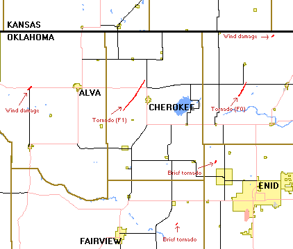
During the early morning hours of Monday, April 5, 1999 severe thunderstorms occurred over northwest and north central Oklahoma. Although there were many storms which occurred over the affected area between 1 AM CDT and 7 AM CDT, this post event summary report will concentrate on surveyed damage in Alfalfa and Grant Counties. One severe thunderstorm produced a sporadic path of damage across Alfalfa County including an F1 tornado from 6 miles west-southwest of Cherokee to 4.5 miles north of Cherokee. A separate storm produced a sporadic damage path from northeast Major County, across northwest Garfield County and across Grant County including an F0 tornado from 8 miles south-southwest of Wakita to 5 miles south of Wakita. A damage survey of these areas was conducted on Tuesday, April 6 by Norman National Weather Service meteorologist Dan Miller. Additional storm damage was observed in the area during the same time, but was not surveyed. A composite of the damage is shown in Figure 1 below.
A long line of thunderstorms moved east across most of western and central Oklahoma during the early morning of the 5th resulting in widespread straight-line damage and 5 tornadoes. Severe thunderstorms first developed in Magnum in Greer County where large tree limbs were blown down. In Woods County trees were downed 12 miles west of Alva near the intersection of Highway 64 and Highway 14.
In addition, power poles were snapped; house roofs and barns were damaged, and sheds were blown over. Power lines were also downed 7 miles west of Alva. In Washita County many house roofs were damaged in Dill City, and power lines were downed 5 miles southwest of Dill City. In Woodward County large tree limbs were downed in Belva, while in Mooreland a camper trailer was destroyed; fences and tree limbs were blown down, and numerous vehicles were damaged.
A survey conducted by the National Weather Service concluded that an F1 tornado touched down 6 miles west-southwest of Cherokee in Alfalfa County and tracked northeast for 7 miles before dissipating about 4 miles north of Cherokee. Two hay storage barns and another storage barn at a feedlot were destroyed, and a large irrigation system was destroyed. Also in Alfalfa County a haybarn was destroyed in Ingersoll; the roof was ripped off of a boat house, and another house received minor roof damage. Large power poles were blown down 5 miles northeast of Cherokee, and a barn was blown down in Amorita, also in Alfalfa County.
Another tornado was confirmed by a National Weather Service survey 4 miles north-northeast of Ames in Major County. This tornado, rated an F0, touched down in an open field with no known damage. The same thunderstorm that produced this tornado was also responsible for straight-line winds which blew a moving vehicle off the road 4 miles north of Ames.
A tornado also developed 2 miles north of Carrier in Garfield County, but no damage (F0) was observed as it touched down briefly in an open field.
Another tornado, the third of the day, touched down about 8 miles south-southwest of Wakita in Garfield County and tracked northeast to about 5 miles south of Wakita. One sheet metal/wood frame hay storage barn was destroyed, and another was damaged. A truck was damaged, and tree limbs were blown down. The weak nature of the structures damaged or destroyed by this tornado warranted an F0 intensity rating.
In addition to the tornado damage in Garfield County, straight-line wind damage was observed 2 miles north of Carrier where road signs were blown over, 7 miles south of Wakita where a shed was destroyed; a barn was blown over; a truck was damaged, and a few homes suffered roof and window damage, and 12 miles northwest of Medford where a semi was blown over, while in Grant County straight-line winds blew down power lines 6 miles west of Wakita.
As the line of thunderstorms continued to move east across portions of central Oklahoma, another tornado, an F1, developed in McClain County about 1 mile south of the intersection of Highway 59 and Highway 39, and moved northeast for 3 miles before dissipating. The most significant damage occurred near the intersection of Highway 39 and Youth Camp Road where the roof of a medium-sized house was severely damaged; 2 barns were destroyed, and a travel trailer was blown over onto a nearby car.
In Pottowatomie County 1 mile southwest of McLoud a gazebo was destroyed, and a metal barn was damaged. Large tree limbs and a chainlink fence were also blown down, while in Wynnewood in Garvin County a barn was destroyed, and the roof of a horse barn was blown off; numerous trees and power poles were downed, and many homes received minor roof and structural damage.
Severe thunderstorm winds also damaged a hangar and aircraft at the Ardmore Regional Airport in Ardmore in Carter County, while widespread damage occurred in Holdenville in Hughes County. Three homes received major damage, while 143 other homes received minor damage. Trees, power lines, and a radio tower were blown down, and at least one vehicle was damaged.
| Tornadoes by Intensity | |||||||
| F? | F0 | F1 | F2 | F3 | F4 | F5 | Total |
| 0 | 3 | 2 | 0 | 0 | 0 | 0 | 5 |
| Tornado Number |
Date | Time (CST) |
Length of Path (miles) |
Width of Path (yards) |
F-Scale | Killed | Injured | County | Location |
|---|---|---|---|---|---|---|---|---|---|
| 1 | 04/05/1999 | 0315-0322 | 7 | 200 | F1 | 0 | 0 | Alfalfa | 6 WSW Cherokee - Ingersoll - 4.5 N Cherokee |
| 2 | 04/05/1999 | 0410 | 0.1 | 25 | F0 | 0 | 0 | Major | 4 NNE Ames |
| 3 | 04/05/1999 | 0430 | 0.1 | 25 | F0 | 0 | 0 | Garfield | 2 N Carrier |
| 4 | 04/05/1999 | 0450-0453 | 3 | 100 | F0 | 0 | 0 | Grant | 8 SSW - 5 S Wakita |
| 5 | 04/05/1999 | 0503-0506 | 3 | 15 | F1 | 0 | 0 | McClain | 10 SW - 8 W Purcell |
WWUS60 KMKC 051215
STADTS
                        SPC TORNADO AND SEVERE THUNDERSTORM REPORTS
               UNOFFICIAL - FOR OFFICIAL REPORTS, SEE PUBLICATION STORM DATA
                    FOR 06CST SUN APR  4  1999 THRU 06CST MON APR  5  1999

      EVENT    LOCATION                       REMARKS                 (CST)TIME

  .....TORNADO REPORTS..........TORNADO REPORTS..........TORNADO REPORTS.....

   1 *TORN  MAYDELLE TX      (38 S TYR)                                  4/1640
            POSSIBLE TORNADO. TREES DOWN NEAR MAYDELLE.    SHV/LSR   3179 9530
                    REPORTED BY SHERIFF OF
   2 *TORN  PONTA TX      (36 SSE TYR)                                   4/1700
            POSSIBLE TORNADO REPORTED BY SHERIFF OFFICE.   SHV/LSR   3189 9506
                    UNKNOWN DAMAGE.
   3 *TORN  NEW SUMMERFIELD TX      (32 SE TYR)                          4/1730
            BRIEF POSSIBLE TORNADO TOUCHDOWN REPORTED BY   SHV/LSR   3196 9508
                    SHERIFF. UNKNOWN DAMAG
   4 *TORN  TAYLORTOWN LA      (13 ESE SHV)                              4/1845
            UNCONFIRMED REPORT OF BRIEF TOUCHDOWN NEAR HWY SHV/LSR   3238 9359
                    71 APPOX. 300 YARDS SO
   6 *TORN  10 W CHEROKEE OK      (38 S P28)                             5/0329
            TORNADO CROSSED WOODS/ALFALFA COUNTY LINE      OKC/LSR   3674 9855
   5 *TORN  10 W CHEROKEE OK      (38 S P28)                             5/0329
                                                           OKC/LSR   3674 9855


 .......LRG HAIL/STRONG WIND RPTS.............LRG HAIL/STRONG WIND RPTS......

   8  A175  LACY LAKEVIEW TX      (8 E ACT)                              4/1229
            SPOTTER REPORTED GOLFBALL  HAIL                FTW/LSR   3161 9709
  10  A175  1 S BREMOND TX      (41 NNW CLL)                             4/1252
            SHERIFFS OFFICE REPORTS  GOLFBALL SIZE HAIL   FTW/LSR   3114 9666
  15  A175  THORNTON TX      (41 ESE ACT)                                4/1405
            SHERIFFS OFFICE REPORTED  GOLFBALL HAIL       FTW/LSR   3139 9658
  20  A200  LEESVILLE LA      (6 NW POE)                                 4/1505
            LARGE ENOUGH TO BREAK WINDSHIELDS              LCH/LSR   3114 9326
  21  A175  AUBREY TX      (31 NNW DAL)                                  4/1515
            DIME TO GOLFBALL HAIL JUST EAST OF AUBREY      FTW/LSR   3329 9698
  54  WNDG  2 N PALESTINE TX      (41 SSW TYR)                           4/1530
            TREES BLOWN DOWN. REPORT  BY COUNTY EMC.       FTW/LSR   3178 9563
  30  A175  HAUGHTON LA      (19 ENE SHV)                                4/1715
                                                           SHV/LSR   3253 9350
  32  A175  HAUGHTON LA      (19 ENE SHV)                                4/1730
            REPORTED BY SPOTTERS.                          SHV/LSR   3253 9350
  57  G 52  HENDERSON TX      (16 SSW GGG)                               4/1735
            REPORTED BY SPOTTERS.                          SHV/LSR   3215 9480
  34  A150  DRY PRONG LA      (17 NW ESF)                                4/1745
            REPORTED BY SHERIFF.                           SHV/LSR   3158 9253
  55  WNDG  FOUR OAKS NC      (25 W GSB)                                 4/1757
            JOHNSTON COUNTY SHERIFF OFFICE REPORTED TWO    RDU/LSR   3545 7843
                    TREES DOWN IN FOUR OAK
  58  G 61  HENDERSON TX      (16 SSW GGG)                               4/1800
            TREES BLOWN DOWN ACROSS COUNTY. REPORTED BY    SHV/LSR   3215 9480
                    SHERIFF.
  59  G 52  MARSHALL TX      (23 ENE GGG)                                4/1838
            NUMEROUS TREES DOWN. REPORT BY LOCAL LAW       SHV/LSR   3253 9436
                    ENFORECEMENT.
  44  A175  HALL SUMMIT LA      (35 ESE SHV)                             4/2120
            REPORTED BY LOCAL LAW ENFORCEMENT.             SHV/LSR   3218 9330
  60  G 52  FARMERVILLE LA      (26 NW MLU)                              4/2128
            SEVERAL TREES DOWNED ACROSS PARISH. ONE TREE   SHV/LSR   3276 9239
                    FELL ACROSS A CAR. NO
  48  A175  BIENVILLE LA      (49 E SHV)                                 4/2150
            REPORT FROM TV METEOROLOGIST                   SHV/LSR   3236 9298
  56  WNDG  2 SE CHILDRESS TX      (5 ESE CDS)                           5/0050
            POWER POLES AND LINES DOWN. RPTD BY PD.        LBB/LSR   343910017
                    TIME/LOCATION ESTD.
  61  G 61  MOORELAND OK      (33 ENE GAG)                               5/0140
                                                           OKC/LSR   3643 9919


 .........OTHER SEVERE REPORTS..................OTHER SEVERE REPORTS.........

   7  A 88  8 NE CAMERON TX      (35 ESE TPL)                            4/1215
            NICKEL HAIL REPORTED BY  SHERIFFS OFFICE      FTW/LSR   3094 9685
   9  A 75  3 N ROSEBUD TX      (25 E TPL)                               4/1240
            DIME HAIL REPORTED BY  SHERIFFS OFFICE        FTW/LSR   3113 9698
  11  A 88  KOSSE TX      (41 ESE ACT)                                   4/1320
            SPOTTER REPORTED NICKEL  HAIL                  FTW/LSR   3130 9663
  12  A 75  MARLIN TX      (28 SE ACT)                                   4/1330
            DIME SIZE HAIL IN MARLIN                       FTW/LSR   3130 9690
  13  A 88  1 N KOSSE TX      (40 ESE ACT)                               4/1345
            SPOTTER REPORTED NICKEL  HAIL                  FTW/LSR   3131 9663
  14  A 75  BURKEVILLE TX      (26 W POE)                                4/1358
                                                           LCH/LSR   3099 9363
  16  A 75  ARLINGTON TX      (16 ESE FTW)                               4/1430
            DIME SIZE HAIL NEAR I20 AND COOPER REPORTED BY FTW/LSR   3273 9711
                    HAM.
  17  A 75  EULESS TX      (12 W DAL)                                    4/1450
                                                           FTW/LSR   3283 9708
  18  A 75  COTTON GIN TX      (50 E ACT)                                4/1452
            DIME SIZE HAIL IN COTTON  GIN                  FTW/LSR   3168 9636
  19  A 75  CENTERVILLE TX      (50 NNE CLL)                             4/1500
            DIME SIZE HAIL 12 E  CENTERVILLE ON HWY 7      FTW/LSR   3124 9598
  23  A 75  RENO TX      (8 WSW PRX)                                     4/1515
            DIME SIZE HAIL COVERED THE GROUND AT RENO      FTW/LSR   3358 9558
  22  A100  PALESTINE TX      (42 SSW TYR)                               4/1515
            SEVERAL REPORTS QUARTER  SIZE HAIL IN PALESTINEFTW/LSR   3175 9563
  24  A100  WHITEHOUSE TX      (13 SE TYR)                               4/1525
            DOWNTOWN WHITEHOUSE. REPORTED BY STORM         SHV/LSR   3223 9521
                    SPOTTERS.
  25  A 75  DEPORT TX      (11 SE PRX)                                   4/1530
                                                           FTW/LSR   3351 9531
  26  A100  FROGVILLE OK      (19 NNE PRX)                               4/1550
                                                           TUL/LSR   3390 9531
  27  A 75  CLOUDY OK      (46 SW PGO)                                   4/1615
                                                           TUL/LSR   3429 9528
  28  A 75  7 SW KINGSTON OK      (23 W DUA)                             4/1616
                                                           OKC/LSR   3391 9681
  29  A100  BENTON LA      (17 NNE SHV)                                  4/1645
                                                           SHV/LSR   3269 9373
  31  A100  COLFAX LA      (24 WNW ESF)                                  4/1715
                                                           SHV/LSR   3151 9271
  33  A 88  COLFAX LA      (24 WNW ESF)                                  4/1730
            3 1/2 INCH DEEP NICKLE SIZE HAIL REPORTED BY   SHV/LSR   3151 9271
                    SPOTTER
  35  A100  MARBLE CITY OK      (29 NW FSM)                              4/1820
            NICKEL TO QUARTER SIZED HAIL WAS REPORTED      TUL/LSR   3558 9481
                    BETWEEN 720 AND 725 PM
  36  A 75  SHREVEPORT LA      (9 NNW SHV)                               4/1830
            DIME SIZE HAIL IN THE UNIVERSITY TERRACE       SHV/LSR   3258 9390
                    SUBDIVISION IN SHREVEP
  37  A 88  NASHVILLE AR      (33 NNE TXK)                               4/1845
            HAIL REPORTED BY SPOTTERS.                     SHV/LSR   3393 9384
  38  A100  5 NW STILLWELL OK      (29 WSW FYV)                          4/1848
            QUARTER SIZED HAIL WAS REPORTED IN MUBERRY     TUL/LSR   3587 9470
                    HOLLOW.
  39  A100  AMITY AR      (24 SW HOT)                                    4/1850
            60 MPH WINDS                                   LIT/LSR   3426 9344
  40  A 88  BETHANY LA      (12 WSW SHV)                                 4/1855
            REPORTED BY PUBLIC                             SHV/LSR   3236 9403
  41  A 75  ARLINGTON TX      (16 ESE FTW)                               4/1930
            DIME SIZXE HAIL NEAR I20 AND COOPER IN         FTW/LSR   3273 9711
                    ARLINGTON
  42  A 88  DUMAS TX      (34 ESE DHT)                                   4/2021
            REPORTED BY MOORE CO EOC                       AMA/LSR   358410196
  43  A 75  MASTERSON TX      (40 ESE DHT)                               4/2100
            REPORTED BY NWS SPOTTER                        AMA/LSR   358110186
  45  A 88  SHREVEPORT LA      (9 NNW SHV)                               4/2120
            HAIL REPORTED OVER W SHREVEPORT. REPORTED BY   SHV/LSR   3258 9390
                    RETIRED NWS EMPLOYEE
  46  A 75  STINNETT TX      (42 NNE AMA)                                4/2140
            REPORTED BY STINNET POLICE DEPT                AMA/LSR   358110144
  47  A 75  SHALLOWATER TX      (9 W LBB)                                4/2146
            RPTD BY OFF DUTY NWS  EMPLOYEE                 LBB/LSR   336810198
  49  A100  6 S PERRYTON TX      (52 S LBL)                              4/2239
            REPORTED BY OCHILTREE CO SHERIFFS OFFICE       AMA/LSR   362910080
  50  A100  5 W DARROUZETT TX      (36 WNW GAG)                          4/2315
            REPORTED BY LIPSCOMB COUNTY SHERIFFS OFFICE    AMA/LSR   364310042
  51  A100  4 S SLAPOUT OK      (24 NW GAG)                              4/2341
            REPORTED BY BEAVER EOC                         AMA/LSR   365410011
  52  A 88  4 W DIXIE INN LA      (25 ENE SHV)                           5/0014
            NICKEL SIZE HAIL FROM LAW ENFORCEMENT          SHV/LSR   3259 9341
  53  A 75  SIMMS LA      (8 WNW ESF)                                    5/0024
            REPORT FROM LOCAL LAW ENFORCEMENT.             SHV/LSR   3146 9243
  62  G 61  BURNS FLAT OK      (2 ENE CSM)                               5/0220
                                                           OKC/LSR   3534 9916
TTAA00 KMKC 051215
STADTS
                        SPC TORNADO AND SEVERE THUNDERSTORM REPORTS
               UNOFFICIAL - FOR OFFICIAL REPORTS, SEE PUBLICATION 'STORM DATA'
                    FOR 06CST SUN APR  4  1999 THRU 06CST MON APR  5  1999

      EVENT    LOCATION                       REMARKS                 (CST)TIME

  .....TORNADO REPORTS..........TORNADO REPORTS..........TORNADO REPORTS.....

   1 *TORN  MAYDELLE TX      (38 S TYR)                                  4/1640
            POSSIBLE TORNADO. TREES DOWN NEAR MAYDELLE.    SHV/LSR   3179 9530
                    REPORTED BY SHERIFF OF
   2 *TORN  PONTA TX      (36 SSE TYR)                                   4/1700
            POSSIBLE TORNADO REPORTED BY SHERIFF OFFICE.   SHV/LSR   3189 9506
                    UNKNOWN DAMAGE.
   3 *TORN  NEW SUMMERFIELD TX      (32 SE TYR)                          4/1730
            BRIEF POSSIBLE TORNADO TOUCHDOWN REPORTED BY   SHV/LSR   3196 9508
                    SHERIFF. UNKNOWN DAMAG
   4 *TORN  TAYLORTOWN LA      (13 ESE SHV)                              4/1845
            UNCONFIRMED REPORT OF BRIEF TOUCHDOWN NEAR HWY SHV/LSR   3238 9359
                    71 APPOX. 300 YARDS SO
   6 *TORN  10 W CHEROKEE OK      (38 S P28)                             5/0329
            TORNADO CROSSED WOODS/ALFALFA COUNTY LINE      OKC/LSR   3674 9855
   5 *TORN  10 W CHEROKEE OK      (38 S P28)                             5/0329
                                                           OKC/LSR   3674 9855


 .......LRG HAIL/STRONG WIND RPTS.............LRG HAIL/STRONG WIND RPTS......

   8  A175  LACY LAKEVIEW TX      (8 E ACT)                              4/1229
            SPOTTER REPORTED GOLFBALL  HAIL                FTW/LSR   3161 9709
  10  A175  1 S BREMOND TX      (41 NNW CLL)                             4/1252
            SHERIFF'S OFFICE REPORTS  GOLFBALL SIZE HAIL   FTW/LSR   3114 9666
  15  A175  THORNTON TX      (41 ESE ACT)                                4/1405
            SHERIFF'S OFFICE REPORTED  GOLFBALL HAIL       FTW/LSR   3139 9658
  20  A200  LEESVILLE LA      (6 NW POE)                                 4/1505
            LARGE ENOUGH TO BREAK WINDSHIELDS              LCH/LSR   3114 9326
  21  A175  AUBREY TX      (31 NNW DAL)                                  4/1515
            DIME TO GOLFBALL HAIL JUST EAST OF AUBREY      FTW/LSR   3329 9698
  54  WNDG  2 N PALESTINE TX      (41 SSW TYR)                           4/1530
            TREES BLOWN DOWN. REPORT  BY COUNTY EMC.       FTW/LSR   3178 9563
  30  A175  HAUGHTON LA      (19 ENE SHV)                                4/1715
                                                           SHV/LSR   3253 9350
  32  A175  HAUGHTON LA      (19 ENE SHV)                                4/1730
            REPORTED BY SPOTTERS.                          SHV/LSR   3253 9350
  57  G 52  HENDERSON TX      (16 SSW GGG)                               4/1735
            REPORTED BY SPOTTERS.                          SHV/LSR   3215 9480
  34  A150  DRY PRONG LA      (17 NW ESF)                                4/1745
            REPORTED BY SHERIFF.                           SHV/LSR   3158 9253
  55  WNDG  FOUR OAKS NC      (25 W GSB)                                 4/1757
            JOHNSTON COUNTY SHERIFF OFFICE REPORTED TWO    RDU/LSR   3545 7843
                    TREES DOWN IN FOUR OAK
  58  G 61  HENDERSON TX      (16 SSW GGG)                               4/1800
            TREES BLOWN DOWN ACROSS COUNTY. REPORTED BY    SHV/LSR   3215 9480
                    SHERIFF.
  59  G 52  MARSHALL TX      (23 ENE GGG)                                4/1838
            NUMEROUS TREES DOWN. REPORT BY LOCAL LAW       SHV/LSR   3253 9436
                    ENFORECEMENT.
  44  A175  HALL SUMMIT LA      (35 ESE SHV)                             4/2120
            REPORTED BY LOCAL LAW ENFORCEMENT.             SHV/LSR   3218 9330
  60  G 52  FARMERVILLE LA      (26 NW MLU)                              4/2128
            SEVERAL TREES DOWNED ACROSS PARISH. ONE TREE   SHV/LSR   3276 9239
                    FELL ACROSS A CAR. NO
  48  A175  BIENVILLE LA      (49 E SHV)                                 4/2150
            REPORT FROM TV METEOROLOGIST                   SHV/LSR   3236 9298
  56  WNDG  2 SE CHILDRESS TX      (5 ESE CDS)                           5/0050
            POWER POLES AND LINES DOWN. RPTD BY PD.        LBB/LSR   343910017
                    TIME/LOCATION ESTD.
  61  G 61  MOORELAND OK      (33 ENE GAG)                               5/0140
                                                           OKC/LSR   3643 9919


 .........OTHER SEVERE REPORTS..................OTHER SEVERE REPORTS.........

   7  A 88  8 NE CAMERON TX      (35 ESE TPL)                            4/1215
            NICKEL HAIL REPORTED BY  SHERIFF'S OFFICE      FTW/LSR   3094 9685
   9  A 75  3 N ROSEBUD TX      (25 E TPL)                               4/1240
            DIME HAIL REPORTED BY  SHERIFF'S OFFICE        FTW/LSR   3113 9698
  11  A 88  KOSSE TX      (41 ESE ACT)                                   4/1320
            SPOTTER REPORTED NICKEL  HAIL                  FTW/LSR   3130 9663
  12  A 75  MARLIN TX      (28 SE ACT)                                   4/1330
            DIME SIZE HAIL IN MARLIN                       FTW/LSR   3130 9690
  13  A 88  1 N KOSSE TX      (40 ESE ACT)                               4/1345
            SPOTTER REPORTED NICKEL  HAIL                  FTW/LSR   3131 9663
  14  A 75  BURKEVILLE TX      (26 W POE)                                4/1358
                                                           LCH/LSR   3099 9363
  16  A 75  ARLINGTON TX      (16 ESE FTW)                               4/1430
            DIME SIZE HAIL NEAR I20 AND COOPER REPORTED BY FTW/LSR   3273 9711
                    HAM.
  17  A 75  EULESS TX      (12 W DAL)                                    4/1450
                                                           FTW/LSR   3283 9708
  18  A 75  COTTON GIN TX      (50 E ACT)                                4/1452
            DIME SIZE HAIL IN COTTON  GIN                  FTW/LSR   3168 9636
  19  A 75  CENTERVILLE TX      (50 NNE CLL)                             4/1500
            DIME SIZE HAIL 12 E  CENTERVILLE ON HWY 7      FTW/LSR   3124 9598
  23  A 75  RENO TX      (8 WSW PRX)                                     4/1515
            DIME SIZE HAIL COVERED THE GROUND AT RENO      FTW/LSR   3358 9558
  22  A100  PALESTINE TX      (42 SSW TYR)                               4/1515
            SEVERAL REPORTS QUARTER  SIZE HAIL IN PALESTINEFTW/LSR   3175 9563
  24  A100  WHITEHOUSE TX      (13 SE TYR)                               4/1525
            DOWNTOWN WHITEHOUSE. REPORTED BY STORM         SHV/LSR   3223 9521
                    SPOTTERS.
  25  A 75  DEPORT TX      (11 SE PRX)                                   4/1530
                                                           FTW/LSR   3351 9531
  26  A100  FROGVILLE OK      (19 NNE PRX)                               4/1550
                                                           TUL/LSR   3390 9531
  27  A 75  CLOUDY OK      (46 SW PGO)                                   4/1615
                                                           TUL/LSR   3429 9528
  28  A 75  7 SW KINGSTON OK      (23 W DUA)                             4/1616
                                                           OKC/LSR   3391 9681
  29  A100  BENTON LA      (17 NNE SHV)                                  4/1645
                                                           SHV/LSR   3269 9373
  31  A100  COLFAX LA      (24 WNW ESF)                                  4/1715
                                                           SHV/LSR   3151 9271
  33  A 88  COLFAX LA      (24 WNW ESF)                                  4/1730
            3 1/2 INCH DEEP NICKLE SIZE HAIL REPORTED BY   SHV/LSR   3151 9271
                    SPOTTER
  35  A100  MARBLE CITY OK      (29 NW FSM)                              4/1820
            NICKEL TO QUARTER SIZED HAIL WAS REPORTED      TUL/LSR   3558 9481
                    BETWEEN 720 AND 725 PM
  36  A 75  SHREVEPORT LA      (9 NNW SHV)                               4/1830
            DIME SIZE HAIL IN THE UNIVERSITY TERRACE       SHV/LSR   3258 9390
                    SUBDIVISION IN SHREVEP
  37  A 88  NASHVILLE AR      (33 NNE TXK)                               4/1845
            HAIL REPORTED BY SPOTTERS.                     SHV/LSR   3393 9384
  38  A100  5 NW STILLWELL OK      (29 WSW FYV)                          4/1848
            QUARTER SIZED HAIL WAS REPORTED IN MUBERRY     TUL/LSR   3587 9470
                    HOLLOW.
  39  A100  AMITY AR      (24 SW HOT)                                    4/1850
            60 MPH WINDS                                   LIT/LSR   3426 9344
  40  A 88  BETHANY LA      (12 WSW SHV)                                 4/1855
            REPORTED BY PUBLIC                             SHV/LSR   3236 9403
  41  A 75  ARLINGTON TX      (16 ESE FTW)                               4/1930
            DIME SIZXE HAIL NEAR I20 AND COOPER IN         FTW/LSR   3273 9711
                    ARLINGTON
  42  A 88  DUMAS TX      (34 ESE DHT)                                   4/2021
            REPORTED BY MOORE CO EOC                       AMA/LSR   358410196
  43  A 75  MASTERSON TX      (40 ESE DHT)                               4/2100
            REPORTED BY NWS SPOTTER                        AMA/LSR   358110186
  45  A 88  SHREVEPORT LA      (9 NNW SHV)                               4/2120
            HAIL REPORTED OVER W SHREVEPORT. REPORTED BY   SHV/LSR   3258 9390
                    RETIRED NWS EMPLOYEE
  46  A 75  STINNETT TX      (42 NNE AMA)                                4/2140
            REPORTED BY STINNET POLICE DEPT                AMA/LSR   358110144
  47  A 75  SHALLOWATER TX      (9 W LBB)                                4/2146
            RPTD BY OFF DUTY NWS  EMPLOYEE                 LBB/LSR   336810198
  49  A100  6 S PERRYTON TX      (52 S LBL)                              4/2239
            REPORTED BY OCHILTREE CO SHERIFFS OFFICE       AMA/LSR   362910080
  50  A100  5 W DARROUZETT TX      (36 WNW GAG)                          4/2315
            REPORTED BY LIPSCOMB COUNTY SHERIFFS OFFICE    AMA/LSR   364310042
  51  A100  4 S SLAPOUT OK      (24 NW GAG)                              4/2341
            REPORTED BY BEAVER EOC                         AMA/LSR   365410011
  52  A 88  4 W DIXIE INN LA      (25 ENE SHV)                           5/0014
            NICKEL SIZE HAIL FROM LAW ENFORCEMENT          SHV/LSR   3259 9341
  53  A 75  SIMMS LA      (8 WNW ESF)                                    5/0024
            REPORT FROM LOCAL LAW ENFORCEMENT.             SHV/LSR   3146 9243
  62  G 61  BURNS FLAT OK      (2 ENE CSM)                               5/0220
                                                           OKC/LSR   3534 9916
WWUS30 KOKC 051735
LSROKC

LOCAL STORM REPORT...COMBINED REPORTS
NATIONAL WEATHER SERVICE NORMAN OK
800 PM CDT MON APR  5 1999

TIME (CDT) .....CITY LOCATION.....STATE   ...EVENT/REMARKS...
           ....COUNTY LOCATION....

1250 AM    8 SW LAVERNE              OK   .88 INCH HAIL
04/05/99   HARPER

0205 AM    7 NE BUFFALO              OK   .75 INCH HAIL
04/05/99   HARPER                         PATCHES OF HAIL STILL ON
                                          GROUND SIX HOURS LATER

0230 AM    MANGUM                    OK   WIND DAMAGE
04/05/99   GREER                          LARGE TREE LIMBS DOWN IN
                                          MANGUM

0240 AM    MOORELAND                 OK   70 MPH WIND GUST
04/05/99   WOODWARD

0320 AM    BURNS FLAT                OK   58 MPH WIND GUST
04/05/99   WASHITA

0320 AM    DILL CITY                 OK   WIND DAMAGE
04/05/99   WASHITA                        DAMAGE TO ROOFS.

0320 AM    5 SW DILL CITY            OK   WIND DAMAGE
04/05/99   WASHITA                        POWER LINES DOWN

0330 AM    BELVA                     OK   WIND DAMAGE
04/05/99   WOODWARD                       LARGE TREE LIMBS BLOWN DOWN
                                          AND REPORTED BY PUBLIC.

0341 AM    7 W ALVA                  OK   60 MPH WIND GUST
04/05/99   WOODS

0410 AM    10 W CHEROKEE             OK   TORNADO
04/05/99   ALFALFA

0410 AM    10 W CHEROKEE             OK   TORNADO
04/05/99   WOODS                          TORNADO CROSSED
                                          WOODS/ALFALFA COUNTY LINE
0415 AM    5W CHEROKEE               OK   WIND DAMAGE
04/05/99   ALFALFA                        BARN DESTROYED/ POWER LINES
                                          DOWN

0507 AM    4N AMES                   OK   WIND DAMAGE
04/05/99   MAJOR                          STRONG WINDS BLEW CAR OFF
                                          ROAD

0515 AM    5 NE CHEROKEE             OK   WIND DAMAGE
04/05/99   ALFALFA                        LARGE POWER POLES DOWN

0545 AM    2 N CARRIER               OK   WIND DAMAGE
04/05/99   GARFIELD                       WIND DAMAGE TO SIGNS

0555 AM    7 S WAKITA                OK   WIND DAMAGE
04/05/99   GRANT                          BARN DESTROYED

0555 AM    9 W PURCELL               OK   WIND DAMAGE
04/05/99   MCCLAIN                        DAMAGE TO A MOTOR HOME AND
                                          STORAGE BUILDINGS WERE
                                          DESTROYED

0610 AM    12 NW MEDFORD             OK   WIND DAMAGE
04/05/99   GRANT                          SEMI OVERTURNED BY STRONG
                                          WINDS

0633 AM    1 N PAULS VALLEY          OK   1.00 INCH HAIL
04/05/99   GARVIN

0645 AM    1 SW MCLOUD               OK   WIND DAMAGE
04/05/99   POTTAWATOMIE                   TREE LIMBS DOWN AND A CHAIN
                                          LINK FENCE BLOWN DOWN

0745 AM    HOLDENVILLE               OK   WIND DAMAGE
04/05/99   HUGHES                         TREES AND POWER LINES DOWN
                                          AND SOME ROOF DAMAGE.
KG
The tornado west of Cherokee began at approximately 415 AM CDT 6 miles west-southwest of Cherokee, moved northeast through the town of Ingersoll, and dissipated 4.5 miles north of Cherokee. The damage path was 7 miles long and ranged from 100 to 200 yards wide. Most of this tornado’s path was through open farmland. However, several farmsteads and a feedlot were affected along the 7 mile long path. From the damage surveyed, the tornado appeared to be at maximum intensity just south of Ingersoll, where F1 intensity damage was observed. A few pictures of the damage from this tornado are shown below in Figures 2, 3 and 4.
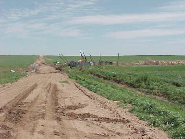
Figure 2. This picture was taken approximately 4 miles west-southwest of Cherokee, looking east. This was near the start of the damage path and shows the destruction of a wood frame/sheet metal hay storage barn. Debris from this structure was scattered for about a half mile to the northeast.
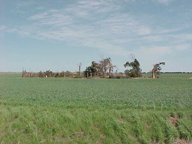
Figure 3. This photograph was taken approximately 3 miles west of Cherokee (2 miles southwest of Ingersoll), looking east. The tornado was at maximum intensity at this location. The photograph shows complete destruction of a hay storage barn and significant damage to trees. Along the road from where this picture was taken, 2 large power line support structures were also blown down.
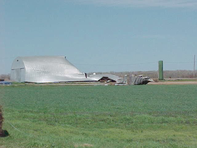
Figure 4. This picture was taken 4 miles north of Cherokee (2 miles northeast of Ingersoll) looking northeast. Significant damage is noted to a storage building at a feedlot at this location. This is near the end of the damage path left by this tornado.
Another tornado path was surveyed south of Wakita. This tornado began at approximately 550 AM CDT 8 miles south-southwest of Wakita and dissipated 5 miles south of Wakita. The damage path was 3 miles long and 100 yards wide. This tornado also moved mainly through open farmland. One sheet metal/wood frame hay storage building was destroyed and another damaged, in addition to minor tree damage. The weak nature of the structures damaged/destroyed by this tornado warrants an F0 intensity rating. No pictures of this damage are available.
In addition to the tornadoes detailed above, severe weather occurred at other locations also associated with these storms. Wind damage occurred at approximately 315 AM CDT 12 miles west of Alva at the junction of highways 64 and 14. This was associated with an earlier storm. Three other severe weather reports of significance were associated with the storm that produced the tornado south of Wakita. A brief tornado occurred at approximately 510 AM CDT 7 miles southwest of Lahoma and another brief tornado occurred at approximately 530 AM CDT 2 miles north of Carrier. Finally, this storm also produced wind damage 12 miles north-northwest of Medford at approximately 610 AM CDT.
Post event analysis and verification on this event was very difficult owing mainly to the time of day when the storms occurred. There were relatively few spotter reports because of darkness and low visibility during the storms.
The National Weather Service would like to thank George Washburn, Alfalfa County Emergency Management, Charlie Conhagan, Kay County Emergency Management and Ron Schaefer, Alfalfa Electric Coop for their assistance in obtaining locations and times of storm damage reports.

