Isolated severe thunderstorms with locally damaging wind gusts and hail are possible Monday across parts of the Southeast U.S. Elevated to critical fire weather including gusty winds and low relative humidity is forecast Monday over much of the northern Great Plains. Above normal temperatures in the Southeast and Southwest U.S. will bring moderate to isolated major HeatRisk Monday. Read More >
The mid to late 1980s were a relatively calm era in Oklahoma and north Texas tornado history, at least as far as the lack of violent tornadoes (tornadoes classified as F4 or F5 on the Fujita Scale). After April 29, 1984 when a violent tornado struck Mannford (near Lake Keystone), there were no violent tornadoes in the state for almost 7 years. This is the longest period of time that the state has gone without a violent tornado since tornado data began to be regularly compiled in 1950, and likely dating back to statehood.
Within the Oklahoma and north Texas counties currently served by the NWS Norman, there were no violent tornadoes for almost 10 years after the Binger tornado of May 22, 1981. Furthermore, no violent tornadoes had occurred within the entire state of Oklahoma since 1984. Unfortunately, those streaks ended on April 26, 1991.
The day started ominously as storms formed across central and western Oklahoma in the early morning hours and moved northeast. A tornado struck the town of Tonkawa in northern Oklahoma about an hour after sunrise. These early storms moved northeast into Kansas and weakened in the late morning hours, but a dry line remained across central Kansas into central Oklahoma.
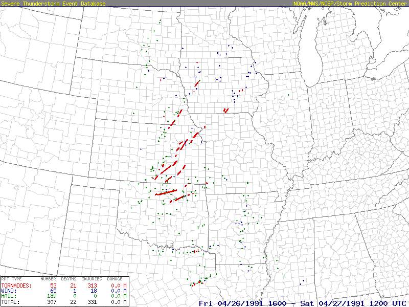
Storms redeveloped in the afternoon along the dry line and an outbreak of tornadoes across much of the central and southern plains ensued. Before the event had concluded, over 50 tornadoes had touched down in Oklahoma, Texas, Kansas, Missouri, Nebraska and Iowa, including five violent tornadoes that occurred in southern Kansas and Oklahoma. The deadliest tornado occurred in the Wichita, Kansas area when an F5 tornado moved through the southern and eastern portions of the Wichita metropolitan area, including McConnell Air Force Base and the town of Andover.
Four other tornadoes received F4 ratings in this outbreak, with three of these violent twisters occurring in Oklahoma.One of these overturned several cars on the Cimarron Turnpike before the striking the towns of Westport and Skiatook. This tornado killed one person and injured another 24. A second F4 tornado injured 22 when it struck Oologah, Oklahoma to the northeast of Tulsa. The other violent tornado was the only one to strike within the NWS Norman area of responsibility, initially touching down east of Enid, about 2.5 miles east of Garber, and it is this tornado that became known as the "Red Rock" tornado. It touched down at 6:30 pm, and moved northeast about 66 miles over the next hour and a half, making this one of the longest tornado paths documented in Oklahoma.
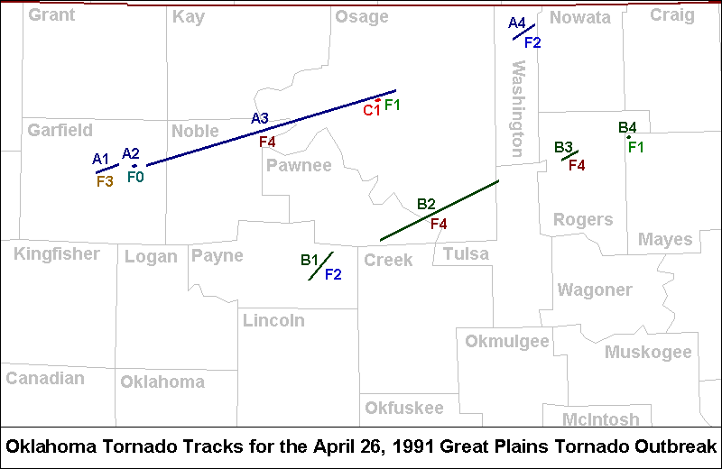
Another 6 tornadoes also occurred in north central and northeastern Oklahoma during the late afternoon and evening of April 26, 1991. The nine tornado tracks in Oklahoma can be viewed in the map shown below, and more information can be viewed in the tornado table for the event. Of the 9 tornadoes to occur in Oklahoma, 4 of these (Tornadoes A1, A2, A3 & B1) occurred in the NWS Norman forecast area.
 |
 |
Supercell thunderstorms developed in northwestern Oklahoma in the afternoon hours, and moved into north-central and northeastern Oklahoma in the late afternoon and evening hours. A total of nine tornadoes occurred, including 4 tornadoes from a parent supercell thunderstorm (Storm A) that moved over Garfield, Noble, Osage, and Washington Counties. Four more twisters were spawned from a supercell thunderstorm (Storm B) that moved along a path parallel, but south of the Storm A’s path through Payne, Pawnee, southern Osage, Tulsa, and Rogers Counties. A third supercell thunderstorm (Storm C) produced one additional tornado in Osage County.
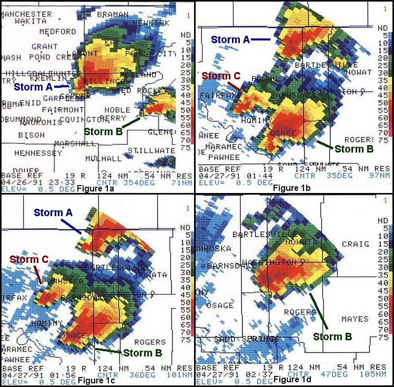
The 4-panel display below shows radar reflectivity images during the evening of April 26, 1991 from the Norman, Oklahoma (KOUN) WSR-88D radar. Figure 1a shows Storm A near Billings, OK and Storm B east of Nobile, OK at 6:33 pm CST. Figure 1b shows Storm A approaching Washington County, Storm B in southeastern Osage County, and Storm C just to the northeast of Storm B at 7:44 pm CST. Figure 1c shows Storm A over Washington County, Storm B still in southeastern Osage County, and Storm C still to the northeast of Storm B at 7:56 pm CST. Figure 1d shows Storm B over northern Rogers County at 8:37 pm CST. More radar images can be found on the NWS Tulsa event page for the April 26, 1991 tornado outbreak.
Tornado A1, the first tornado produced by Storm A, touched down on the eastern side of Woodring Airport in Enid in Garfield County at 5:00 pm CST. It intensified as it moved northeast, destroying two homes 2 homes south of Breckinridge. At this point, a pickup truck was rolled 150 yards and destroyed. Damage is estimated at $70,000. The tornado dissipated 4 miles west of Garber.
Tornado A2 briefly touched down 0.5 miles west of Garber in Garfield County at 5:15 pm CST. It moved northeast less than 0.25 miles and dissipated, causing only minor F0 intensity damage.
Tornado A3, known as the “Red Rock” tornado, touched down 2.5 miles east of Garber at approximately 5:30 pm CST and moved northeast. The tornado increased to F3 intensity as it passed 4.5 miles south of Billings. Oil tanks were destroyed, well pumps toppled, and power poles snapped. The path width at this point was estimated at 0.5 miles.
The tornado grew to a width of 0.75 miles and destroyed a home 5 miles southeast of Billings. The tornado strengthened to F4 intensity as it approached Interstate 35, debarking many trees and destroying a home. The tornado continued east-northeast across Noble County, passing south of Marland and north of the Otoe Indian Agency, and destroying at least two farms along the way. The tornado continued on into Osage County, where its intensity dropped to F3, and moved just to the north of Fairfax where many trees were uprooted and a house was damaged. Ten miles west of Pawhuska, a large oil rig with an 18-inch foundation was toppled.
The tornado lifted at 6:55 pm CST, 9 miles west-northwest of Pawhuska, with a total path length of 66 miles. Damage was estimated at $500 000. Damage incurred at one totally-destroyed farm alone was estimated at $200,000. Several county roads were destroyed when large sections of asphalt were blown away. There were six injuries in this tornado, but none were serious.
Tornado A4 occurred 1 mile south-southwest of Copan in Washington County at 8:05 pm CST and destroyed a convenience store and bait shop, along with damage to other buildings and trees. Two women were waiting in their car for the storm to Pl1ss, when the tornado picked the car up and tossed it into a field 250 yards to the northeast. The passenger was killed and the driver was critically injured. Nine other people were also injured in Copan. The tornado continued intermittently to the northeast, and lifted at 8:20 pm CST, just before crossing into Nowata County. The tornado was rated an F2. Damage was estimated at $100,000.
Another 4 tornadoes occurred with a parent supercell thunderstorm (Storm B) which intensified rapidly over Payne County at 6:00 pm CST, and moved through Pawnee, southern Osage, northern Tulsa, northern Washington, northern Rogers, southern Nowata, Craig, and Ottawa Counties before moving into Missouri around 11:45 pm CST.
Tornado B1 developed 12 miles east-southeast of Stillwater in Payne County and moved northeast. It was wide (0.5 miles), but weak at the beginning. It crossed State Highway 51, 6.5 miles west of Yale. Total path length was 6.5 miles. In the middle part of its lifetime, the tornado was the strongest. It narrowed to 100 yards in width, but strengthened. A dump truck was rolled for 200 yards, a metal shop building and a large, well-built barn were destroyed (all F2 damage), two homes sustained roof damage, and trees and power poles were knocked down (F1 damage.) The tornado began at 6:38 pm CST and ended at 6:47 pm CST, Damage was estimated at $60,000.
Tornado B2 went along a 32-mile path from 1.5 miles west-southwest of Terlton to 1 mile north-northwest of Skiatook. It began at 7:10 pm CST and ended at 8:27 pm CST. The tornado narrowly missed the town of Terlton as it moved east-northeast. Northeast of Terlton and west of State Highway 48, the tornado was weak (F0 damage to trees.) As the tornado crossed Highway 48 a half mile south of the Cimarron Turnpike, it strengthened with F1 and F2 intensity damage to structures and power poles. Up to that point it had been one-eighth mile in width.
After crossing Highway 48, the tornado widened rapidly to about 1 mile and intensity increased to F4 damage as it crossed the turnpike. Several cars were swept off the turnpike with five injuries and one fatality. A man was killed when his car was overturned. The tornado then crossed into the Keystone Airpark at 7:30 pm CST and caused significant damage to four hangers, and seven aircraft were destroyed. Two of the planes were tossed into trees. The fire station at the airport was demolished, with one of the fire engines pushed across the runway and flung into an area of trees about 0.25 mile away. The Ridgemont Estates Subdivision 1 mile east of Westport was hard hit, with F4 damage to homes and trees.
In the Westport area, 54 homes were completely demolished, 8 homes suffered substantial damage, and 32 homes suffered minor damage. Also destroyed were 70 vehicles, 5 mobile homes, 18 outbuildings, and 3 travel trailers. The community center at Westport also suffered damage. There were no fatalities and no reported injuries at Westport. The tornado was 400-yards wide in the Westport area.
The tornado crossed Keystone Lake into Osage County at 7:44 pm CST, and briefly lifted in the vicinity of New Prue. The tornado then touched down again east-northeast of New Prue O.5 miles southwest of the John Zink Scout Ranch and destroyed the lodge there, where a group of Girl Scouts had taken cover. There were no reported injuries among the scouts. All trees along the path of the tornado were snapped off or uprooted, as it continued to the northeast, to the extreme south edge of Skiatook Lake, where some boat docks and a marina were damaged.
The tornado continued to 1.5 miles west of Skiatook on Highway 20 where there was damage to a propane company at 8:15 pm CST. The tornado moved on to a subdivision 1 mile west-northwest of Skiatook. In this area 32 homes were destroyed, 11 homes suffered major damage, and 45 homes suffered minor damage. There were 19 injuries in the Skiatook area. The damage was rated at F3 intensity. The tornado continued northeast for a short time and lifted at 8:27 pm CST, shortly before crossing the Tulsa County line. Damage was estimated from this storm at close to $3 million.
Tornado B3 was the most damaging of the evening. It touched down 1 mile west of Oologah in Rogers County at 8:45 pm CST and moved northeast along a short but devastating 4-mile path. It traveled through a subdivision one mile north of Oologah. There were 60 homes and 16 trailers completely destroyed in the Oologah area. Sixteen apartments and thirty barns were also destroyed. There were 22 injuries in tile Oologah area, with 1 serious injury. Major tornado damage occurred at the Oologah School Complex where all buildings (kindergarten through high school) had significant structural damage. The damage was rated F4 intensity with a 0.75-mile path. Significant damage also occurred due to downbursts on the southern flank of the tornado path.
The damage was in a consistent "starburst" pattern from 5 miles southwest of Oologah, to the town itself where a few trees were blown down and roof damage occurred. Heavy damage also occurred to several homes and two mobile homes 1.5 miles southwest of Oologah. Large towers supporting high tension wires from the Oologah power plant were blown down. All the towers along a 1-mile stretch were blown down toward the east-southeast. The tornado lifted at 8:55 pm CST just west of Oologah Lake. Damage was estimated at close to $15 million, and $12 million alone in damage to the Oologah School Complex.
Tornado B4 touched down west of Chelsea in Rogers County at 9:10 pm CST. It destroyed two homes and two mobile homes on the northwestern side of Chelsea. The damage path was 2 miles long and very narrow. It lifted at 9:15 pm CST, and was described as rope-like. There were three minor injuries and the tornado was classified as Fl.
Tornado C1 occurred in Osage County, from an associated supercell thunderstorm (Storm C) which developed just to the south of the Storm A supercell thundestorm, which passed through the area from Garfield to Washington Counties. It produced a tornado at 7:27 pm CST 10 miles west of Pawhuska along Highway 60. The tornado was described by witnesses as rope-shaped. The tornado remained on the ground for 30 seconds. It picked up a car from Highway 60 and tossed it about 50 feet from the roadway. The path was 0.25 miles long and very narrow. It was rated F1 category. Damage to homes and mobile homes was estimated at $75,000.
In addition to the tornadoes, many reports of large hail (up to soft ball-size and strong thunderstorm winds (up to 80 mph) were received.
The mid to late 1980s were a relatively calm era in Oklahoma and north Texas tornado history, at least as far as the lack of violent tornadoes (tornadoes classified as F4 or F5 on the Fujita Scale). After April 29, 1984 when a violent tornado struck Mannford (near Lake Keystone), there were no violent tornadoes in the state for almost 7 years. This is the longest period of time that the state has gone without a violent tornado since tornado data began to be regularly compiled in 1950, and likely dating back to statehood.
Within the Oklahoma and north Texas counties currently served by the NWS Norman, there were no violent tornadoes for almost 10 years after the Binger tornado of May 22, 1981. Furthermore, no violent tornadoes had occurred within the entire state of Oklahoma since 1984. Unfortunately, those streaks ended on April 26, 1991.
The day started ominously as storms formed across central and western Oklahoma in the early morning hours and moved northeast. A tornado struck the town of Tonkawa in northern Oklahoma about an hour after sunrise. These early storms moved northeast into Kansas and weakened in the late morning hours, but a dry line remained across central Kansas into central Oklahoma.
Storms redeveloped in the afternoon along the dry line and an outbreak of tornadoes across much of the central and southern plains ensued. Before the event was over, 55 tornadoes had touched down in Oklahoma, Texas, Kansas, Missouri, Nebraska and Iowa, including five violent tornadoes that occurred in southern Kansas and Oklahoma. The deadliest tornado occurred in the Wichita, Kansas area when an F5 tornado moved through the southern and eastern portions of the Wichita metropolitan area, including McConnell Air Force Base and the town of Andover.
Four other tornadoes received F4 ratings in this outbreak, with three of these occurring in Oklahoma. One of these overturned several cars on the Cimarron Turnpike before the striking the towns of Westport and Skiatook. This tornado killed one person and injured another 24. A second F4 tornado injured 22 when it struck Oologah, Oklahoma to the northeast of Tulsa.
The third violent tornado in Oklahoma was the only one to strike within the NWS Norman area of responsibility, initially touching down east of Enid, about 2.5 miles east of Garber, and it is this tornado that became known as the "Red Rock" tornado. It touched down at 6:30 pm, and moved northeast about 66 miles over the next hour and a half, making this one of the longest tornado paths documented in Oklahoma. At times, the tornado was about 3/4 of a mile wide. Fortunately, despite the long path of this large tornado, there were no fatalities and only six injuries, none of which were serious. This tornado crossed Interstate 35, but did not directly strike any towns. It got its name as it passed between the communities of Marland and Red Rock.
This tornado was also noteworthy because it was well documented by severe storm researchers. A research team from the University of Oklahoma (including current NWS Norman forecaster Doug Speheger) was able to record wind information from the tornado using a portable Doppler Radar. The radar was set up along U.S. Highway 77 just a mile or two north of State Highway 15 in Noble County, and the tornado crossed U.S. 77 north of the research crew.
As the tornado passed the highway, peak wind speeds over 270 mph were recorded with the Red Rock tornado, which was the highest known measured wind speed of a tornado until May 3, 1999 tornado near Bridge Creek, Oklahoma. It should be noted however that very few tornadoes have actually had wind speeds measured at close range by Doppler Radar. The Red Rock tornado was likely only the 10th tornado to ever have had radar-based wind speed measurement taken.
In the vast majority of tornadoes, the intensity is estimated based upon the damage that is caused, so it is difficult to compare the intensity of the Red Rock tornado to other historic tornadoes. The wind speeds measured were technically within the wind speed range given by Fujita as F5 (winds above 260 mph), but the wind speeds were measured at a height closer to the top of the visible tornado, rather than to the part of the tornado near the ground. Therefore, it is unclear how strong the winds may have been closer to the ground. An F4 rating was assigned based on the destruction of a few houses in Noble County observed during the post-storm damage survey.

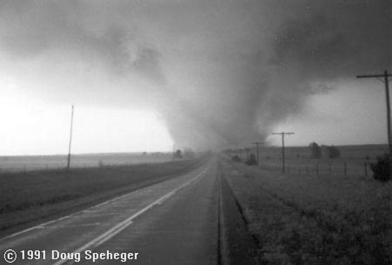
The following photos of the April 26, 1991 Red Rock tornado are provided courtesy of storm chaser Gene Moore and are from the NWS Tulsa, OK April 26, 1991 event web page.
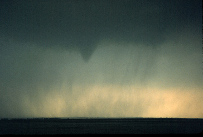 |
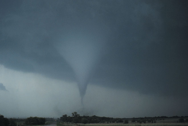 |
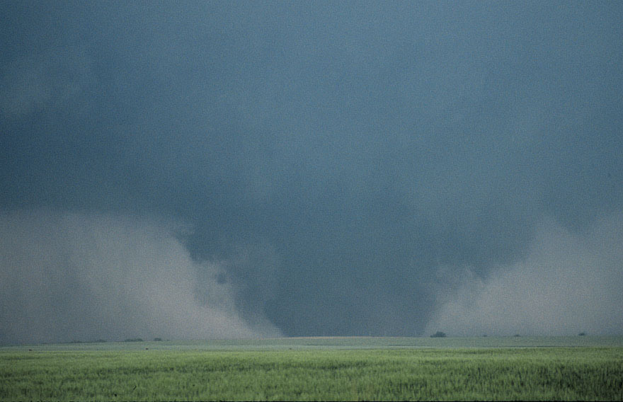 |
 |
| Tornadoes by Intensity | ||||||
|---|---|---|---|---|---|---|
| F0 | F1 | F2 | F3 | F4 | F5 | Total |
| 1 | 2 | 2 | 1 | 3 | 0 | 9 |
| Tornado Number |
Event Tornado ID |
Date | Time (CST) |
Length of Path (miles) |
Width of Path (yards) |
F-Scale | Killed | Injured | County | Location |
|---|---|---|---|---|---|---|---|---|---|---|
| 1 | A1 | 04/26/1991 | 1700-1708 | 6 | 350 | F3 | 0 | 0 | Garfield | 6 E Enid - 4 W Garber |
| 2 | A2 | 04/26/1991 | 1715 | 0.1 | 20 | F0 | 0 | 0 | Garfield | 0.5 W Garber |
| 3 | A3 | 04/26/1991 | 1730-1855 | 66 | 1500 | F4 | 0 | 6 | Garfield/ Noble/ Osage | 3 E Garber - 5 SE Billings - 9 WNW Pawhuska |
| 4 | B1 | 04/26/1991 | 1838-1847 | 7 | 800 | F2 | 0 | 0 | Payne | 12 ESE Stillwater - 2 WNW Yale |
| 5 | B2 | 04/26/1991 | 1910-2027 | 32 | 1700 | F4 | 1 | 24 | Pawnee/ Osage | 1.5 WSW Terlton - Westport - 1 NNW Skiatook |
| 6 | C1 | 04/26/1991 | 1927 | 0.3 | 10 | F1 | 0 | 0 | Osage | 10 W Pawhuska |
| 7 | A4 | 04/26/1991 | 2005-2020 | 6 | 100 | F2 | 1 | 10 | Washington | 1 SSW - 5 ENE Copan |
| 8 | B3 | 04/26/1991 | 2045-2055 | 4 | 1300 | F4 | 0 | 22 | Rogers | 1 W - 3 NE Oologah |
| 9 | B4 | 04/26/1991 | 2110-2115 | 2 | 30 | F1 | 0 | 3 | Rogers | 1 W - 2 N Chelsea |

| Tornadoes by Intensity | ||||||
|---|---|---|---|---|---|---|
| F0 | F1 | F2 | F3 | F4 | F5 | Total |
| 12 | 13 | 16 | 7 | 4 | 1 | 53 |
| Event # |
SPC # |
Date | Time (CST) |
Length of Path (miles) |
Width of Path (yards) |
F-Scale | Killed | Injured | State | County | Location |
|---|---|---|---|---|---|---|---|---|---|---|---|
| 1 | 304 | 04/26/1991 | 1425 | 3.5 | 100 | F2 | 0 | 6 | KS | Washington | 3 W - 2 N Washington |
| 2 | 305 | 04/26/1991 | 1440-1445 | 1 | 50 | F1 | 0 | 0 | NE | Fillmore | Ohiowa - 1 NE Ohiowa |
| 3 | 306 | 04/26/1991 | 1445 | 1 | 17 | F0 | 0 | 0 | KS | Chase | 2 N Strong City |
| 4 | 307 | 04/26/1991 | 1450-1540 | 24 | 200 | F3 | 0 | 0 | KS/ NE | Washington KS/ Gage NE | 3 SE Hollenberg KS - Latham KS - 5 SW Odell NE - 2 SE Beatrice NE |
| 5 | 308 | 04/26/1991 | 1510-1528 | 13 | 50 | F0 | 0 | 0 | KS | Morris/ Wabaunsee | 2 NW Council Grove - Council Grove Reservoir - 10 SW Hessdale |
| 6 | 309 | 04/26/1991 | 1535-1635 | 44 | 200 | F2 | 0 | 0 | KS | Wabaunsee/ Shawnee / J | 10 SW Eskridge - 3 SW Rossville - Rossville - 3 N Grove - 5 SW Argonia |
| 7 | 310 | 04/26/1991 | 1600-1615 | 4 | 150 | F2 | 0 | 0 | NE | Gage | 2 S - 3 NE Adams |
| 8 | 311 | 04/26/1991 | 1615-1640 | 14 | 350 | F3 | 0 | 2 | NE | Otoe | 2 NW Douglas - 7 NE Palmyra |
| 9 | 312 | 04/26/1991 | 1620 | 1 | 50 | F0 | 0 | 0 | KS | Harper | 6 N Anthony |
| 10 | 313 | 04/26/1991 | 1630-1638 | 16 | 50 | F0 | 0 | 0 | KS | Harper/ Sumner | 1 SE Freeport - 3 SW Argonia - 1 SW Conway Springs |
| 11 | 314 | 04/26/1991 | 1647 | 2 | 50 | F1 | 0 | 0 | KS | Sedgwick | Goddard |
| 12 | 315 | 04/26/1991 | 1657-1810 | 46 | 440 | F5 | 17 | 225 | KS | Sedgwick/ Butler | 5 W Clearwater - 2 SSE Clearwater - 1 SW Andover - 5 N El Dorado |
| 13 | 316 | 04/26/1991 | 1700 | 6 | 350 | F3 | 0 | 0 | OK | Garfield | 6 E Enid - 4 W Garber |
| 14 | 317 | 04/26/1991 | 1710 | 6 | 50 | F1 | 0 | 0 | KS | Sedgwick/ Harvey | Valley Center - 3 E Sedgwick |
| 15 | 318 | 04/26/1991 | 1715 | 0.1 | 20 | F0 | 0 | 0 | NE | Pierce | 6 SSW Plainview |
| 16 | 319 | 04/26/1991 | 1715 | 0.1 | 20 | F0 | 0 | 0 | OK | Garfield | 0.5 W Garber |
| 17 | 320 | 04/26/1991 | 1730 | 66 | 1500 | F4 | 0 | 6 | OK | Garfield/ Noble/ Osage | 3 E Garber - 5 SE Billings - 9 WNW Pawhuska |
| 18 | 321 | 04/26/1991 | 1730 | 25 | 500 | F4 | 1 | 0 | KS | Cowley | 5 W Arkansas City - 2 SE Winfield - 3 NW Burden |
| 19 | 322 | 04/26/1991 | 1735 | 9 | 20 | F0 | 0 | 0 | KS | Wabaunsee | 3 W Alma - 4 N Paxico |
| 20 | 323 | 04/26/1991 | 1800-1801 | 0.2 | 10 | F2 | 0 | 0 | TX | Cherokee | Reese |
| 21 | 324 | 04/26/1991 | 1810-1835 | 21 | 100 | F2 | 0 | 4 | KS | Butler/ Chase | 10 NE El Dorado - 3 ENE Cassoday - 4 E Matfield Green (possibly 2 tornadoes) |
| 22 | 325 | 04/26/1991 | 1811-1816 | 3 | 200 | F3 | 0 | 1 | TX | Cherokee | 1 SW - 1 NE Mount Selman |
| 23 | 326 | 04/26/1991 | 1826 | 14 | 200 | F3 | 1 | 2 | KS | Elk/ Greenwood | 7 W Howard - 2 SW Severy |
| 24 | 327 | 04/26/1991 | 1838 | 6.5 | 800 | F2 | 0 | 0 | OK | Payne | 12 ESE Stillwater - 2 WNW Yale |
| 25 | 328 | 04/26/1991 | 1840 | 1 | 50 | F0 | 0 | 0 | KS | Chase | 3 NE Elmdale |
| 26 | 329 | 04/26/1991 | 1840-1850 | 3 | 100 | F2 | 0 | 0 | TX | Smith/ Rusk | 3 W Turnertown - Turnertown |
| 27 | 330 | 04/26/1991 | 1844-1847 | 2 | 47 | F1 | 0 | 0 | IA | Shelby | 2.5 E Panama - 2 N Westphalia |
| 28 | 331 | 04/26/1991 | 1900-1917 | 7.7 | 150 | F3 | 0 | 0 | IA | Crawford/ Sac | Denison - Wall Lake |
| 29 | 332 | 04/26/1991 | 1900-1901 | 0.2 | 10 | F2 | 0 | 0 | TX | Rusk | 3 W Henderson |
| 30 | 333 | 04/26/1991 | 1910 | 32 | 1700 | F4 | 1 | 24 | OK | Pawnee/ Osage | 1.5 WSW Terlton - Westport - 1 NNW Skiatook |
| 31 | 334 | 04/26/1991 | 1922-1923 | 0.2 | 10 | F1 | 0 | 0 | TX | Rusk | Near Henderson |
| 32 | 335 | 04/26/1991 | 1927 | 0.3 | 10 | F1 | 0 | 0 | OK | Osage | 10 W Pawhuska |
| 33 | 336 | 04/26/1991 | 1933 | 1 | 50 | F0 | 0 | 0 | KS | Sedgwick | 7 S Wichita |
| 34 | 337 | 04/26/1991 | 1935-1957 | 15 | 50 | F3 | 0 | 0 | KS | Greenwood/ Woodson | 5 S Neal - 3 SE Quincy - 5 NE Quincy |
| 35 | 338 | 04/26/1991 | 1954-2013 | 11 | 20 | F1 | 0 | 4 | KS | Shawnee/ Jefferson | 5 NE Topeka - 8 NE Topeka - 4 W Ozawkie |
| 36 | 339 | 04/26/1991 | 2000-2030 | 18 | 60 | F2 | 0 | 0 | IA | Dickinson | 5 SW - 2 NW Milford |
| 37 | 340 | 04/26/1991 | 2005 | 6 | 100 | F2 | 1 | 10 | OK | Washington | 1 SSW - 5 ENE Copan |
| 38 | 341 | 04/26/1991 | 2025-2105 | 25 | 27 | F2 | 0 | 2 | KS | Jefferson/ Atchison | 5 SW Nortonville - Nortonville - 2 SW Doniphan |
| 39 | 342 | 04/26/1991 | 2045 | 4 | 1300 | F4 | 0 | 22 | OK | Rogers | 1 W - 3 NE Oologah |
| 40 | 343 | 04/26/1991 | 2100-2101 | 0.2 | 10 | F2 | 0 | 0 | TX | Red River | 2 S Detroit |
| 41 | 344 | 04/26/1991 | 2110 | 2 | 30 | F1 | 0 | 3 | OK | Rogers | 1 W - 2 N Chelsea |
| 42 | 345 | 04/26/1991 | 2115 | 1.8 | 50 | F1 | 0 | 0 | MO | Andrew | Helena |
| 43 | 346 | 04/26/1991 | 2119-2120 | 0.2 | 10 | F1 | 0 | 0 | TX | Red River | Bagwell |
| 44 | 347 | 04/26/1991 | 2120 | 1 | 50 | F0 | 0 | 0 | KS | Montgomery | 5 W Coffeyville |
| 45 | 348 | 04/26/1991 | 2130-2131 | 0.2 | 10 | F2 | 0 | 0 | TX | Red River | 2 N Dimple |
| 46 | 349 | 04/26/1991 | 2210-2222 | 9 | 60 | F2 | 0 | 0 | IA | Wayne | Allerton - Millerton |
| 47 | 350 | 04/26/1991 | 2210-2228 | 15 | 77 | F2 | 0 | 2 | IA | Wayne | 6 SE Allerton - 10 E Millerton |
| 48 | 351 | 04/26/1991 | 2239 | 0.2 | 50 | F0 | 0 | 0 | MO | Newton | 1 N Redings Mill (Near 1-44) |
| 49 | 352 | 04/26/1991 | 2257 | 1.5 | 50 | F1 | 0 | 0 | MO | Andrew | Cosby |
| 50 | 353 | 04/26/1991 | 2305 | 0.1 | 10 | F0 | 0 | 0 | MO | Jasper | West Joplin |
| 51 | 354 | 04/27/1991 | 0055-0104 | 4.5 | 50 | F2 | 0 | 0 | IA | Iowa | 2 S - 3 E Victor |
| 52 | 355 | 04/27/1991 | 0105-0106 | 0.2 | 10 | F1 | 0 | 0 | TX | Red River | 2 N Detroit |
| 53 | 356 | 04/27/1991 | 0109-0112 | 2 | 40 | F1 | 0 | 0 | IA | Iowa | 4 S - 3 SE Marengo |
