As the month of May 1954 began, wet and storm weather prevailed. During the afternoon and early evening of May 1, 1954, 13 tornadoes occurred across what is now the NWS Norman forecast area in western/central Oklahoma and western north Texas. Another tornado occurred during the evening of May 1st in Pittsburg and McIntosh counties in east central Oklahoma. A few more tornadoes also occurred in other areas of north Texas and southern Kansas.
Two people were killed as a direct result of tornadoes and 93 people were injured. Two more people drowned in floodwaters due to heavy rainfall and runoff. Destruction and damage to property and crops mounted to an estimated $3,353,000. This damage estimate includes damage by numerous hail and windstorms. The hail stones ranged up to golf ball size and wind gusts were estimated up to 90 miles per hour.
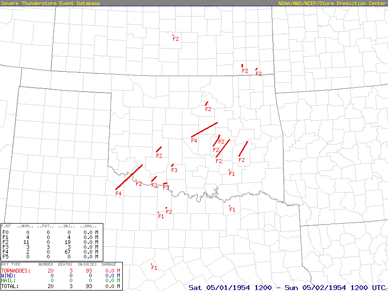
Heavy showers and thunderstorms, which set in over most sections of the region in late April 1954, continued through the first two days of May 1954. The heavy rainfall, which produced heavy runoff and flooding, resulted in considerable soil erosion and damage to recently planted crops.
Flooding occurred along several of the larger rivers in Oklahoma. In east central Oklahoma, where the rains were especially heavy, flood losses along the Deep Fork River were estimated by the U.S. Army Corps of Engineers at $5,000 to structures and $30,000 to croplands. Along the Canadian River, damages were estimated at $25,000 to structures and $40,000 to croplands. Damages along the Illinois River above Tenkiller Ferry Dam, as estimated by the U.S. Weather Bureau, totaled $2,000 to crops and $3,000 to cattle.
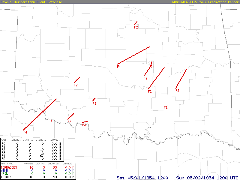
| Tornadoes by Intensity | ||||||
| F0 | F1 | F2 | F3 | F4 | F5 | Total |
| 0 | 1 | 7 | 3 | 2 | 0 | 13 |
| Tornado Number |
Date | Time (CST) |
Length of Path (miles) |
width of Path (yards) |
F-Scale | Killed | Injured | County | Location | |
|---|---|---|---|---|---|---|---|---|---|---|
| 1 | 05/01/1954 | 1416-1530 | 69 | 440 | F4 | 0 | 2 | Foard TX/ Wilbarger TX/ Tillman/ Kiowa | Crowell and Elliot areas TX - E of Tipton - near Snyder [The injuries occurred in TX.] | |
|
The first tornado of the outbreak began near the town of Crowell in Foard County and moved northeastward through Wilbarger County in western north Texas, passing 4 miles to the northwest of Vernon. Five outbuildings were destroyed and 3 homes were demolished. In addition, two homes and an oil mill had lost their roofs. One automobile was picked up by the tornado and thrown a half mile in distance. Only light damage was reported to crops in Texas. The tornado continued moving northeastward and crossed the Red River into southwestern Oklahoma. Damage in western north Texas was estimated at $100,000. The tornado moved north-northeastward through southwestern Oklahoma from near Grandfield in southwestern Tillman County, and then into Kiowa County near Snyder. Considerable damage occurred to 20 homes and barns, 1 school, and 1 cotton gin. The tornado was observed by many people as it passed through the area, and was accompanied by hail to the size of golf balls. Damages in Kiowa County estimated at $5,000 from the tornado and $2,000 from hailstones. Damages from the tornado in Tillman County were estimated at $400,000, with only minor hail damage occurring in the county. |
||||||||||
| 2 | 05/01/1954 | 1530-1540 | N/A | 33 | F2 | 0 | 0 | Tillman | W of Davidson | |
|
The second tornado also occurred in Tillman County and damaged 3 farmsteads as it moved to the northeast west of Davidson, OK for about 10 minutes. Damage was estimated at $10,000. |
||||||||||
| 3 | 05/01/1954 | 1600-1625 | 12 | N/A | F3 | 3* | 3 | Tillman/ Cotton | Near Grandfield - near Ahpeatone (~12 W Walters) | |
|
This tornado began around 4:00 PM CST and moved from near Grandfield in Tillman County northeastward to the Ahpeatone Community in Cotton County. Two people were killed in Ahpeatone. *A third person died during flash flooding. Damages were estimated at $500,000. The tornado was accompanied by extensive hail losses throughout Cotton County, which were estimated at $1 million. |
||||||||||
| 4 | 05/01/1954 | 1650-1655 | 12 | 300 | F2 | 0 | 0 | Caddo | Near Broxton - Near Washita | |
|
A tornado moved northeastward near the towns of Broxton and Washita in Caddo County. The tornado damaged 3 farm houses, and more than a dozen barns and other buildings, resulting in losses of $10,000. |
||||||||||
| 5 | 05/01/1954 | 1742-1758 | 8 | N/A | F2 | 0 | 7 | Payne/ Pawnee | Near Glencoe - near Pawnee (not Cleveland) | |
|
At 5:42 pm CST, 15 farm houses were destroyed and another 11 farm houses were damaged by a tornado that moved northeastward from just northeast of Glencoe, OK in Payne County, to just southwest of Pawnee, OK in Pawnee County. Damage estimates were $25,000 in both Payne and Pawnee Counties. |
||||||||||
| 6 | 05/01/1954 | 1745-1750 | 6 | 100 | F3 | 0 | 0 | Stephens | Near Marlow | |
|
In Stephens County as tornado struck the Marlow area at 5:45 pm CST with $10,000 of damage occurring along its 6-mile-long, 100-yard-wide path. Wind damage also caused extensive losses in and near Duncan where wind gusts were estimated at 90 mph, and damges were estimated at about $100,000. Hail damage to crops in a 25-mile-wide band was estimated at $25,000. |
||||||||||
| 7 | 05/01/1954 | 1745-1830 | (8) | 300 | F3 | 0 | 0 | Cotton/ Jefferson/ Stephens | southern Cotton county - S of Hastings - near Addington - southern Stephens County | |
|
A tornado, described as "barrel-shaped", originated in southern Cotton County at 5:45 pm CST. The tornado moved northeastward to just south of Hastings, OK and then near and northeast of Addington, OK in Jefferson County, before dissipating in southern Stephens County. The damage estimate was $150,000. |
||||||||||
| 8 | 05/01/1954 | 1800 | 0.1 | 33 | F1 | 0 | 0 | Coal | 1 E Coalgate | |
|
A small tornado touched down briefly 1 mile east of Coalgate where it damaged one house and caused $2,500 in damages. The tornado was accompanied by hail which caused another $500 of damage to crops in the area. |
||||||||||
| 9 | 05/01/1954 | 1800 | 59 | N/A | F4 | 0 | 65 | Pottawatomie/ Lincoln/ Creek | NE of Dale - Meeker - Sparks - Davenport - near Depew | |
|
The tornado was first reported at 6:00 pm northeast of the town of Dale in Pottawatomie County. It moved northeastward for 40 miles producing damage in the towns of Meeker, Sparks, and Davenport in Lincoln County. The tornado continued northeastward into Creek County, near the town of Depew. A total of 65 people were injured, but fortunately no one was killed. A large bus was carried 300 feet, and overturned on the U.S. Highway 62 just east of Meeker. Property damage was estimated at $820,000. In Lincoln County, 120 buildings were damaged or destroyed. |
||||||||||
| 10 | 05/01/1954 | 1800-2010 | 39 | N/A | F2 | 0 | 6 | Pontotoc/ Seminole/ Hughes/ Okfuskee | Cedar Grove community - near Spaulding - Sasakwa - near Holdenville.. Yeager.. Wetumka.. Weleetka | |
|
A tornado was observed at 6:00 pm CST about 1 mile east-southeast of Francis, OK and or about 1 mile southwest of the Cedar Grove Community in northern Pontotoc County. As it moved northeastward for about 39 miles, a total of $2.5 milliom in damages occurred in or near the towns of Francis, Sasakwa, Spaulding, Holdenville, Yeager, Wetumka, and Weleetka. |
||||||||||
| 11 | 05/01/1954 | 1815-? | 20 | 100 | F2 | 0 | 0 | Seminole | Near Bowlegs - near Excelsior (possibly ~1 W Schoolton) | |
|
A tornado touched down near Bowlegs and moved northeastward, producing $20,000 of damage in the Bowlegs and Excelsior communities. |
||||||||||
| 12 | 05/01/1954 | 1905-1910 | 6 | 220 | F2 | 0 | 0 | Seminole/ Okfuskee | 1.5 NW Cromwell NNE into western Okfuskee county | |
|
A tornado was first observed 1.5 miles northwest of Cromwell, OK in Seminole County. It continued to the north-northeast along an intermittent path through rural areas in western Okfuskee County where it dissipated. About a half dozen farms were damaged. Total damage was estimated at $50,000. |
||||||||||
| 13 | 05/01/1954 | 1920-2020 | 37 | N/A | F2 | 0 | 6 | Pittsburg/ McIntosh | SW of McAlester (near Naval Ammunition Depot) - near Canadian - southern McIntosh county | |
|
The last Oklahoma tornado on May 1, 1954 began at 7:00 pm CST near the Naval Ammunition Depot southwest of McAlester in Pittsburg County. The tornado moved northeastward to near Canadian, OK and into southern McIntosh County. Total damage was estimated at $34,000. |
||||||||||

| Tornadoes by Intensity | ||||||
| F0 | F1 | F2 | F3 | F4 | F5 | Total |
| 0 | 4 | 11 | 3 | 2 | 0 | 20 |
| Tornado Number |
Date | Time (CST) |
Length of Path (miles) |
width of Path (yards) |
F-Scale | Killed | Injured | County | State | Location |
|---|---|---|---|---|---|---|---|---|---|---|
| 1 | 05/01/1954 | 1416-1530 | 69 | 440 | F4 | 0 | 2 | Foard TX/ Wilbarger TX/ Tillman/ Kiowa | TX-OK | Crowell and Elliot areas TX - E of Tipton - near Snyder [The injuries occurred in TX.] |
|
The first tornado of the outbreak began near the town of Crowell in Foard County and moved northeastward through Wilbarger County in western north Texas, passing 4 miles to the northwest of Vernon. Five outbuildings were destroyed and 3 homes were demolished. In addition, two homes and an oil mill had lost their roofs. One automobile was picked up by the tornado and thrown a half mile in distance. Only light damage was reported to crops in Texas. The tornado continued moving northeastward and crossed the Red River into southwestern Oklahoma. Damage in western north Texas was estimated at $100,000. The tornado moved north-northeastward through southwestern Oklahoma from near Grandfield in southwestern Tillman County, and then into Kiowa County near Snyder. Considerable damage occurred to 20 homes and barns, 1 school, and 1 cotton gin. The tornado was observed by many people as it passed through the area, and was accompanied by hail to the size of golf balls. Damages in Kiowa County estimated at $5,000 from the tornado and $2,000 from hailstones. Damages from the tornado in Tillman County were estimated at $400,000, with only minor hail damage occurring in the county. |
||||||||||
| 2 | 05/01/1954 | 1530-1540 | N/A | 33 | F2 | 0 | 0 | Tillman | OK | W of Davidson |
|
This tornado also occurred in Tillman County and damaged 3 farmsteads as it moved to the northeast west of Davidson, OK for about 10 minutes. Damage was estimated at $10,000. |
||||||||||
| 3 | 05/01/1954 | 1600-1625 | 12 | N/A | F3 | 3* | 3 | Tillman/ Cotton | OK | Near Grandfield - near Ahpeatone (~12 W Walters) |
|
This tornado began around 4:00 pm CST and moved from near Grandfield in Tillman County northeastward to the Ahpeatone Community in Cotton County. Two people were killed in Ahpeatone. *A third person died during flash flooding. Damages were estimated at $500,000. The tornado was accompanied by extensive hail losses throughout Cotton County, which were estimated at $1 million. |
||||||||||
| 4 | 05/01/1954 | 1650-1655 | 12 | 300 | F2 | 0 | 0 | Caddo | OK | Near Broxton - Near Washita |
|
A tornado moved northeastward near the towns of Broxton and Washita in Caddo County. The tornado damaged 3 farm houses, and more than a dozen barns and other buildings, resulting in losses of $10,000. |
||||||||||
| 5 | 05/01/1954 | 1742-1758 | 8 | N/A | F2 | 0 | 7 | Payne/ Pawnee | OK | Near Glencoe - near Pawnee |
|
At 5:42 pm CST, 15 farm houses were destroyed and another 11 farm houses were damaged by a tornado that moved northeastward from just northeast of Glencoe, OK in Payne County, to just southwest of Pawnee, OK in Pawnee County. Damage estimates were $25,000 in both Payne and Pawnee Counties. |
||||||||||
| 6 | 05/01/1954 | 1745-1750 | 6 | 100 | F3 | 0 | 0 | Stephens | OK | Near Marlow |
|
In Stephens County as tornado struck the Marlow area at 5:45 pm CST with $10,000 of damage occurring along its 6-mile-long, 100-yard-wide path. Wind damage also caused extensive losses in and near Duncan where wind gusts were estimated at 90 mph, and damges were estimated at about $100,000. Hail damage to crops in a 25-mile-wide band was estimated at $25,000. |
||||||||||
| 7 | 05/01/1954 | 1745-1830 | (8) | 300 | F3 | 0 | 0 | Cotton/ Jefferson/ Stephens | OK | Southern Cotton County - S of Hastings - near Addington - Southern Stephens County |
|
A tornado, described as "barrel-shaped", originated in southern Cotton County at 5:45 pm CST. The tornado moved northeastward to just south of Hastings, OK and then near and northeast of Addington, OK in Jefferson County, before dissipating in southern Stephens County. The damage estimate was $150,000. |
||||||||||
| 8 | 05/01/1954 | 1800 | 0.1 | 33 | F1 | 0 | 0 | Coal | OK | 1 E Coalgate |
|
A small tornado touched down briefly 1 mile east of Coalgate where it damaged one house and caused $2,500 in damages. The tornado was accompanied by hail which caused another $500 of damage to crops in the area. |
||||||||||
| 9 | 05/01/1954 | 1800 | 0.3 | 300 | F2 | 0 | 0 | Reno | KS | 4 WNW Hutchinson |
|
A tornado touched down briefly 4 miles west-northwest of Hutchinson, KS. The total damages were estimated at $2,500. |
||||||||||
| 10 | 05/01/1954 | 1800-2010 | 59 | N/A | F4 | 0 | 65 | Pottawatomie/ Lincoln/ Creek | OK | NE of Dale - Meeker - Sparks - Davenport - near Depew |
|
The tornado was first reported at 6:00 pm CST northeast of the town of Dale in Pottawatomie County. It moved northeastward for 40 miles producing damage in the towns of Meeker, Sparks, and Davenport in Lincoln County. The tornado continued northeastward into Creek County, near the town of Depew. A total of 65 people were injured, but fortunately no one was killed. A large bus was carried 300 feet, and overturned on U.S. Highway 62 just east of Meeker. Property damage was estimated at $820,000. In Lincoln County, 120 buildings were damaged or destroyed. |
||||||||||
| 11 | 05/01/1954 | 1800-1920 | 39 | N/A | F2 | 0 | 6 | Pontotoc/ Seminole/ Hughes/ Okfuskee | OK | Cedar Grove community - near Sasakwa - Spaulding - near Holdenville.. Yeager.. Wetumka.. Weleetka |
|
A tornado was observed at 6:00 pm CST about 1 mile east-southeast of Francis, OK and or about 1 mile southwest of the Cedar Grove Community in northern Pontotoc County. As it moved northeastward for about 39 miles, a total of $2.5 milliom in damages occurred in or near the towns of Francis, Sasakwa, Spaulding, Holdenville, Yeager, Wetumka, and Weleetka. |
||||||||||
| 12 | 05/01/1954 | 1800 | 5.6 | 33 | F2 | 0 | 0 | Montgomery | KS | 2 E Independence - 3 SE Sycamore |
|
This tornado touched down 2 miles east of Independence, KS and moved to the north before dissipating about 3 miles southeast of Sycamore, KS. The total damages were $25,000. |
||||||||||
| 13 | 05/01/1954 | 1800 | 0.3 | 300 | F2 | 0 | 0 | Labette | KS | 6 SE Altamont - 3 WNW Oswego |
|
A tornado touched down and destroyed some barns about 6 miles southeast of Altamont, KS and then moved northeastward before lifting about 3 miles west-northwest of Oswego, KS. |
||||||||||
| 14 | 05/01/1954 | 1815-? | 20 | 100 | F2 | 0 | 0 | Seminole | OK | Near Bowlegs - near Excelsior (possibly ~1 W Schoolton) |
|
A tornado touched down near Bowlegs and moved northeastward, producing $20,000 of damage in the Bowlegs and Excelsior communities. |
||||||||||
| 15 | 05/01/1954 | 1900 | 1 | 30 | F1 | 0 | 4 | Jack | TX | 1 SW Antelope -Antelope |
|
This tornado began 1 mile southwest of Antelope, TX and moved to the northeast until it demolished a home in Antelope. Four people were injured in Antelope by the tornado. |
||||||||||
| 16 | 05/01/1954 | 1905-1910 | 6 | 220 | F2 | 0 | 0 | Seminole/ Okfuskee | OK | 1.5 NW Cromwell NNE into western Okfuskee county |
|
A tornado was first observed 1.5 miles northwest of Cromwell, OK in Seminole County. It continued to the north-northeast along an intermittent path through rural areas in western Okfuskee County where it dissipated. About a half dozen farms were damaged. Total damage was estimated at $50,000. |
||||||||||
| 17 | 05/01/1954 | 1920-2020 | 37 | N/A | F2 | 0 | 6 | Pittsburg/ McIntosh | OK | SW of McAlester (near Naval Ammunition Depot) - near Canadian - southern McIntosh County |
|
The last Oklahoma tornado on May 1, 1954 began at 7:00 pm CST near the Naval Ammunition Depot southwest of McAlester in Pittsburg County. The tornado moved northeastward to near Canadian, OK and into southern McIntosh County. Total damage was estimated at $34,000. |
||||||||||
| 18 | 05/01/1954 | 2100 | 33 | 1 | F1 | 0 | 0 | Fannin | TX | 1.5 N Bonham - 2.5 NE Bonham |
|
This tornado touched down near the north side of Bonham, TX. No damage estimates were available. |
||||||||||
| 19 | 05/01/1954 | 2115 | n/a | 67 | F2 | 0 | 0 | Clay/ Montague | TX | Near Buffalo Springs - near Bowie |
|
This tornado began at 9:15 pm CST and moved northeast, passing near the Buffalo Springs area, which is about 17 miles west of Bowie, TX. The tornado continued into Montague County before dissipating. it destroyed a cotton gin and a barn along its path. |
||||||||||
| 20 | 05/02/1954 | 0100 | n/a | 33 | F1 | 0 | 0 | Comanche | TX | 1 NW De Leon |
|
A tornado touched down briefly near De Leon, TX |
||||||||||
The following table includes 5-day storm total precipitation amounts from April 29-May 3, 1954 for locations in Oklahoma and 8 counties in western north Texas.
| Location | County | State | Source | Latitude | Longitude | Rainfall Total |
|---|---|---|---|---|---|---|
| Lyons | Adair | OK | COOP | 35.763 | -94.734 | 6.55 |
| Stilwell | Adair | OK | COOP | 35.895 | -94.649 | 6.25 |
| Cherokee | Alfalfa | OK | COOP | 36.767 | -98.424 | 2.21 |
| Great Salt Plains Dam | Alfalfa | OK | COOP | 36.743 | -98.133 | 1.43 |
| Helena | Alfalfa | OK | COOP | 36.538 | -98.266 | 2.34 |
| Daisy | Atoka | OK | COOP | 34.544 | -95.676 | 3.67 |
| Farris | Atoka | OK | COOP | 34.267 | -95.917 | 3.08 |
| Beaver | Beaver | OK | COOP | 36.813 | -100.531 | 0.22 |
| Elk City | Beckham | OK | COOP | 35.393 | -99.506 | 0.12 |
| Erick | Beckham | OK | COOP | 35.216 | -99.863 | 0.67 |
| Moravia | Beckham | OK | COOP | 35.146 | -99.496 | 0.10 |
| Sayre 1 NE | Beckham | OK | COOP | 35.306 | -99.627 | 0.22 |
| Canton | Blaine | OK | COOP | 36.062 | -98.590 | 2.64 |
| Geary | Blaine | OK | COOP | 35.631 | -98.322 | 1.89 |
| Okeene | Blaine | OK | COOP | 36.122 | -98.315 | 0.83 |
| Watonga | Blaine | OK | COOP | 35.858 | -98.414 | 0.35 |
| Durant | Bryan | OK | COOP | 34.000 | -96.369 | 2.79 |
| Yuba | Bryan | OK | COOP | 33.817 | -96.233 | 2.07 |
| Anadarko | Caddo | OK | COOP | 35.062 | -98.199 | 1.80 |
| Apache | Caddo | OK | COOP | 34.888 | -98.360 | 1.89 |
| Carnegie | Caddo | OK | COOP | 35.176 | -98.579 | 1.01 |
| Fort Cobb | Caddo | OK | COOP | 35.104 | -98.443 | 2.09 |
| Lookeba | Caddo | OK | COOP | 35.374 | -98.377 | 0.62 |
| El Reno | Canadian | OK | COOP | 35.549 | -97.955 | 2.10 |
| Union City | Canadian | OK | COOP | 35.367 | -97.887 | 2.31 |
| Ardmore | Carter | OK | COOP | 34.177 | -97.162 | 3.87 |
| Ardmore AFB | Carter | OK | WBAN | 34.300 | -97.017 | 3.19 |
| Ardmore FAA Airport | Carter | OK | WBAN | 34.300 | -97.150 | 2.68 |
| Healdton | Carter | OK | COOP | 34.233 | -97.420 | 4.07 |
| Fort Gibson Dam | Cherokee | OK | COOP | 35.867 | -95.233 | 6.94 |
| Tahlequah | Cherokee | OK | COOP | 35.937 | -94.964 | 5.86 |
| Boswell | Choctaw | OK | COOP | 34.021 | -95.872 | 2.40 |
| Hugo | Choctaw | OK | COOP | 34.021 | -95.538 | 1.82 |
| Sobol Tower | Choctaw | OK | COOP | 34.133 | -95.233 | 2.06 |
| Spencerville | Choctaw | OK | COOP | 34.150 | -95.350 | 1.50 |
| Boise City | Cimarron | OK | COOP | 36.724 | -102.480 | 0.67 |
| Kenton | Cimarron | OK | COOP | 36.903 | -102.965 | 0.37 |
| Kenton 6 N | Cimarron | OK | COOP | 36.983 | -102.983 | 0.28 |
| Regnier | Cimarron | OK | COOP | 36.943 | -102.631 | 0.52 |
| Norman | Cleveland | OK | COOP | 35.181 | -97.438 | 3.13 |
| Norman Univ. of Oklahoma | Cleveland | OK | COOP | 35.217 | -97.433 | 2.65 |
| Coalgate | Coal | OK | COOP | 34.550 | -96.233 | 5.18 |
| Baird 4 N | Comanche | OK | COOP | 34.533 | -98.167 | 3.43 |
| Chattanooga 3 NE | Comanche | OK | COOP | 34.421 | -98.648 | 1.36 |
| Fort Sill Post Field AB | Comanche | OK | WBAN | 34.650 | -98.400 | 2.39 |
| Lawton | Comanche | OK | COOP | 34.610 | -98.457 | 3.09 |
| Wichita Mountain WLR | Comanche | OK | COOP | 34.733 | -98.712 | 2.20 |
| Randlett | Cotton | OK | COOP | 34.158 | -98.311 | 1.74 |
| Walters | Cotton | OK | COOP | 34.360 | -98.301 | 1.26 |
| Hollow | Craig | OK | COOP | 36.881 | -95.287 | 4.72 |
| Vinita | Craig | OK | COOP | 36.547 | -95.132 | 4.13 |
| Bristow | Creek | OK | COOP | 35.829 | -96.392 | 5.38 |
| Heyburn Dam | Creek | OK | COOP | 35.950 | -96.283 | 5.12 |
| Sapulpa | Creek | OK | COOP | 36.000 | -96.133 | 4.85 |
| Clinton | Custer | OK | COOP | 35.501 | -98.977 | 0.09 |
| Weatherford | Custer | OK | COOP | 35.520 | -98.699 | 0.36 |
| Grove | Delaware | OK | COOP | 36.581 | -94.768 | 3.95 |
| Jay | Delaware | OK | COOP | 36.417 | -94.800 | 5.51 |
| South Grand Lake | Delaware | OK | COOP | 36.550 | -94.900 | 4.05 |
| Watts 5 N | Delaware | OK | COOP | 36.183 | -94.567 | 4.86 |
| Camargo | Dewey | OK | COOP | 36.017 | -99.283 | 3.95 |
| Leedey | Dewey | OK | COOP | 35.863 | -99.343 | 4.10 |
| Oakwood 3 SW | Dewey | OK | COOP | 35.900 | -98.733 | 1.38 |
| Taloga | Dewey | OK | COOP | 36.041 | -98.962 | 3.24 |
| Arnett | Ellis | OK | COOP | 36.165 | -99.720 | 0.72 |
| Gage Airport | Ellis | OK | WBAN | 36.297 | -99.769 | 1.44 |
| Shattuck | Ellis | OK | COOP | 36.289 | -99.893 | 1.21 |
| Enid | Garfield | OK | COOP | 36.419 | -97.875 | 2.07 |
| Enid Vance AFB | Garfield | OK | WBAN | 36.333 | -97.917 | 1.82 |
| Garber | Garfield | OK | COOP | 36.433 | -97.583 | 2.54 |
| Waukomis | Garfield | OK | COOP | 36.283 | -97.900 | 0.78 |
| Lindsay | Garvin | OK | COOP | 34.826 | -97.639 | 3.43 |
| Pauls Valley | Garvin | OK | COOP | 34.725 | -97.281 | 3.86 |
| Chickasha | Grady | OK | COOP | 35.033 | -97.950 | 2.69 |
| Chickasha Exp. Station | Grady | OK | COOP | 35.049 | -97.916 | 3.28 |
| Jefferson | Grant | OK | COOP | 36.686 | -97.749 | 1.47 |
| Renfrow | Grant | OK | COOP | 36.926 | -97.631 | 1.02 |
| Mangum | Greer | OK | COOP | 34.891 | -99.502 | 0.13 |
| Hollis | Harmon | OK | COOP | 34.681 | -99.813 | 0.18 |
| Vinson | Harmon | OK | COOP | 34.900 | -99.861 | 0.42 |
| Buffalo | Harper | OK | COOP | 36.800 | -99.640 | 1.69 |
| Laverne | Harper | OK | COOP | 36.699 | -99.897 | 0.35 |
| McCurtain | Haskell | OK | COOP | 35.145 | -94.967 | 4.26 |
| Whitefield | Haskell | OK | COOP | 35.267 | -95.233 | 4.50 |
| Calvin | Hughes | OK | COOP | 34.964 | -96.249 | 4.01 |
| Holdenville | Hughes | OK | COOP | 35.057 | -96.386 | 9.70 |
| Wetumka | Hughes | OK | COOP | 35.261 | -96.208 | 7.37 |
| Altus | Jackson | OK | COOP | 34.590 | -99.334 | 0.26 |
| Altus AFB | Jackson | OK | WBAN | 34.650 | -99.267 | 0.61 |
| Eldorado | Jackson | OK | COOP | 34.467 | -99.650 | 0.17 |
| Waurika | Jefferson | OK | COOP | 34.175 | -97.996 | 3.03 |
| Pontotoc | Johnston | OK | COOP | 34.505 | -96.622 | 6.71 |
| Tishomingo Natl. WLR | Johnston | OK | COOP | 34.207 | -96.642 | 5.05 |
| Blackwell | Kay | OK | COOP | 36.784 | -97.290 | 1.84 |
| Blackwell 1 W | Kay | OK | COOP | 36.800 | -97.300 | 1.40 |
| Newkirk | Kay | OK | COOP | 36.942 | -97.006 | 1.72 |
| Ponca City | Kay | OK | COOP | 36.723 | -97.090 | 2.02 |
| Ponca City Municipal Airport | Kay | OK | WBAN | 36.737 | -97.102 | 1.76 |
| Hennessey | Kingfisher | OK | COOP | 36.094 | -97.835 | 1.04 |
| Kingfisher | Kingfisher | OK | COOP | 35.858 | -97.929 | 0.86 |
| Hobart Municipal Airport | Kiowa | OK | WBAN | 34.989 | -99.052 | 0.13 |
| Roosevelt | Kiowa | OK | COOP | 34.851 | -99.021 | 0.68 |
| Snyder | Kiowa | OK | COOP | 34.650 | -98.954 | 0.60 |
| Wilburton | Latimer | OK | COOP | 34.961 | -95.171 | 3.04 |
| Fanshawe | Le Flore | OK | COOP | 34.951 | -94.908 | 3.57 |
| Heavener | Le Flore | OK | COOP | 34.913 | -94.600 | 2.75 |
| Kiamichi Tower | Le Flore | OK | COOP | 34.633 | -94.817 | 2.57 |
| Poteau | Le Flore | OK | COOP | 35.050 | -94.633 | 2.64 |
| Spiro | Le Flore | OK | COOP | 35.245 | -94.625 | 3.42 |
| Wister Dam | Le Flore | OK | COOP | 34.942 | -94.704 | 2.63 |
| Zoe | Le Flore | OK | COOP | 34.750 | -94.633 | 3.18 |
| Chandler | Lincoln | OK | COOP | 35.706 | -96.880 | 4.00 |
| Meeker | Lincoln | OK | COOP | 35.505 | -96.977 | 4.58 |
| Prague | Lincoln | OK | COOP | 35.488 | -96.730 | 5.21 |
| Crescent | Logan | OK | COOP | 35.927 | -97.674 | 2.54 |
| Guthrie | Logan | OK | COOP | 35.816 | -97.395 | 1.73 |
| Marshall | Logan | OK | COOP | 36.152 | -97.623 | 1.03 |
| Marietta | Love | OK | COOP | 33.876 | -97.164 | 1.93 |
| Orr | Love | OK | COOP | 34.033 | -97.533 | 3.42 |
| Ames | Major | OK | COOP | 36.248 | -98.188 | 1.58 |
| Fairview | Major | OK | COOP | 36.267 | -98.483 | 2.64 |
| Kingston | Marshall | OK | COOP | 33.930 | -96.696 | 2.90 |
| Madill | Marshall | OK | COOP | 34.092 | -96.771 | 3.08 |
| Grand River Dam | Mayes | OK | COOP | 36.467 | -95.050 | 4.44 |
| Pryor | Mayes | OK | COOP | 36.309 | -95.330 | 4.19 |
| Spavinaw | Mayes | OK | COOP | 36.389 | -95.060 | 3.00 |
| Blanchard | McClain | OK | COOP | 35.118 | -97.670 | 2.86 |
| Purcell | McClain | OK | COOP | 34.986 | -97.384 | 2.94 |
| Bear Mountain Tower | McCurtain | OK | COOP | 34.139 | -94.952 | 1.79 |
| Broken Bow | McCurtain | OK | COOP | 34.050 | -94.738 | 2.07 |
| Carnasaw Tower | McCurtain | OK | COOP | 34.144 | -94.638 | 2.04 |
| Carter Tower | McCurtain | OK | COOP | 34.266 | -94.775 | 1.85 |
| Flashman Tower | McCurtain | OK | COOP | 34.483 | -95.000 | 2.90 |
| Hee Mountain Tower | McCurtain | OK | COOP | 34.333 | -94.650 | 1.51 |
| Idabel | McCurtain | OK | COOP | 33.934 | -94.828 | 2.86 |
| Smithville | McCurtain | OK | COOP | 34.468 | -94.643 | 2.87 |
| Valliant | McCurtain | OK | COOP | 33.998 | -95.143 | 1.92 |
| Checotah | McIntosh | OK | COOP | 35.472 | -95.522 | 9.91 |
| Hanna | McIntosh | OK | COOP | 35.203 | -95.890 | 7.36 |
| Sulphur | Murray | OK | COOP | 34.500 | -96.967 | 2.74 |
| Braggs 3 W | Muskogee | OK | COOP | 35.667 | -95.200 | 7.61 |
| Haskell | Muskogee | OK | COOP | 35.826 | -95.693 | 4.58 |
| Muskogee | Muskogee | OK | COOP | 35.778 | -95.334 | 7.66 |
| Webbers Falls | Muskogee | OK | COOP | 35.481 | -95.204 | 7.55 |
| Billings | Noble | OK | COOP | 36.530 | -97.447 | 1.74 |
| Perry | Noble | OK | COOP | 36.289 | -97.290 | 1.66 |
| Red Rock | Noble | OK | COOP | 36.461 | -97.180 | 1.95 |
| Nowata | Nowata | OK | COOP | 36.692 | -95.644 | 5.05 |
| Okemah | Okfuskee | OK | COOP | 35.425 | -96.303 | 5.27 |
| Britton 2 E | Oklahoma | OK | COOP | 35.567 | -97.500 | 2.77 |
| Lake Hefner | Oklahoma | OK | COOP | 35.583 | -97.583 | 2.30 |
| Lake Overholser | Oklahoma | OK | COOP | 35.488 | -97.664 | 2.24 |
| OKC East | Oklahoma | OK | COOP | 35.467 | -97.467 | 3.40 |
| OKC N. Dspl. | Oklahoma | OK | COOP | 35.533 | -97.467 | 4.04 |
| OKC/Penn Avenue | Oklahoma | OK | COOP | 35.483 | -97.533 | 3.45 |
| OKC/Will Rogers World Airport | Oklahoma | OK | WBAN | 35.389 | -97.601 | 2.81 |
| Tinker AFB | Oklahoma | OK | WBAN | 35.417 | -97.383 | 2.98 |
| Dewar | Okmulgee | OK | COOP | 35.456 | -95.907 | 7.47 |
| Okmulgee | Okmulgee | OK | COOP | 35.624 | -96.025 | 5.99 |
| Barnsdall | Osage | OK | COOP | 36.565 | -96.166 | 6.57 |
| Bartlesville Municipal Airport | Osage | OK | WBAN | 36.768 | -96.026 | 5.45 |
| Burbank | Osage | OK | COOP | 36.693 | -96.732 | 4.55 |
| Foraker | Osage | OK | COOP | 36.874 | -96.569 | 3.84 |
| Herd | Osage | OK | COOP | 36.867 | -96.200 | 6.30 |
| Hominy 4 N | Osage | OK | COOP | 36.403 | -96.391 | 5.49 |
| Hulah Dam | Osage | OK | COOP | 36.917 | -96.100 | 5.26 |
| Pawhuska | Osage | OK | COOP | 36.669 | -96.347 | 5.37 |
| Skiatook | Osage | OK | COOP | 36.365 | -96.003 | 3.45 |
| Miami | Ottawa | OK | COOP | 36.883 | -94.883 | 3.85 |
| Quapaw | Ottawa | OK | COOP | 36.967 | -94.783 | 4.42 |
| Wyandotte | Ottawa | OK | COOP | 36.817 | -94.717 | 5.44 |
| Cleveland | Pawnee | OK | COOP | 36.300 | -96.467 | 5.78 |
| Hallett | Pawnee | OK | COOP | 36.250 | -96.600 | 6.63 |
| Mannford | Pawnee | OK | COOP | 36.175 | -96.443 | 3.81 |
| Maramec | Pawnee | OK | COOP | 36.246 | -96.684 | 6.52 |
| Pawnee | Pawnee | OK | COOP | 36.357 | -96.811 | 2.78 |
| Ralston | Pawnee | OK | COOP | 36.504 | -96.744 | 2.97 |
| West Branch | Pawnee | OK | COOP | 36.250 | -96.650 | 6.80 |
| Cushing | Payne | OK | COOP | 35.980 | -96.776 | 3.96 |
| Perkins | Payne | OK | COOP | 35.974 | -97.027 | 3.11 |
| Stillwater | Payne | OK | COOP | 36.118 | -97.095 | 3.35 |
| Eufaula | Pittsburg | OK | COOP | 35.193 | -95.590 | 8.55 |
| McAlester Regional Airport | Pittsburg | OK | WBAN | 34.882 | -95.783 | 5.15 |
| Quinton | Pittsburg | OK | COOP | 35.133 | -95.367 | 4.42 |
| Ada | Pontotoc | OK | COOP | 34.786 | -96.685 | 2.83 |
| Shawnee | Pottawatomie | OK | COOP | 35.355 | -96.920 | 4.47 |
| Tribbey | Pottawatomie | OK | COOP | 35.133 | -97.050 | 4.68 |
| Antlers | Pushmataha | OK | COOP | 34.221 | -95.615 | 2.66 |
| Clayton | Pushmataha | OK | COOP | 34.583 | -95.350 | 2.41 |
| Cloudy Tower | Pushmataha | OK | COOP | 34.383 | -95.250 | 2.28 |
| Signal Mountain Tower | Pushmataha | OK | COOP | 34.317 | -95.050 | 2.40 |
| Cheyenne | Roger Mills | OK | COOP | 35.600 | -99.683 | 3.28 |
| Hammon | Roger Mills | OK | COOP | 35.585 | -99.395 | 2.96 |
| Reydon | Roger Mills | OK | COOP | 35.626 | -99.911 | 8.25 |
| Claremore | Rogers | OK | COOP | 36.323 | -95.581 | 5.19 |
| Sageeyah | Rogers | OK | COOP | 36.367 | -95.667 | 5.02 |
| Konawa | Seminole | OK | COOP | 34.961 | -96.750 | 5.59 |
| Seminole | Seminole | OK | COOP | 35.232 | -96.653 | 3.70 |
| Wewoka 3 W | Seminole | OK | COOP | 35.131 | -96.539 | 6.02 |
| Sallisaw | Sequoyah | OK | COOP | 35.457 | -94.805 | 3.78 |
| Tenkiller Ferry Dam | Sequoyah | OK | COOP | 35.600 | -95.050 | 7.15 |
| Comanche | Stephens | OK | COOP | 34.362 | -97.974 | 4.47 |
| Duncan | Stephens | OK | COOP | 34.501 | -97.959 | 2.95 |
| Marlow | Stephens | OK | COOP | 34.637 | -97.979 | 3.65 |
| Goodwell Research Station | Texas | OK | COOP | 36.591 | -101.618 | 0.18 |
| Guymon | Texas | OK | COOP | 36.703 | -101.478 | 0.34 |
| Guymon 9 NW | Texas | OK | COOP | 36.783 | -101.583 | 0.18 |
| Guymon Lee Ranch | Texas | OK | COOP | 36.533 | -101.400 | 0.21 |
| Hardesty | Texas | OK | COOP | 36.617 | -101.183 | 0.32 |
| Hooker | Texas | OK | COOP | 36.860 | -101.221 | 0.40 |
| Texhoma | Texas | OK | COOP | 36.500 | -101.733 | 0.12 |
| Frederick | Tillman | OK | COOP | 34.386 | -99.020 | 1.21 |
| Grandfield | Tillman | OK | COOP | 34.283 | -98.733 | 0.62 |
| Tipton | Tillman | OK | COOP | 34.440 | -99.137 | 0.87 |
| Bixby | Tulsa | OK | COOP | 35.983 | -95.883 | 3.75 |
| Keystone 2 SW | Tulsa | OK | COOP | 36.133 | -96.283 | 5.13 |
| Tulsa | Tulsa | OK | COOP | 36.150 | -96.000 | 4.01 |
| Tulsa Intl. Airport | Tulsa | OK | WBAN | 36.199 | -95.887 | 3.96 |
| Wagoner | Wagoner | OK | COOP | 35.968 | -95.374 | 4.66 |
| Cloud Chief | Washita | OK | COOP | 35.233 | -98.817 | 0.16 |
| Cordell | Washita | OK | COOP | 35.301 | -98.996 | 0.04 |
| Alva | Woods | OK | COOP | 36.801 | -98.688 | 1.19 |
| Dacoma | Woods | OK | COOP | 36.683 | -98.550 | 2.43 |
| Farry | Woods | OK | COOP | 36.800 | -98.967 | 1.00 |
| Freedom | Woods | OK | COOP | 36.765 | -99.113 | 1.55 |
| Waynoka | Woods | OK | COOP | 36.576 | -98.880 | 1.15 |
| Fargo | Woodward | OK | COOP | 36.391 | -99.564 | 1.78 |
| Fort Supply Dam | Woodward | OK | COOP | 36.544 | -99.535 | 1.69 |
| Mutual | Woodward | OK | COOP | 36.228 | -99.170 | 3.25 |
| Supply 2 E | Woodward | OK | COOP | 36.567 | -99.550 | 1.93 |
| Woodward | Woodward | OK | COOP | 36.441 | -99.382 | 2.32 |
| Woodward Field Station | Woodward | OK | COOP | 36.417 | -99.400 | 2.33 |
| Archer City | Archer | TX | COOP | 33.599 | -98.654 | 3.01 |
| Dundee 5 NW | Archer | TX | COOP | 33.816 | -98.932 | 0.57 |
| Olney | Archer | TX | COOP | 33.437 | -98.781 | 1.50 |
| Seymour | Baylor | TX | COOP | 33.642 | -99.289 | 0.29 |
| Henrietta | Clay | TX | COOP | 33.813 | -98.200 | 2.97 |
| Crowell | Foard | TX | COOP | 33.990 | -99.730 | 2.84 |
| Chillicothe | Hardeman | TX | COOP | 34.250 | -99.517 | 1.68 |
| Quanah | Hardeman | TX | COOP | 34.276 | -99.758 | 1.45 |
| Benjamin | Knox | TX | COOP | 33.533 | -99.767 | 0.55 |
| Knox City | Knox | TX | COOP | 33.417 | -99.817 | 0.35 |
| Munday | Knox | TX | COOP | 33.454 | -99.616 | 0.76 |
| Electra | Wichita | TX | COOP | 34.031 | -98.912 | 0.84 |
| Iowa Park Exp. Station | Wichita | TX | COOP | 33.917 | -98.650 | 0.82 |
| Wichita Falls Municipal Airport | Wichita | TX | WBAN | 33.979 | -98.493 | 1.32 |
| Wichita Valley Farm 29 | Wichita | TX | COOP | 33.933 | -98.583 | 0.57 |
| Vernon | Wilbarger | TX | COOP | 34.152 | -99.325 | 0.37 |
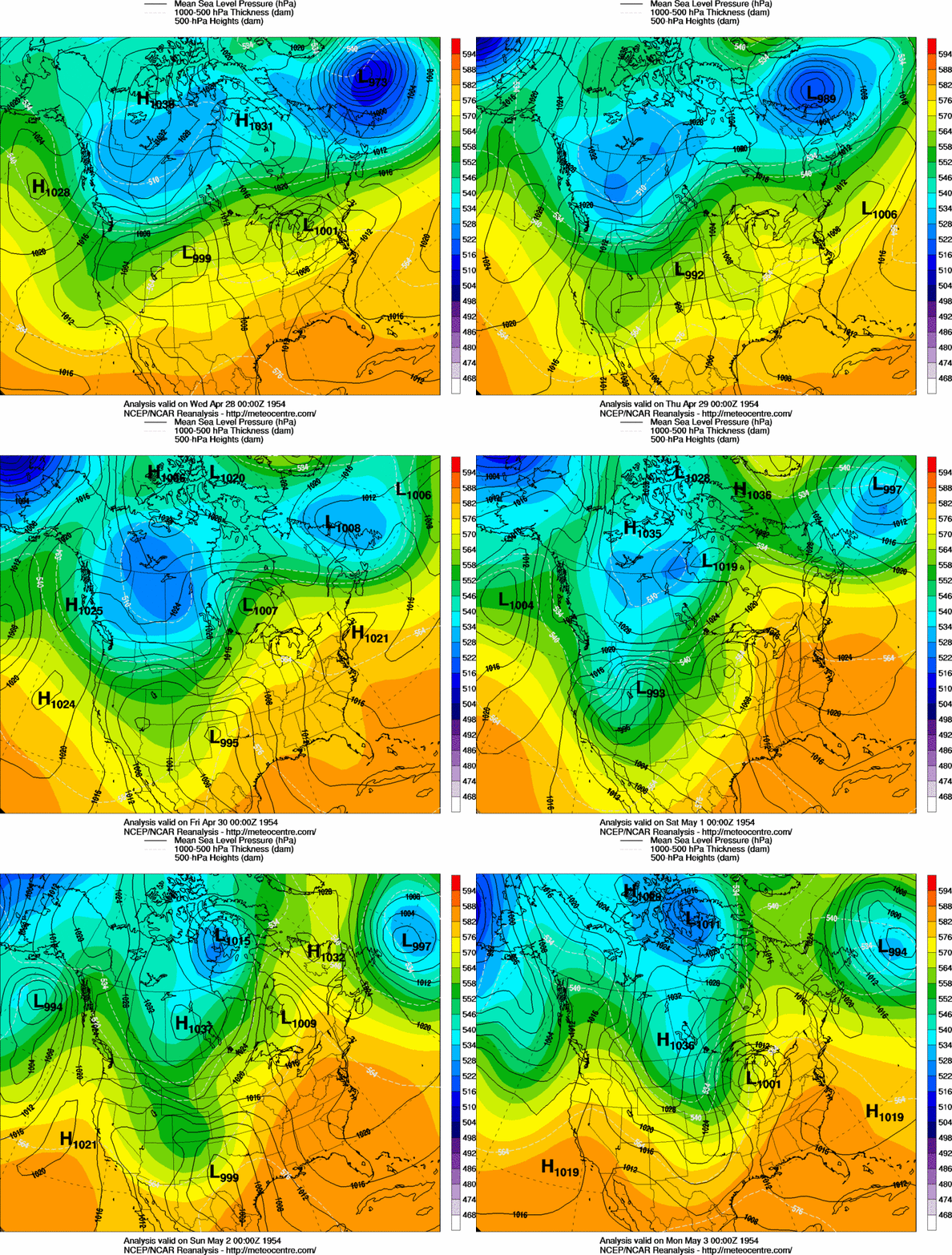
 12 AM CST, April 28, 1954 |
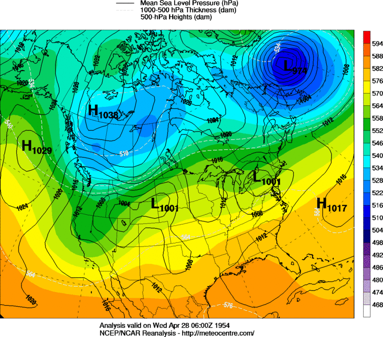
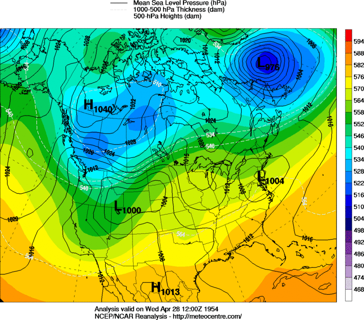 6 AM CST, April 28, 1954 |
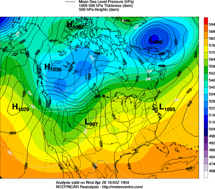 12 PM CST, April 28, 1954 |
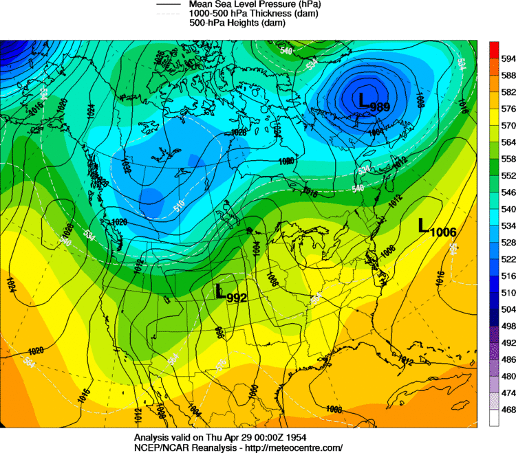 6 PM CST, April 28, 1954 |
 12 AM CST, April 29, 1954 |
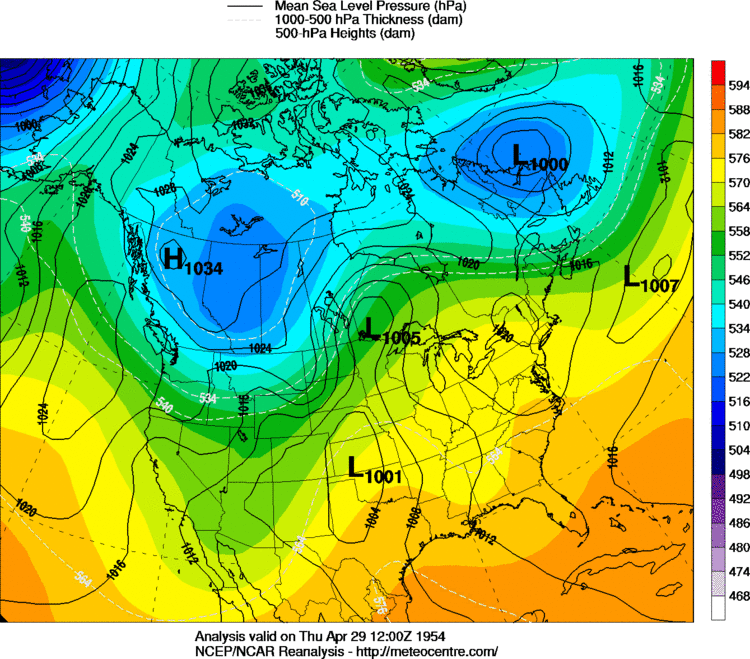 6 AM CST, April 29, 1954 |
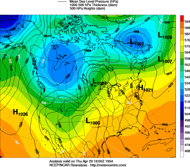 12 PM CST, April 29, 1954 |
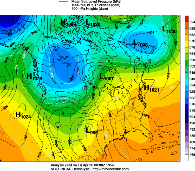 6 PM CST, April 29, 1954 |
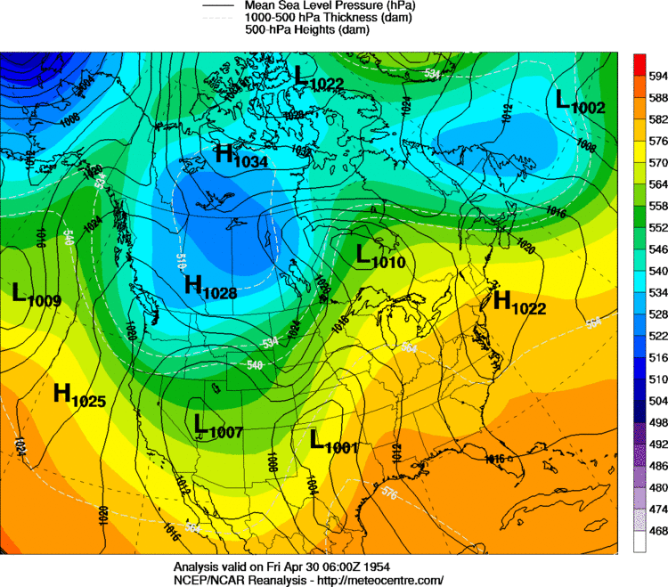 12 AM CST, April 30, 1954 |
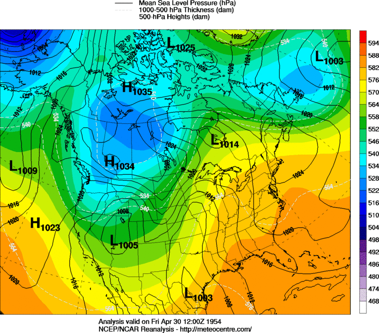 6 AM CST, April 30, 1954 |
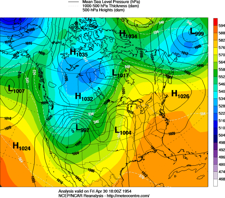 12 PM CST, April 30, 1954 |
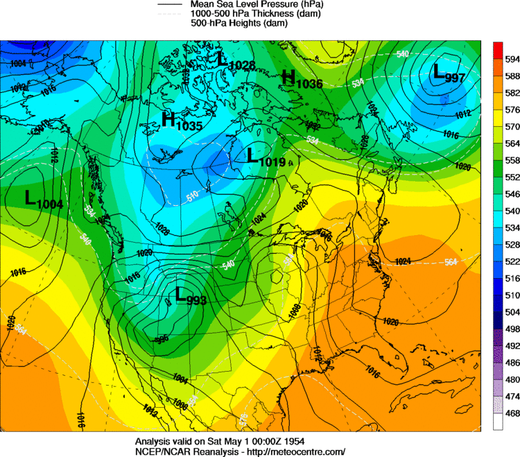 6 PM CST, April 30, 1954 |
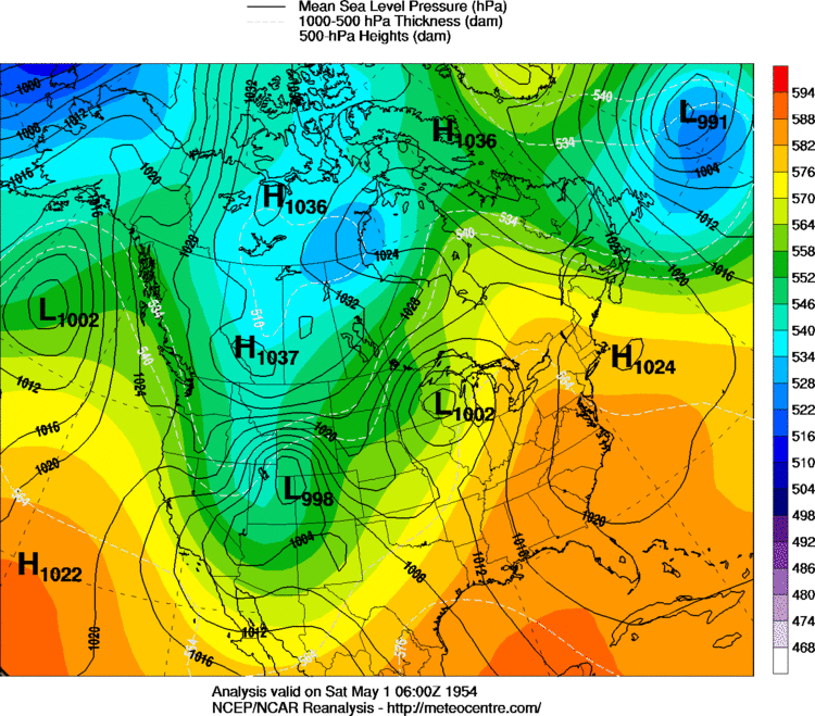 12 AM CST, May 1, 1954 |
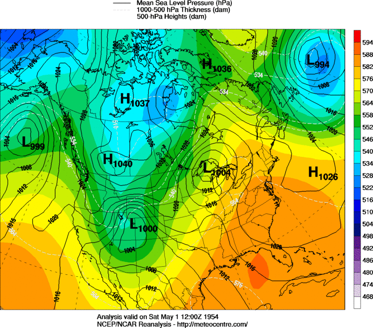 6 AM CST, May 1, 1954 |
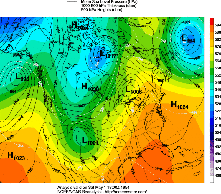 12 PM CST, May 1, 1954 |
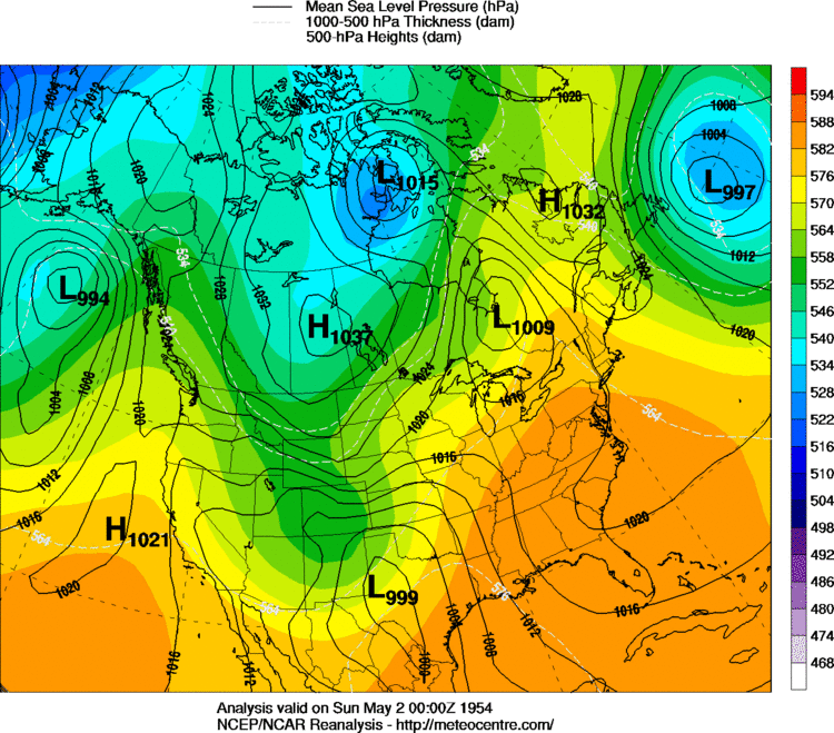 6 PM CST, May 1, 1954 |
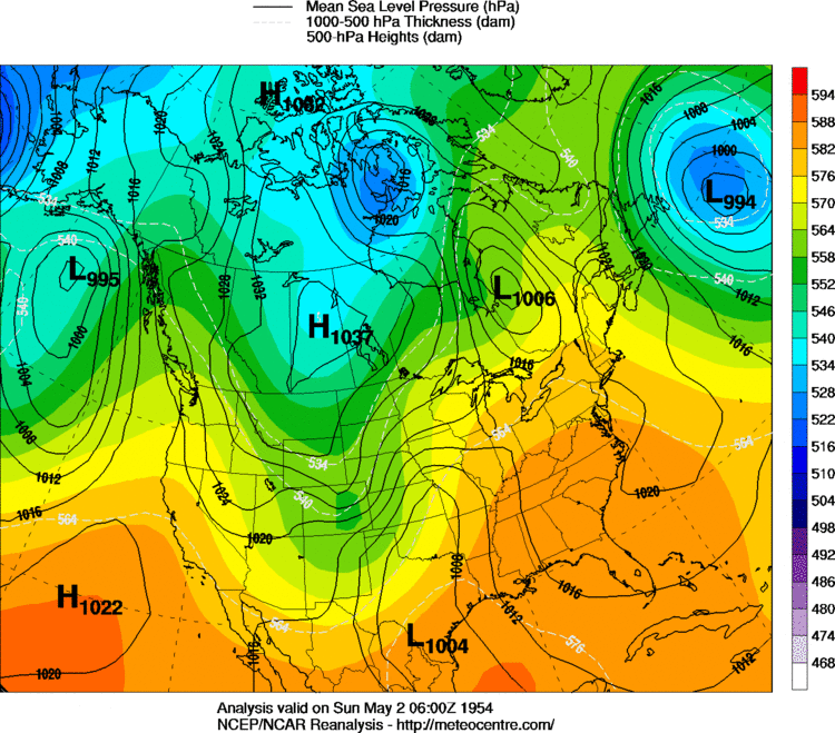 12 AM CST, May 2, 1954 |
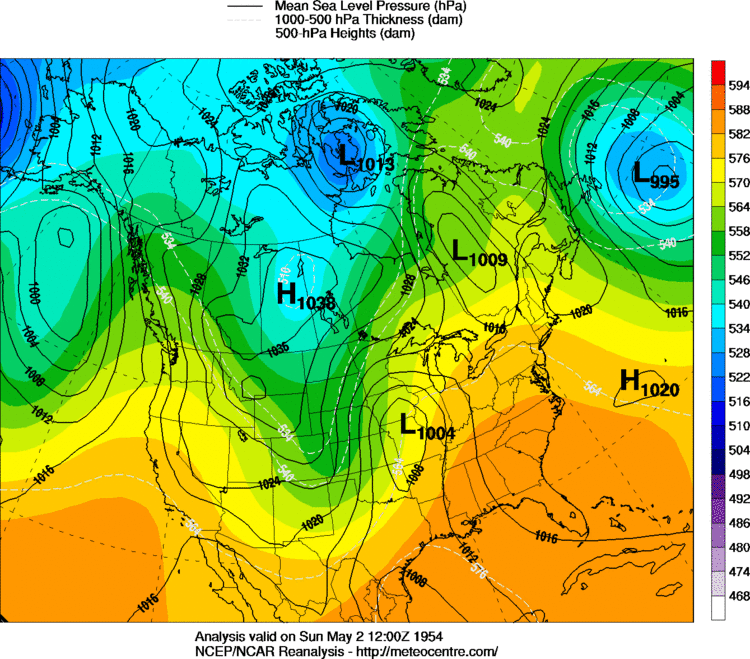 6 AM CST, May 2, 1954 |
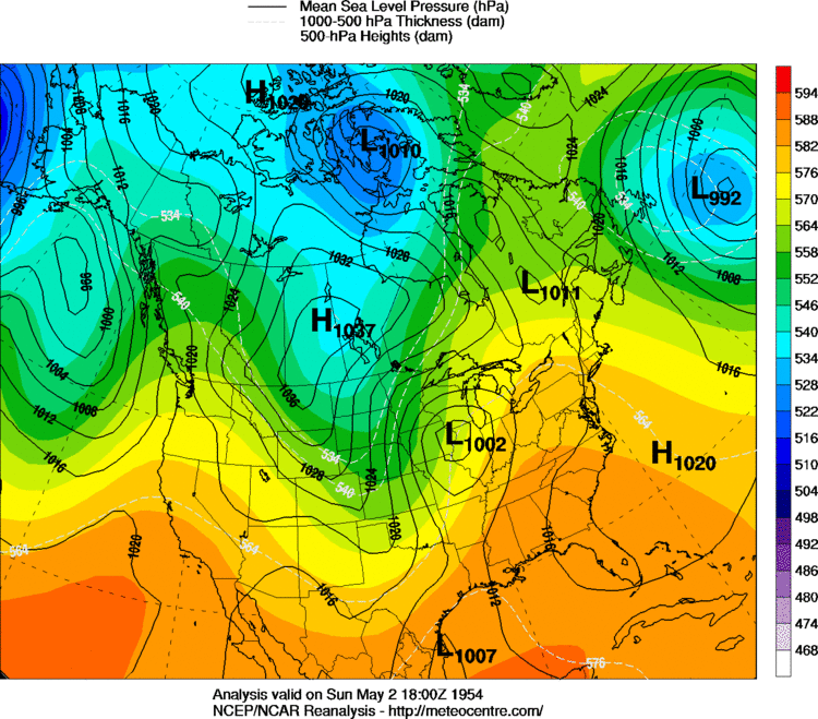 12 PM CST, May 2, 1954 |
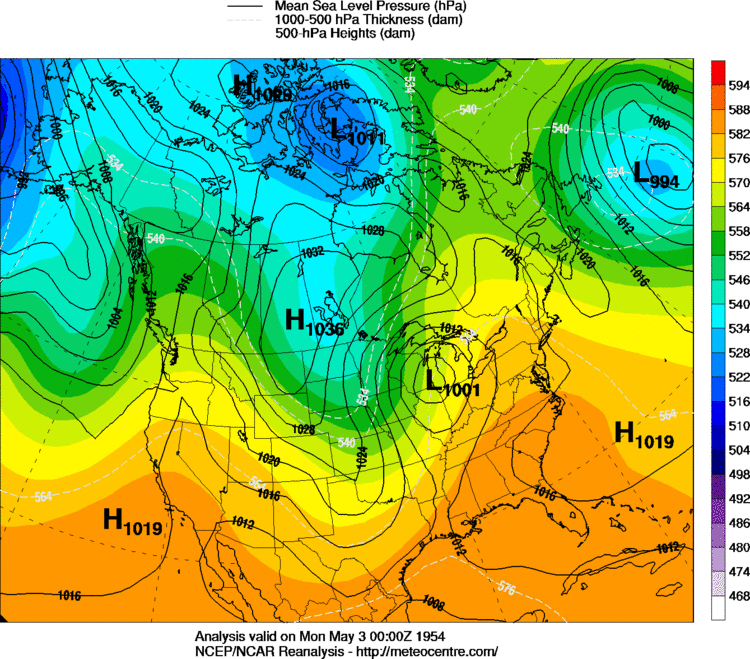 6 PM CST, May 2, 1954 |