Heavy rainfall, coupled excessive runoff in various sections of Oklahoma, characterized the state's weather during the latter third of June 1948, and produced significant or major flooding in some areas of the region. The first in a series of torrential downpours during the 10-day period occurred during the night of June 20-21, 1948 in east-central Oklahoma when storm total rainfall amounts were in excess of 7 inches at Shawnee and Prague, with 6 inches being reported at Wetumka. Lesser though heavy amounts fell at a number of other stations in the region.
The heavy rainfall events continued, spreading into northeastern Oklahoma on June 22-24, 1948, and causing severe local flooding for some areas. Amounts in excess of 5 inches were recorded on June 22nd at Mannford, Nowata, and Vinita in the northeastern section of the state, and at several east-central stations on June 23rd. The resulting floods were especially severe at Okmulgee where the 4-day rainfall from June 21-24 totaled 14.25 inches. About 600 people were evacuated from lowlands along Okmulgee Creek in Okmulgee.
Sharp rises and flooding resulted along the North Canadian, Canadian, and Deep Fork Rivers. The Deep Fork River at Dewar, OK, approached within 1.5 feet of the record stage of 26.67 feet reached in 1945. Additional light to heavy rain occurred again in this region from the June 26-29. The total rainfall during the latter third of the month in this area ranged from 6 to 15 inches. Okmulgee, OK, reported 14.25 inches during the first 4 days, and cooperative observers at Wetumka and Wewoka, OK, recorded 11 to 12 inches.
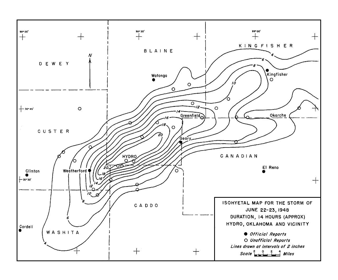 Storm Total Rainfall Map for the June 22-23, 1948 Flash Flood in the Hydro, Oklahoma Area |
The same storm system that brought heavy rainfall to the eastern portions of the state produced even heavier and catastrophic rainfall totals in southern Blaine County and northern Caddo County. A field survey ("bucket survey") conducted by officials from the U.S. Weather Bureau and the Bureau of Reclamation documented unofficial measurements and reports of rainfall totals of 15-20 inches occurring in a 14-hour stretch from the midafternoon hours of June 22nd through the mid-morning hours of June 23rd. The heaviest official rainfall total for this event was 11.25 inches at the cooperative observer site in Geary, and that rainfall occurred between 4:30 pm CST on June 22nd and 7:00 am CST on June 23rd. In the center of the most intense rainfall, estimates based on unofficial measurements indicated most of the rainfall occurred during an 8- to 12-hour period and ranged up to 20 inches in accumulation.
The resulting flash flooding and then river flooding was especially severe along Deer Creek near the town of Hydro where rapidly rising waters trapped or washed away multiple vehicles along U.S. Highway 66 and drowned 11 people. Some newspaper reports indicated that 50 or more vehicles were trapped along Route 66 during the flash flood event. Severe flooding from this heavy rainfall also occurred at Kingfisher, where floodwaters from both Kingfisher and Uncle John creeks reached the tops of cars parked on some streets. Many people in Kingfisher were forced to evacuate, and the resulting property losses reached $250,000. Kingfisher Creek crested at 25.9 feet, 5.9 feet above flood stage, making it the third highest crest all time. Uncle John Creek crested at 25.2 feet, 4.2 feet above flood stage, which was the second highest crest ever recorded at that site.
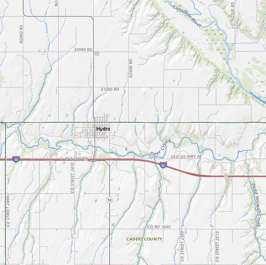 Shaded Relief Map of the Hydro, Oklahoma Area |
In addition to the intense local flash flooding along Deer, and Kingfisher, and Uncle John creeks, sharp rises occurred on both the North Canadian and Canadian Rivers, with the gage site at El Reno cresting at 20.16 feet, which was 3.16 feet above the current flood stage and occurred about 24 hours after the passage of the storm system. The heavy flow caused considerable flooding of lowlands around Yukon and Oklahoma City on the North Canadian River, and from Union City to below Whitefield on the Canadian River. A crest of 13.0 feet on June 23, 1948 at the Union City gaging station exceeded flood stage by 6 feet, and was the fifth highest crest of record. The crest at Calvin, also on the Canadian River, was 22.2 feet on June 24, 1948, exceeded flood stage by 2.2 feet, and made it the ninth highest crest of all time for that location. Downstream of Calvin, a record crest of 20.8 feet on June 28, 1948 at Whitefield, OK exceeded by 3 feet the previous record high stage of 17.75 feet on May 6, 1941.
At the time, the June 22-23, 1948 "Hydro" rainfall event was likely the second heaviest to ever be recorded in Oklahoma. Through 1948, the record rainfall event occurred on September 4, 1940 in southern Pawnee County between Maramec and Hallett. Unofficial measurements, investigated and approved by the Division of Water Resources of the Oklahoma Planning and Resources Board, indicated a maximum rainfall total of 24 inches in a 10-hour period. The greatest 24-hour total at an official cooperative observer site during the 1940 event was 15.50 inches at Sapulpa on September 3-4, 1940. This record stood as the state record for a 24-hour total until it was exceeded by a 24-hour measured total of 15.68 inches at Enid on October 11, 1973.
Another area of heavy rainfall and flooding was centered over the Oklahoma Panhandle and the extreme northwestern portion of Oklahoma. Rainfall totals ranged from 1 to nearly 4 inches on June 24-27, 1948, and caused the North Canadian River to crest at 9.55 feet, or about 0.5 feet lower than the flood stage of 10 feet at Woodward, OK. More thunderstorms and showers dropped lesser amounts of rain elsewhere on June 25-29, 1948, but these additional amounts prolonged the floodwaters and flood threats in several areas.
Preliminary data indicated that about $1.67 million in flood damages resulted along the Arkansas and Cimarron rivers and their tributaries, and more than $2.75 million in damages were incurred along the Canadian and North Canadian rivers and their tributaries. In addition to the extensive flood damage to buildings, highways, and crops, enormous soil erosion losses also occurred.
This event was another in a series of heavy rainfall/flood events that plagued the region during the first half of the 20th century, and lead to significant flood control efforts in the United States during the latter half of the century.
The following map was created by stitching together 3 USGS topographic maps that were produced in the late 1970s through the mid 1980s. The map shows the Deer Creek basin including numerous smaller creeks that feed into Deer Creek just south of the town of Hydro, Oklahoma. The lower third of the map shows the current U.S. Interstate Highway 40 (I-40). I-40 runs parallel to and just south of Deer Creek. The highlighted yellow line between Deer Creek and I-40 shows the location of the former U.S. Highway 66.
All 11 of the flash flood deaths occurred in areas along the former U.S. Highway 66 where flash flooding swamped multiple vehicles and left many people temporarily stranded by the floodwaters. High flows also occurred in the Canadian River near the confluence with it and Deer Creek, and likely caused backwater issues on Deer Creek, leading to a slower recession on the creek and an extended waiting and rescue times for Route 66 travelers trapped by the floodwaters.
The topographic maps used to create this map were accessed via the USGS Topoview website. More recent topographic maps based on updated data and information can also be found via this USGS website.
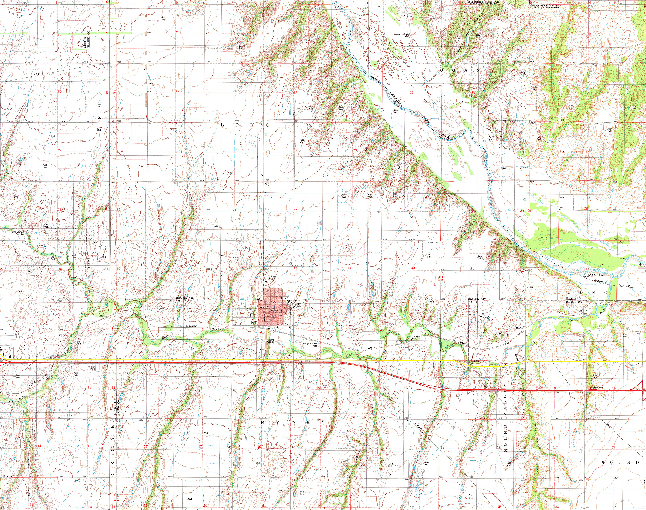 Composite Map Based on USGS Topo Maps in the Hydro, Oklahoma Area |
This aerial map shows Deer Creek and the numerous smaller creeks (including Little Deep Creek and Dead Woman Creek) that feed into it near Hydro, OK. The map also shows U.S. Interstate Highway 40 (I-40)and the yellow line indicates where the former U.S. Highway 66 is located.
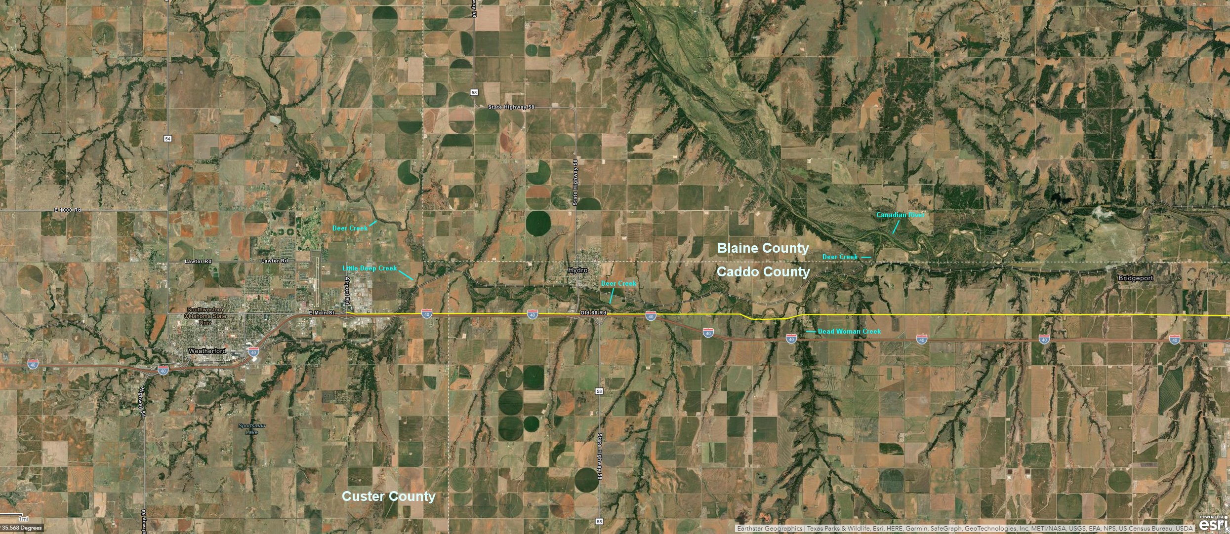 Aerial Map of the Hydro, Oklahoma Area |
This photo shows a view looking west at the former U.S. Highway 66 about 2 miles east-southeast of Hydro, OK. The Route 66 bridge spans a small creek that feeds into Deer Creek just north of the the road and bridge. The tree line shown in the right side (north) of the photo is located along Deer Creek. U.S. Highway 66 was constructed in this area of Oklahoma during the early 1930s, and a lot of the original road still exists in the Hydro, OK area. U.S. Highway 66 was decommissioned in 1985.
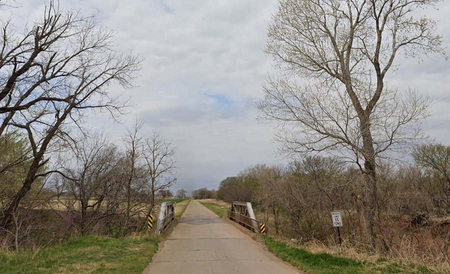 View looking west at Former U.S. Highway 66 near Hydro, Oklahoma. |
The following photos were taken by USDA/Soil Conservation Service (now Natural Resources Conservation Service)personnel on July 9 and 20, 1948. These photos show severe erosion caused by heavy rainfall and runoff from severe thunderstorms on June 22-23, 1948.
The heavy runoff created devastating flash flooding in the Hydro, Oklahoma area and within the Deer Creek basin. Storm total rainfall amounts totaled 16-20 inches in and near the town of Hydro, and most of the rain fell within 7-14 hours from the late afternoon and evening on June 22nd, and the early morning hours of June 23rd.
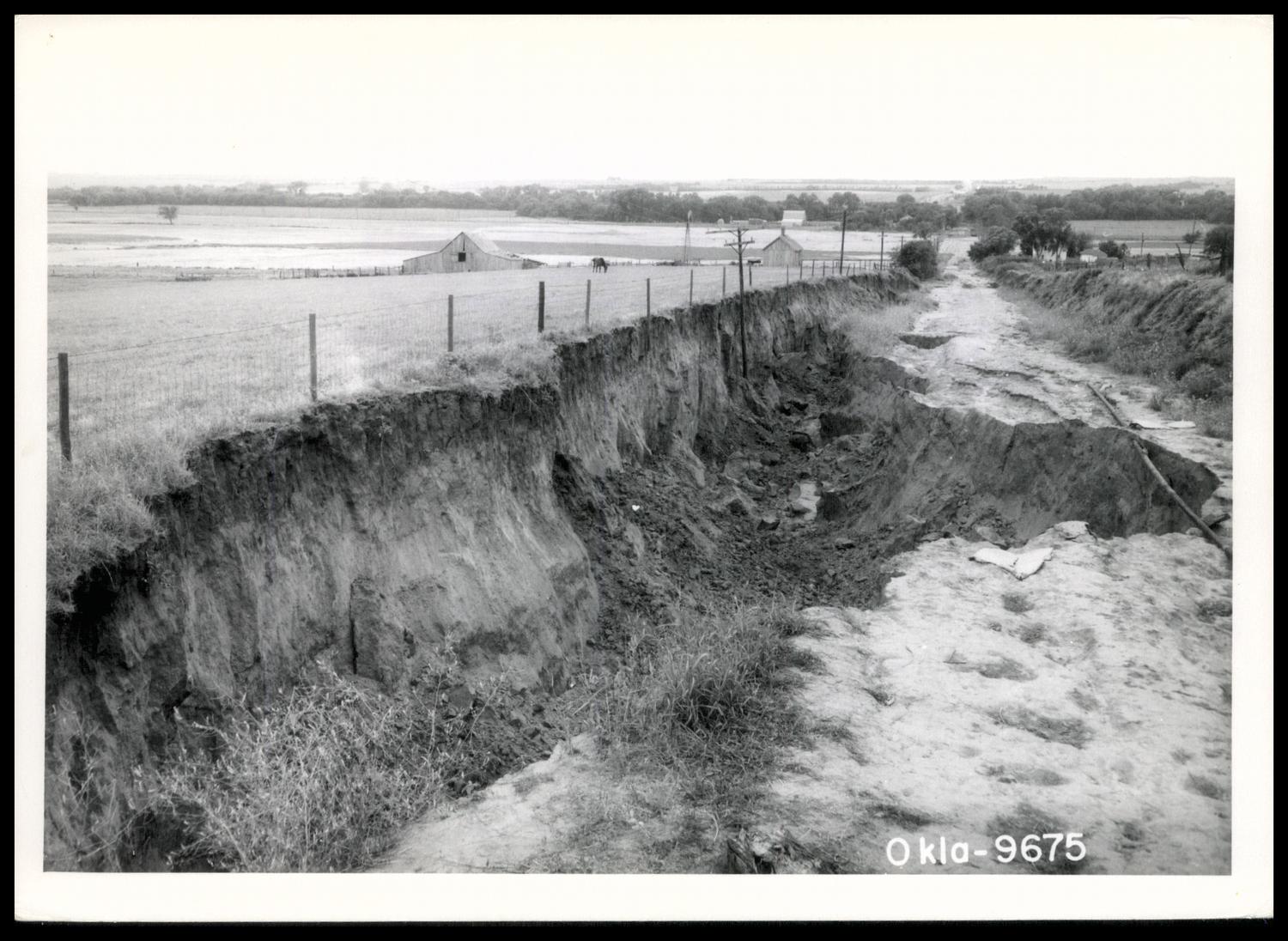 Gully Caused by Erosion Along a Rural Road near Hydro, Oklahoma on June 22-23, 1948. The gully seen in these photos was 25 feet deep, 40 feet wide, and several blocks long, as was located near Hydro, OK. This gully occurred along what was a well-traveled, rural road. Less than 2 acres of land drained into the gully above its head. |
Credit: Reid, Louis. Water Conservation; Water Erosion; Flooding and Prevention, photograph, July 9, 1948; (https://gateway.okhistory.org/ark:/67531/metadc1771945/: accessed June 21, 2023), The Gateway to Oklahoma History, https://gateway.okhistory.org; crediting Oklahoma Conservation Historical Society.
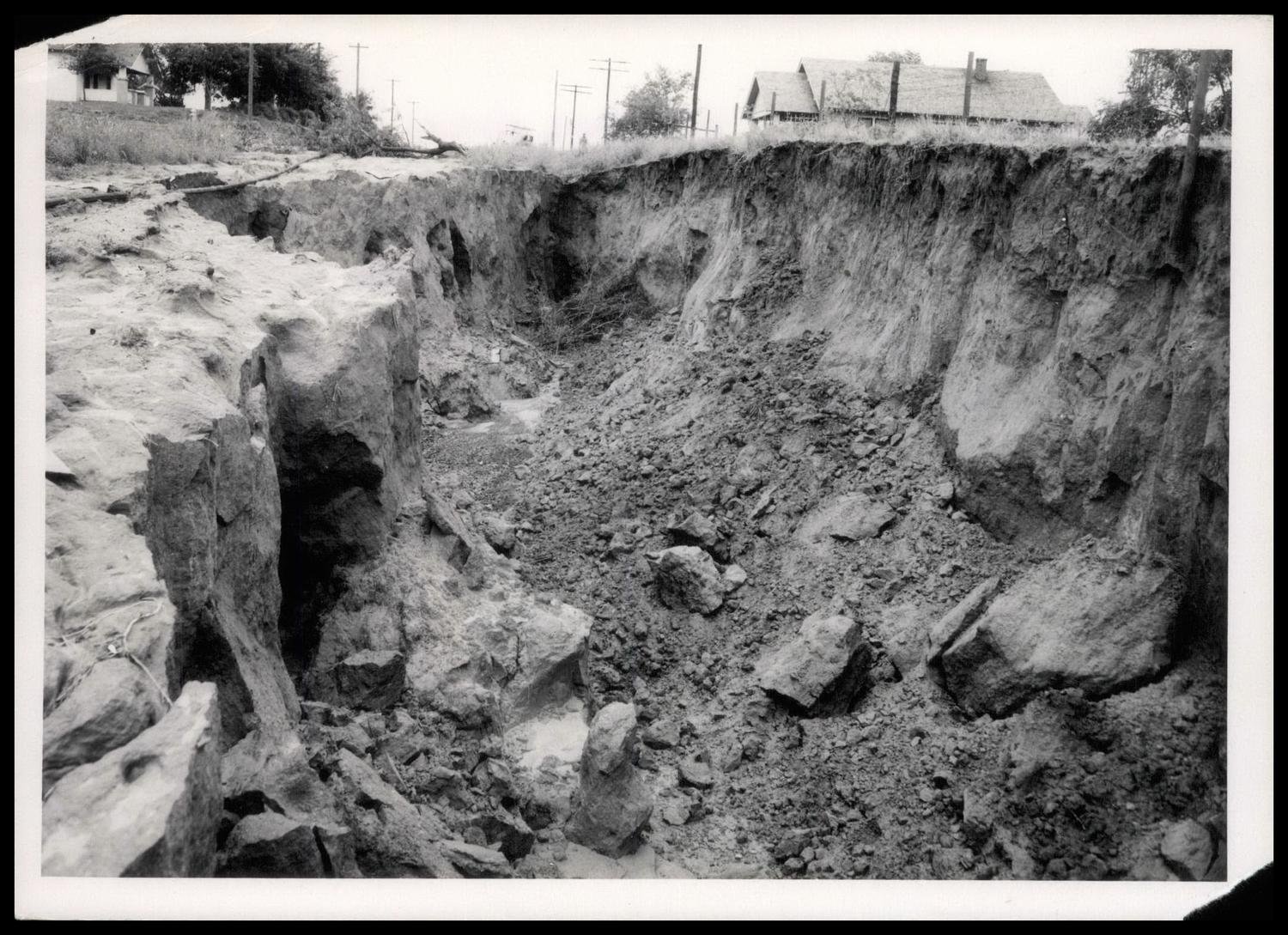 Gully Caused by Erosion Along a Rural Road near Hydro, Oklahoma on June 22-23, 1948. The gully seen in these photos was 25 feet deep, 40 feet wide, and several blocks long, as was located near Hydro, OK. This gully occurred along what was a well-traveled, rural road. Less than 2 acres of land drained into the gully above its head. |
Credit: Reid, Louis. Water Conservation; Water Erosion; Flooding and Prevention, photograph, July 9, 1948; ((https://gateway.okhistory.org/ark:/67531/metadc1771947/: accessed June 21, 2023), The Gateway to Oklahoma History, https://gateway.okhistory.org; crediting Oklahoma Conservation Historical Society.
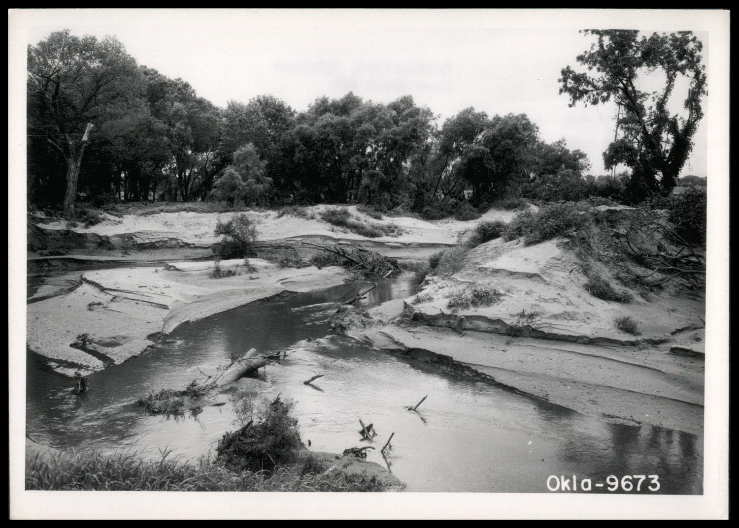 This photo shows a deposit of sterile sand along Deer Creek and just south of Hydro, Oklahoma. Most of this sand was deposited here by floodwaters on June 22, 1948. |
Credit: Reid, Louis E. Sterile Sand on Deer Creek, photograph, July 9, 1948; (https://gateway.okhistory.org/ark:/67531/metadc1934723/: accessed June 21, 2023), The Gateway to Oklahoma History, https://gateway.okhistory.org; crediting Oklahoma Conservation Historical Society.
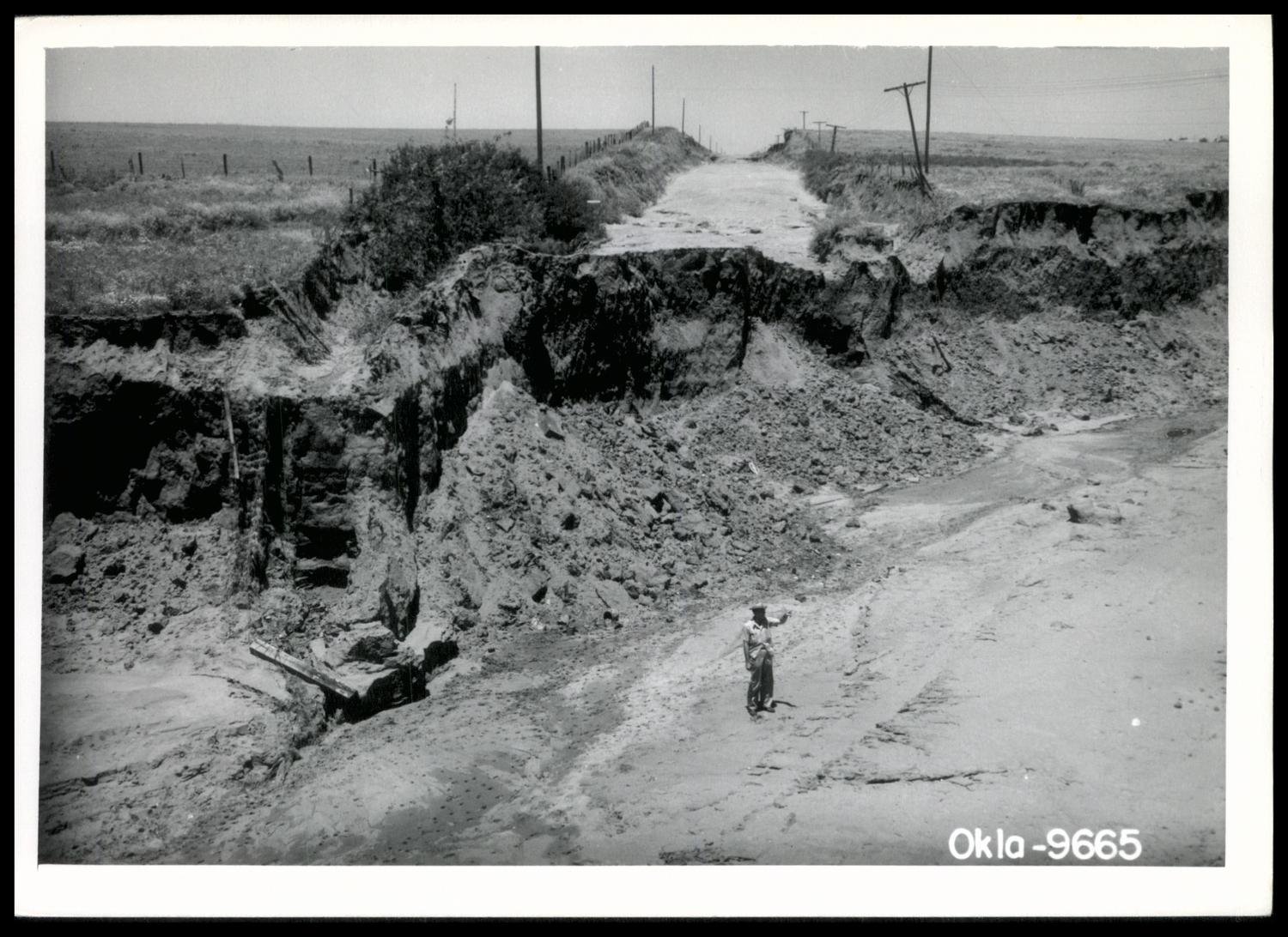 This photo shows a washed out section line road that ran north from Hydro, Oklahoma. This road and a concrete culvert were washed away by flash flooding produced from 16 to 20 inches of rainfall on June 22-23, 1948. Many farm families had to drive many miles out of the way to reach the town of Hydro. The extent of the washout was indicated by the Soil Conservation Service technician standing in the lower middle of the photo. |
Credit: Fox, Lester C. Section Line Road and Concrete Structure Swept Away By 16-20 Inch Rain, photograph, July 20, 1948; (https://gateway.okhistory.org/ark:/67531/metadc1926854/: accessed June 21, 2023), The Gateway to Oklahoma History, https://gateway.okhistory.org; crediting Oklahoma Conservation Historical Society.
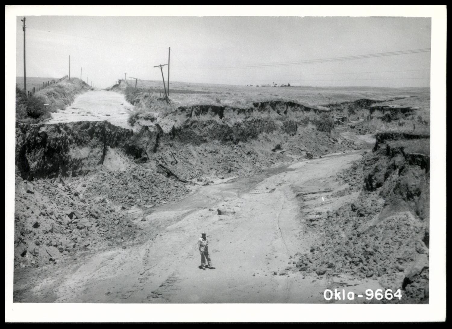 This photo also shows a washed out section line road that ran north from Hydro, Oklahoma with the view shifted slightly to the northeast from the previous photo. This road and a concrete culvert were washed away by flash flooding produced from 16 to 20 inches of rainfall on June 22-23, 1948. Many farm families had to drive many miles out of the way to reach the town of Hydro. The extent of the washout was indicated by the Soil Conservation Service technician standing in the lower middle of the photo. |
Credit: Fox, Lester C. Section Line Road and Concrete Structure Swept Away By 16-20 Inch Rain, photograph, July 20, 1948; (https://gateway.okhistory.org/ark:/67531/metadc1926855/: accessed June 21, 2023), The Gateway to Oklahoma History, https://gateway.okhistory.org; crediting Oklahoma Conservation Historical Society.
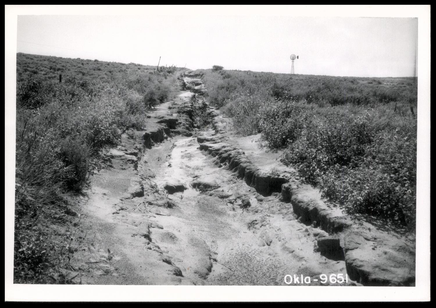 This photo shows what was a well-traveled section line road prior to 4 pm CST on June 22, 1948. By the early morning hours of June 23rd, severe erosion produced significant damage to this road and made it impassable. |
Fox, Lester. Water Conservation; Water Erosion; Flooding and Prevention, photograph, July 20, 1948; (https://gateway.okhistory.org/ark:/67531/metadc1935728/: accessed June 21, 2023), The Gateway to Oklahoma History, https://gateway.okhistory.org; crediting Oklahoma Conservation Historical Society.
The following table includes 11-day storm total precipitation amounts from June 20-30, 1948 for locations in 48 counties in western/central Oklahoma and 8 counties in western north Texas. Daily report times for the cooperative observers varied in 1948, with some observers reporting around 7 am and others reporting from 5-7 pm.
| Central and Western Oklahoma | ||||||||||||||
| Location | County | State | 6/20 | 6/21 | 6/22 | 6/23 | 6/24 | 6/25 | 6/26 | 6/27 | 6/28 | 6/29 | 6/30 | Total |
|---|---|---|---|---|---|---|---|---|---|---|---|---|---|---|
| Cherokee | Alfalfa | OK | 0.48 | T | 0.00 | 0.00 | 0.47 | 0.05 | 0.74 | 1.70 | 0.04 | 0.00 | 0.00 | 3.48 |
| Great Salt Plains Dam | Alfalfa | OK | 0.00 | 0.33 | 0.57 | T | T | 0.29 | 0.29 | 1.95 | 1.29 | T | 0.00 | 4.72 |
| Helena | Alfalfa | OK | 0.16 | 0.21 | 0.00 | 0.00 | 0.00 | 0.03 | 0.00 | 0.82 | 1.49 | 0.00 | 0.00 | 2.71 |
| Atoka | Atoka | OK | 0.00 | 0.00 | 0.00 | 5.00 | 0.02 | 0.00 | 0.00 | 0.11 | 0.52 | 0.14 | 0.00 | 5.79 |
| Caney | Atoka | OK | 0.00 | 0.00 | 0.00 | 0.00 | 4.40 | 0.00 | 0.20 | T | T | 0.30 | 0.00 | 4.90 |
| Daisy | Atoka | OK | 0.00 | T | T | 1.96 | 2.01 | 0.00 | T | 0.00 | 0.00 | 0.19 | 0.00 | 4.16 |
| Farris | Atoka | OK | 0.00 | 0.00 | 0.00 | 0.00 | 3.47 | 0.99 | 0.00 | 0.00 | 0.03 | 0.19 | 0.00 | 4.68 |
| Elk City | Beckham | OK | 1.29 | 0.35 | 0.00 | 0.03 | 0.00 | 0.81 | 0.13 | 0.60 | 0.13 | 0.00 | 0.00 | 3.34 |
| Erick | Beckham | OK | 0.53 | 2.61 | 0.03 | T | 0.00 | 0.00 | 0.60 | 0.00 | 0.70 | 0.00 | 0.00 | 4.47 |
| Sayre | Beckham | OK | 0.75 | 1.50 | 1.00 | 0.00 | 0.00 | 0.00 | 0.75 | 0.00 | 0.65 | 0.00 | 0.00 | 4.65 |
| Canton | Blaine | OK | 0.21 | 0.11 | 0.29 | 0.43 | 0.00 | 0.00 | 0.00 | 0.31 | 0.30 | 1.02 | 0.00 | 2.67 |
| Canton Dam | Blaine | OK | 0.31 | 0.02 | 0.28 | T | T | 0.00 | 0.80 | 0.35 | 1.05 | 0.06 | 0.00 | 2.87 |
| Geary | Blaine | OK | 0.00 | 0.72 | 1.21 | 11.25 | 0.15 | 0.00 | 0.16 | 0.80 | 0.27 | 0.10 | 0.00 | 14.66 |
| Okeene | Blaine | OK | 0.11 | 0.00 | 0.72 | 0.26 | 0.00 | 0.00 | 0.60 | 0.39 | 1.11 | 0.00 | 0.12 | 3.31 |
| Watonga | Blaine | OK | 0.00 | 0.00 | 1.11 | 1.98 | 0.00 | 0.10 | 0.18 | 1.17 | 0.23 | 0.00 | 0.00 | 4.77 |
| Durant | Bryan | OK | 0.00 | 0.00 | 0.00 | 0.00 | 1.80 | 0.11 | 0.08 | 0.09 | 0.14 | 0.33 | 0.00 | 2.55 |
| Yuba | Bryan | OK | 0.00 | 0.00 | 0.00 | 0.00 | 1.35 | 0.00 | T | 0.25 | 0.55 | 0.00 | 0.00 | 2.15 |
| Anadarko | Caddo | OK | 0.31 | 2.49 | 0.16 | 0.95 | 0.14 | T | 0.12 | 0.00 | 0.41 | 0.00 | 0.00 | 4.58 |
| Apache | Caddo | OK | 0.09 | 1.65 | T | 0.97 | 0.00 | 0.00 | 0.00 | T | 0.52 | 0.00 | 0.00 | 3.23 |
| Carnegie | Caddo | OK | 0.00 | 0.29 | 0.69 | 0.70 | 0.31 | T | 0.04 | 0.03 | 0.50 | 0.10 | 0.00 | 2.66 |
| Fort Cobb | Caddo | OK | 0.49 | 1.62 | 0.00 | 1.06 | 0.03 | 0.00 | 1.17 | 0.00 | 0.49 | 0.00 | 0.00 | 4.86 |
| Lookeba | Caddo | OK | 0.00 | 0.41 | 1.32 | 1.24 | 0.38 | 0.56 | 0.11 | 0.00 | 0.38 | 0.00 | 0.05 | 4.45 |
| El Reno | Canadian | OK | 0.00 | 0.37 | 1.75 | 1.35 | 1.80 | 0.00 | 0.00 | 0.48 | 0.19 | 0.33 | 0.00 | 6.27 |
| Fort Reno | Canadian | OK | 0.00 | 0.53 | 1.11 | 1.06 | 1.64 | 0.01 | 0.24 | 0.87 | 0.20 | 0.28 | 0.00 | 5.94 |
| Union City | Canadian | OK | 0.00 | 0.73 | 2.10 | 0.75 | 1.10 | 0.00 | 0.00 | 0.25 | 0.35 | 0.00 | 0.00 | 5.28 |
| Ardmore | Carter | OK | 0.00 | T | 0.00 | 0.00 | T | 3.72 | 0.94 | T | 1.37 | 0.01 | 0.00 | 6.04 |
| Ardmore Airport | Carter | OK | 0.00 | T | T | 2.05 | 0.55 | 0.02 | 0.43 | 0.11 | 1.04 | 0.00 | 0.00 | 4.20 |
| Healdton | Carter | OK | 0.00 | 0.00 | 0.00 | 1.20 | 1.10 | T | 0.30 | 0.80 | 0.30 | T | 0.00 | 3.70 |
| Norman | Cleveland | OK | T | 2.74 | 0.81 | 1.28 | 1.10 | 0.00 | 0.00 | 0.13 | 0.23 | 0.00 | 0.00 | 6.29 |
| Norman - University of Oklahoma | Cleveland | OK | 0.00 | 3.05 | 0.73 | 0.88 | 0.63 | 0.02 | 0.17 | 0.00 | 0.24 | 0.19 | 0.00 | 5.91 |
| Coalgate | Coal | OK | 0.00 | 0.00 | 0.00 | 0.00 | 4.50 | 0.00 | T | 0.00 | 0.58 | 0.13 | 0.00 | 5.21 |
| Lehigh | Coal | OK | 0.00 | 0.00 | 0.00 | 0.00 | 6.85 | 0.00 | 0.13 | 0.00 | 0.44 | 0.00 | 0.00 | 7.42 |
| Chattanooga | Comanche | OK | 0.00 | 0.45 | 0.00 | 1.22 | 0.92 | 0.00 | 0.00 | 0.00 | 0.84 | 0.24 | 0.00 | 3.67 |
| Lawton | Comanche | OK | 0.00 | 0.93 | 0.00 | 0.20 | 0.85 | 0.00 | 0.18 | 0.00 | 0.59 | 0.62 | 0.00 | 3.37 |
| Lawton 2 N | Comanche | OK | 0.00 | 1.06 | 0.00 | 0.38 | 0.55 | 0.00 | 0.15 | 0.00 | 0.53 | 0.18 | 0.00 | 2.85 |
| Wichita Mountains WLR | Comanche | OK | 0.10 | 1.58 | 0.00 | 1.51 | 0.10 | 0.00 | 0.05 | 0.60 | 0.02 | 0.00 | 0.00 | 3.96 |
| Randlett | Cotton | OK | 0.00 | 0.00 | 0.00 | 1.78 | 0.29 | T | 0.53 | 0.00 | 0.79 | 0.00 | 0.00 | 3.39 |
| Walters | Cotton | OK | 0.00 | 0.37 | 0.03 | 1.58 | 0.10 | 0.00 | 0.03 | 0.00 | 0.70 | 0.00 | 0.00 | 2.81 |
| Anthon | Custer | OK | 0.65 | 0.05 | 0.00 | 0.05 | 0.00 | 1.35 | 0.20 | 1.15 | 0.10 | 0.00 | 0.00 | 3.55 |
| Clinton | Custer | OK | 0.05 | 0.10 | 1.36 | 1.10 | 0.00 | 0.22 | 0.20 | 0.03 | 0.50 | 0.00 | 0.00 | 3.56 |
| Weatherford | Custer | OK | 0.00 | 0.81 | 3.40 | 7.51 | 0.19 | 0.00 | 0.04 | 0.09 | 0.95 | 0.00 | 0.00 | 12.99 |
| Camargo | Dewey | OK | 0.67 | 0.12 | 0.00 | 0.00 | T | 0.88 | 0.00 | 0.40 | 1.48 | 0.00 | 0.00 | 3.55 |
| Oakwood | Dewey | OK | 0.25 | 0.59 | 0.92 | 0.00 | 0.00 | 0.00 | 0.59 | 0.29 | 1.32 | 0.00 | 0.00 | 3.96 |
| Taloga | Dewey | OK | 0.18 | 0.10 | 0.02 | 0.00 | 0.00 | 0.00 | 0.72 | 0.36 | 1.40 | 0.11 | 0.00 | 2.89 |
| Arnett | Ellis | OK | 0.70 | T | 0.00 | 0.00 | 0.00 | 0.00 | 0.60 | 0.30 | 0.22 | T | 0.00 | 1.82 |
| Gage Airport | Ellis | OK | 1.00 | 0.00 | 0.00 | 0.00 | T | 0.64 | 0.06 | 2.35 | 0.00 | 0.00 | 0.00 | 4.05 |
| Shattuck | Ellis | OK | 0.54 | 0.27 | 0.00 | 0.00 | 0.00 | 0.00 | 0.00 | 1.75 | 0.86 | 0.00 | 0.00 | 3.42 |
| Enid | Garfield | OK | 0.03 | 0.62 | 0.58 | 0.02 | 0.00 | 0.00 | 0.53 | 0.15 | 1.60 | 0.02 | 0.00 | 3.55 |
| Garber | Garfield | OK | 0.06 | 1.56 | 1.47 | 0.00 | 0.00 | 0.00 | 2.00 | 1.86 | 0.00 | 0.23 | 0.00 | 7.18 |
| Kremlin | Garfield | OK | 0.16 | 0.31 | 0.35 | 0.55 | T | 0.00 | 0.61 | 0.56 | 1.15 | 0.00 | 0.00 | 3.69 |
| Waukomis | Garfield | OK | 0.51 | 0.90 | 1.10 | 0.19 | 0.07 | 0.00 | 0.50 | 0.15 | 1.85 | 0.00 | 0.00 | 5.27 |
| Elmore City | Garvin | OK | 0.35 | 0.00 | 0.00 | 3.21 | T | 0.00 | 0.13 | 0.23 | 1.24 | 0.09 | 0.00 | 5.25 |
| Hennepin | Garvin | OK | 0.00 | 0.14 | 0.00 | 0.00 | 2.05 | 1.32 | 0.00 | 0.17 | 0.67 | 0.00 | 0.00 | 4.35 |
| Lindsay | Garvin | OK | 0.00 | 2.10 | 0.00 | 0.20 | 2.07 | 0.05 | 0.45 | 0.00 | 0.00 | 0.50 | 0.00 | 5.37 |
| Paoli | Garvin | OK | 0.45 | 1.54 | 0.00 | 1.08 | 1.55 | 0.00 | 0.26 | 0.32 | 0.50 | 0.00 | 0.00 | 5.70 |
| Pauls Valley | Garvin | OK | 0.00 | 0.33 | 0.01 | 0.15 | 2.56 | 0.05 | 0.53 | 0.32 | 1.30 | 0.02 | 0.00 | 5.27 |
| Chickasha | Grady | OK | 0.00 | 2.91 | 1.93 | 0.71 | 0.71 | T | 0.00 | 0.12 | 0.36 | 0.07 | 0.00 | 6.81 |
| Ninnekah | Grady | OK | 1.32 | 2.06 | 0.00 | 0.91 | 1.15 | 0.00 | 0.00 | 0.12 | 0.37 | 0.00 | 0.00 | 5.93 |
| Jefferson | Grant | OK | 0.15 | 0.07 | 0.27 | 0.00 | 0.03 | 1.27 | 1.10 | 1.29 | 1.12 | 0.00 | 0.00 | 5.30 |
| Mangum | Greer | OK | 0.00 | 0.08 | 0.00 | 0.04 | 0.00 | 0.00 | 0.00 | 0.00 | 0.43 | 0.00 | 0.00 | 0.55 |
| Moravia | Greer | OK | 0.65 | 0.51 | 0.70 | 0.10 | 0.00 | T | 0.08 | T | 0.41 | 0.00 | 0.00 | 2.45 |
| Hollis | Harmon | OK | 0.00 | 0.02 | 0.03 | 0.04 | 0.19 | 0.00 | 0.00 | 0.00 | 0.52 | 0.00 | 0.00 | 0.80 |
| Vinson | Harmon | OK | 0.16 | 0.08 | 0.47 | 0.00 | 0.00 | 0.00 | 0.00 | 0.00 | 0.53 | 0.00 | 0.00 | 1.24 |
| Buffalo | Harper | OK | 1.11 | 0.33 | 0.00 | 0.00 | 0.00 | 0.00 | 1.12 | 0.36 | 2.07 | 0.90 | 0.09 | 5.98 |
| Laverne | Harper | OK | 1.34 | 0.00 | 0.00 | 0.00 | 0.00 | 0.37 | 0.68 | 2.14 | 0.75 | 0.00 | 0.00 | 5.28 |
| Calvin | Hughes | OK | 0.00 | 1.07 | 0.00 | 0.00 | 0.06 | 0.00 | 0.60 | 0.35 | 1.08 | 0.08 | 0.00 | 3.24 |
| Holdenville | Hughes | OK | 0.00 | 5.87 | 0.00 | 4.23 | 0.72 | 0.00 | 1.31 | 0.02 | 0.84 | 0.20 | 0.00 | 13.19 |
| Wetumka | Hughes | OK | 0.00 | 5.94 | 0.20 | 1.00 | 4.78 | 0.00 | 1.37 | 0.15 | 0.43 | 0.13 | 0.00 | 14.00 |
| Altus | Jackson | OK | 0.00 | 0.00 | 0.18 | 1.45 | 0.00 | 0.51 | T | 0.00 | 0.49 | 0.00 | 0.00 | 2.63 |
| Altus 4 N | Jackson | OK | 0.00 | 0.00 | 0.00 | 0.85 | 0.00 | 0.00 | 0.00 | 0.00 | 0.47 | 0.00 | 0.00 | 1.32 |
| Eldorado | Jackson | OK | 0.00 | 0.04 | T | 2.87 | 0.00 | 0.00 | 0.00 | 0.00 | 0.77 | T | 0.00 | 3.68 |
| Waurika | Jefferson | OK | 0.00 | 0.02 | 0.00 | 0.00 | 1.48 | 0.00 | 0.00 | 0.27 | 1.10 | 0.15 | 0.00 | 3.02 |
| Pontotoc | Johnston | OK | 0.00 | 0.00 | 0.00 | 4.80 | 0.00 | 0.00 | 0.00 | 0.00 | 0.00 | 0.00 | 0.00 | 4.80 |
| Tishomingo | Johnston | OK | 0.00 | 0.00 | 0.00 | 3.30 | 1.11 | T | 0.85 | 0.20 | 0.56 | 0.00 | 0.00 | 6.02 |
| Blackwell | Kay | OK | 0.06 | 0.79 | 0.02 | 0.88 | 0.00 | 0.02 | 1.04 | 0.20 | 0.36 | 0.00 | 0.00 | 3.37 |
| Newkirk | Kay | OK | 0.24 | 0.33 | 1.53 | 0.00 | 0.00 | 0.02 | 1.50 | 0.10 | 0.35 | 0.23 | 0.00 | 4.30 |
| Ponca City | Kay | OK | 0.65 | 1.00 | 1.76 | 0.00 | 0.00 | 0.00 | 1.02 | 0.15 | 0.43 | 0.00 | 0.00 | 5.01 |
| Ponca City Airport | Kay | OK | 0.46 | 2.22 | 0.14 | T | 0.05 | 0.62 | 0.39 | 0.54 | 0.01 | 0.00 | 0.00 | 4.43 |
| Hennessey | Kingfisher | OK | 0.40 | 4.55 | 0.29 | 1.24 | 0.06 | 0.00 | 1.37 | 1.79 | 0.24 | 0.00 | 0.00 | 9.94 |
| Kingfisher | Kingfisher | OK | 0.21 | 0.69 | 2.92 | 3.72 | 0.01 | 0.00 | 0.30 | 0.24 | 0.57 | 0.00 | 0.00 | 8.66 |
| Altus Dam | Kiowa | OK | 0.02 | 0.03 | 0.15 | 0.35 | 0.04 | 0.00 | T | 0.00 | 0.48 | 0.00 | 0.00 | 1.07 |
| Hobart | Kiowa | OK | 0.00 | 0.00 | 0.43 | 0.32 | 0.08 | 0.00 | T | 0.00 | 0.50 | 0.00 | 0.00 | 1.33 |
| Snyder | Kiowa | OK | 0.00 | 0.72 | 0.82 | 0.90 | 1.25 | 0.00 | 0.17 | 0.00 | 0.49 | 0.00 | 0.00 | 4.35 |
| Chandler #1 | Lincoln | OK | 0.00 | 2.90 | 1.23 | 3.60 | 0.40 | 0.05 | 0.07 | 0.26 | 0.30 | 0.23 | 0.00 | 9.04 |
| Chandler #2 | Lincoln | OK | 0.00 | 1.25 | 0.16 | 3.80 | 0.45 | 0.00 | 0.00 | 0.00 | 0.26 | 0.22 | 0.00 | 6.14 |
| Meeker | Lincoln | OK | T | 4.50 | 1.30 | 1.45 | 0.25 | 0.10 | T | T | 0.55 | 0.05 | 0.00 | 8.20 |
| Prague | Lincoln | OK | 0.00 | 7.33 | 1.31 | 1.26 | 0.63 | 0.00 | 0.25 | 0.10 | 0.80 | 0.03 | 0.00 | 11.71 |
| Guthrie | Logan | OK | 0.00 | 1.35 | 0.60 | 4.97 | 0.08 | T | 0.05 | 0.50 | 0.42 | 0.23 | 0.00 | 8.20 |
| Guthrie SCS | Logan | OK | 0.92 | 0.71 | 2.82 | 2.54 | 0.00 | 0.00 | 0.00 | 0.34 | 0.18 | 0.00 | 0.00 | 7.51 |
| Marietta | Love | OK | 0.00 | 0.00 | T | 2.25 | 1.25 | 0.00 | 1.05 | 0.00 | 1.16 | 0.00 | 0.00 | 5.71 |
| Orr | Love | OK | 0.00 | 0.00 | 0.00 | 2.52 | 3.30 | 0.00 | 0.80 | 1.63 | T | 1.00 | 0.00 | 9.25 |
| Ames | Major | OK | 0.22 | 0.95 | 0.05 | 0.05 | 0.87 | 0.33 | 0.37 | 2.58 | 0.00 | 0.00 | 0.00 | 5.42 |
| Fairview | Major | OK | 0.24 | 0.08 | 0.32 | 0.00 | 0.26 | 0.01 | 0.28 | 0.51 | 2.00 | 0.00 | 0.00 | 3.70 |
| Seiling SCS | Major | OK | 0.15 | 0.00 | 0.00 | 0.00 | 0.00 | 0.00 | 0.75 | 0.00 | 1.65 | 0.00 | 0.00 | 2.55 |
| Kingston | Marshall | OK | 0.00 | 0.00 | 0.00 | 0.00 | 2.00 | 0.00 | 0.00 | 0.95 | 0.00 | T | 0.00 | 2.95 |
| Madill | Marshall | OK | 0.00 | 0.00 | 0.00 | 2.13 | 0.65 | 0.03 | 1.10 | 0.00 | 0.75 | 0.22 | 0.00 | 4.88 |
| Purcell | McClain | OK | T | 3.58 | 0.00 | 0.53 | 2.26 | 0.07 | 0.36 | 0.00 | 0.56 | 0.03 | 0.00 | 7.39 |
| Sulphur | Murray | OK | 0.00 | 0.25 | 0.00 | T | 4.45 | T | 0.48 | T | 1.46 | T | 0.00 | 6.64 |
| Billings | Noble | OK | 0.22 | 0.94 | 0.93 | 0.00 | 0.00 | 0.00 | 1.00 | 0.22 | 0.75 | 0.00 | 0.00 | 4.06 |
| Perry | Noble | OK | 0.18 | 0.86 | 1.10 | 0.31 | 0.00 | 0.00 | 0.90 | 0.18 | 1.63 | 0.00 | 0.00 | 5.16 |
| Lake Overholser | Oklahoma | OK | 0.89 | 3.20 | 0.82 | 0.00 | 4.40 | 0.00 | T | 0.70 | 0.22 | 0.00 | 0.00 | 10.23 |
| Oklahoma City - USWB Airport | Oklahoma | OK | 1.70 | 3.37 | 0.08 | 0.88 | 0.92 | 0.00 | T | 0.07 | 0.21 | 0.00 | 0.00 | 7.23 |
| Oklahoma City - USWB Penn Avenue | Oklahoma | OK | 1.45 | 3.28 | 0.28 | 1.30 | 2.06 | 0.00 | T | 0.30 | 0.19 | 0.00 | 0.00 | 8.86 |
| Oklahoma City East | Oklahoma | OK | 3.25 | 3.25 | 0.02 | 1.31 | 1.70 | 0.00 | 0.02 | 0.09 | 0.19 | 0.00 | 0.00 | 9.83 |
| Oklahoma City N Dspl | Oklahoma | OK | 1.33 | 3.22 | 0.06 | 1.60 | 1.60 | 0.00 | T | 0.63 | 0.17 | 0.00 | 0.00 | 8.61 |
| Cushing | Payne | OK | 2.00 | 4.65 | 4.06 | T | 0.20 | 0.40 | 0.28 | 0.68 | 0.04 | 0.00 | 0.00 | 12.31 |
| Lake Carl Blackwell | Payne | OK | 0.00 | 1.07 | 1.10 | 1.89 | 0.04 | 0.00 | 0.39 | 0.20 | 1.43 | 0.13 | 0.00 | 6.25 |
| Perkins | Payne | OK | 0.00 | 1.14 | 0.70 | 2.08 | 0.10 | 0.00 | 0.65 | 0.74 | 0.78 | 0.00 | 0.10 | 6.29 |
| Stillwater | Payne | OK | 0.00 | 1.73 | 1.04 | 1.85 | 0.05 | 0.00 | 0.46 | 0.21 | 1.43 | 0.06 | T | 6.83 |
| Ada | Pontotoc | OK | 0.00 | 1.86 | T | 0.00 | 6.84 | 0.10 | 0.06 | 0.30 | 0.75 | 0.00 | 0.07 | 9.98 |
| Roff | Pontotoc | OK | 0.00 | 1.47 | 0.13 | 2.38 | 1.58 | 0.05 | 0.30 | 0.34 | 1.77 | 0.00 | 0.00 | 8.02 |
| Shawnee | Pottawatomie | OK | 0.00 | 7.28 | 0.59 | 0.92 | 1.22 | 0.04 | 0.12 | 0.09 | 0.41 | 0.00 | 0.48 | 11.15 |
| Tribbey | Pottawatomie | OK | 0.00 | 7.49 | 0.00 | 1.85 | 0.65 | 0.22 | 0.00 | 0.00 | 0.67 | T | 0.11 | 10.99 |
| Cheyenne | Roger Mills | OK | 0.36 | 0.07 | 0.00 | T | 0.00 | T | 0.49 | 0.07 | 1.65 | 0.00 | 0.00 | 2.64 |
| Hammon | Roger Mills | OK | 0.60 | 0.23 | 0.00 | 0.00 | T | 0.11 | 1.43 | T | 0.94 | 0.00 | 0.00 | 3.31 |
| Reydon | Roger Mills | OK | 0.72 | T | 0.00 | 0.00 | 0.00 | 0.00 | 0.00 | 1.42 | 2.45 | 0.00 | 0.00 | 4.59 |
| Konawa | Seminole | OK | 0.00 | 3.50 | 0.00 | 3.50 | 1.75 | 0.00 | 0.15 | 0.75 | 0.83 | T | 0.00 | 10.48 |
| Seminole | Seminole | OK | 0.00 | 12.00 | 0.00 | 2.05 | T | 0.00 | 0.00 | 0.00 | 1.45 | T | 0.00 | 15.50 |
| Snomac | Seminole | OK | 0.00 | 5.90 | 0.00 | 5.53 | 0.95 | 0.00 | 0.89 | 0.25 | 0.68 | 0.00 | 0.00 | 14.20 |
| Wewoka | Seminole | OK | 5.00 | 0.25 | T | 0.00 | 6.04 | 0.03 | 0.00 | 1.00 | 0.15 | 0.26 | 0.00 | 12.73 |
| Duncan | Stephens | OK | 0.00 | 0.66 | 0.01 | 0.50 | 2.64 | 0.00 | 0.16 | 0.00 | 0.63 | 0.02 | 0.00 | 4.62 |
| Marlow | Stephens | OK | 0.52 | 1.05 | 0.00 | 0.78 | 0.42 | 0.00 | 0.00 | 0.00 | 0.58 | 0.00 | 0.00 | 3.35 |
| Frederick | Tillman | OK | 0.00 | 0.11 | 0.00 | T | 2.20 | 0.20 | 0.05 | 1.85 | T | T | 0.00 | 4.41 |
| Grandfield | Tillman | OK | 0.00 | 0.11 | 0.00 | 0.63 | 0.51 | 0.00 | T | 0.00 | 1.69 | 0.07 | T | 3.01 |
| Tipton | Tillman | OK | 0.00 | T | T | 1.95 | 1.50 | 0.00 | 0.00 | 0.00 | 1.27 | 0.00 | 0.00 | 4.72 |
| Cloud Chief | Washita | OK | 0.00 | 1.75 | 0.35 | 0.35 | 0.00 | 0.00 | 1.10 | 0.00 | 1.14 | 0.00 | 0.00 | 4.69 |
| Cordell | Washita | OK | 0.01 | 0.99 | 1.87 | 1.17 | 0.00 | 0.00 | 0.09 | 0.00 | 1.44 | 0.00 | 0.00 | 5.57 |
| Alva | Woods | OK | 0.39 | 0.09 | 0.00 | 0.00 | 0.00 | 1.01 | 0.40 | 1.84 | 1.23 | 0.18 | T | 5.14 |
| Farry | Woods | OK | 0.97 | 0.07 | 0.00 | 0.00 | 1.66 | 0.18 | 0.53 | 1.95 | 1.38 | 0.00 | 0.00 | 6.74 |
| Freedom | Woods | OK | 0.46 | 0.12 | 0.00 | 0.00 | 1.54 | 0.46 | 0.41 | 1.20 | 1.37 | 0.00 | 0.00 | 5.56 |
| Waynoka | Woods | OK | 0.30 | 0.03 | 0.00 | 0.00 | 0.03 | 0.66 | 1.23 | 0.86 | 0.06 | T | 0.00 | 3.17 |
| Fargo | Woodward | OK | 1.21 | 0.00 | 0.00 | T | T | 0.04 | 0.62 | 2.57 | 0.67 | T | 0.00 | 5.11 |
| Fort Supply Dam | Woodward | OK | 1.40 | 0.00 | 0.29 | 0.00 | 0.00 | 0.40 | 1.80 | 0.00 | 0.60 | 0.00 | 0.00 | 4.49 |
| Mutual | Woodward | OK | 0.01 | 0.00 | 0.00 | 0.00 | 0.00 | 1.20 | 1.06 | 0.98 | T | 0.00 | 0.00 | 3.25 |
| Supply | Woodward | OK | 1.85 | T | 0.30 | 0.00 | 0.00 | T | 0.42 | 2.50 | 0.63 | 0.00 | 0.00 | 5.70 |
| Woodward | Woodward | OK | 0.69 | 0.78 | 0.03 | 0.00 | 0.00 | 0.07 | 0.57 | 1.78 | 0.52 | 0.00 | 0.00 | 4.44 |
| Woodward Field Station | Woodward | OK | 0.98 | 0.34 | 0.02 | 0.00 | 0.00 | 0.04 | 0.58 | 2.07 | 0.33 | T | 0.00 | 4.36 |
| Western North Texas | ||||||||||||||
| Location | County | State | 6/20 | 6/21 | 6/22 | 6/23 | 6/24 | 6/25 | 6/26 | 6/27 | 6/28 | 6/29 | 6/30 | Total |
| Archer City | Archer | TX | 0.00 | 0.00 | 0.86 | 0.00 | T | 0.22 | T | 0.50 | 0.30 | 0.00 | T | 1.88 |
| Dundee 5 NW | Archer | TX | 0.00 | 0.00 | 0.06 | 0.00 | T | 2.40 | 0.00 | 0.47 | 0.00 | 1.05 | 0.00 | 3.98 |
| Lake Kickapoo | Archer | TX | 0.00 | 0.00 | 0.00 | 0.00 | 3.07 | 0.00 | 0.09 | 0.00 | 1.58 | 0.00 | 0.00 | 4.74 |
| Red Springs | Baylor | TX | 0.00 | 0.00 | 0.05 | 2.14 | 0.01 | 0.00 | 0.35 | 0.62 | 1.57 | 0.00 | 0.00 | 4.74 |
| Rendham | Baylor | TX | 0.00 | 0.20 | 0.00 | 1.76 | T | 0.00 | 0.18 | T | 1.87 | 0.00 | 0.00 | 4.01 |
| Seymour | Baylor | TX | 0.00 | 0.00 | 0.00 | 0.00 | 1.69 | 0.00 | 0.20 | 0.00 | 2.34 | 0.05 | 0.00 | 4.28 |
| Henrietta | Clay | TX | 0.00 | 0.00 | 0.00 | 0.00 | 2.74 | 0.00 | 0.54 | 0.00 | 1.55 | 0.12 | 0.00 | 4.95 |
| Crowell | Foard | TX | 0.00 | 0.00 | 0.00 | 0.93 | 0.00 | 0.15 | 0.00 | 0.63 | 1.94 | 0.00 | 0.00 | 3.65 |
| Chillicothe | Hardeman | TX | 0.00 | 0.00 | T | 0.85 | 0.75 | 0.00 | 0.04 | 0.00 | 1.20 | 0.00 | 0.00 | 2.84 |
| Quanah | Hardeman | TX | 0.00 | 0.00 | 0.23 | 1.53 | 0.00 | 0.00 | 0.04 | 0.00 | 1.53 | T | T | 3.33 |
| Benjamin | Knox | TX | 0.00 | 0.00 | 0.00 | 0.46 | 0.00 | 0.00 | 0.30 | 2.53 | 0.00 | 0.00 | 0.00 | 3.29 |
| Knox City | Knox | TX | 0.00 | 0.00 | 0.00 | 0.78 | 0.40 | T | 0.16 | 0.50 | 2.04 | 0.00 | 0.00 | 3.88 |
| Munday | Knox | TX | 0.15 | 0.00 | 0.00 | 1.85 | 0.00 | 0.00 | 0.19 | 0.00 | 3.16 | 0.00 | 0.00 | 5.35 |
| Iowa Park Exp. Station | Wichita | TX | 0.00 | 0.00 | T | 2.09 | 0.27 | 0.09 | T | 0.00 | 1.34 | 0.00 | 0.00 | 3.79 |
| Wichita Falls Municipal Airport | Wichita | TX | 0.01 | 0.00 | T | 1.95 | 0.05 | T | T | 0.09 | 0.95 | 0.00 | 0.00 | 3.05 |
| Wichita Valley 55 | Wichita | TX | 0.00 | 0.00 | 0.00 | 2.14 | 0.32 | 0.14 | 0.00 | 1.41 | 0.20 | 0.00 | 0.00 | 4.21 |
| Vernon | Wilbarger | TX | 0.00 | 0.00 | 0.00 | 3.25 | 0.00 | 0.00 | 0.00 | 0.00 | 2.15 | 0.00 | 0.00 | 5.40 |
| Eastern Oklahoma | ||||||||||||||
| Location | County | State | 6/20 | 6/21 | 6/22 | 6/23 | 6/24 | 6/25 | 6/26 | 6/27 | 6/28 | 6/29 | 6/30 | Total |
| Lyons | Adair | OK | 0.62 | 0.00 | 0.00 | 4.70 | 0.42 | 0.40 | 1.00 | 0.00 | 1.00 | 0.00 | 0.00 | 8.14 |
| Fort Gibson Dam | Cherokee | OK | 0.00 | 1.30 | 0.20 | 3.15 | 2.55 | 0.00 | 0.58 | 0.65 | 0.98 | 0.02 | 0.00 | 9.43 |
| Tahlequah | Cherokee | OK | 0.00 | 0.00 | 0.00 | 3.98 | 0.17 | 0.00 | 0.40 | 0.03 | 0.78 | 0.00 | 0.00 | 5.36 |
| Boswell | Choctaw | OK | 0.00 | 0.00 | T | T | 2.45 | 0.22 | T | 0.00 | 0.00 | 0.52 | 0.00 | 3.19 |
| Hugo | Choctaw | OK | 0.00 | 0.00 | 0.00 | 0.00 | 1.75 | 0.00 | 0.00 | 0.00 | 0.00 | 0.32 | 0.00 | 2.07 |
| Spencerville | Choctaw | OK | 0.00 | 0.00 | 0.00 | 1.50 | 0.55 | 0.00 | 0.00 | 0.00 | 0.15 | 0.00 | 0.00 | 2.20 |
| Vinita | Craig | OK | 0.00 | 0.69 | 5.95 | 0.75 | 1.78 | 0.18 | 0.60 | 1.72 | 0.35 | 0.19 | 0.00 | 12.21 |
| Bristow | Creek | OK | 0.00 | 4.55 | 1.30 | 5.16 | 0.01 | 0.00 | 0.15 | T | 1.26 | 0.00 | 0.00 | 12.43 |
| Oilton | Creek | OK | 0.30 | 2.04 | 9.11 | 0.90 | 0.00 | 0.55 | 0.00 | 0.15 | 0.90 | 0.08 | 0.00 | 14.03 |
| Grove | Delaware | OK | 0.00 | 3.42 | 1.62 | 2.46 | 0.04 | 0.03 | 0.67 | 0.02 | 0.34 | 0.90 | 0.00 | 9.50 |
| Jay | Delaware | OK | 0.00 | 1.00 | 1.88 | 1.90 | 1.10 | 0.00 | 0.85 | 0.45 | 0.40 | 0.30 | 0.00 | 7.88 |
| South Grand Lake | Delaware | OK | 0.00 | 1.90 | 3.10 | 2.80 | 0.15 | 0.00 | 0.54 | 0.08 | 0.30 | 0.49 | 0.00 | 9.36 |
| Watts | Delaware | OK | 0.00 | 0.42 | 0.00 | 2.80 | 1.81 | 0.56 | 0.54 | 0.00 | 0.78 | 0.00 | 0.06 | 6.97 |
| Stigler | Haskell | OK | 0.00 | 1.02 | 0.00 | 0.00 | 4.05 | 0.00 | 0.00 | 0.16 | 0.47 | 0.00 | 0.00 | 5.70 |
| Bengal | Latimer | OK | 0.00 | 0.00 | 0.00 | 2.28 | 0.21 | 0.00 | 0.00 | 0.00 | 0.05 | 0.00 | 0.00 | 2.54 |
| Wilburton | Latimer | OK | 0.00 | 0.00 | 0.00 | 2.73 | 0.91 | 0.00 | 0.00 | 0.00 | 0.73 | 0.00 | 0.00 | 4.37 |
| Fanshawe | LeFlore | OK | 0.00 | 0.00 | 0.00 | 2.75 | 0.00 | 0.00 | 0.00 | 0.05 | 0.00 | 0.00 | 0.00 | 2.80 |
| Heavener Experiment Farm | LeFlore | OK | 0.00 | 0.00 | 0.00 | 1.54 | 0.06 | 0.00 | 0.10 | 0.00 | T | 0.00 | 0.00 | 1.70 |
| Kiamichi Tower | LeFlore | OK | 0.00 | 0.00 | T | 0.88 | 0.85 | T | 0.00 | 0.00 | 0.01 | 0.02 | 0.00 | 1.76 |
| Poteau | LeFlore | OK | 0.00 | 0.52 | 0.00 | 0.00 | 1.96 | 0.00 | 0.00 | 0.00 | 0.06 | 0.00 | 0.00 | 2.54 |
| Spiro | LeFlore | OK | 0.00 | 0.68 | 0.00 | 0.00 | 3.51 | T | T | T | 0.01 | 0.01 | 0.00 | 4.21 |
| Wister | LeFlore | OK | 0.01 | 0.00 | 0.00 | T | 2.00 | 0.20 | 0.98 | 0.00 | 0.38 | 0.15 | 0.00 | 3.72 |
| Adair | Mayes | OK | 0.00 | 4.15 | 0.68 | 2.95 | 0.04 | 0.00 | 0.79 | 0.00 | 0.37 | 0.22 | 0.00 | 9.20 |
| Grand River Dam | Mayes | OK | 0.00 | 4.97 | 0.18 | 3.46 | 0.00 | 0.00 | 0.45 | 0.50 | 0.44 | T | 0.00 | 10.00 |
| Pensacola | Mayes | OK | T | 0.95 | 4.10 | 1.38 | 1.59 | T | 0.73 | 0.33 | 0.52 | 0.08 | 0.00 | 9.68 |
| Pryor | Mayes | OK | 0.00 | 1.48 | 4.00 | 2.80 | 1.71 | 0.00 | 2.07 | 0.08 | 0.52 | 0.10 | 0.00 | 12.76 |
| Rose | Mayes | OK | 0.00 | 1.92 | 0.26 | 4.00 | T | 0.45 | 0.76 | 0.00 | 0.43 | 0.19 | 0.38 | 8.39 |
| Spavinaw | Mayes | OK | 0.00 | 2.64 | 1.91 | 3.51 | T | 0.00 | 0.76 | 0.04 | 0.52 | 0.00 | 0.00 | 9.38 |
| Braggs | Muskogee | OK | 0.00 | 0.20 | 0.00 | 3.15 | 0.60 | 0.00 | 0.64 | 0.26 | 0.65 | 0.00 | 0.00 | 5.50 |
| Haskell | Muskogee | OK | 0.00 | 2.00 | 1.40 | 3.20 | 1.80 | T | 0.24 | 0.10 | 1.18 | 0.05 | T | 9.97 |
| Muskogee | Muskogee | OK | 0.00 | 1.06 | 0.32 | 2.08 | 3.74 | 0.00 | 0.07 | 0.10 | 1.09 | 0.04 | 0.00 | 8.50 |
| Webbers Falls | Muskogee | OK | 0.00 | 0.48 | 0.00 | 0.28 | 4.78 | 0.04 | 1.66 | 0.13 | 0.37 | 0.03 | 0.00 | 7.77 |
| Nowata | Nowata | OK | 0.00 | 1.62 | 5.03 | 0.73 | 0.31 | 0.00 | 0.74 | 0.00 | 0.37 | 0.35 | 0.00 | 9.15 |
| Okemah | Okfuskee | OK | 0.00 | 6.62 | 0.00 | 6.76 | 0.18 | 0.00 | 0.67 | 0.00 | 0.56 | 0.00 | 0.00 | 14.79 |
| Okemah 2 | Okfuskee | OK | 0.60 | 6.05 | 0.00 | 6.18 | 0.05 | 0.00 | 0.66 | 0.12 | 0.25 | 0.23 | 0.00 | 14.14 |
| Dewar | Okmulgee | OK | 0.00 | 3.58 | 0.44 | 1.90 | 4.96 | 0.00 | 0.27 | 0.14 | 0.70 | 0.13 | 0.00 | 12.12 |
| Okmulgee Water Works | Okmulgee | OK | 0.00 | 4.34 | 0.89 | 4.74 | 4.28 | 0.00 | 2.84 | 0.06 | 0.36 | 0.03 | 0.00 | 17.54 |
| Barnsdall | Osage | OK | 0.00 | 0.81 | 4.09 | 0.58 | 0.06 | 0.00 | 2.70 | 0.11 | 0.25 | T | 0.00 | 8.60 |
| Bartlesville Municipal Airport | Osage | OK | 0.00 | 0.81 | 3.77 | 0.25 | 0.03 | T | 0.40 | 0.00 | 0.25 | 0.55 | 0.00 | 6.06 |
| Burbank | Osage | OK | 0.70 | 0.90 | 3.10 | 0.00 | 0.00 | 0.00 | 1.05 | 0.24 | 0.00 | 0.29 | 0.00 | 6.28 |
| Foraker | Osage | OK | 1.03 | 0.62 | 2.05 | 0.00 | 0.00 | 0.00 | 2.30 | 0.15 | 0.00 | 0.25 | 0.00 | 6.40 |
| Herd | Osage | OK | 0.47 | 1.00 | 2.05 | 0.15 | 0.00 | 0.00 | 1.62 | 0.20 | 0.58 | 0.00 | 0.00 | 6.07 |
| Hominy | Osage | OK | 0.00 | 0.90 | 2.63 | 0.90 | 0.10 | T | 1.50 | 0.30 | 0.17 | 0.00 | 0.00 | 6.50 |
| Hulah | Osage | OK | 0.00 | 0.45 | 4.11 | 0.15 | 0.05 | T | 1.50 | 0.31 | 0.17 | 0.00 | 0.00 | 6.74 |
| Hulah Dam | Osage | OK | 0.00 | 0.70 | 3.50 | 0.16 | T | T | 1.29 | 0.08 | 0.27 | T | 0.00 | 6.00 |
| Pawhuska | Osage | OK | 0.32 | 1.53 | 3.84 | 0.11 | 0.00 | 0.00 | 2.02 | 0.05 | 0.43 | 0.00 | 0.00 | 8.30 |
| Skiatook | Osage | OK | 0.40 | 1.78 | 4.58 | 1.55 | 0.05 | 0.00 | 1.97 | 0.72 | 0.38 | 0.00 | 0.00 | 11.43 |
| Cleveland | Pawnee | OK | 0.00 | 0.00 | 0.00 | 0.00 | 0.00 | 0.00 | 1.10 | 0.25 | 0.82 | 0.00 | 0.00 | 2.17 |
| Cleveland 1 | Pawnee | OK | 0.36 | 1.25 | 2.27 | 2.34 | 0.00 | 0.00 | 0.70 | 0.26 | 0.75 | 0.00 | 0.00 | 7.93 |
| Hallett | Pawnee | OK | 0.35 | 1.02 | 3.60 | 2.70 | 0.10 | 0.00 | 1.25 | 0.35 | 0.79 | 0.29 | 0.00 | 10.45 |
| Mannford | Pawnee | OK | 0.00 | 0.71 | 5.47 | 4.20 | 0.28 | 0.00 | 0.85 | 0.24 | 0.79 | T | 0.00 | 12.54 |
| Maramec | Pawnee | OK | 0.33 | 1.33 | 1.72 | 1.39 | T | 0.00 | 0.66 | 0.22 | 0.80 | 0.00 | 0.00 | 6.45 |
| Pawnee | Pawnee | OK | 0.00 | 1.43 | 0.98 | 0.72 | 0.00 | 0.00 | 0.08 | 0.72 | 0.02 | 0.00 | 0.00 | 3.95 |
| Pawnee 5 N | Pawnee | OK | 0.15 | 1.85 | 1.14 | 0.10 | 0.00 | 1.55 | 1.23 | 0.36 | 0.60 | T | 0.00 | 6.98 |
| Ralston | Pawnee | OK | 0.00 | 0.40 | 2.55 | 0.11 | T | 0.00 | 0.00 | T | 1.01 | 0.00 | 0.00 | 4.07 |
| West Branch | Pawnee | OK | 0.00 | 0.70 | 2.65 | 1.34 | 0.12 | 0.83 | 1.62 | 0.00 | 1.17 | 0.00 | 0.00 | 8.43 |
| Eufaula | Pittsburg | OK | 0.00 | 2.60 | 0.00 | 2.88 | 0.00 | 0.00 | 0.04 | 0.01 | 0.88 | T | 0.00 | 6.41 |
| Mcalester | Pittsburg | OK | 0.00 | 0.00 | 0.00 | 3.46 | 0.37 | 0.00 | 0.00 | 0.05 | 1.12 | T | 0.00 | 5.00 |
| Quinton | Pittsburg | OK | 0.00 | 0.82 | 0.00 | 0.00 | 3.72 | T | 0.00 | 0.00 | 0.00 | 0.30 | 0.00 | 4.84 |
| Antlers | Pushmataha | OK | 0.00 | 0.00 | 0.00 | 0.00 | 2.94 | 0.32 | 0.00 | 0.00 | T | 0.00 | 0.00 | 3.26 |
| Clayton | Pushmataha | OK | T | 0.00 | 0.00 | 0.00 | 2.85 | 0.00 | 0.16 | 0.00 | 0.00 | 0.30 | 0.00 | 3.31 |
| Cloudy Tower | Pushmataha | OK | 0.00 | 0.00 | 0.00 | 0.00 | T | 2.62 | 0.00 | 0.00 | 0.00 | 0.00 | 0.00 | 2.62 |
| Tuskahoma | Pushmataha | OK | 0.00 | 0.00 | 0.00 | 1.91 | 0.65 | 0.00 | 2.80 | 0.02 | 0.58 | 0.00 | 0.11 | 6.07 |
| Claremore 2 ENE | Rogers | OK | T | 2.71 | 1.06 | 2.89 | 0.00 | 0.00 | 2.41 | 1.71 | 0.67 | 0.00 | 0.00 | 11.45 |
| Claremore 5 W | Rogers | OK | 0.00 | 0.92 | 4.09 | 1.58 | 1.25 | 0.00 | 2.78 | 0.03 | 0.70 | T | T | 11.35 |
| Sageeyah | Rogers | OK | T | 4.03 | 1.50 | 2.41 | 0.00 | 0.06 | 0.00 | T | 0.00 | 0.72 | 0.00 | 8.72 |
| Sallisaw | Sequoyah | OK | 0.00 | 0.00 | 0.70 | 0.00 | 2.20 | 0.00 | 1.56 | 0.00 | 0.97 | 0.47 | 0.00 | 5.90 |
| Bixby | Tulsa | OK | 0.00 | 4.16 | 0.00 | 5.90 | 0.00 | 0.00 | 1.02 | 0.92 | 0.96 | 0.00 | 0.00 | 12.96 |
| Broken Arrow | Tulsa | OK | 0.00 | 1.21 | 2.18 | 2.50 | 2.20 | 1.55 | 0.85 | 0.75 | 0.28 | T | 0.00 | 11.52 |
| Keystone | Tulsa | OK | 0.39 | 3.76 | 4.57 | 3.33 | 0.00 | 0.00 | 1.60 | 0.00 | 0.83 | 0.08 | 0.00 | 14.56 |
| Tulsa | Tulsa | OK | 0.00 | 0.63 | 4.05 | 2.30 | 0.67 | 0.00 | 2.77 | 0.23 | 0.54 | T | 0.00 | 11.19 |
| Tulsa Intl Airport | Tulsa | OK | T | 4.37 | 0.38 | 2.65 | 0.00 | 0.00 | 0.05 | 1.04 | T | 0.00 | 0.00 | 8.49 |
| Okay | Wagoner | OK | T | 1.80 | 0.50 | 6.35 | 0.18 | 0.00 | 1.22 | 0.73 | 0.95 | 0.17 | 0.00 | 11.90 |
| Wagoner | Wagoner | OK | T | 2.73 | T | 3.22 | 0.45 | 0.00 | 0.00 | 0.00 | 0.00 | 0.80 | 0.00 | 7.20 |
The following maps were produced by the U.S. Weather Bureau in 1948. These daily weather maps depict weather conditions at 12:30 am CST (1:30 am EST) on June 20-30, 1948. The smaller maps in the lower part of each image show more weather conditions from the previous day.
 12:30 AM CST, June 20, 1948 |
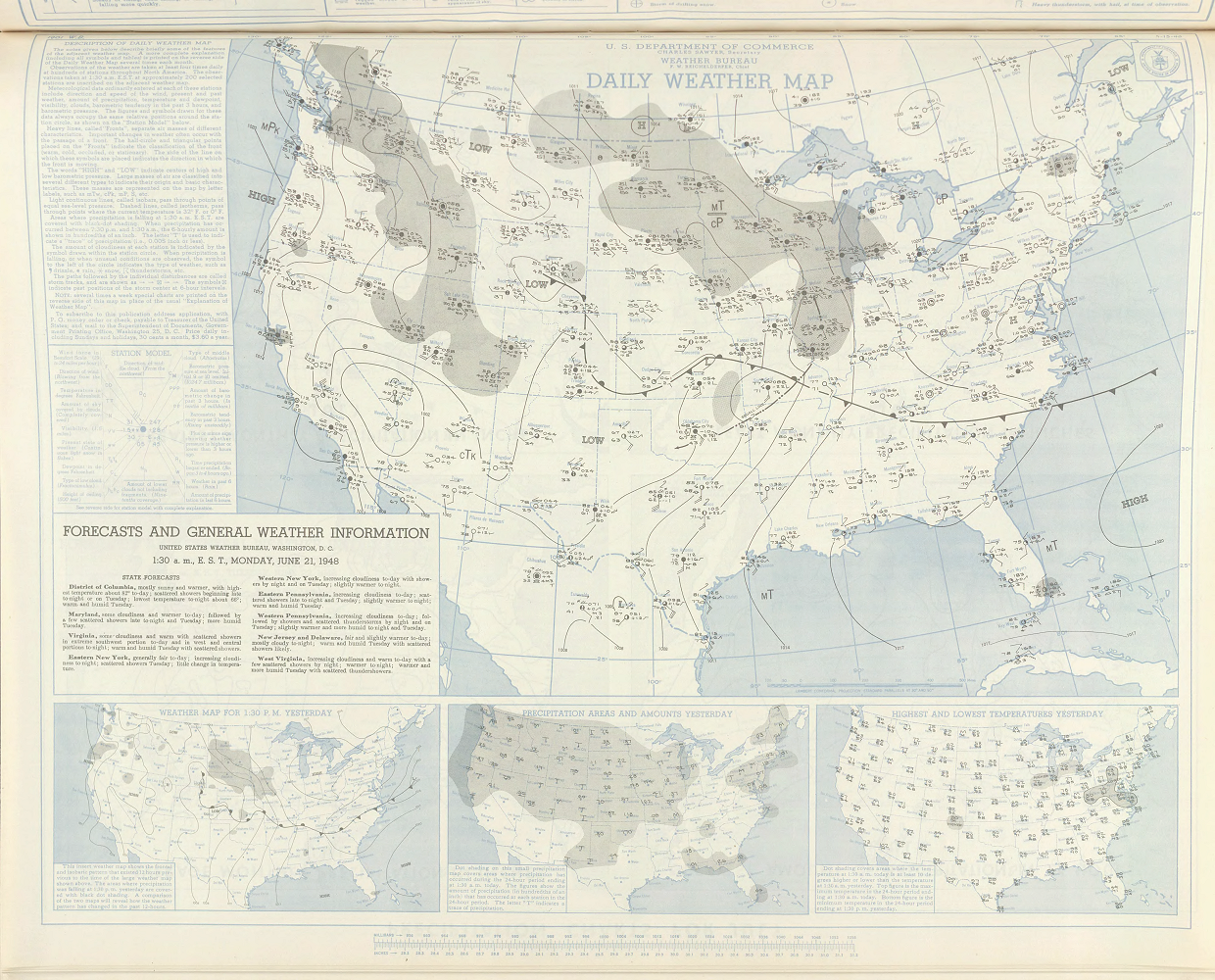 12:30 AM CST, June 21, 1948 |
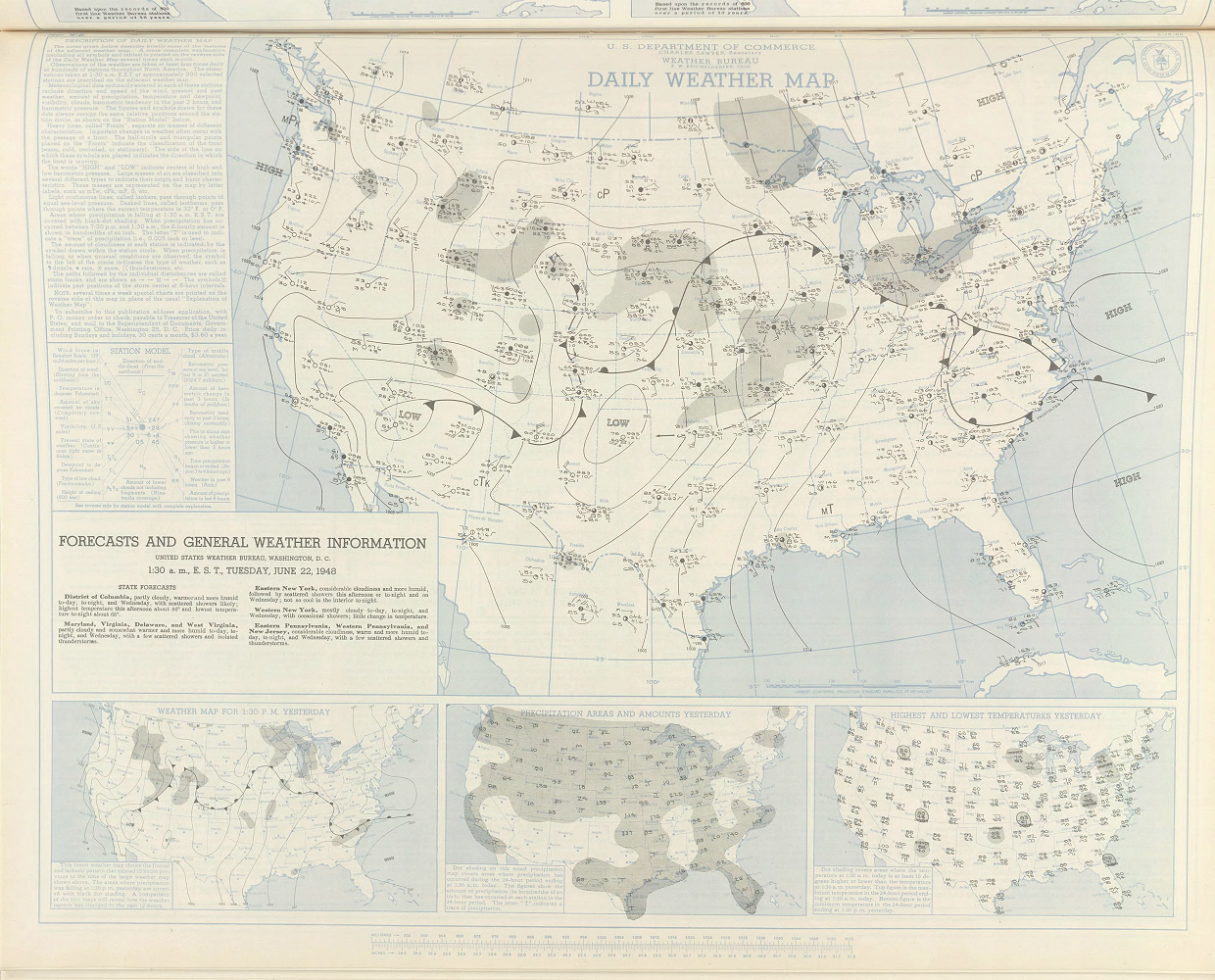 12:30 AM CST, June 22, 1948 |
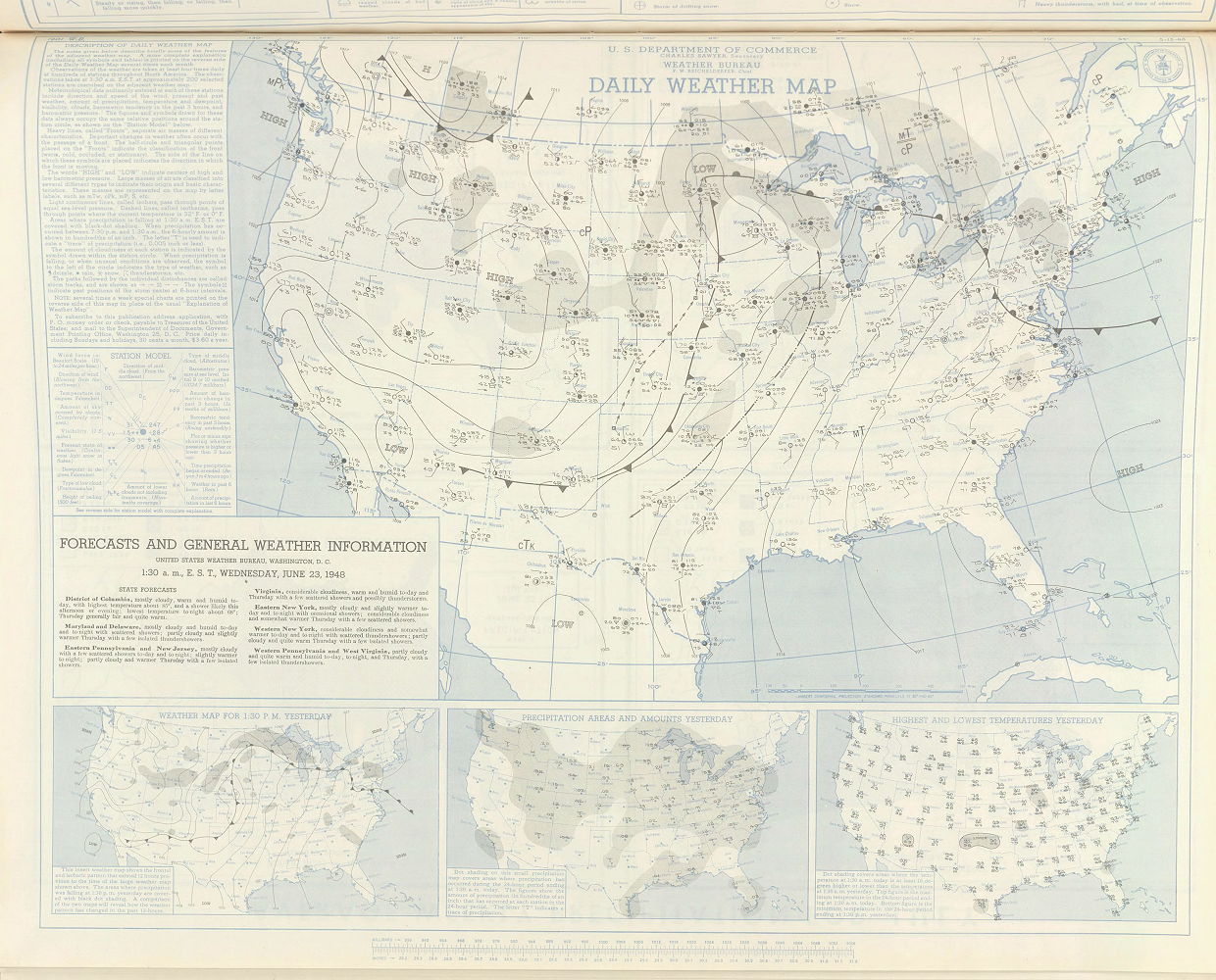 12:30 AM CST, June 23, 1948 |
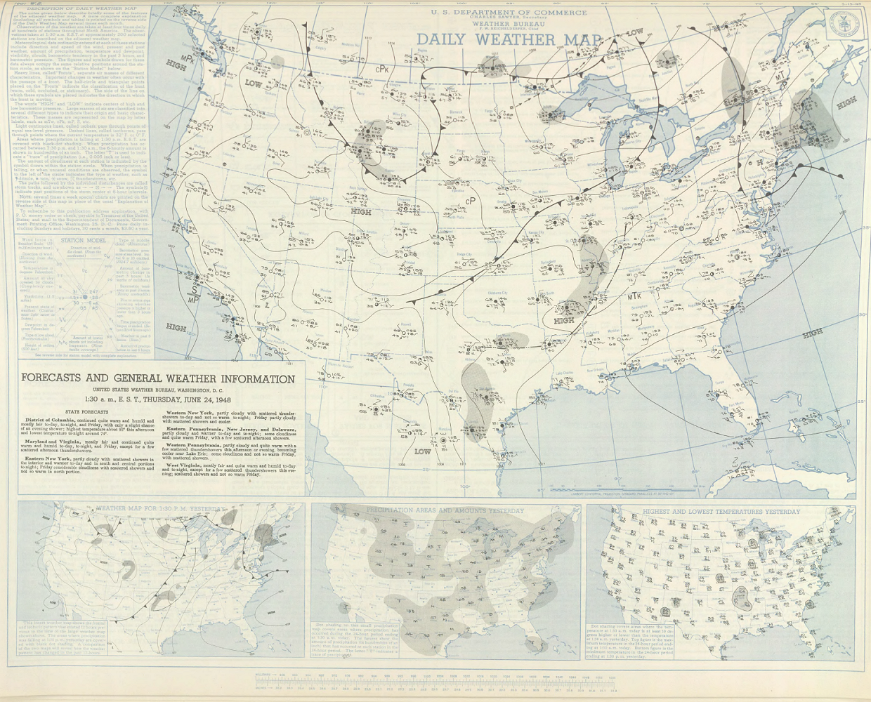 12:30 AM CST, June 24, 1948 |
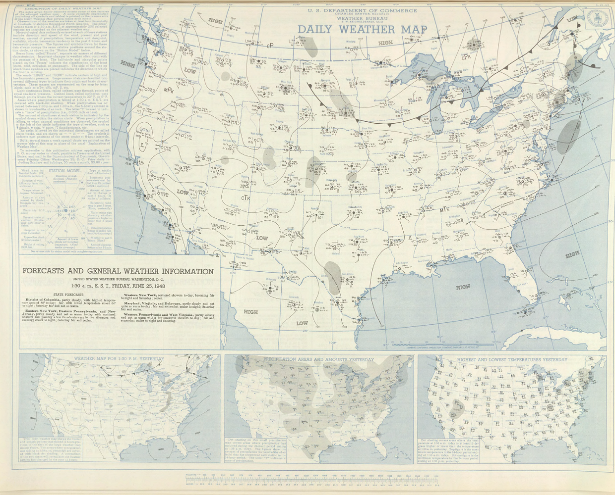 12:30 AM CST, June 25, 1948 |
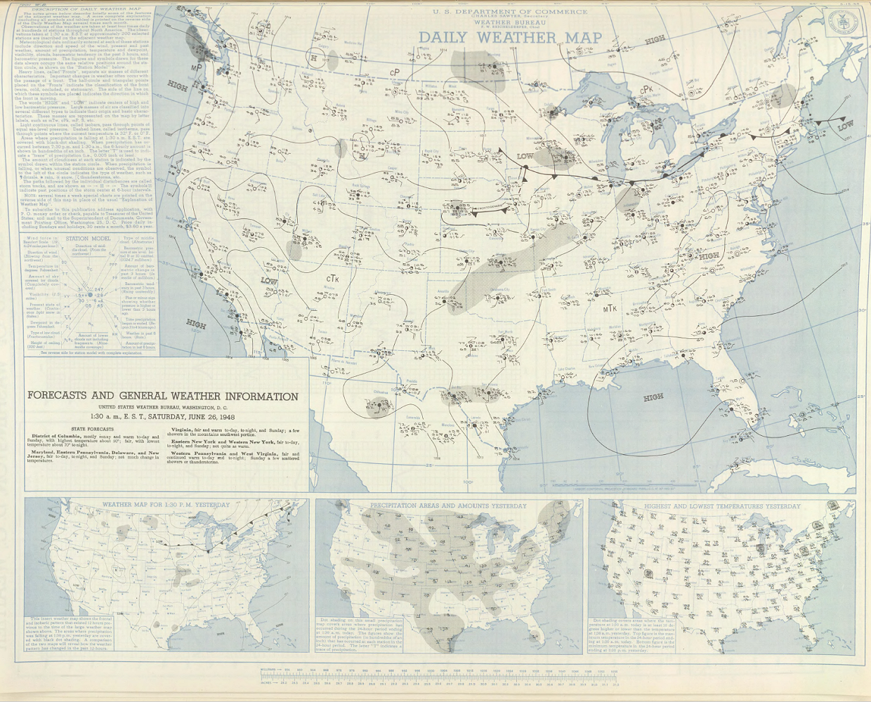 12:30 AM CST, June 26, 1948 |
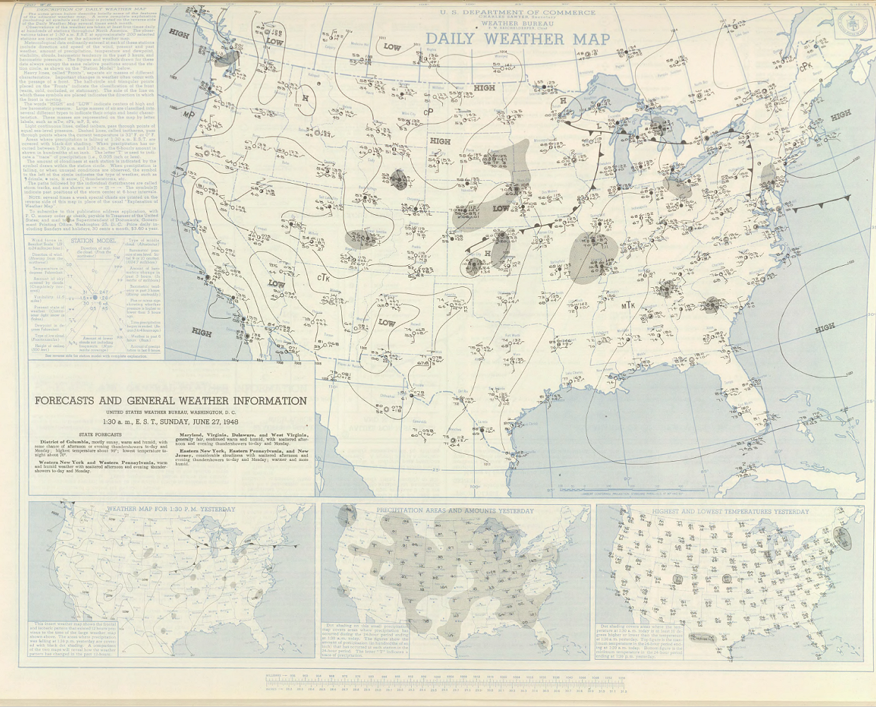 12:30 AM CST, June 27, 1948 |
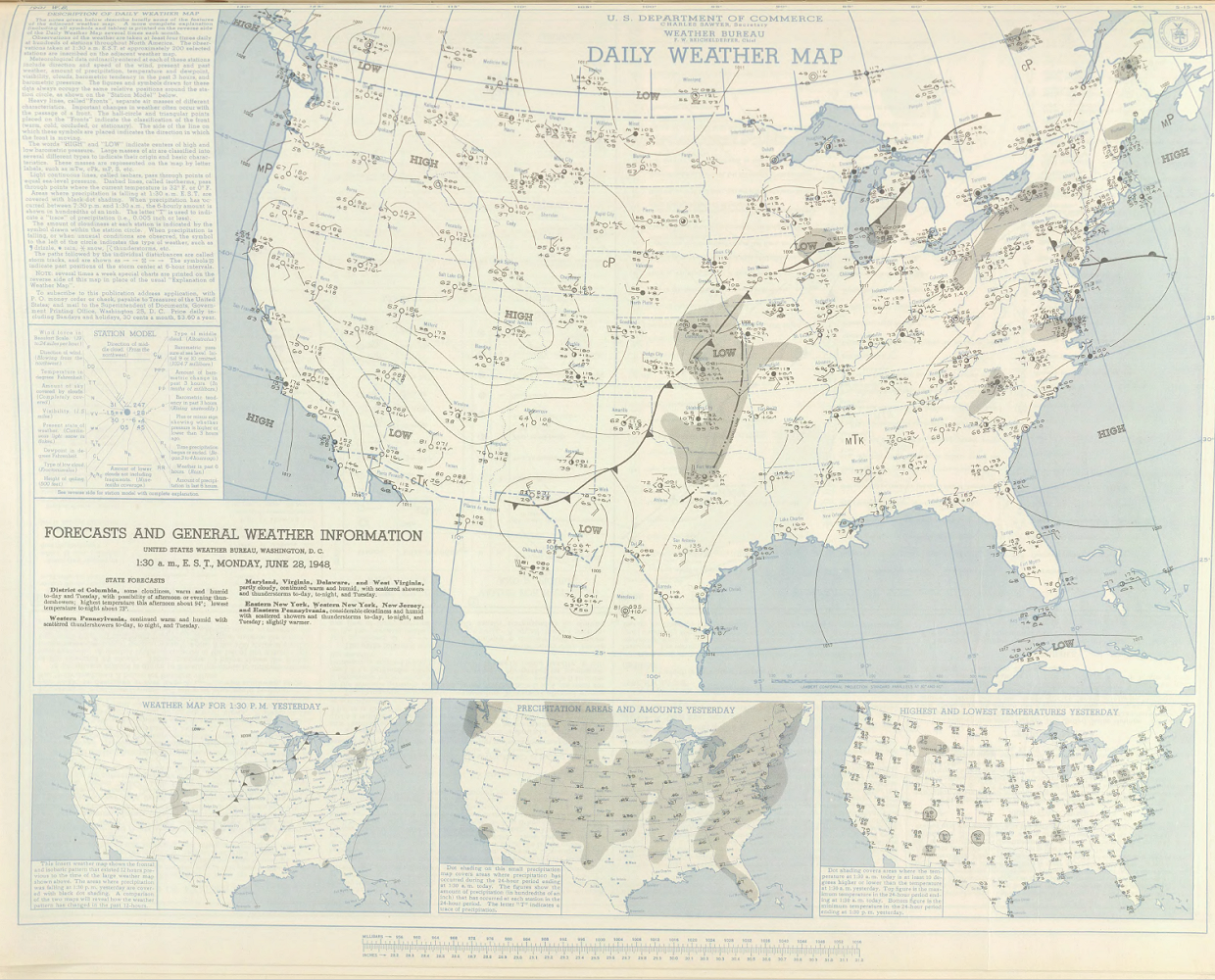 12:30 AM CST, June 28, 1948 |
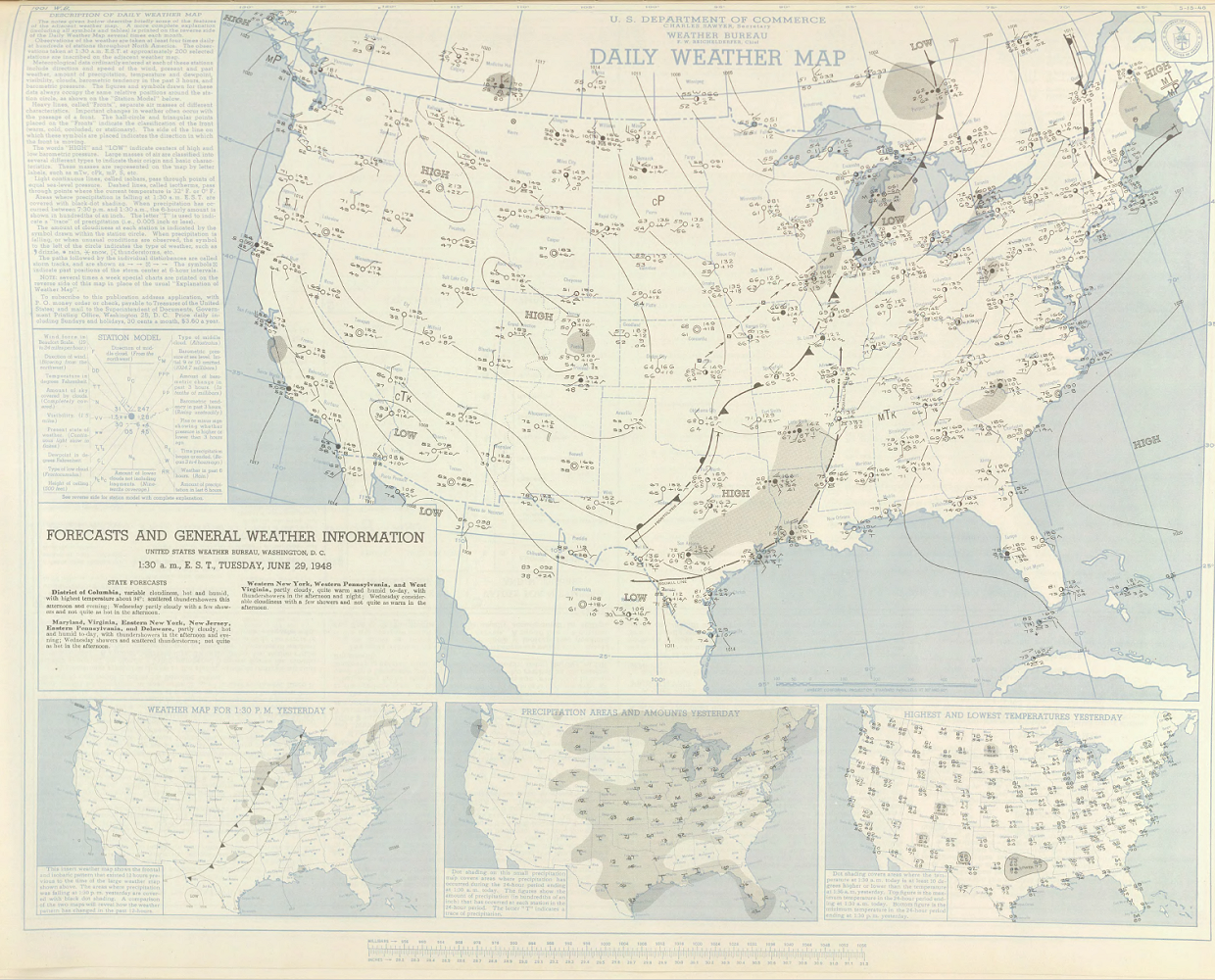 12:30 AM CST, June 29, 1948 |
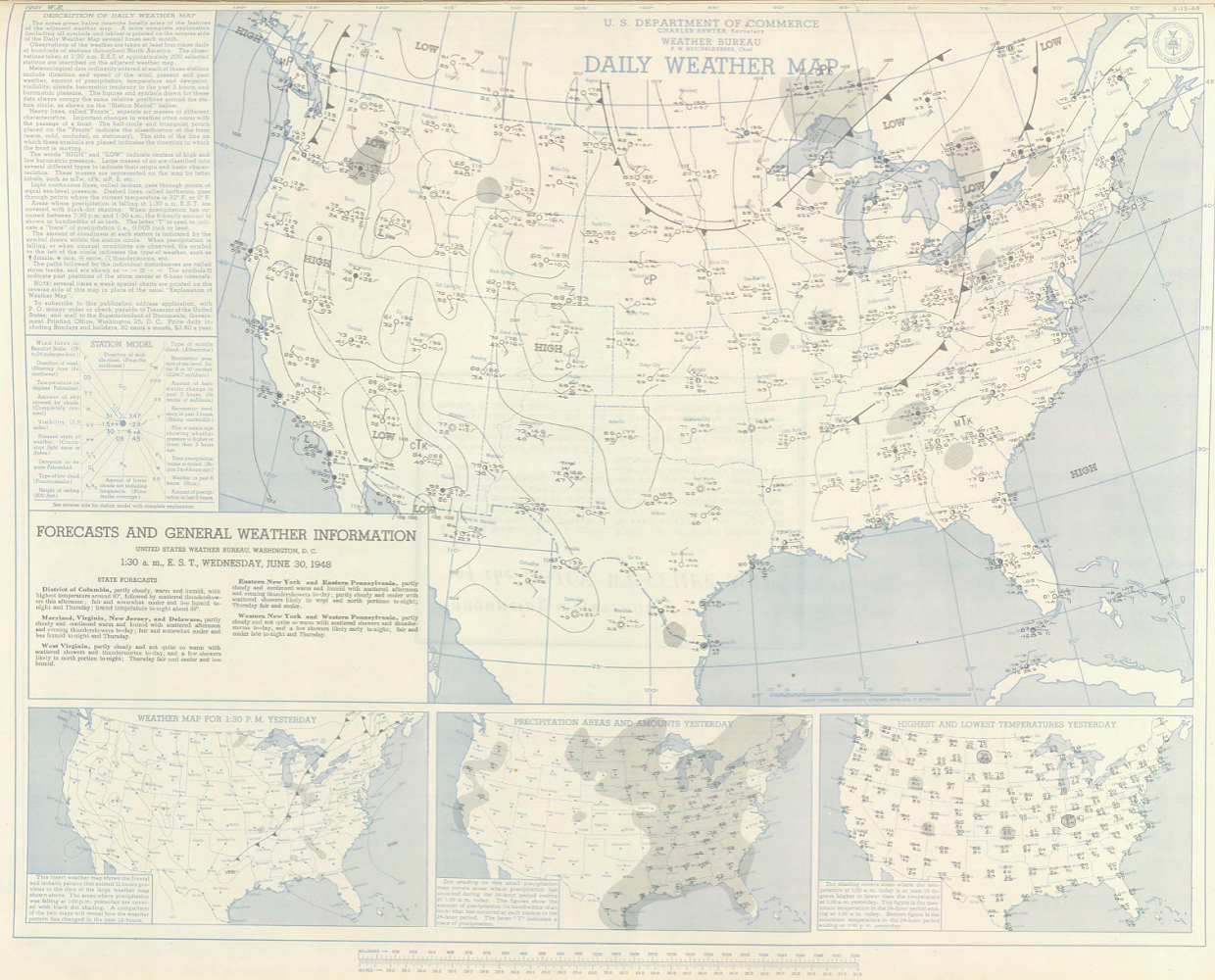 12:30 AM CST, June 30, 1948 |
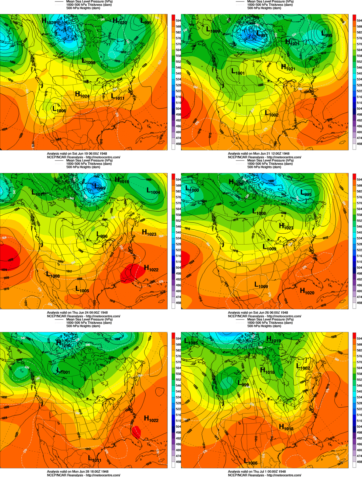
| June 19, 1948 | |
|---|---|
 12 AM CST, June 19, 1948 |
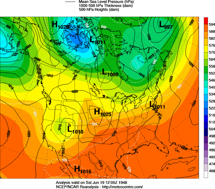 6 AM CST, June 19, 1948 |
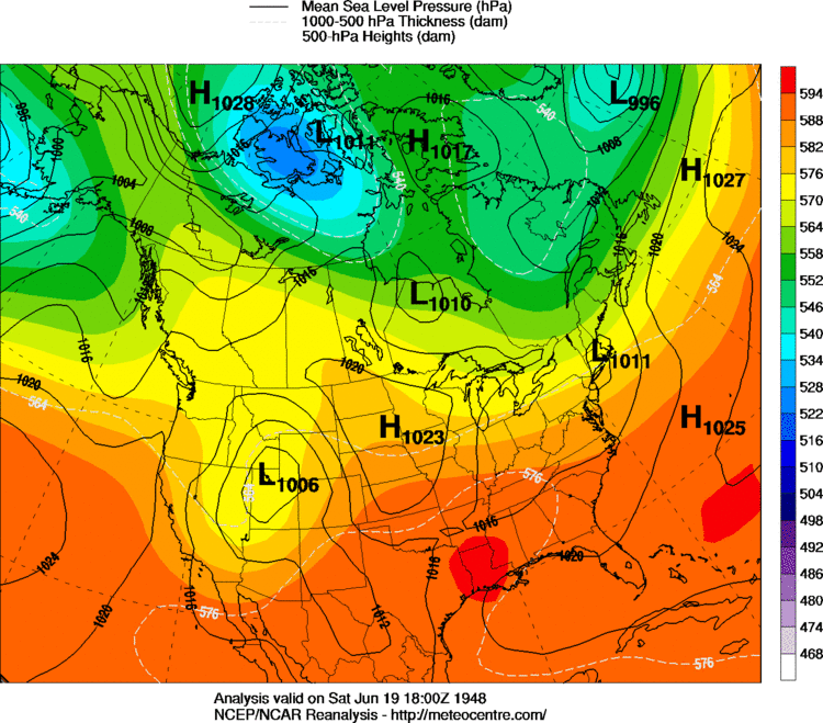 12 PM CST, June 19, 1948 |
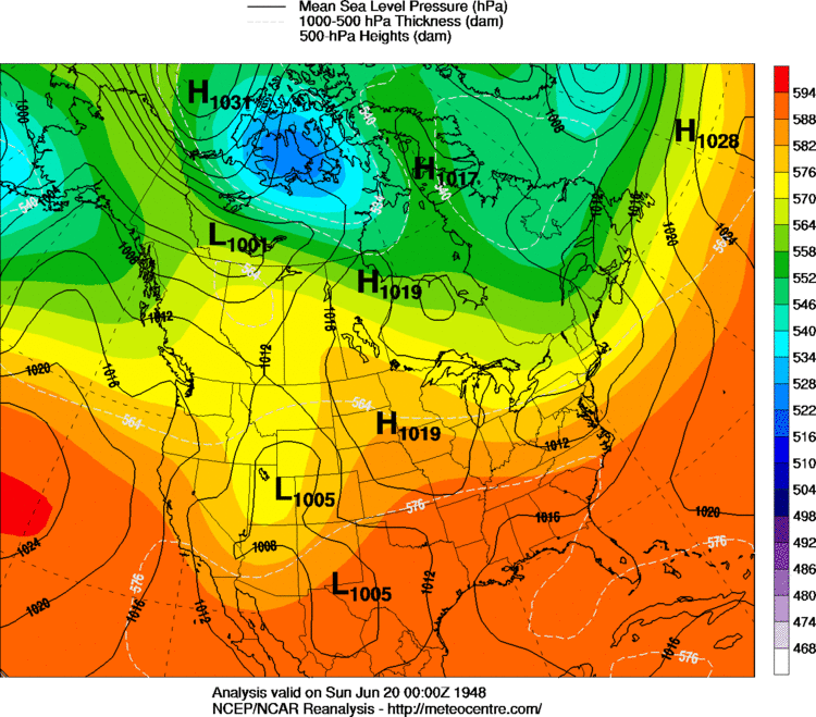 6 PM CST, June 19, 1948 |
| June 20, 1948 | |
|---|---|
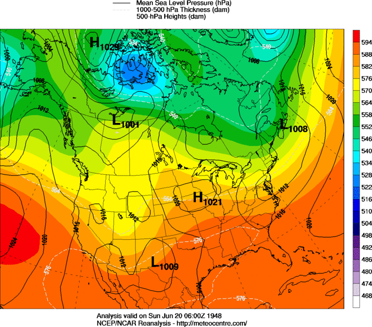 12 AM CST, June 20, 1948 |
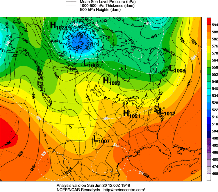 6 AM CST, June 20, 1948 |
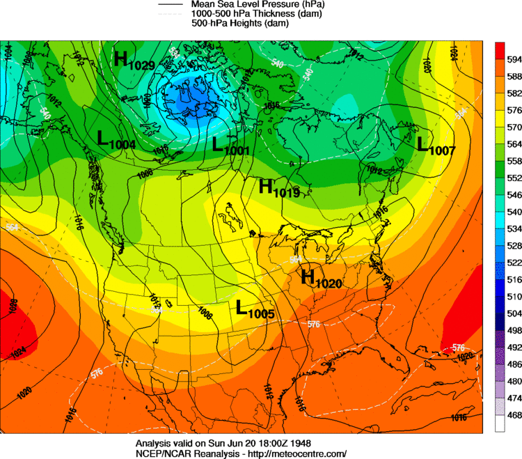 12 PM CST, June 20, 1948 |
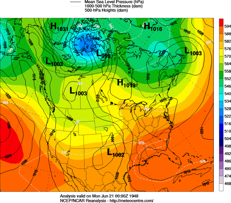 6 PM CST, June 20, 1948 |
| June 21, 1948 | |
|---|---|
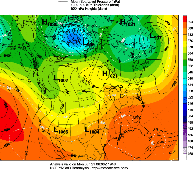 12 AM CST, June 21, 1948 |
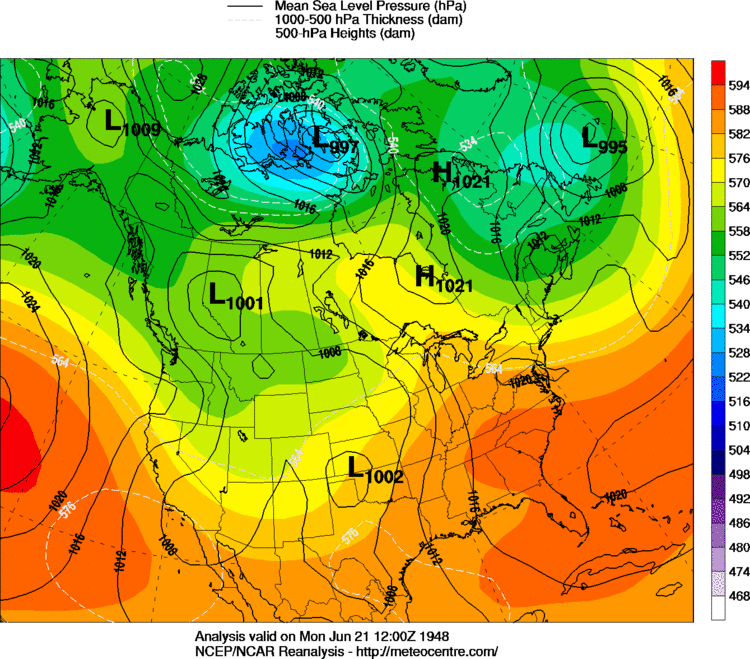 6 AM CST, June 21, 1948 |
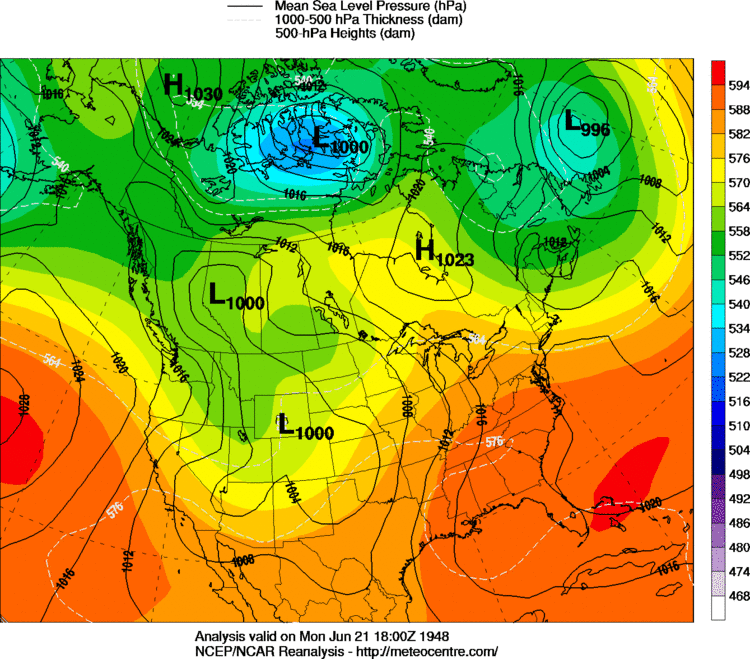 12 PM CST, June 21, 1948 |
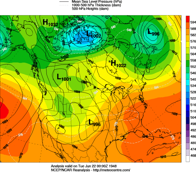 6 PM CST, June 21, 1948 |
| June 22, 1948 | |
|---|---|
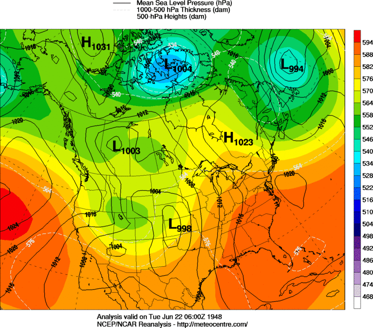 12 AM CST, June 22, 1948 |
 6 AM CST, June 22, 1948 |
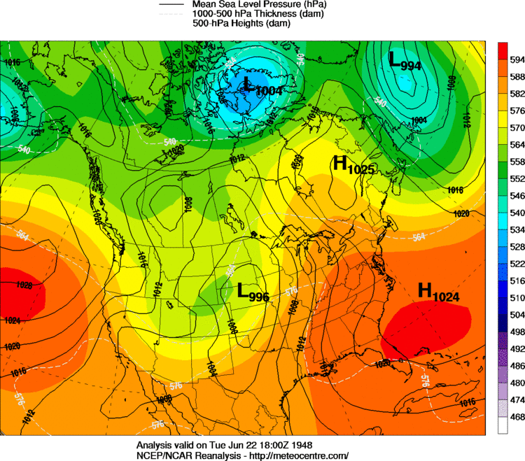 12 PM CST, June 22, 1948 |
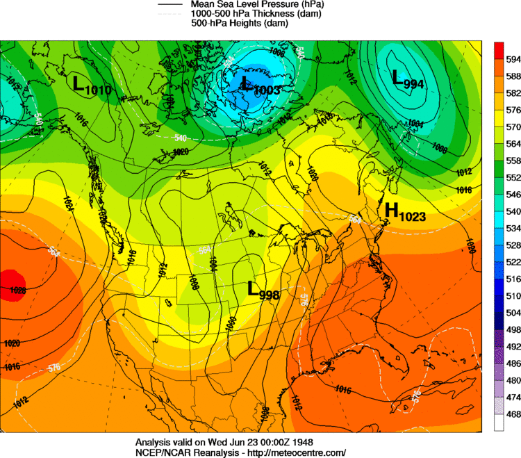 6 PM CST, June 22, 1948 |
| June 23, 1948 | |
|---|---|
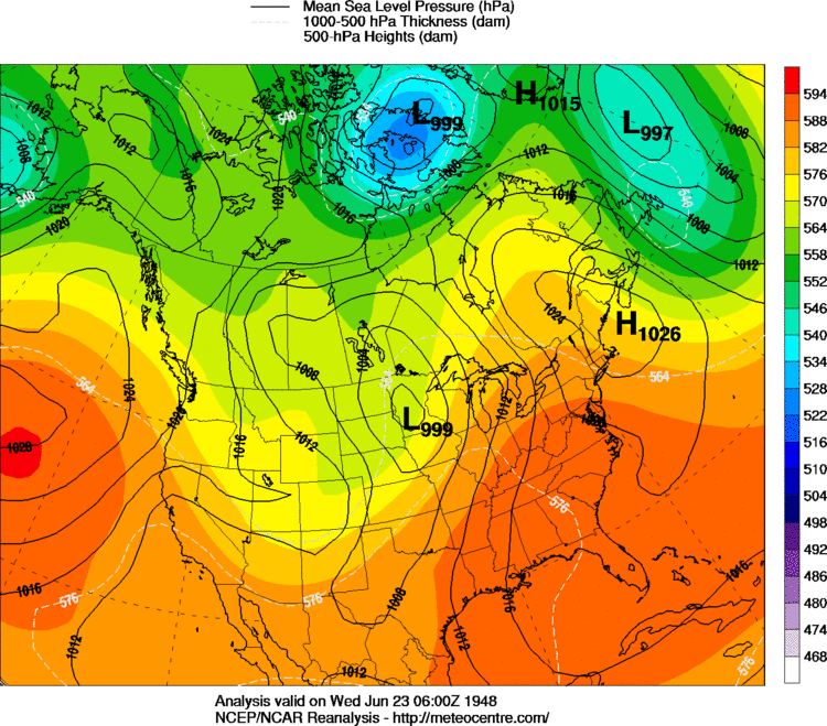 12 AM CST, June 23, 1948 |
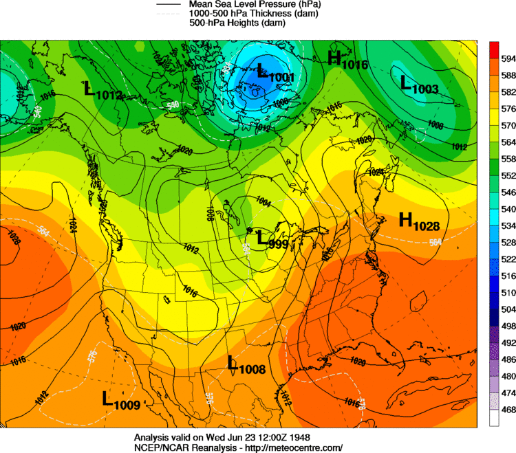 6 AM CST, June 23, 1948 |
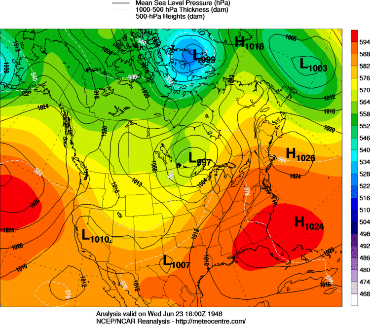 12 PM CST, June 23, 1948 |
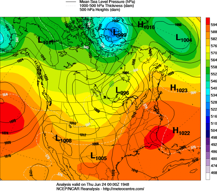 6 PM CST, June 23, 1948 |
| June 24, 1948 | |
|---|---|
 12 AM CST, June 24, 1948 |
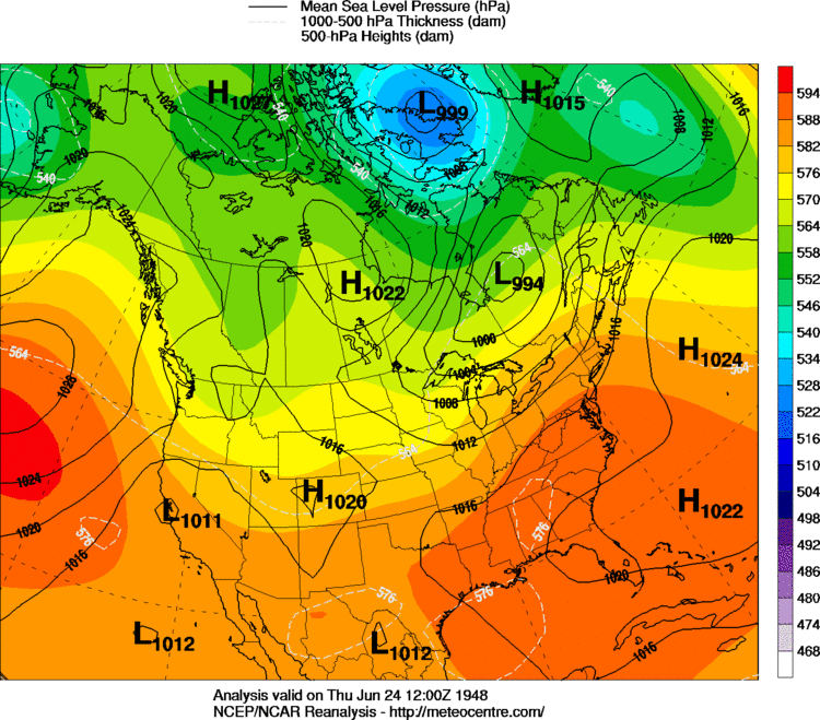 6 AM CST, June 24, 1948 |
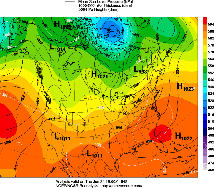 12 PM CST, June 24, 1948 |
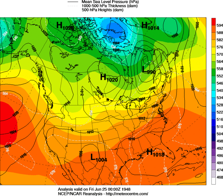 6 PM CST, June 24, 1948 |
| June 25, 1948 | |
|---|---|
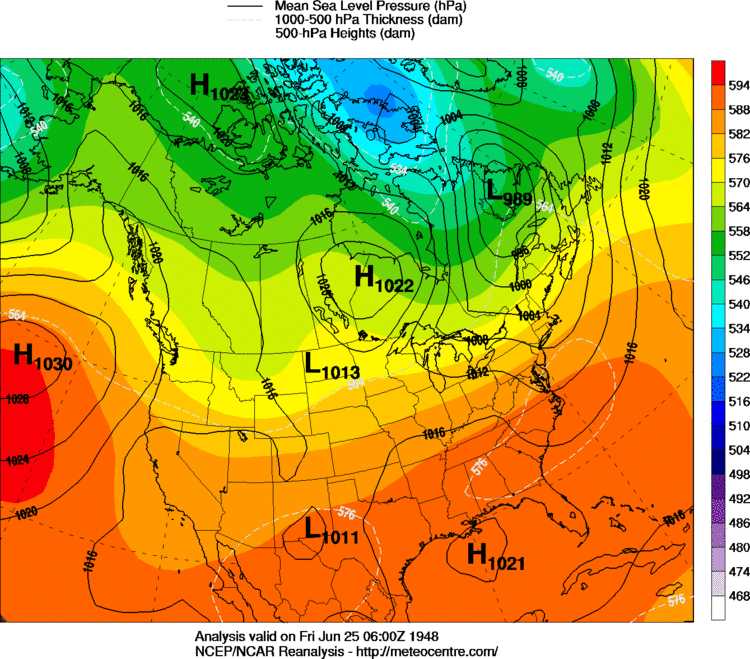 12 AM CST, June 25, 1948 |
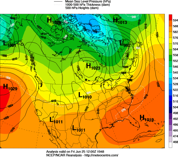 6 AM CST, June 25, 1948 |
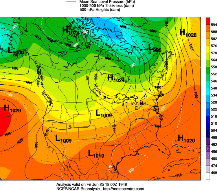 12 PM CST, June 25, 1948 |
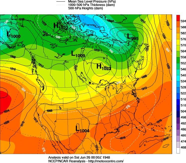 6 PM CST, June 25, 1948 |
| June 26, 1948 | |
|---|---|
 12 AM CST, June 26, 1948 |
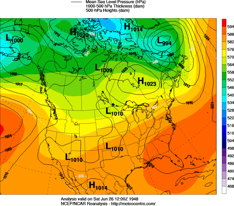 6 AM CST, June 26, 1948 |
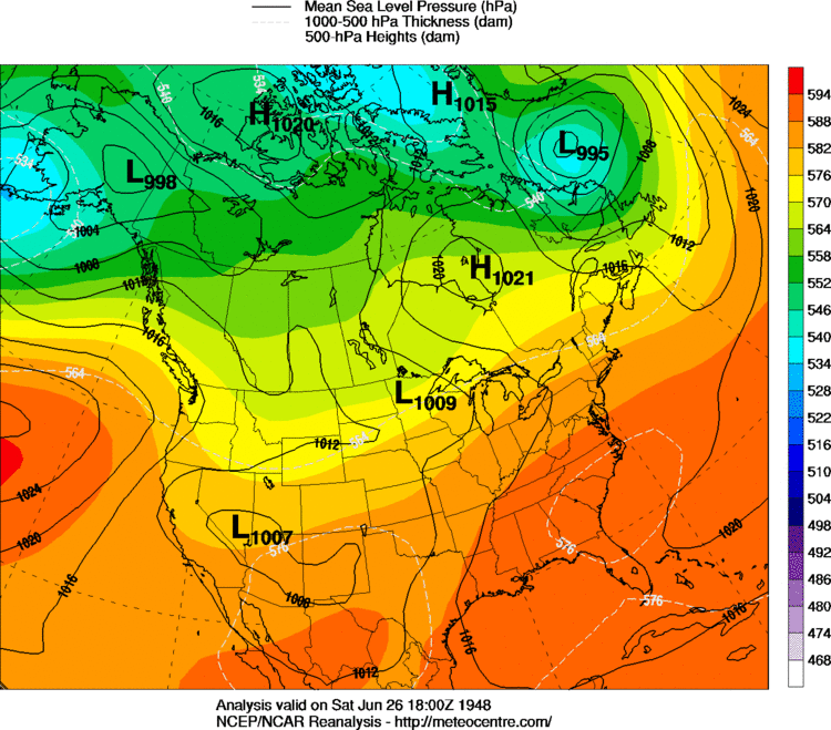 12 PM CST, June 26, 1948 |
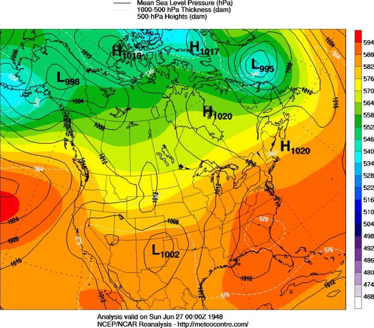 6 PM CST, June 26, 1948 |
| June 27, 1948 | |
|---|---|
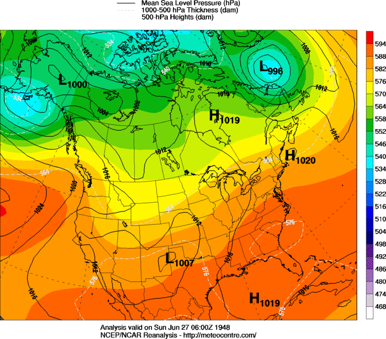 12 AM CST, June 27, 1948 |
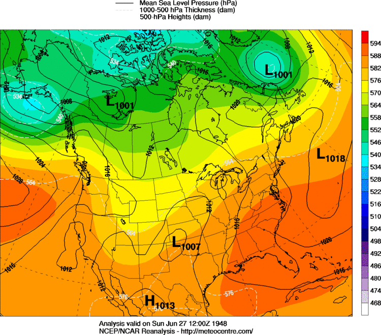 6 AM CST, June 27, 1948 |
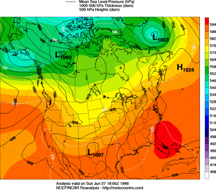 12 PM CST, June 27, 1948 |
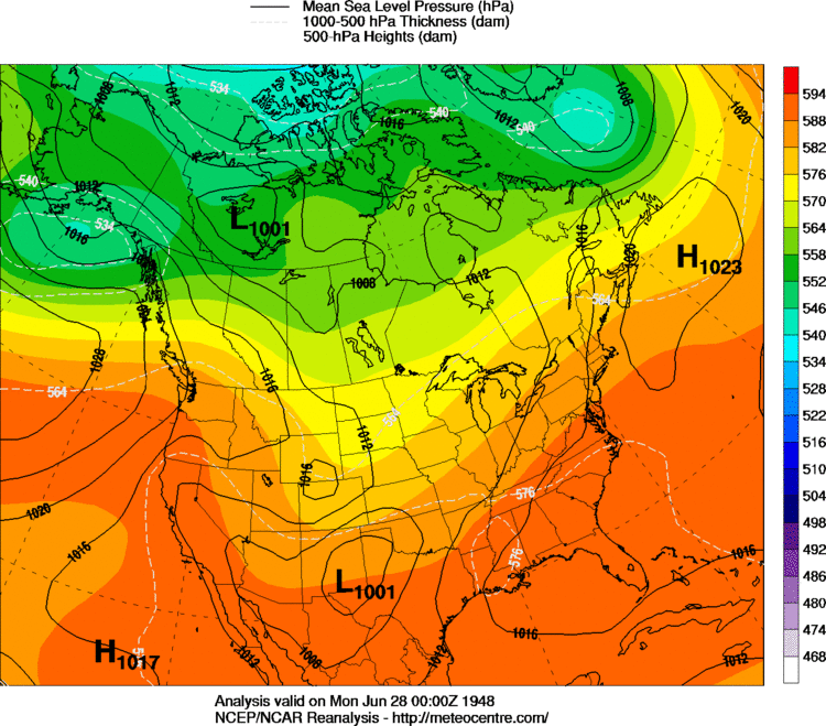 6 PM CST, June 27, 1948 |
| June 28, 1948 | |
|---|---|
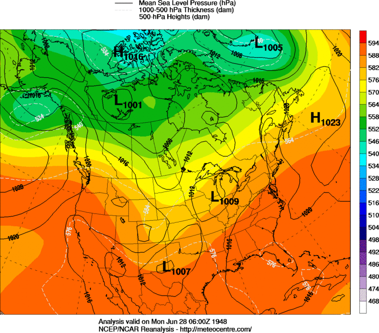 12 AM CST, June 28, 1948 |
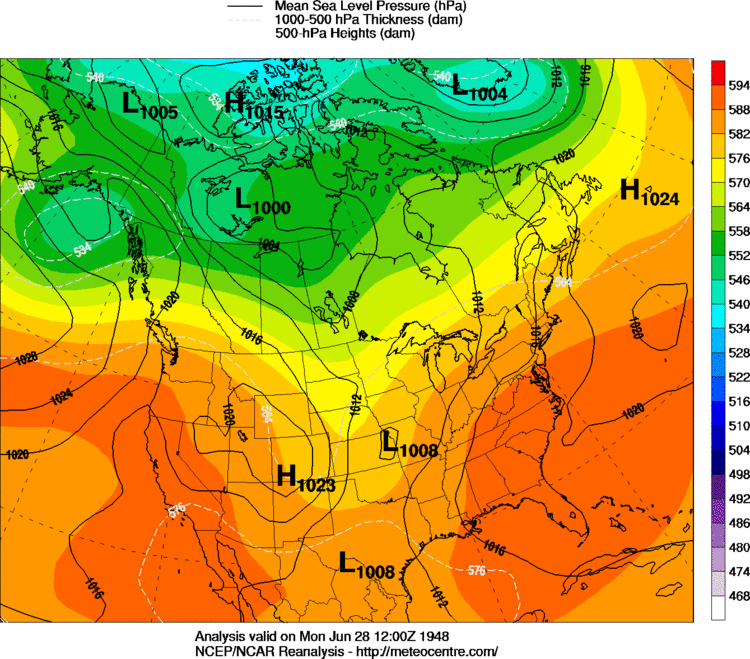 6 AM CST, June 28, 1948 |
 12 PM CST, June 28, 1948 |
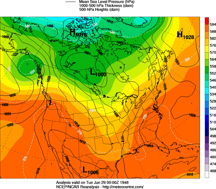 6 PM CST, June 28, 1948 |
| June 29, 1948 | |
|---|---|
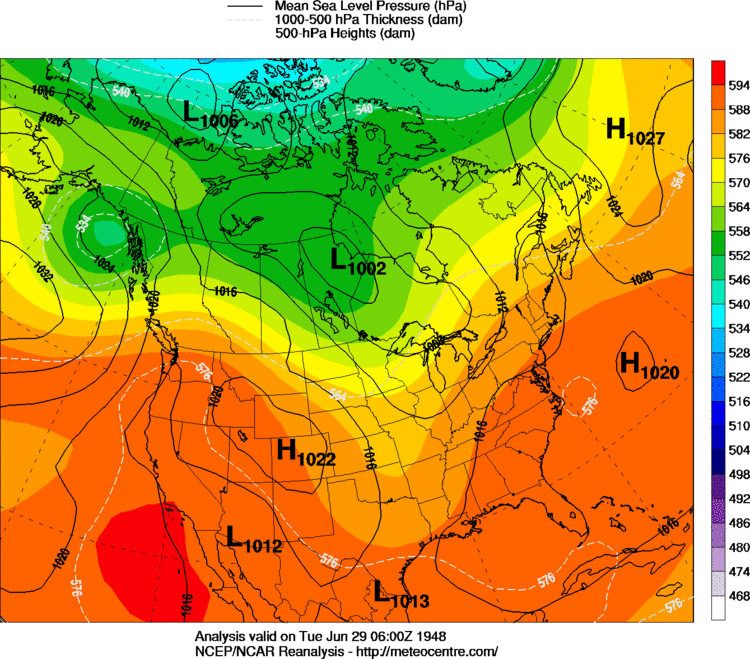 12 AM CST, June 29, 1948 |
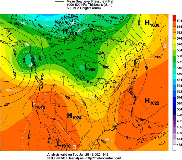 6 AM CST, June 29, 1948 |
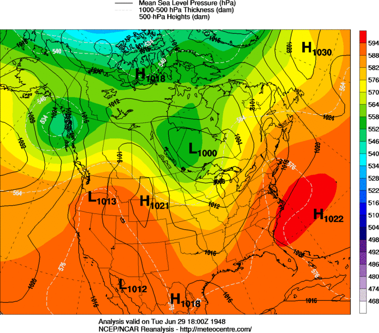 12 PM CST, June 29, 1948 |
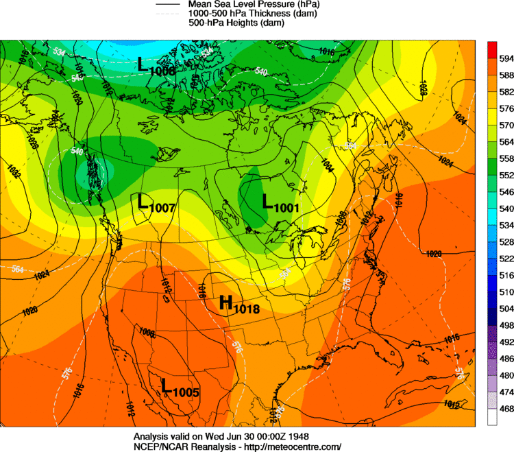 6 PM CST, June 29, 1948 |
| June 30, 1948 | |
|---|---|
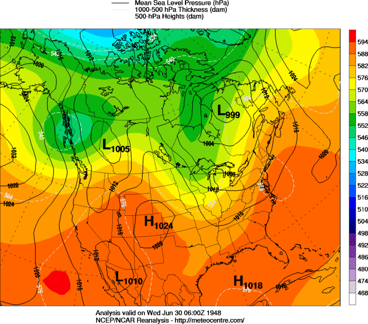 12 AM CST, June 30, 1948 |
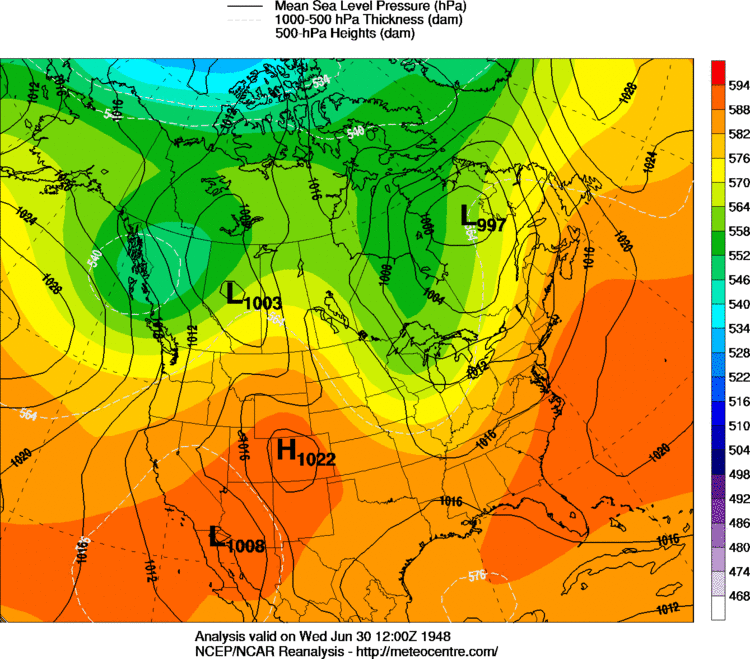 6 AM CST, June 30, 1948 |
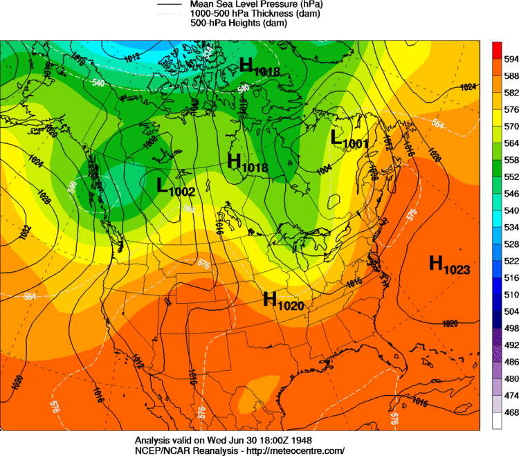 12 PM CST, June 30, 1948 |
 6 PM CST, June 30, 1948 |