Isolated severe storms capable of hail and gusty winds are possible mainly this evening across portions of the mid-Mississippi Valley. Clusters of thunderstorms may produce isolated flash flooding in the Florida peninsula. Elevated fire weather risk is possible in the Northern Plains into western Minnesota. Read More >
“If you don’t like the weather, wait fifteen minutes…”
The meaning of this often-quoted statement, credited to Will Rogers, is well known to most long-time Oklahomans who have experienced the sudden, dramatic weather changes that occur all too often in the southern Plains in the spring and fall. The transition months of March and November are particularly vulnerable to powerful cold fronts - the kind that can turn a bout of spring or summer-like warmth into a wind-driven ice box in a matter of hours, or even minutes.
A notable example of summer-to-winter cold fronts occurred on March 3, 1989. After an unseasonably warm high temperature of 74 in Oklahoma City, the cold air arrived late in the day and promptly plunged temperatures into the 30s in less than an hour. Severe thunderstorms with nickel-size hail struck parts of central Oklahoma that evening, after the arctic air had dropped surface temperatures to 20 degrees! Two days later, much of central and southeast Oklahoma were paralyzed by over a foot of snow and near blizzard conditions.
Another example was a strong cold front that occurred on November 10, 1995. The daily weather records for Oklahoma City tell the story. The high temperature of 83 degrees set the record high for the date, and the daily snowfall of half an inch set the snowfall record. The cold air arrived early that afternoon, dropping temperatures into the upper 20s and turning rain to snow by midnight.
As dramatic as these weather changes were, we must go back further in time to look at one such cold front (also known then as The Great Blue Norther) that established a set of weather records that arguably are unique in modern weather history. On November 11, 1911 (remembered easily for now as "11/11/11"), the afternoon temperature in Oklahoma City reached a record high for the date of 83, before plunging 66 degrees to a record low of 17 at midnight that evening. Both daily temperature records remain unbroken and untied since 1911.
Record high and low temperatures occurring on the same day are rare, but they do happen. The hard part, though, is not setting both records but keeping them without one or the other being broken or tied in later years. In this sense, the pair of daily records at Oklahoma City on 11/11/11 is unique because of the amazing length of time over which both the record high and low have survived.
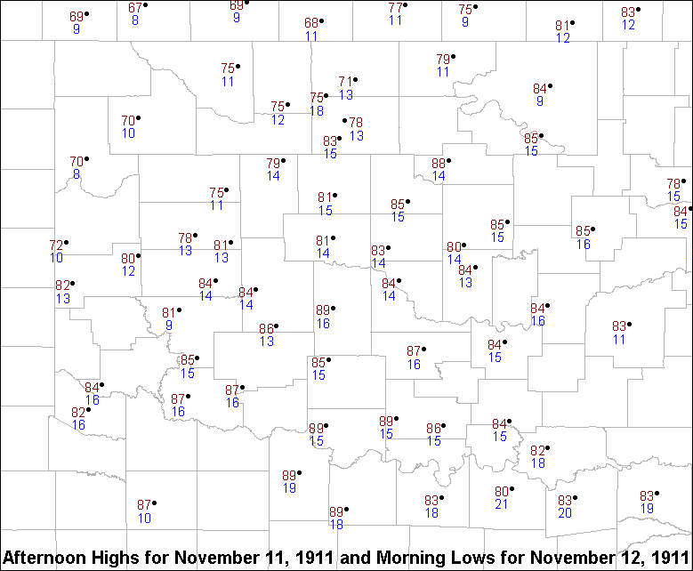
The accompanying map shows the observed high temperatures on November 11, 1911 and the observed lows the following morning, November 12th, across portions of Oklahoma, Texas, and Kansas. Temperature drops of 60 degrees were common, with some areas falling more than 70 degrees in roughly 12 hours.
The dramatic turn of weather events on 11/11/11 eventually affected most of the country. It began with a Canadian high pressure system that began to build over Alberta as early as November 9th. A low pressure system began to organize over the Rockies on the 10th and moved east into Iowa and Missouri on the 11th. Unseasonably warm air was drawn northward ahead of the low on the 11th, while in its wake, cold air plunged south across the entire central United States.
The unseasonably cold air eventually overspread the entire eastern United States as well, routinely dropping temperatures 30 to 70 degrees in a matter of hours. In Chicago, one man was overcome by heat and two others froze to death within a 24-hour period. Severe thunderstorms erupted from the mid-Mississippi valley into the Great Lakes, spawning destructive tornadoes in parts of Wisconsin, Iowa, Illinois, Indiana, and Michigan that killed at least a dozen people. Strong winds behind the cold front reached 30 to 50 mph in many areas, with gusts over 70 mph in some locations. The high winds tore a barge from its towing ship off the New England coast. Fourteen crew members were given up as lost
Except for the daily temperatures, there is little information on the accompanying weather changes in Oklahoma and north Texas that day. However, the following account from Springfield, Missouri, likely is representative of the sequence of events:
“By 2:30 pm...a dense greenish black bank of clouds was rising along the western horizon. By 3:30 pm dark and ominous appearing clouds extended along the northwestern horizon...and at 3:45 pm the winds shifted to northwest and immediately reached an extreme velocity of 74 mph. A temperature of 80 was recorded, breaking the record high temperature during any previous November in the last 25 years...and falling from 80 to 13 at midnight, which likewise breaks the record for low temperature this early in November. Rain, hail, sleet, and snow fell within a period of less than 2 hours, and a moderate electric storm commenced after the temperature had fallen to below freezing and more than an hour after the wind had shifted."
“The record for varieties of weather and violent fluctuations in meteorological elements during a 24-hour period has not heretofore been equaled at this station.”
Note: Many observing stations throughout the central United States still have either record highs or record lows that were recorded on 11/11/11. Springfield, Missouri is the only station other than Oklahoma City that has both records still on the books, but Springfield tied the record high of 80 in 1989.
