The following are some numbers related to Christmas Day weather in Oklahoma City, Oklahoma. The numbers are based on records going back to 1890.
|
Some of the more memorable weather events on Christmas Day in recent years include... 1955: The high of 54 was above average, but was a 32-degree drop-off from the previous day. A high of 86 on Christmas Eve was 38 degrees above the long-term average, and still stands as the all-time record high temperature for December. 1975: Rain changed to snow on Christmas Eve, with heavy snow falling that afternoon and continuing into early Christmas morning. Nearly 3 inches fell during the storm, but temperatures hovered just above freezing, and much of the snow melted when it reached the ground. 1983: Bitter cold with wind chills as low as 27 below occurred during the pre-dawn hours of Christmas Day. The high of 13 was an improvement over the previous day, as the high on Christmas Eve was 3 above zero. The low was zero, and wind chills dropped as low as minus 45 as north winds gusted to 38 mph. 1987: Freezing rain and sleet began before sunrise, and was the start of an infamous 2-day ice storm that left parts of Oklahoma without power for over a week. Sleet prevailed across the western and northern parts of Oklahoma City, while freezing rain devastated southern and eastern parts of the metro area. Despite heavy sleet and ice accumulations of up to 2 inches, total snowfall was only a trace. 1989: Christmas Day was a sunny, mild day with Temperatures in the 50s. But what made this Christmas memorable was the dramatic warm-up that was in progress. Three days earlier the temperature fell to minus 4, a new all-time record low for December. Winds of 20 mph at the time dropped wind chills to near 50 below. The next night, the December low temperature record was broken again when the temperature fell to minus 8. Two days later on Christmas Day, the temperature reached 57, giving Oklahoma City a 65-degree warm-up in two days. 2000: A major winter storm affected much of Oklahoma on December 25-26, with impacts similar to the storm in 1987. The storm began on Christmas Day across the region, with significant accumulations of snow and ice occurring Christmas night and into December 26. Heavy snow, accumulating 8 to 12 inches, fell across northwest Oklahoma. Meanwhile, a combination of snow, sleet, and freezing rain fell across west-central, central and north-central Oklahoma, with accumulations ranging from 2 to as much as 8 inches. One of the worst ice storms to ever affect the state of Oklahoma occurred in south-central and southeast Oklahoma, where ice and sleet accumulations from 1 to 2 inches were common. Statewide, around 170,000 residents were without electricity right after the storm, and power was not restored in some locations until almost 2 weeks later. 2009: Although no snow technically fell on Christmas Day, the record-setting blizzard that affected a large part of Oklahoma on Christmas Eve was fresh on everyone's mind. Snow accumulated between 5 and 7 inches from southwest into central Oklahoma, with several locations reporting over 10 inches! The snowstorm was made worse by the near continuous winds that were sustained near 40 mph with gusts as high as 60 mph. All major highways were shut down by early afternoon, stranding thousands of holiday travelers and last-minute Christmas shoppers. The snow finally moved east during the early evening hours, leaving behind snow drifts as high as five feet, and streets littered with abandoned cars.
|
|
||||||||||||||||||||||||||||||||||||||||||||||||||||||||||||||||||||||||||||||||||||||||||||||||||||||||||||||||||||||||||||||||||||||||||||||||||||||||||||||||||
The following are some numbers related to Christmas Day weather in Wichita Falls, TX. The numbers are based on records going back to 1923.
|
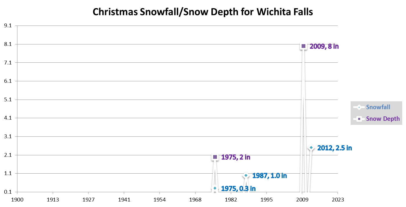
Some of the more memorable Christmas Days in recent years include... 1955: The high of 57 was above average by about 5 or 6 degrees, but it was a 30-degree drop-off from the previous day. A high of 87 on Christmas Eve was around 35 degrees above the long-term average, and is tied for the 2nd warmest daily temperature for December. 1983: Bitter cold with wind chills well below zero occurred during the pre-dawn hours of Christmas Day. The high of 14 was an improvement over the previous day, as the high on Christmas Eve was 11 degrees. 1989: Christmas Day was a sunny, mild day with Temperatures well into the 60s. But what made this Christmas memorable was the dramatic warm-up that was in progress. Three days earlier the temperature fell to minus 4, breaking the previous all-time record low for December by two degrees. The next night, the December low temperature record was broken again when the temperature fell to minus 7. Two days later on Christmas Day, the temperature reached 65, giving Wichita Falls a a 72-degree warm-up in just two days. 2009: Although no snow technically fell on Christmas Day, the record-setting blizzard that affected parts of north Texas on Christmas Eve was fresh on everyone's mind. Snow accumulated between 5 and 7 inches over a large area, with locations in Wichita and Clay counties reporting 7-10 inches! The snowstorm was made worse by the near continuous winds that were sustained near 40 mph with gusts as high as 60 mph. Most roadways were shut down by early afternoon, stranding thousands of holiday travelers and last-minute Christmas shoppers. The snow finally moved east during the early evening hours, leaving behind snow drifts as high as five feet, and streets littered with abandoned cars.  |
|
||||||||||||||||||||||||||||||||||||||||||||||||||||||||||||||||||||||||||||||||||||||||||||||||||||||||||||||||||||||||||||||||