Heavy snowfall events are rare in Oklahoma relative to other parts of the United States, but they occur with sufficient frequency to create a significant forecasting challenge. The purpose of this study is to quantify the frequency of heavy snow events in Oklahoma, in terms of monthly and seasonal trends as well as geographic distribution within the state.
Monthly climatological data summaries, compiled by the National Climatic Data Center, include daily 24-h snowfall totals from available first-order and cooperative observer stations in Oklahoma. Summaries typically include daily reports from 100 or more stations. The actual number varies from month to month, due to missing or incomplete data, relocation of observing sites, and/or changes in active status of some sites over the years.
Heavy snow events, for purposes of this study, are defined as those which produce at least one observed 24-h total of six inches or more in the state, or at least two observed 24-h totals of four inches or more. Once either of these criteria were met, snowfall totals were examined for every available observing site from that date and the dates immediately preceding and following it. Storm totals were determined at each site by adding all measurable snowfall totals on consecutive days including and surrounding the date identified. Each event was identified using the first and last calendar dates in which measurable snowfall was reported, e.g., 5-7 January 1988. (Note that some events did not occur entirely within a single calendar month, e.g., 31-December 2000-1 January 2001. Such events were assigned to either a] the month with the most calendar days affected, or b] the month in which they began. So the above example was a December event, while one occurring over, say, 31 January - 2 February would be a February event. Surprisingly, there were very few such "end-of month" events.)
Geographic distribution of snowfall for each event was determined by identifying the counties which were wholly or largely affected by storm totals of four inches or more and eight inches or more. A certain amount of subjectivity was necessary, due to variations in the number and distribution of available reports. For each event, there were enough data points to develop a reasonably accurate subjective analysis of geographic snowfall distribution for that event. But there were very few data points for which data were available consistently throughout the entire 50-year period of study. Many sites either closed, opened, relocated, or had missing reports at some point during the period. As such, it was not possible to develop long-term objective numbers of events for each specific observing site.
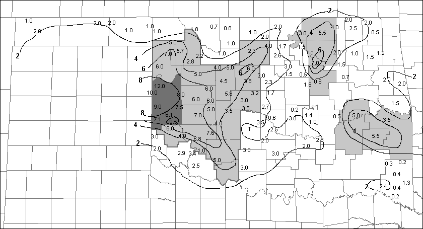
All available storm totals were plotted and subjectively analyzed for each event, providing a map of the geographic distribution of snowfall for that event. Counties affected by the event were then identified based on the analysis. An example is shown in Fig. 1. Note that in many cases there were counties which did not contain any data points, so it became necessary to evaluate the analyses to determine whether those data-void counties were affected by the event. (The process of determining counties affected is qualitatively similar to determining which counties are to be included in a severe thunderstorm or tornado watch. The process arguably is subjective in many cases, but should yield meaningful data given a sample size of over 200 events.) Seasonal and monthly frequencies of events for each county were then determined by simply adding up the total number of events affecting the given county.
A total of 225 heavy snow events were identified between January 1951 and April 2001, a period of just over 51 years. This results in an average of between four and five events per season. There have been only two winter seasons without a heavy snow event in Oklahoma: 1962-63 and 1973-74. In other words, heavy snow has fallen somewhere in Oklahoma in roughly 95 percent of all winter seasons. Of the 225 events which produced storm totals of four inches or more, 189 produced these amounts somewhere in the main body of Oklahoma; heavy snowfall in the remaining 36 events was confined to the three counties of the Oklahoma panhandle.
Heavy snow events have occurred as early as October and as late as May. The earliest event occurred on 8-9 October 1970, while the latest occurred on 3 May 1978. (Both were limited to the far western panhandle.) The overall frequency of events increases gradually to a peak in January, then remains relatively constant through February and March, before dropping much more abruptly in April (Fig. 2).
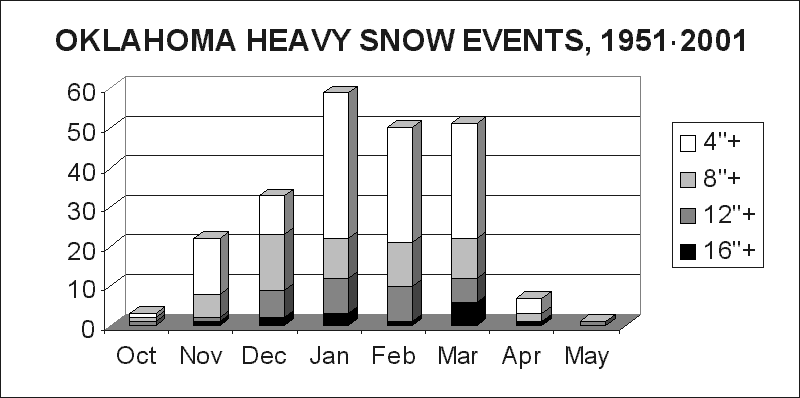
Of the 225 events, 102 produced maximum totals of 8 inches or more (two per year), 48 produced a foot or more somewhere (nearly one per year), and 14 produced a maximum storm total of 16 inches or more (about once every three years). The monthly distribution of eight- and 12-inch events (Fig. 2) shows a relatively constant frequency throughout the peak months of December through March. But the distribution of 16-inch events shows an interesting late-season peak, with a maximum in March. This apparent preponderance of "mega" snowstorms late in the winter season is further demonstrated in the list of ten heaviest snowstorms in Table 1 (as ranked by maximum storm total): Five of the ten heaviest events occurred in March.
Table 1. Heaviest snowfall events in Oklahoma, 1951-2001. Rankings are based on maximum storm totals (Max, inches). Location of the maximum reported storm total for each event is given.
|
The numbers in Fig. 3 were obtained for each county by tallying the number of times the given county was "hit" by heavy snowfall during the period. They thus represent the number of heavy snow events which produced four-inch or greater storm totals over at least a part of the county. With the period of study being just over 51 years, one can divide the numbers shown by 51 to obtain an approximate annual (or seasonal) frequency of four-inch or greater events. These frequencies are depicted by contours representing "turnaround times," i.e., the average time between four-inch snowfall events in the given area.
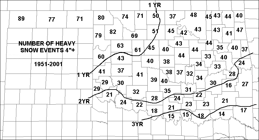
(Note: It is reasonable to expect that larger counties would have more events than smaller ones, simply by virtue of the fact that they are larger "targets." However, the data do not show a distinct size bias in most cases, probably because the counties of Oklahoma are, for the most part, similar in size. One exception was made for Osage county in northeast Oklahoma, which is noticeably larger than surrounding counties. In order to minimize any potential size bias, Osage county was split into north and south sections for this study. The dividing line is an eastward extension of the border between Kay and Noble counties, the two counties immediately west of Osage county.)
Figure 3 shows a marked preference for heavy snow in northwest Oklahoma. Much of the northwest one-fourth of the state experiences heavy snow more than once per year, on average. In the western and central panhandle, the average is closer to two per year. These frequencies are more than five times greater than those along the Red River counties in far south central and southeast Oklahoma, where heavy snow falls on average only about once every three to four years. For much of the rest of Oklahoma, including the larger population centers around Lawton, Oklahoma City, and Tulsa, heavy snow events occur, on average, once every one to two years.
Figure 4, obtained in the same manner as Fig. 3, shows the frequency of eight-inch or greater snowfall events. Geographic distribution generally is similar, with greatest frequencies in the panhandle and northwest. Snow events of eight inches or more occur on average more than once every other year in the panhandle. Lowest frequencies extend along the entire Red River region, where the data suggest eight-inch snowfall events occur on average only once every 20 years or so. Most of the counties in west central, central, and northeast Oklahoma average around 5 to 10 years between eight-inch snowfall events.
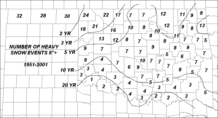 Figure 4. Number of 8-inch or greater snow events by county, 1951-2001. Contours are frequencies, given as average turnaround times for a single event.
In order to look at geographic variations by month, the numbers in Figs. 3 and 4 were broken down by month. (Actually, the monthly totals were derived first; Figs. 3 and 4 were obtained later by adding up the respective monthly totals.) The monthly results constituted another eight pairs of figures similar to Figs. 3-4. In the interest of condensing the presentation of all these data into a more manageable form, it was decided to divide the state into a number of regions, and calculate monthly numbers for each region by averaging the monthly totals from each of the counties in that region. These numbers then could be plotted in the form of bar graphs for each region, and displayed on a single figure which would show frequency variations by month and by region. The result is shown in Fig. 5.
Subdivision of the state began with the nine standard geographic divisions used by the Oklahoma Climatological Survey (OCS) in their data publications. A further subdivision was performed by splitting eight of the divisions in half again (all but the southeast division). The final result is 17 subdivisions as shown in Fig. 5, with solid lines outlining the OCS regions and dashed lines indicating the subdivisions.
Looking at the distribution of four-inch or greater events (light gray bars on the graphs in Fig. 5), it is clear that January is the peak month across southern and east central Oklahoma. But the peak month shifts to February from west central to north central Oklahoma. In between, much of southwest, central, and northeast Oklahoma is equally split between January and February. In the panhandle and far northwest, the peak month is March. In fact, the highest frequencies for any month and any region are in the panhandle region in March. But there is evidence of a bi-modal distribution in the far northwest, which includes a secondary earlier peak in December or January.
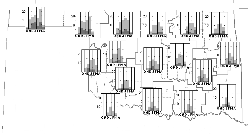
Evidence for a dual peak in frequencies in far northwest Oklahoma is more evident in the distribution of eight-inch events (darker bars in Fig. 5). A relative minimum in January or February is present in the three northwestern-most regions, and in fact extends eastward into northeastern Oklahoma. In general, frequency distributions for eight-inch events are consistent with those for four-inch events. But the data show that in northeastern Oklahoma, the peak time for eight-inch snow events shifts from January/February to March. These findings are consistent with the fact that a larger number of "big" snow events occur later in the season (section 3 and Table 1).
Oklahoma averages between four and five heavy snow events per season. They are most likely to occur in northwest Oklahoma, where most counties can expect one to two snowfalls of four inches or more per season. Far south-central and southeast Oklahoma are the least likely areas to receive heavy snow, but even these areas can expect a four-inch or greater snowfall about once every three to four years. On a seasonal basis, heavy snow can occur in the state as early as October or as late as early May (at least in the panhandle).
For the state as a whole, the frequency of heavy snow events increases gradually through fall and early winter to a peak in January, then levels off through February and March before dropping sharply in April. But the peak frequency varies by region - January in southern and east-central Oklahoma, to February in west central and north-central Oklahoma, to March in the panhandle. The most likely time and place for a heavy snow event in the state is in the panhandle in March. The panhandle area may experience a dual peak in heavy snow frequency, with the maximum in March preceded by a weaker maximum in December or January and a relative minimum in January or February.
The monthly frequency of "big" snow events, which produce eight inches or more, generally is similar to that of four-inch events - except in northeast Oklahoma, where the peak frequency shifts to March. Data on even larger "mega-snow" events, producing storm totals of 16 inches or more, suggest that March is the most likely month of occurrence in Oklahoma.