Atlanta/Peachtree City, GA
Weather Forecast Office
Supercell Thunderstorms Visit Georgia
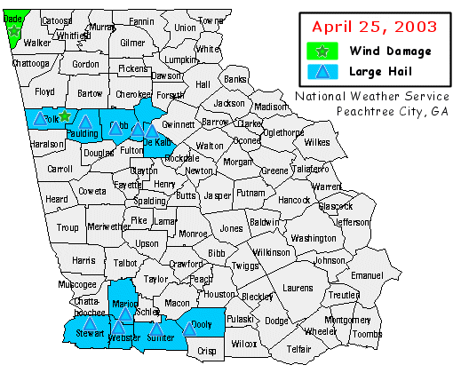
April 25, 2003 Supercell thunderstorms moved across parts of Georgia during the late afternoon and evening hours of Friday, April 25, 2003. ( See map below ) Although Doppler radar showed developing tornadoes within the storm clouds, none of the tornadoes developed to the point of reaching the ground. The violence associated with the storms was largely caused by large hail. Golfball-size hail was reported with a supercell that crossed out of Alabama into Polk County west of Cedartown, and then travelled east into the city of Atlanta. Golf-ball size hail also occurred later in the evening near Preston and Americus in west central Georgia. The storm in Polk County also produced a downburst that caused damage in the southern part of the county. Another downburst occurred in Dade County (in the northwest corner of the state) which resulted in damage to trees and buildings. A vehicle was struck by a falling tree and two occupants of the vehicle were injured. Damage or large hail was reported in at least 11 counties across North and Central Georgia.
|
Current Hazards
Outlooks
Georgia Road Conditions
Nationwide
Local Storm Reports
Local
Submit Storm Report
Forecasts
Forecast Discussion
Incident Support
Tropical Weather
Local
Computer Models
Graphical
Aviation Weather
Activity Planner
Recreational Forecast
Fire Weather
Current Weather
Rivers/Lakes
Satellite Images
Observations
Maps
Radar Imagery
Regional Loop
Nationwide
Warner Robins
Peachtree City
US Dept of Commerce
National Oceanic and Atmospheric Administration
National Weather Service
Atlanta/Peachtree City, GA
4 Falcon Drive
Peachtree City, GA 30269
770.486.1133
Comments? Questions? Please Contact Us.


