Atlanta/Peachtree City, GA
Weather Forecast Office
February 12, 2010 |
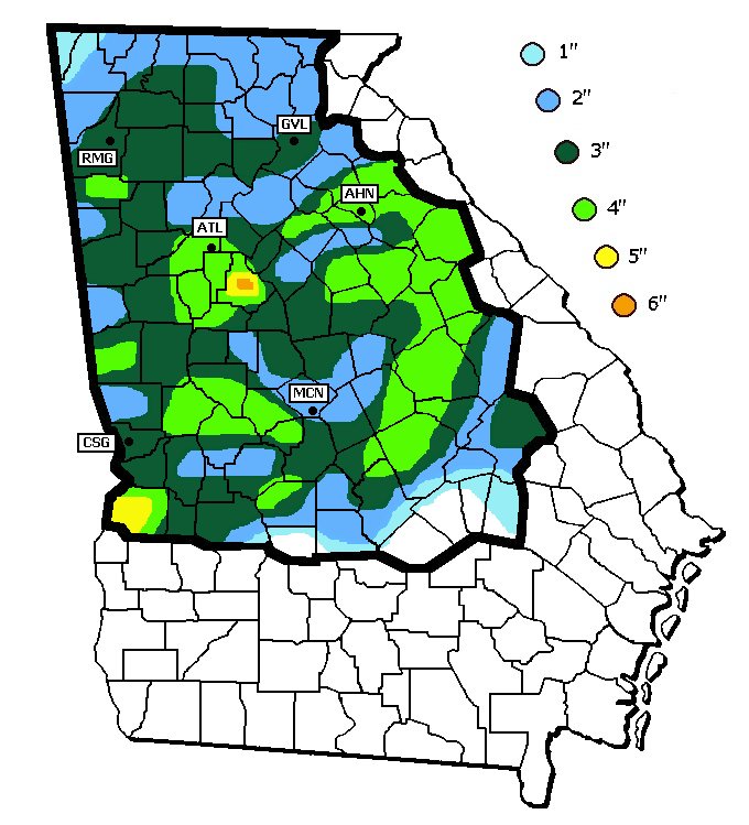
On Friday, February 12th, precipitation associated with a surface low tracking across the Gulf of America and an upper level short wave tracked across much of north and central Georgia. Light snow began over portions of west Georgia around noontime, then spread eastward through the afternoon before tapering off to flurries by mid evening and dissipating by early Saturday morning. Snow and slush on the roadways froze overnight leading to hazardous driving conditions late Friday night into Saturday morning. The map below shows the snowfall amounts across north and central Georgia.
| Map of Snowfall Amounts |
 |
Current Hazards
Submit Storm Report
Outlooks
Georgia Road Conditions
Nationwide
Local Storm Reports
Local
Forecasts
Activity Planner
Recreational Forecast
Fire Weather
Forecast Discussion
Incident Support
Tropical Weather
Local
Computer Models
Graphical
Aviation Weather
Current Weather
Maps
Rivers/Lakes
Satellite Images
Observations
Radar Imagery
Peachtree City
Regional Loop
Nationwide
Warner Robins
US Dept of Commerce
National Oceanic and Atmospheric Administration
National Weather Service
Atlanta/Peachtree City, GA
4 Falcon Drive
Peachtree City, GA 30269
770.486.1133
Comments? Questions? Please Contact Us.

