Atlanta/Peachtree City, GA
Weather Forecast Office
March 26-28th, 2009 |
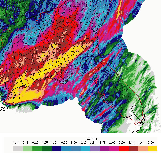
A prolonged period of unsettled weather brought heavy rain and isolated severe storms to the state from Thursday, March 26th to Saturday night, March 28th. The stormy event began when a weak frontal boundary stalled across north Georgia Thursday afternoon. The cold front and a warm, moist, unstable airmass south of the front provided the focus and fuel for numerous showers and thunderstorms as a series of upper disturbances continued to traverse the state through late Saturday. Periods of heavy rain on Thursday and again on Friday set the stage for flood problems as 1 to 3 inches of rainfall saturated the area before the climaxing weather system was to occur on Saturday. Computer forecast models had given indications of a possible heavy rain event earlier in the week, so forecasters took heed and posted a flood watch for north and most of central Georgia by early Wednesday morning, March 25th. By early Saturday morning, a strong upper level low and associated cold front had pushed into the lower Mississippi valley with numerous strong storms developing out ahead. A large area of showers and strong thunderstorms began to push into northwest and west central Georgia by early Saturday morning, then spread eastward across the state through Saturday evening. Some storms became severe on Saturday, producing damaging winds and large hail as they tracked eastward across parts of north and central Georgia. The cold front pushed across the state late Saturday evening and finally brought an end to the unsettled weather as a cool and much drier aimass spread into the state by Sunday morning. Overall, from Thursday through late Saturday, 2 to 5 inches of rain had fallen across north and central Georgia. The heavy rainfall caused significant runoff into streams and rivers, resulting in minor flooding for numerous rivers across the state by Sunday.
| Map of Rainfall Amounts for March 26-28th, 2009 |
 |
Current Hazards
Local Storm Reports
Local
Submit Storm Report
Outlooks
Georgia Road Conditions
Nationwide
Forecasts
Graphical
Aviation Weather
Activity Planner
Recreational Forecast
Fire Weather
Forecast Discussion
Incident Support
Tropical Weather
Local
Computer Models
Current Weather
Observations
Maps
Rivers/Lakes
Satellite Images
Radar Imagery
Nationwide
Warner Robins
Peachtree City
Regional Loop
US Dept of Commerce
National Oceanic and Atmospheric Administration
National Weather Service
Atlanta/Peachtree City, GA
4 Falcon Drive
Peachtree City, GA 30269
770.486.1133
Comments? Questions? Please Contact Us.

