The center of circulation associated with the remnants of Danny passed over the northern portion of Metropolitan Atlanta on the morning of July 23, 1997. Wind-related damage occurred that morning in Cobb County near Kennesaw State University. A storm survey team from the National Weather Service Forecast Office in Peachtree City visited the site and filed the following report:

Storm Survey:Kennesaw State University on July 23, 1997.
Synoptic Background: The remnants of Hurricane Danny, which made landfall in south Alabama on Saturday July 19, moved slowly across the Atlanta metropolitan area in the early morning hours of July 23rd. At 5 pm Tuesday July 22nd, as the remnants of Danny approached north Georgia, a Flash Flood Watch was issued for an area north of a line from Peachtree City in Fayette County to Athens in Clarke County on Tuesday July 22nd. This area was extended south to a line from Hamilton in Harris County to Forsyth in Monroe County to Eatonton in Putnam County to Washington in Wilkes County at 10 pm Tuesday evening. During the early morning hours on the 23rd, bands of heavy showers and thunderstorms moved through the metropolitan Atlanta area.
The main concern as these storms moved slowly through the area was flooding and flash flooding situations. Twenty-four hour rainfall totals at 7 am Wednesday revealed that parts of metropolitan Atlanta had received upwards of 5 and 1/2 inches of rainfall. The Peachtree City WSR-88D radar measured storm-related wind velocities of between 36 and 49 knots (42 to 57 miles per hour). A brief 50 to 63 knot (58 to 73 mile an hour) wind speed was detected at an altitude of about 3 thousand feet as the storms passed through northern Douglas County (just west of Cobb County).
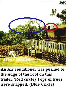
Storm Survey: A severe thunderstorm associated with the convective rain bands from the remnants of Danny passed over Kennesaw State University in Cobb County at approximately 6 am on July 23rd. Campus police officers reported a big boom which lasted for a couple of minutes at approximately 6:10 am. Trees were reported down at the Administration Building, as well as at the main entrance. Numerous trees were down on Chastain Road, at the intersection of Paulding Avenue and Dallas Drive, on Cobb Avenue, and at the intersection of Dallas Drive and Frey Lake Road. Power lines were also knocked down by falling tree limbs on Frey Lake Road and Dallas Drive. Across the street from the campus on Frey Lake Road lives a Ms Smiley. Ms Smiley was sitting at her breakfast table when the incident occurred. The time was 6:14 am according to this witness. Several trees were knocked down around Ms Smiley's home. Although most of the trees on this side of the administration building were facing southwest, the trees which were down on Ms Smiley's property and on the land between Frey Lake and Dallas Drive were facing northeast. A witness reported that the trees were blown to the southwest by the winds, but then snapped facing northeast once the wind had died down. Lieutenant Mark Parish with the KSU campus police reported that several pieces of equipment on the roof were either blown off the roof, or at least blown over. An air conditioning unit was pushed to the edge of a trailer. A vehicle sustained damage from the flying debris.
By Patricia Hart, Frank Taylor and Michael Clair