[Below is an archived article from late 2015. Information contained therein is not current.]
Potential Impacts of Record-Breaking El Niño for North and Central Georgia
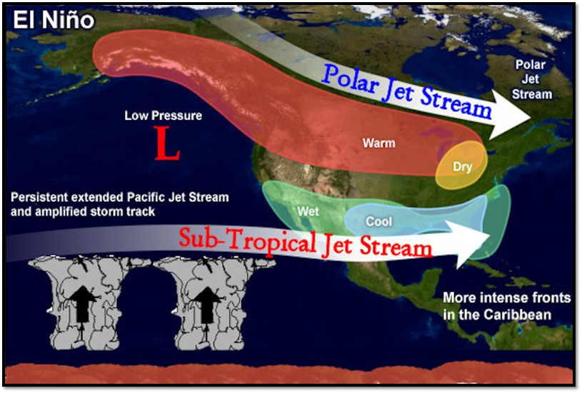
While pegged to have the strongest El Niño since 1997-1998 and potentially reach record-breaking status, there is growing concern as to what impacts could be felt across North and Central Georgia this coming winter and spring. To start out, it’s important to be familiar with what’s actually happening. By definition, El Niño marks abnormally warm sea surface temperatures across the eastern and central portions of the tropical Pacific (at least +0.5 degrees Celsius above normal), which triggers an atmospheric response. Essentially the increased heat energy of the ocean results in a shift of the nearby weather circulations. This in turn can alter the jet stream pattern that affects storm tracks across the U.S., an influence more typically seen in the cool season. One of the big players for us would be the sub-tropical jet setting up across the Southeast - something we have already seen enough of this fall.

Yes, we typically have wetter than normal conditions and cooler farther south with El Niño in general, but what could a potentially record-breaking El Niño mean? To put it in perspective, the critical part of the Pacific is already reaching over 2.5 degrees above normal (more than five times the minimum threshold)! Taking a trip back through time, we analyzed the last five strongest El Niño periods on record since 1950 and boiled down the effects on the corresponding winters and following springs along with key events in an interactive storymap:
Overall, the majority of periods were indeed wetter than normal – even the following springs (including significant flooding events in March of ’98). This is not good news, considering how the area has already been dealing with multiple flooding events this fall, which has left much of the ground highly saturated. Temperature was more variable in the winters, however aside from ’98, all other periods marked cooler than normal springs. How about snow? Observations show it’s also highly variable in such periods, though significant events included a late season heavy snow in March of ’83 and the snowiest winter on record for Columbus and Macon in ’72-‘73. Atlanta may have dodged the snow that year, although was hit instead by a crippling ice storm in early January.
Severe weather was prevalent in both the springs of ’98 and ’73 (a blockbuster of warnings issued in ’98), including more frequent quick spin-up tornadoes across southern portions of the state (mostly F0-F1 category). Such observations fall in line with the idea of the sub-tropical jet typically focusing the tracks of storm systems across the region. Stronger tornadoes have occurred as well, including the devastating Gainesville tornado of March ’98 causing F3 damage and 12 fatalities. While spring is more favorable for severe weather and stats from both strong and weak El Niño winters indicate a fairly consistent 30% decrease in Georgia tornadoes, serious winter tornado outbreaks have occurred. “For example, on December 2, 2009, during a moderately strong El Niño winter, a storm system produced seven tornadoes in Georgia. The strongest of which was an EF2 that injured two people and destroyed several homes in Appling County,” according to Dan Darbe, senior meteorologist with the National Weather Service.
Whether we’re more likely to have an ice storm, snow storm, significant flooding or severe weather outbreak, it’s all up for grabs. History has shown that all have happened with different strong El Niño periods in the past. There is a better chance the sub-tropical jet will allow for above normal moisture off the northern Gulf of America, although greater uncertainty exists with what disturbances or air masses may interact. “A single event cannot be directly attributed to a larger scale climate cycle like El Niño, though such a pronounced feature can very well increase the likelihood of having one impact the area,” says Adam Baker, meteorologist with the National Weather Service. There are multiple other patterns and influences occurring in our hemisphere that can contribute to impacts felt in Georgia. Separate from El Niño, the oscillating strength of the pressure systems in the Arctic and North Atlantic (referred to respectively as the AO and NAO indices) can allow for differences in the amount of cold polar air able to surge southward along with the likelihood of having precipitation. The problem is that the skill in forecasting these only goes out two weeks, so good luck estimating an overall influence for the upcoming seasons. Other upstream factors that are being monitored are the extent of Siberian fall snow cover (hypothesized to influence how cold the dips in the polar jet stream can get across the U.S. during the winter) and the recently observed abnormal warming of the northeast Pacific (which may further enhance typical El Niño effects). Needless to say, there is no clear “smoking gun” when it comes to answering what type of impactful weather we may have, and is usually a combination thereof.
The main transition to an El Niño came by no surprise to local meteorologists this past spring, but the degree of it this winter could be unprecedented. "El Niño had been dragging it's feet the last year and a half, but it looks like it is more than making up for it's previous lack of presence", states Baker, who also indicated they usually last a year to year and a half. Georgia residents are encouraged to remain alert this winter and following spring for threatening weather, and always be prepared to protect life and property.
Additional resources:
Current conditions from the Climate Prediction Center
Data prepared by the Atlanta NWS Forecast Office