
Record setting heat is expected over the next several days from the Intermountain West through the northern Plains. Furthermore, fire weather concerns increase with dry and breezy conditions. Meanwhile, heavy rainfall and severe thunderstorm threats for the Ohio/Tennessee Valleys, central Appalachians and Southeast today. The threat shifts to central Gulf Coast and across central Texas this week. Read More >
.PNG)
373
FPZS50 NSTU 160811
ZFPPPG
Zone Forecast Product for American Samoa
National Weather Service Pago Pago AS
911 PM SST Wed Jul 15 2026
ASZ001>004-161530-
Tutuila-Aunuu-Manua-Swains Island-Rose Atoll-
911 PM SST Wed Jul 15 2026
...A Wind Advisory remains in effect...
...A High Surf Advisory remains in effect...
.REST OF TONIGHT...Breezy. Partly cloudy. Isolated showers. Lows
around 75. Southeast winds 20 to 25 mph with higher gusts.
.THURSDAY...Breezy. Mostly sunny. Isolated showers. Highs around
80. Southeast winds 20 to 25 mph with higher gusts.
.THURSDAY NIGHT...Windy. Partly cloudy. Isolated showers. Lows
around 75. Southeast winds 20 to 30 mph with higher gusts.
.FRIDAY THROUGH SATURDAY...Windy. Partly cloudy. Isolated showers.
Highs around 80. Lows in the mid 70s. Southeast winds 20 to 30
mph with higher gusts.
.SATURDAY NIGHT THROUGH MONDAY...Breezy. Mostly cloudy. Scattered
showers. Lows in the mid 70s. Highs in the lower 80s. East winds
15 to 25 mph.
.MONDAY NIGHT THROUGH WEDNESDAY...Mostly cloudy. Numerous
showers. Lows in the upper 70s. Highs in the mid 80s. East winds
15 to 20 mph.
$$
Tides at Pago Pago Harbor
LOW tide at 230 AM Thu -0.3 FT
HIGH tide at 854 AM Thu 3.3 FT
LOW tide at 312 PM Thu -0.4 FT
HIGH tide at 924 PM Thu 2.8 FT
Tides at Tau Harbor
LOW tide at 206 AM Thu -0.3 FT
HIGH tide at 829 AM Thu 4.7 FT
LOW tide at 248 PM Thu -0.4 FT
HIGH tide at 859 PM Thu 4.0 FT
Sunrise Thu...649 AM Sunset Thu...611 PM
The next scheduled forecast will be issued at 700 am SST
For other forecast and model data, go to our web page at
http://www.weather.gov/ppg
&&
Tala o le Tau mo Amerika Samoa
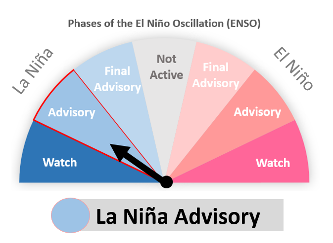
...O loo tumau le Fautuaga mo Savili Malolosi...
...O loo tumau le Fautuaga mo Galu Maualuluga...
.VAEGA O LE PO O TOTOE...E savilivili. E auaoa i nisi o taimi. E
ta`ape nai timu. Malu e 75. Savili mai saute i sasa`e 20 i le 25
mph ma e faata`utau.
.ASO TOFI...E savilivili. E auaoa i nisi o taimi. E ta`ape nai
timu. Vevela e 80. Savili mai saute i sasa`e 20 i le 25 mph ma e
faata`utau.
.PO ASO TOFI...E savili. E auaoa i nisi o taimi. Malu e 75.
Savili mai saute i sasa`e 20 i le 30 mph ma e faata`utau.
.ASO FARAILE MA LE ASO TOONA`I...E savili. E auaoa i nisi o
taimi. Vevela e 80. Malu e 75. Savili mai saute i sasa`e 20 i le
30 mph.
.PO ASO TOONA`I E OO I LE ASO GAFUA...E savilivili. E matele ina
auaoa. E taape solo timu. Malu e 75. Vevela e 83. Savili mai
sasa`e 15 i le 25 mph.
.PO ASO GAFUA E OO I LE ASO LULU...E matele ina auaoa. E toulu
timuga. Malu e 78. Vevela e 84. Savili mai matu i sasa`e 15 i le
20 mph.
$$


 mPING (Ripoti mai Tala o le Tau)
 Pacific Tsunami Warning Center (PTWC)
 Previous 36hrs Airport Obs (Vaaiga o le Tau i le Malae Vaalele)
 Submit a Storm Report (Ripoti mai le Tau)
 Sunrise/Sunset Info (Oso/Goto le La)
 Tides Info (Tala o le Tai)