
Record setting heat is expected over the next several days from the Intermountain West through the northern Plains. Furthermore, fire weather concerns increase with dry and breezy conditions. Meanwhile, heavy rainfall and severe thunderstorm threats for the Ohio/Tennessee Valleys, central Appalachians and Southeast today. The threat shifts to central Gulf Coast and across central Texas this week. Read More >
Central Illinois
Weather Forecast Office
Tornado #7
Greene/Scott/Morgan Counties
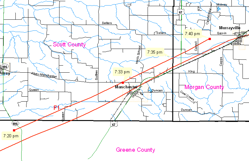
While investigating the track of the 66-mile-long tornado path, survey teams from the Lincoln and St. Louis NWS offices were able to uncover a separate tornado track, just north of the main track.
This tornado developed in north central Greene County, along county road 2700N, 1/2 mile west of highway 106 (or about 1.5 miles west-northwest of Barow). It developed around 7:20 pm and moved northeast into southern Scott County. The tornado crossed the Alsey-Manchester Road, about 3/4 mile northwest of Manchester, around 7:33 pm., and continued northeast, crossing the Scott/Morgan County line 2.75 miles west-southwest of Murrayville around 7:35 pm. It finally lifted about 1.25 miles west of Murrayville at 7:40 pm.
The intensity of this tornado was determined to be F1, with a width of 75 yards and a path of 9.75 miles.
Event Links: Overview | Long-Track Tornado | Springfield | Franklin/Loami | Eastern Sangamon
Southern Logan | Greene/Scott #2 | Logan/Macon | Macon/De Witt | Radar&Satellite
US Dept of Commerce
National Oceanic and Atmospheric Administration
National Weather Service
Central Illinois
1362 State Route 10
Lincoln, IL 62656
217-732-7321 (forecast recording) or 217-732-3089
Comments? Questions? Please Contact Us.

