Lake Winnebago Forecast About these forecasts


|
|
|
Note: Experimental product. Check product creation time to verify this is a current forecast. |
|
Note: Check product creation time to verify this is a current product. |
228

ASUS43 KGRB 251559

RWRGRB


NORTH-CENTRAL AND NORTHEAST WISCONSIN REGIONAL WEATHER ROUNDUP

NATIONAL WEATHER SERVICE GREEN BAY WI

1100 AM CDT SAT JUL 25 2026


WIZ005-009-010>012-018-019-251700-

NORTH CENTRAL WISCONSIN


CITY           SKY/WX    TMP DP  RH WIND       PRES   REMARKS

IRONWOOD       CLOUDY    72  64  76 SW10      29.89S

MANITOWISH WTR NOT AVBL

ARBOR VITAE    CLOUDY    69  64  84 SW5       29.93S

EAGLE RIVER    NOT AVBL

LAND O LAKES   NOT AVBL

RHINELANDER    CLOUDY    70  63  78 SW8       29.94F

PHILLIPS       NOT AVBL

ANTIGO         NOT AVBL

TOMAHAWK       NOT AVBL

MERRILL        NOT AVBL

$$


WIZ013-073-251700-

NORTHEAST WISCONSIN


CITY           SKY/WX    TMP DP  RH WIND       PRES   REMARKS

IRON MOUNTAIN  CLOUDY    72  63  73 S8        29.90F

MARINETTE      NOT AVBL

$$


WIZ017-030-035>037-045-251700-

CENTRAL WISCONSIN


CITY           SKY/WX    TMP DP  RH WIND       PRES   REMARKS

MEDFORD        CLOUDY    70  64  82 W5        29.95R

WAUSAU         CLOUDY    71  63  75 VRB5      29.94S

MOSINEE        NOT AVBL

MARSHFIELD     CLOUDY    72  65  78 SW8       29.94S

WISC RAPIDS    CLOUDY    73  64  73 SW6       29.95S

STEVENS POINT  NOT AVBL

WAUPACA        NOT AVBL

SHAWANO        NOT AVBL

CLINTONVILLE   NOT AVBL

WAUTOMA        CLOUDY    73  64  73 S7        29.95F

$$


WIZ038-039-048-051-251700-

FOX VALLEY


CITY           SKY/WX    TMP DP  RH WIND       PRES   REMARKS

NWS GREEN BAY  CLOUDY    70  64  81 SW12G18   29.95S

APPLETON       CLOUDY    70  64  83 SW9       29.97F

OSHKOSH        CLOUDY    70  62  76 S9        29.96F

FOND DU LAC    CLOUDY    70  61  73 S13       29.98F

$$


WIZ022-050-052-251700-

EAST CENTRAL WISCONSIN


CITY           SKY/WX    TMP DP  RH WIND       PRES   REMARKS

EPHRAIM        NOT AVBL

WASHINGTON ISL NOT AVBL

STURGEON BAY   NOT AVBL

MANITOWOC      CLOUDY    75  64  68 SW8       29.97F

SHEBOYGAN      CLOUDY    75  61  61 S14       29.98F

$$


LMZ563-521-522-541>543-251700-

LAKESHORE


STATION/POSITION TIME  TEMP    WIND        PRES    VSBY  WAVE

                       AIR SEA DIR/SP/G                  HT/PER

                 (UTC) (F)     (DEG/KT/KT) (MB)    (MI)  (FT/S)

SHEBOYGAN LKSHOR 1500   68     170/ 12/ 13 1015.8R

KEWAUNEE LKSHORE 1506          180/ 11/ 12 1014.0

NORTHPORT PIER   1500          110/ 10/ 11 1014.2

N MID LAKE BUOY  1540   62 61  190/ 12/ 14 1013.7R

MENOMINEE LKSHOR 1506   70 66  210/ 12/ 16 1013.4

$$
|
Note: Check data times to verify information is current. |
Lake Winnebago Buoy
- INFOS WinnGB Project
Lake Winnebago Water Temperatures
- Latest hourly reading
- Last 21 days
- Daily stream water temps -- See bottom of report; including Lk Winnebago
|
|
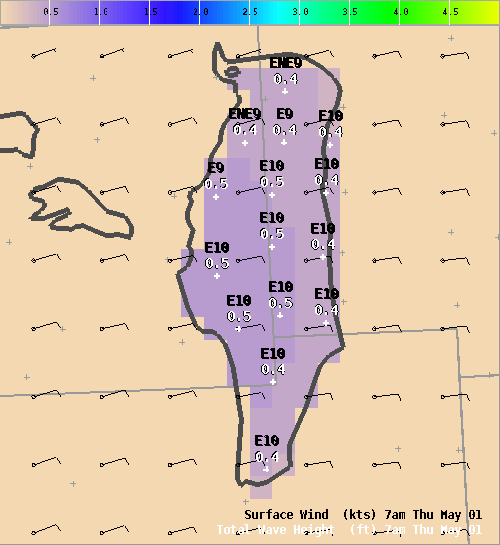
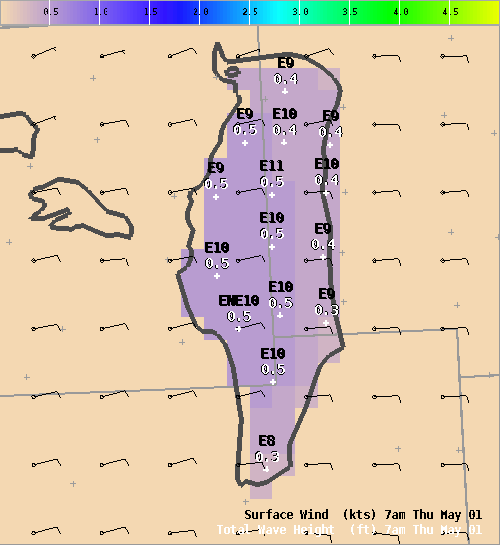
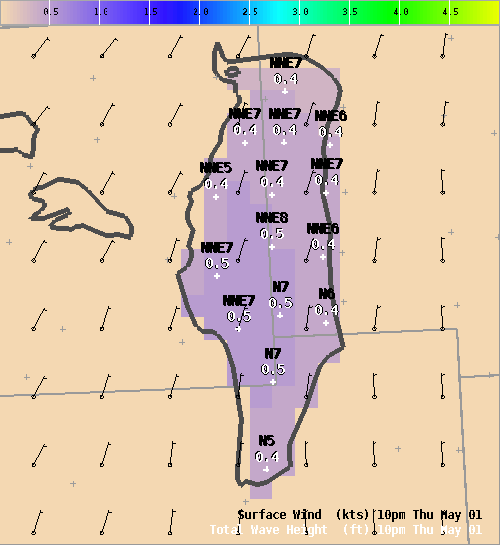
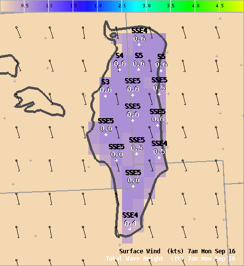
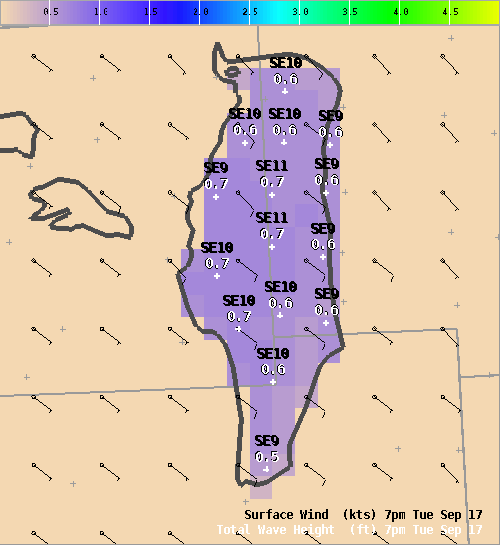
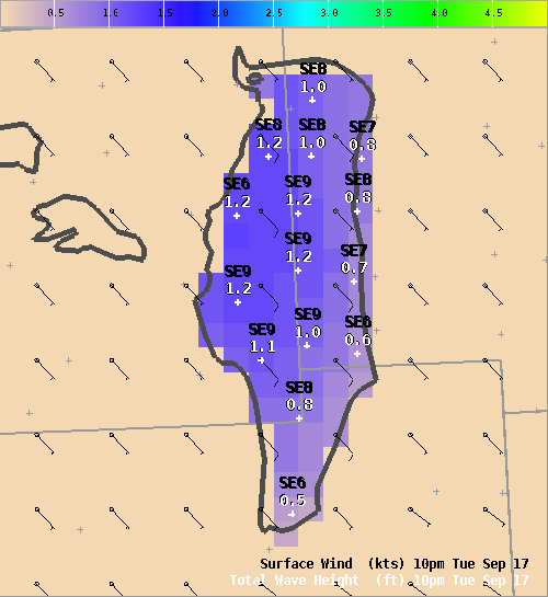
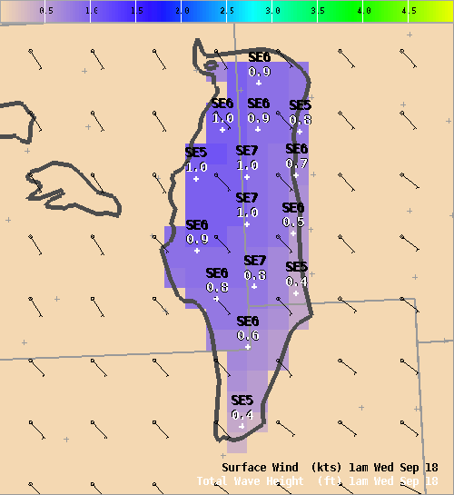
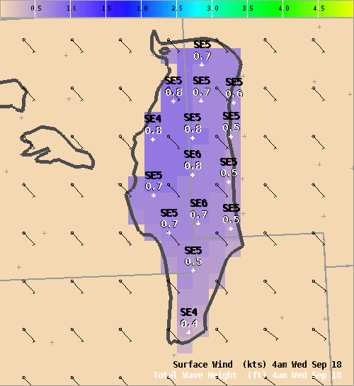
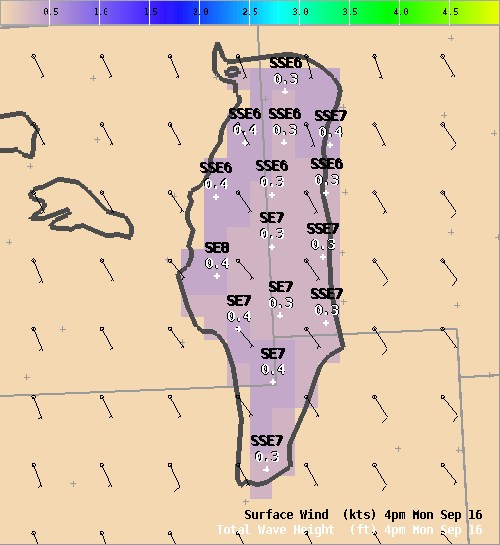
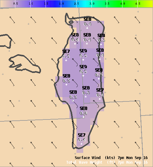
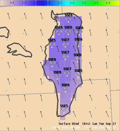
This forecast is available during the boating season, usually April through the end of October. The forecast, both graphical and text, is generated several times per day with updates made when weather conditions become unrepresentative. Use with caution. Be sure to check the product creation time to verify that the forecast you are viewing is current. Forecasts are valid for either 36 or 48 hours dependent on issuance time. Forecast elements include winds, significant wave heights, sensible weather, and associated restrictions to visibility if applicable over the open lake waters.
A wave model is run by NWS in Green Bay which produces the wave height forecast for Lake Winnebago. Forecasters at NWS Green Bay develop the wind forecast that is used in the wave model. The wave model has been used on the Great Lakes and has been shown to do reasonably well.
The latest observations for sites along the lake are also being provided. You may ask “Are these really the kind of winds you can expect on the open area of a lake or reservoir?” Any lake recreationalist will probably tell you that the winds are often found to be stronger than what was forecast or seen at the surrounding observation sites. Studies have shown that there is approximately a 4 to 5 mph increase in sustained wind speeds on open bodies of water compared to the nearest airport. Keep in mind that this difference is over an open waterway and is not necessarily what one would find if they were boating in a protected pocket of the waterway or near a wind protected structure such as a tree line, an island or point.
Click here for more answers to some questions you may have regarding the Lake Winnebago Recreational Forecast.
We greatly value your input into ways to make the forecast and this website more useful. Please contact nws.greenbay@noaa.gov with any suggestions, comments or questions.