Lake Winnebago Forecast Frequently Asked Questions
1. What real-time marine weather information is available on the lake?
There are no weather observing platforms or buoys on Lake Winnebago. Real-time data for land sites nearby are available on our website, or by clicking here.
2. With no wave measurements on the lake, how do you forecast wave heights?
There are several methods available to the forecaster to forecast wave heights, including empirically derived wave heights from deep water wave/fetch nomograms. The most preferred method is through a locally run wave model from the Great Lakes Environmental Research Laboratory (GLERL). The model is run at a 2.5 km resolution, and is based on statistics developed from observed winds and wind fetch, and resulting wave heights. The model performs adequately under most circumstances for relatively short fetches such as exist over the Great Lakes. This evaluation period will determine how it does on the shallow waters of Lake Winnebago. As typical in other marine forecast products, the wave height values are expressed as significant wave height.
3. What is significant wave height?
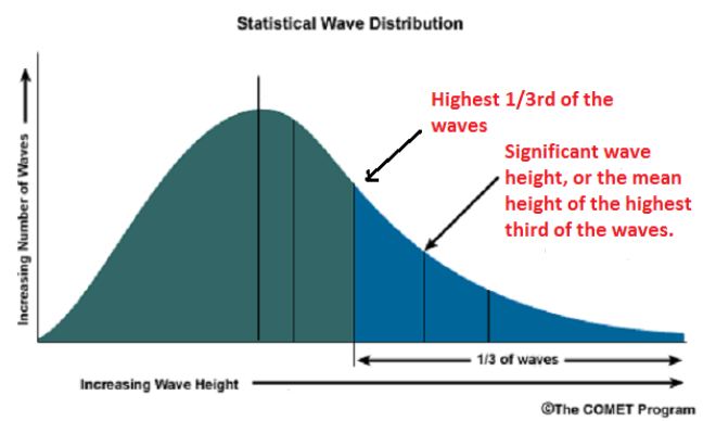
Significant wave height is generally defined as the mean or average wave height of the highest third of the waves (see figure below). This is the height that an experience observer will see. Another important point is that a small percentage of waves may actually exceed the significant wave height such that the maximum potential wave may approach twice this height. For example, if a steady state wind is blowing at 22 knots, we may forecast waves in the 1 to 3 foot range. However, many waves will be a foot or less and a few may reach 4 to 5 feet. This variability may be even more pronounced under rapidly changing conditions, especially over more expansive areas of open water such as the ocean.
 |
| Diagram highlighting the concept of significant wave height. |
4. Is the wave model accurate?
For the most part it is, on the Great Lakes, but is very dependent on correctly forecasting the winds on the lake and capturing the lake surface temperatures. The model may also underperform in smaller bays and near shore waters, where fine-scale current and/or frictional effects/shallow waters are more difficult to resolve.
5. Your forecasts are generally good, but for certain locations on the lake they seem less accurate. Why?
This was addressed somewhat in discussing significant wave height above. The primary areas in which forecasts tend to drift from reality is in the near shore waters and in the smaller bays. Why? The main reason is due to small-scale currents and land/water frictional effects that typically occur in these locations where the wind may be blocked or channeled. These small-scale effects are often not resolved well by the wind forecasts and wave models due to resolution (2.5 km) issues. In these cases, applying local knowledge to the existing forecast may aid the mariner substantially. In other small bays the model may perform quite well.
6. Why do I see differences in the text and graphical forecasts?
The answer is fairly straightforward. The worded forecast is produced by a computerized text formatter that samples the entire lake to produce “average” conditions of winds, waves, weather, etc.
7. Why do winds typically blow stronger over the lake during fall?
This all has to do with turbulent or mechanical mixing of the atmosphere. Typically in the fall the waters of the lake are warmer than the surrounding air. Sure, the water temperature is cooler than in the summer, so “warmer” is a relative term. Nonetheless, when the water is warmer than the air, the lower 500 to 1,500 feet of the atmosphere over the lake becomes unstable such that higher momentum air aloft becomes mixed down to the surface. It is through this process that stronger winds are observed on the lake. The exact opposite occurs during the early spring when air temperatures begin to rise, but the lake waters remain cold. In this scenario, the colder lake waters actually produce a stable layer of air in the lower levels, thus inhibiting the turbulent mixing process and resulting in lighter winds.
Click here to go back to the Lake Winnebago forecast page.