|
A historical event unfolded across the central United States on 12/15 as a strong storm system tracked across the central Plains and up across the Upper Mississippi Valley. Record warmth was observed across the state of Wisconsin ahead of this system, as temperatures soared into the 60s. A few locations across southwest Wisconsin even saw temperatures warm into the lower 70s. Strong wind gusts of 55 to 75 mph were observed as a weakening line of thunderstorms moved into central Wisconsin. Peak winds created pockets of tree damage and numerous power outages, leaving over 50,000 people without power in northeast Wisconsin, and over 100,000 across the entire state. The storm system was so powerful, it even transported smoke from numerous large wildfires from western and central Kansas all the way up into Wisconsin! There were reports of seeing haze from the smoke and some were even able to smell a hint of smoke in the atmosphere. Visit our neighboring offices Top New Articles: La Crosse & Milwaukee
Please see tabs below for more information. Click on any image/animation for a larger view. |
|
Peak Wind Reports
.png)
...HIGHEST WIND GUSTS...

LOCATION                     SPEED     TIME/DATE       PROVIDER
RHINELANDER AIRPORT          76 MPH    0249 AM 12/16   ASOS
MARSHFIELD AIRPORT           74 MPH    0146 AM 12/16   AWOS
FOREST JUNCTION              71 MPH    1219 AM 12/16   CWOP
WISCONSIN RAPIDS AIRPORT     69 MPH    1011 PM 12/15   ASOS
WAUSAU AIRPORT               62 MPH    0218 AM 12/16   ASOS
STURGEON BAY AIRPORT         62 MPH    0441 AM 12/16   AWOS
SISTER BAY 1 NNW             61 MPH    0456 AM 12/16   CWOP
GREEN BAY AIRPORT            60 MPH    0254 AM 12/16   ASOS
MARSHFIELD                   60 MPH    1000 PM 12/15   MESOWEST
OSHKOSH AIRPORT              58 MPH    1111 PM 12/15   ASOS
MOSINEE AIRPORT              55 MPH    0335 AM 12/16   AWOS
MANITOWOC AIRPORT            55 MPH    0416 AM 12/16   AWOS
MERRILL AIRPORT              55 MPH    0235 AM 12/16   AWOS
STEVENS POINT AIRPORT        55 MPH    0235 AM 12/16   AWOS
KEWAUNEE MET, WI             55 MPH    0306 AM 12/16   NOS-NWLON
WAUTOMA AIRPORT              55 MPH    0308 AM 12/16   AWOS
MENOMINEE                    55 MPH    0436 AM 12/16   NOS-NWLON
MANITOWOC                    53 MPH    0436 AM 12/16   CWOP
ANTIGO AIRPORT               53 MPH    0315 AM 12/16   AWOS
PHELPS 2 SW                  53 MPH    1202 AM 12/16   RAWS
CLINTONVILLE AIRPORT         52 MPH    0135 AM 12/16   AWOS
SHAWANO AIRPORT              52 MPH    0355 AM 12/16   AWOS
DE PERE                      51 MPH    0400 AM 12/16   CWOP
REEDSVILLE                   51 MPH    0115 AM 12/16   CWOP
APPLETON AIRPORT             51 MPH    0335 AM 12/16   AWOS
OCONTO AIRPORT               51 MPH    0455 AM 12/16   AWOS
WAUPACA                      51 MPH    0335 AM 12/16   AWOS
BREED 5 NE                   51 MPH    0403 AM 12/16   RAWS
WRIGHTSTOWN                  50 MPH    1248 AM 12/16   CWOP
MERRILL                      50 MPH    0216 AM 12/16   CWOP
TOMAHAWK 3 W                 50 MPH    0310 AM 12/16   RAWS
EAGLE RIVER AIRPORT          49 MPH    0315 AM 12/16   AWOS
ANTIGO 2 ENE                 48 MPH    0605 AM 12/16   RAWS
PLOVER                       48 MPH    0216 AM 12/16   CWOP
WABENO 2 NNW                 48 MPH    0401 AM 12/16   RAWS
SEYMOUR                      47 MPH    0515 AM 12/16   CWOP
MANITOWOC                    47 MPH    0345 AM 12/16   CWOP
WHITELAW                     47 MPH    0145 AM 12/16   CWOP
CHILTON 1 W                  46 MPH    0109 AM 12/16   AWS
GREENVILLE                   45 MPH    0206 AM 12/16   CWOP
GREEN BAY                    45 MPH    0315 AM 12/16   CWOP
WINCHESTER                   43 MPH    0255 AM 12/16   CWOP
TWO CREEKS                   43 MPH    0335 AM 12/16   CWOP
EPHRAIM                      43 MPH    0615 AM 12/16   AWOS
RHINELANDER                  43 MPH    1100 PM 12/15   MESOWEST
WAUTOMA 1 WSW                43 MPH    0312 AM 12/16   RAWS
KESHENA 2 WNW                42 MPH    0505 AM 12/16   RAWS
MOON 6 SW                    42 MPH    0505 AM 12/16   RAWS
ATHELSTANE 2 SW              41 MPH    0415 AM 12/16   CWOP
GREEN BAY                    41 MPH    0401 AM 12/16   CWOP
ARBOR VITAE AIRPORT          41 MPH    0315 AM 12/16   AWOS
APPLETON                     41 MPH    0107 AM 12/16   RAWS
GREEN BAY 1 N                40 MPH    0400 AM 12/16   NDBC
WASHINGTON ISLAND            40 MPH    0435 AM 12/16   AWOS
MOUNTAIN                     39 MPH    0408 AM 12/16   CWOP
NEW ROME 4 ENE               39 MPH    0105 AM 12/16   RAWS
EGG HARBOR 3.1 SE (MAWN)     39 MPH    0900 AM 12/16   MESOWEST
GREEN BAY                    38 MPH    0350 AM 12/16   CWOP
GRAND CHUTE                  38 MPH    0108 AM 12/16   CWOP
MANITOWISH WATERS AIRPORT    38 MPH    0335 AM 12/16   AWOS
HANCOCK 1.4 SW (MAWN)        37 MPH    0200 AM 12/16   MESOWEST
DE PERE                      36 MPH    0115 AM 12/16   CWOP
LAND O LAKES                 36 MPH    0255 AM 12/16   AWOS
LARSEN 4 ENE                 36 MPH    0404 AM 12/16   AWS
1 ENE GILLS ROCK             36 MPH    0840 AM 12/16   NDBC
WAUSAUKEE 2 NW               36 MPH    0505 AM 12/16   RAWS
OMRO                         35 MPH    0306 AM 12/16   CWOP
VESPER                       35 MPH    0151 AM 12/16   CWOP
MANITOWOC                    35 MPH    0355 AM 12/16   CWOP
NEW HOLSTEIN 1 W             35 MPH    0335 AM 12/16   AWS
WAUSAU                       34 MPH    0341 AM 12/16   CWOP
STANGELVILLE 0.8 E (MAWN)    34 MPH    0200 AM 12/16   MESOWEST
MAPLEWOOD 1.4 W (MAWN)       34 MPH    0200 AM 12/16   MESOWEST
STRATFORD 4 W                33 MPH    0205 AM 12/16   AWS
CRANDON                      33 MPH    0310 AM 12/16   CWOP
ELLISON BAY 2.2 S (MAWN)     33 MPH    0800 AM 12/16   MESOWEST
DENMARK 1 NNE                32 MPH    0335 AM 12/16   AWS
ARBOR VITAE - WOODRUFF 2 S   32 MPH    0610 AM 12/16   RAWS
SHAWANO 1 W                  31 MPH    0310 AM 12/16   AWS
APPLETON                     30 MPH    1120 PM 12/15   AWS
KAUKAUNA                     30 MPH    1130 PM 12/15   CWOP
CECIL                        30 MPH    0802 AM 12/16   CWOP
NEW LONDON 1 SW              30 MPH    0305 AM 12/16   AWS
LUXEMBURG 2.0 NE (MAWN)      30 MPH    0900 AM 12/16   MESOWEST

OBSERVATIONS ARE COLLECTED FROM A VARIETY OF SOURCES WITH VARYING
EQUIPMENT AND EXPOSURES. WE THANK ALL VOLUNTEER WEATHER OBSERVERS
FOR THEIR DEDICATION. NOT ALL DATA LISTED ARE CONSIDERED OFFICIAL.
How Rare Was This Event?
|
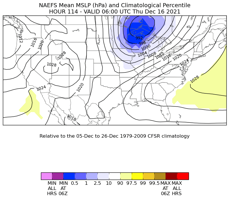
We can gauge how rare or anomalous a weather system is by comparing certain meteorological aspects of the event to climatology. This was quite unusual event for mid-December with respect to how warm and unstable the airmass was, how far north and widespread the severe convective weather traveled for early winter, and how widespread and intense the synoptic-scale winds accompanying the cyclone were. In this regard, let’s take a quick look how anomalous the max temperatures, instability (CAPE), wind speeds and mean sea level pressure (MSLP) were in this event. First, let’s look at the strength of the surface low pressure system. Figure 1 illustrates consecutive forecasts of a model ensemble average forecast MSLP all valid at midnight (06Z) Thursday December 16th. The colored (shaded) areas denote the forecast surface pressure and how it compares to 30 year climatology of surface pressure. What this animation tells us is that the surface pressure at that location and time was forecast to be lower than any surface pressure observed (at that location and time) over the past 30 years! We also observe that the ensemble forecasts were fairly consistent in forecasting anomalously low pressure near the Duluth, MN area for consecutive forecast cycles. This is valuable information as it helps the forecaster put into historical perspective the model forecast and more importantly, helps to message the potential impacts appropriately so that our core partners and the general public can prepare! |
|
|
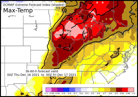
Naturally, the intensity of the surface cyclone would then also impact surface sensible weather elements such as temperature and wind. Figure 2 is a forecast that indicated how anomalous or extreme the daytime maximum surface temperatures would be over the western Great Lakes. Areas shaded in the pink colors are near 1 which suggests daytime highs are forecast to be extremely warm (rare) for mid-December. Many locations within the pink shaded areas shattered their daytime record highs. An unseasonably warm airmass over the western Great Lakes also implies potential for more instability. Figure 3 is the Extreme Forecast Index (EFI) for CAPE (a measure of instability). Again, we see EFI values of 1, indicating CAPE was forecast to be unusually high (rare) over the western Great Lakes for mid-December. This instability is what fed the intense, damaging wind and tornado-producing squall line. Finally, Figure 4 shows the EFI for forecast wind gusts. Again, we see EFI values very close to 1 (red & pink shades) from the Central Plains to the Great Lakes. In summary, the intense cyclone of December 15-16, 2016 was truly a rare event in terms of the cyclone strength and its impacts! |
|
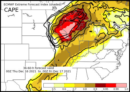 Figure 3 - ECMWF Extreme Forecast Index (EFI) for Instability (CAPE) |
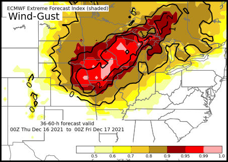 Figure 4- ECMWF Extreme Forecast Index (EFI) for Wind Gusts |
Environmental Overview
|
A deep 500mb trough associated with strong short-wave upper-level jet energy, organized over the western U.S. early on Wednesday December 15 and quickly moved northeast toward the upper Mississippi Valley by 6 am Thursday morning December 15th (Figure 5). Very strong upper-level divergence and vertical motion developed ahead of the shortwave energy leading to the rapid development of surface low pressure over eastern Colorado by midday Wednesday December 15th. The surface low rapidly intensified as it moved across the Central Plains into the upper Mississippi Valley (Figure 6). Take particular note of the explosive and expansive cloud development that initiated over the Central Plains as the system encountered unseasonably deep moisture and instability already in place in that area. Also note how the middle and upper-level clouds quickly wrap cyclonically (counterclockwise) around the rapidly intensifying upper-level circulation (Figure 7).
|
|
|
|
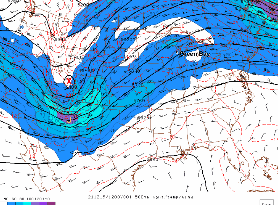
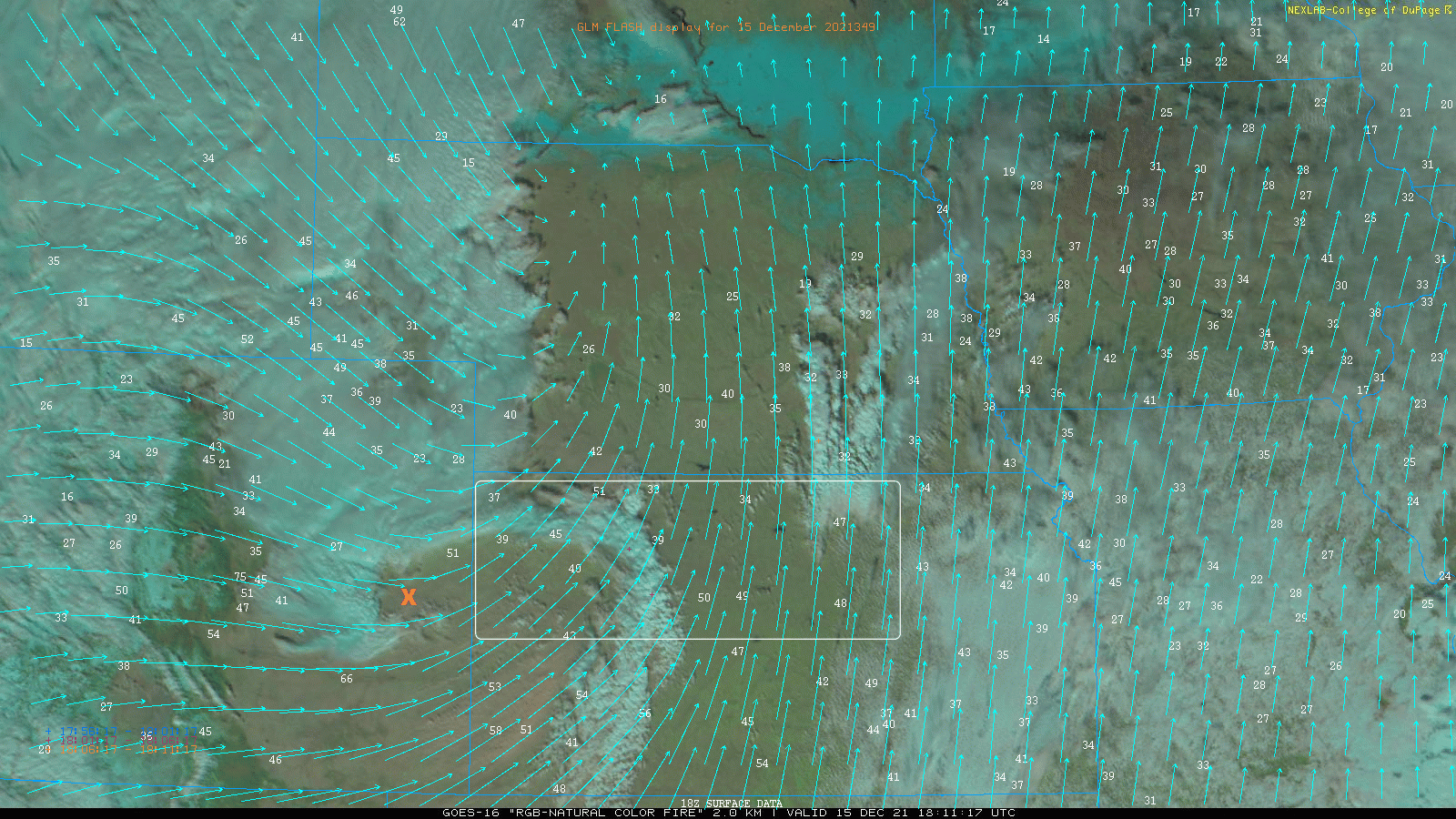
Let’s take a brief closer look at the initial explosive development over the Central Plains during the afternoon hours of Wednesday December 15th. The animation in (Figure 8) highlights the rapid early development of the system as it moved east from the eastern Colorado Plains area. First, note the explosive development of an extensive severe convective squall line with its associated lightning flashes. The squall line raced eastward at 55 to 65 mph and extended from Oklahoma northward to southeast South Dakota by the end of the loop. The squall line continued to race northeastward across Iowa, southeast Minnesota and central Wisconsin before weakening shortly before midnight. A staggering number of hurricane force wind gusts (> 75 mph) were reported with the squall line. In fact, preliminary results indicate that 45 such reports were received which would be a daily record, even surpassing the previous record (44 reports) on June 6, 2020 (Iowa Derecho). Keep in mind that this record was broken in the middle of December! Another interesting aspect illustrated in Figure 8 is the extreme wind gusts that occurred behind the initial squall line. Note the cyclonic swirl that moved off the Colorado Plains eastward into Kansas. The “X” denotes the approximate location of the low-level circulation center. Near the southern end or tail of the cyclonic swirl, locally higher wind gusts in excess of 80 mph are noted. These wind gusts likely knocked down power lines that initiated and exacerbated fires in central Kansas. The yellow circle near the end of the animation highlights hot spots associated with fires in that area as well as an 87 mph wind gust! |
|
|
|
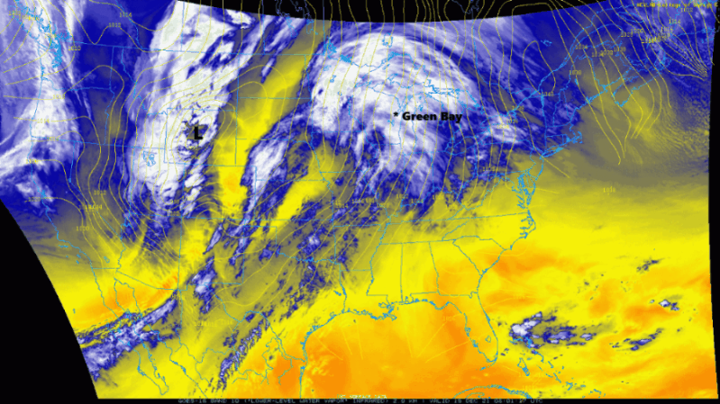
The already strong upper-level circulation continued to intensify as it approached the western Great Lakes region during the early morning hours of December 16th. Let’s take another look at this circulation as it moved across northern Wisconsin overnight. Figure 9 highlights specially enhanced composite nighttime infrared imagery referred to as the Airmass RGB. This imagery helps to reveal details in the cloud characteristics and general characteristics of the surrounding airmass. This enhancement provides somewhat of a 3D feel to the imagery. Deep and/or high clouds in the imagery appear whitish with a greenish hue, while lower level clouds appear in muted, darker cream tones. The brownish/amber hues in the imagery indicate drier air, while bluish hues suggest relatively higher moisture. Take particular note of the southern edge or tail of the circulation as it wraps southeast then eastward across northern Wisconsin in Figure 9. |
|
|
|
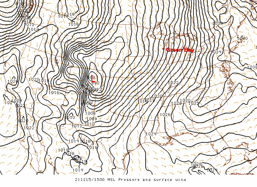
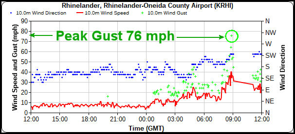
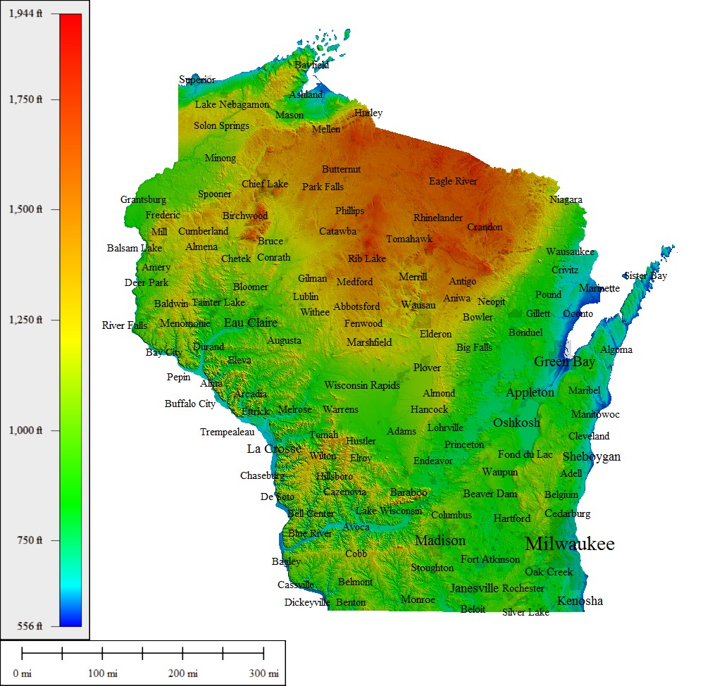
As we saw over central Kansas earlier in the day, we do see evidence of enhanced wind gusts near this cloud feature. The black line on the imagery represents the leading edge of the tail feature as it evolved and surges eastward across northern Wisconsin. As the cloud tail approached the Rhinelander, Wisconsin area (yellow circle), note the 66 mph wind gust. In fact, a peak wind gust of 76 mph was reported at the Rhinelander airport shortly before 3 am (Figure 10). This was the highest measured wind gust in Wisconsin during the entire event. Rhinelander is at an elevation of about 1600 ft AGL and therefore is somewhat more susceptible to stronger winds (Figure 11). The possible relationship between the 76 mph wind gust near Rhinelander and the aforementioned "tail" cloud feature in the enhanced GOES16 imagery is not well understood. With intense cyclones, excessive wind gusts have been known to occur near the tail of the comma head for various reasons, including a phenomenon referred to as a sting jet. Regardless of the possible cause, it is interesting to note the strong wind gusts observed near this tail feature over northern Wisconsin, and earlier in the day over central Kansas. |
|
|
|
This event was unique in that extreme wind gusts were associated, not only within localized severe convective storms accompanying a long-lived squall line, but also over a much broader region of non-convective wind gusts accompanying this rare and intense winter cyclone. |
|
Radar/Warnings
|
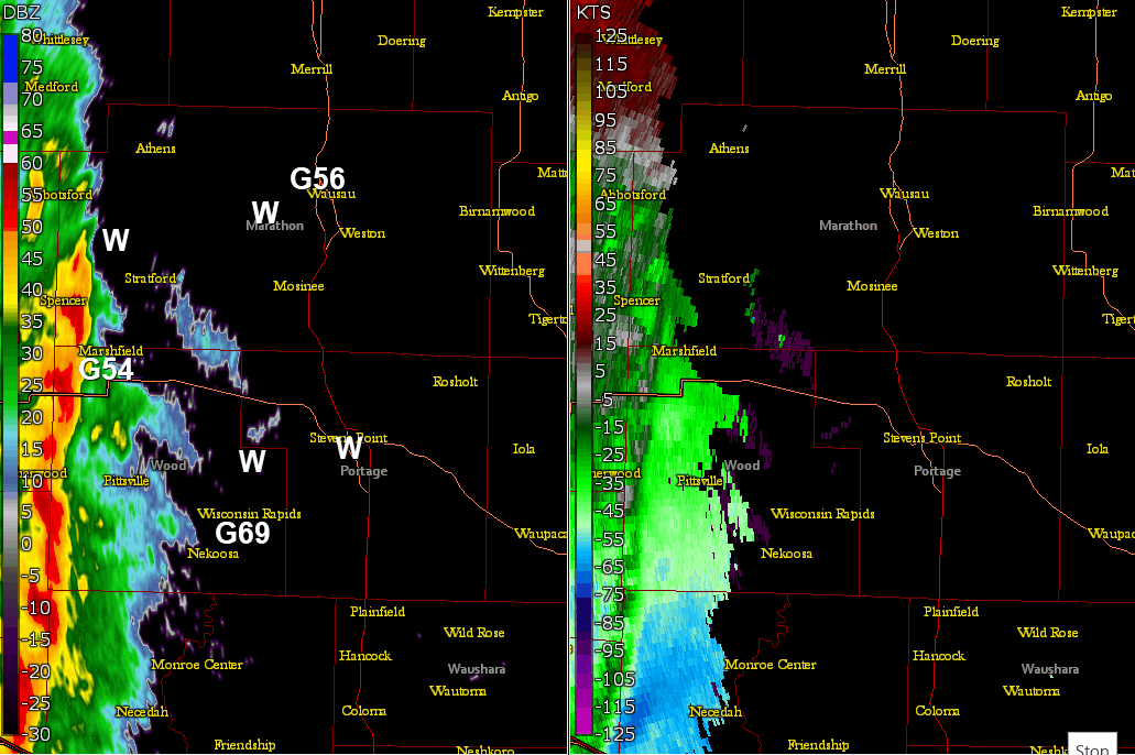
Green Bay WSR 88D 2-Panel Radar (Reflectivity left & Velocity right): 10-11 pm CST The radar animation shows a rare severe squall line racing east across parts of central Wisconsin late in the evening of Wednesday December 15th. Several reports of wind gusts of 50-70 mph and scattered tree damage were reported. Some structural damage also occurred where siding and shingles were blown off and/or where trees fell on a few homes. The damage was associated with straight-lines winds that occurred in association with small embedded bowing structures. The velocity animation on the right, denotes small-scale enhanced velocity surges (darker blue shades denoted by the arrows) that were associated with most of the reported wind damage. |
|
|
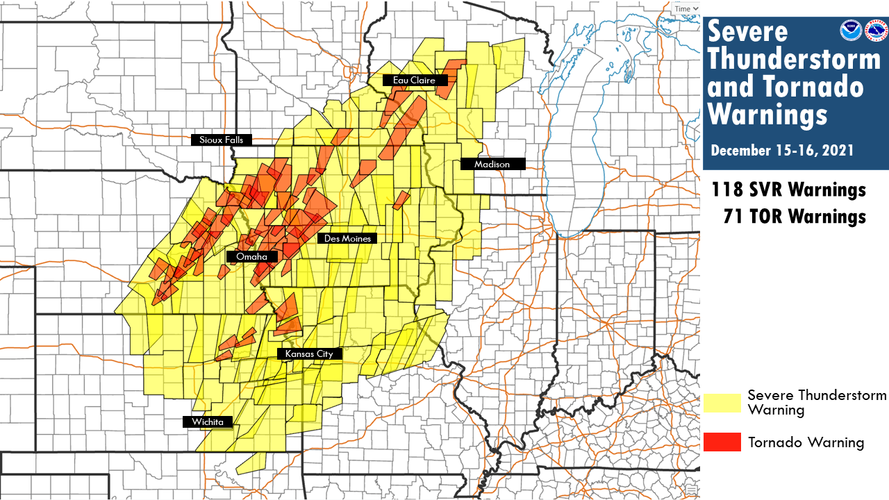
Here is a look at all the severe thunderstorm and tornado warnings that were issued during the severe weather event across the Plains and western Great Lakes. |
|
|
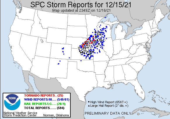
Here is a look at the preliminary severe weather reports for 12/15/2021. |
|
Temperature Records
Record High Temperatures set on Wednesday, December 15th.
| Location | New Record High | Old Record | Year(s) |
| Antigo | 53 | 43 | 1894,1913 |
| Appleton | 64 | 52 | 1920 |
| Green Bay | 64 | 49 | 1998 |
| Marshfield | 59 | 47 | 1997 |
| Merrill | 55 | 51 | 1998 |
| Oshkosh | 63 | 51 | 1984 |
| Rhinelander | 54 | 48 | 1993 |
| Wausau | 58 | 48 | 1997 |
| Wisc. Rapids | 63 | 49 | 1923 |
Record High Minimum Temperatures set on Wednesday, December 15th.
| Location | New Record High Min | Old Record | Year(s) |
| Appleton | 42 | 38 | 2014 |
| Green Bay | 39 (tied) | 39 | 2014 |
| Manitowoc | 42 | 39 | 1928, 1998 |
| Oshkosh | 45 | 40 | 2014 |
| Rhinelander | 37 (tied) | 37 | 2014 |
| Stevens Point | 37 (tied) | 37 | 1928, 2014 |
| Sturgeon Bay | 42 | 38 | 2014 |
| Wausau | 39 (tied) | 39 | 2014 |
Record High Temperatures set on Thursday, December 16th.
| Location | New Record High | Old Record | Year(s) |
| Antigo | 53 | 47 | 1913, 1952, 1993 |
| Appleton | 64 | 54 | 1984 |
| Green Bay | 65** | 54 | 1984 |
| Manitowoc | 62 | 55 | 1984 |
| Marshfield | 54 | 48 | 1984 |
| Merrill | 52 (tied) | 52 | 1913 |
| Oshkosh | 64 | 56 | 1984 |
| Rhinelander | 51 | 49 | 1913 |
| Stevens Point | 60 | 51 | 1997 |
| Sturgeon Bay | 55 | 54 | 1984 |
| Wausau | 56 | 48 | 1913, 1997 |
| Wisconsin Rapids | 62 | 54 | 1959 |
** Green Bay's high temp of 65 degrees also set an ALL TIME record high temperature for the month of December.
 |
Media use of NWS Web News Stories is encouraged! Please acknowledge the NWS as the source of any news information accessed from this site. |
|