Overview
|
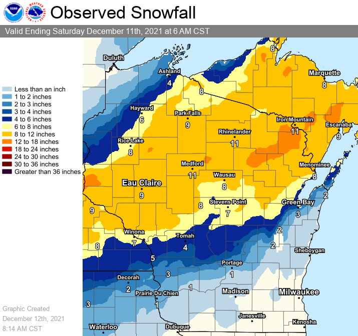
A low pressure system entered the central Plains on Friday (12/10), quickly strengthened, then turned northeast into the Great Lakes Friday night. An initial band of snow moved into northeast Wisconsin Friday afternoon, however the main band of precipitation impacted the region Friday night into Saturday morning (12/11). Gulf moisture was in place (250 percent of normal) before the storm arrived. Strong forcing, coupled with strong mid-level frontogenetical forcing, steep mid-level lapse rates and a coupled jet structure led to snow accumulations that ranged from 8 to 13 inches over northern WI to under an inch over Kewaunee and Manitowoc Counties. East-central WI saw a wintry mix Friday evening turn to rain Friday night before changing to snow Saturday morning. Hazardous road conditions were reported across the area, along with some power outages, especially across northern and northeast Wisconsin.
Please see tabs below for more information. |
To view the latest report totals, please click HERE |
Snow Reports
...DECEMBER 10/11 WINTER STORM SNOWFALL REPORTS...

LOCATION                     AMOUNT    TIME/DATE       LAT/LON

...WISCONSIN...

...BROWN COUNTY...
SUAMICO 4.4 WNW              6.8 IN    0700 AM 12/12   44.66N/88.12W
GREEN BAY (NWS)              3.8 IN    0600 AM 12/12   44.50N/88.11W
GREEN BAY 3.8 SSE            2.0 IN    0700 AM 12/12   44.47N/87.97W
WRIGHTSTOWN 0.4 ENE          1.9 IN    0700 AM 12/12   44.33N/88.17W
DENMARK WWTP                 1.4 IN    0800 AM 12/12   44.35N/87.81W

...CALUMET COUNTY...
CHILTON 0.5 E                2.0 IN    0735 AM 12/12   44.03N/88.15W
BRILLION                     1.0 IN    1040 AM 12/11   44.18N/88.07W

...DOOR COUNTY...
WASHINGTON ISLAND            6.9 IN    1040 AM 12/11   45.38N/86.90W
SISTER BAY 1 N               6.5 IN    0845 AM 12/11   45.20N/87.11W
ELLISON BAY 1 ENE            5.5 IN    0700 AM 12/12   45.26N/87.03W
FISH CREEK 1 E WWTP          5.0 IN    0515 AM 12/12   45.12N/87.23W
FORESTVILLE 4 E              2.8 IN    0700 AM 12/12   44.70N/87.40W

...FLORENCE COUNTY...
SPREAD EAGLE 1 NW            13.0 IN   0700 AM 12/12   45.89N/88.14W

...FOREST COUNTY...
ARGONNE 1.5 NW               7.9 IN    0800 AM 12/11   45.67N/88.90W

...LANGLADE COUNTY...
SUMMIT LAKE                  10.0 IN   0500 AM 12/11   45.38N/89.19W
POST LAKE                    9.0 IN    1124 AM 12/11   45.43N/89.08W
WHITE LAKE 1.4 SE            8.6 IN    0800 AM 12/12   45.15N/88.74W
ANTIGO 1 SSW                 7.5 IN    0800 AM 12/11   45.13N/89.15W

...LINCOLN COUNTY...
IRMA                         13.5 IN   0915 AM 12/11   45.34N/89.66W
TOMAHAWK 1 N                 11.5 IN   0755 AM 12/11   45.47N/89.73W
HARRISON 1 WSW               10.0 IN   0756 AM 12/11   45.47N/89.53W
MERRILL 8 W                  12.7 IN   0600 AM 12/12   45.18N/89.85W
TOMAHAWK 1.2 SSW             9.5 IN    0700 AM 12/12   45.46N/89.73W
BRADLEY 1.0 NE               9.3 IN    0700 AM 12/12   45.54N/89.73W

...MANITOWOC COUNTY...
ST. NAZIANZ 2 W              1.0 IN    0700 AM 12/12   44.00N/87.96W
MILLHOME 2 E                 0.5 IN    0700 AM 12/12   43.90N/87.91W
VALDERS 3.3 WSW              0.3 IN    0900 AM 12/11   44.04N/87.94W
TWO RIVERS 0.9 SE             T  IN     0700 AM 12/11   44.15N/87.57W

...MARATHON COUNTY...
COLBY                        12.0 IN   0125 AM 12/11   44.91N/90.30W
SHANTYTOWN 4 WNW             8.2 IN    0845 AM 12/11   44.71N/89.48W
WAUSAU 2 N                   8.0 IN    1040 AM 12/11   44.99N/89.63W
EVERGREEN 1.5 WSW            5.0 IN    0700 AM 12/12   44.84N/89.67W
WAUSAU WSAW TV               7.5 IN    1025 PM 12/11   44.95N/89.62W
WESTON 1 NE                  7.0 IN    0700 AM 12/12   44.92N/89.54W
MOON 1 E                     5.7 IN    0500 AM 12/12   44.77N/89.77W
DANCY 1 NNW                  5.7 IN    0700 AM 12/12   44.70N/89.70W

...MARINETTE COUNTY...
CRIVITZ                      12.5 IN   0312 PM 12/11   45.23N/88.02W
AMBERG 1.3 SW                12.5 IN   0800 AM 12/11   45.49N/88.01W
ATHELSTANE 1.6 E             9.0 IN    0600 AM 12/12   45.42N/88.06W
ATHELSTANE 6 SW              8.7 IN    0700 AM 12/12   45.36N/88.19W
PESHTIGO 1 S                 7.0 IN    0730 AM 12/12   45.03N/87.74W
MENOMINEE 1.6 S              5.0 IN    0730 AM 12/12   45.10N/87.62W

...OCONTO COUNTY...
STILES 1 S                   10.1 IN   0730 AM 12/12   44.84N/88.05W
MOUNTAIN 0.9 E               8.6 IN    0700 AM 12/12   45.18N/88.46W
PULASKI - WWTP               8.0 IN    0600 AM 12/12   44.68N/88.23W
UNDERHILL 4 WNW              6.3 IN    0700 AM 12/11   44.90N/88.45W

...ONEIDA COUNTY...
MONICO                       14.0 IN   0640 AM 12/11   45.58N/89.11W
RHINELANDER 2 SW             11.0 IN   0730 AM 12/12   45.60N/89.45W
MINOCQUA                     10.5 IN   0630 AM 12/12   45.89N/89.73W
HAZELHURST 2.1 SSE           10.5 IN   0700 AM 12/12   45.78N/89.70W
RHINELANDER                  9.8 IN    1030 PM 12/11   45.62N/89.41W
WILLOW                       9.7 IN    0600 AM 12/12   45.70N/89.83W
RHINELANDER 4 NE             9.1 IN    0600 AM 12/12   45.65N/89.31W
LAKE TOMAHAWK                8.5 IN    0945 AM 12/11   45.81N/89.59W

...OUTAGAMIE COUNTY...
SHIOCTON 0.6 NW              9.5 IN    0810 AM 12/12   44.44N/88.58W
NEW LONDON 4.1 N             7.3 IN    0600 AM 12/11   44.45N/88.73W
SHIOCTON                     6.8 IN    0850 AM 12/11   44.43N/88.58W
APPLETON                     5.5 IN    0500 AM 12/12   44.28N/88.44W
NEW LONDON 2 SE              5.3 IN    0630 AM 12/12   44.36N/88.72W
APPLETON 1 N                 5.2 IN    0700 AM 12/12   44.29N/88.39W

...PORTAGE COUNTY...
STEVENS POINT                7.3 IN    0730 AM 12/12   44.51N/89.59W
AMHERST 3 SE                 7.3 IN    0700 AM 12/12   44.41N/89.26W
ROSHOLT                      6.5 IN    0830 AM 12/12   44.63N/89.31W
PLOVER                       6.4 IN    0935 AM 12/11   44.45N/89.53W
RUDOLPH 1 NNE                5.6 IN    0500 AM 12/12   44.53N/89.79W
ALMOND 5 NE                  5.0 IN    0800 AM 12/11   44.31N/89.35W

...SHAWANO COUNTY...
PELLA 3 SE                   10.4 IN   0530 AM 12/11   44.74N/88.74W
SHAWANO 2 SSW                10.0 IN   0800 AM 12/12   44.76N/88.62W
BONDUEL 3.3 NW               7.5 IN    0700 AM 12/12   44.78N/88.49W
PULASKI 3.7 W                6.1 IN    0710 AM 12/12   44.67N/88.31W

...VILAS COUNTY...
ARBOR VITAE                  11.0 IN   0520 AM 12/11   45.91N/89.65W
BOULDER JUNCTION 9 ENE       10.2 IN   0715 AM 12/11   46.19N/89.46W
ST GERMAIN 0.6 NW            10.1 IN   0700 AM 12/12   45.92N/89.49W
BOULDER JUNCTION 1.4 NE      9.7 IN    0800 AM 12/12   46.13N/89.62W
EAGLE RIVER - SOUTH          9.5 IN    0659 AM 12/12   45.91N/89.24W
ARBOR VITAE-JOHNSON LAKE     9.0 IN    0601 AM 12/12   45.90N/89.73W
MANITOWISH WATERS            9.0 IN    0740 AM 12/11   46.13N/89.88W
PHELPS 4.2 N                 8.5 IN    0854 AM 12/12   46.12N/89.08W
PHELPS                       8.0 IN    0700 AM 12/12   46.07N/89.08W

...WAUPACA COUNTY...
IOLA                         10.5 IN   0950 AM 12/11   44.50N/89.11W
SCANDINAVIA                  7.8 IN    1015 AM 12/11   44.46N/89.13W
CLINTONVILLE                 6.5 IN    1030 AM 12/11   44.61N/88.75W
WAUPACA 1 E                  6.0 IN    0600 AM 12/12   44.35N/89.06W
NEW LONDON - WWTP            5.5 IN    0700 AM 12/12   44.39N/88.75W

...WAUSHARA COUNTY...
WAUTOMA 3 SE                 4.6 IN    0630 AM 12/12   44.04N/89.24W
WILD ROSE 0.5 E              4.4 IN    0700 AM 12/12   44.18N/89.24W

...WINNEBAGO COUNTY...
ZITTAU                       4.5 IN    0600 AM 12/12   44.22N/88.78W
NEENAH 1.1 ENE               2.8 IN    0700 AM 12/12   44.17N/88.45W
OSHKOSH 2.0 W                2.5 IN    0700 AM 12/12   44.02N/88.59W
OMRO 1 WSW                   1.9 IN    0700 AM 12/12   44.02N/88.78W

...WOOD COUNTY...
PORT EDWARDS 2 E             6.0 IN    0730 AM 12/12   44.34N/89.78W
RUDOLPH 2.1 W                5.5 IN    0700 AM 12/11   44.50N/89.84W


OBSERVATIONS ARE COLLECTED FROM A VARIETY OF SOURCES WITH VARYING
EQUIPMENT AND EXPOSURES. WE THANK ALL VOLUNTEER WEATHER OBSERVERS
FOR THEIR DEDICATION. NOT ALL DATA LISTED ARE CONSIDERED OFFICIAL.
Records Set
Wausau
Daily Snowfall Record for December 10 - 5.5" (Previous record was 5.1" in 2003)
Rhinelander
Daily Snowfall Record for December 10 - 8.1" (Previous record was 4.0" in 1961)
Environmental Setup:
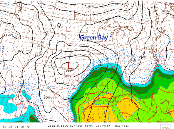 |
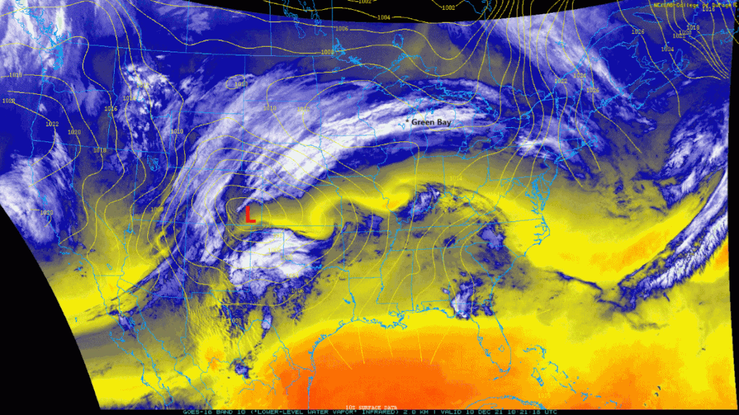
Surface Analysis with Surface Temp/Dewpoint low track Classic Colorado low. The storm was able to tap into copious moisture as it ejected northeast across the Central U.S. toward Wisconsin. Surface dew points just to the ESE of the low climbed into the 60-70F range! Surface low deepened quickly as it moved across southeast Wisconsin into Lower Michigan late Friday night. |
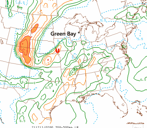 |
700-500 mb Lapse Rates This system also able to tap into some very unstable air. Some of that instability was transported northeast into Wisconsin Friday night into Saturday morning. The animation shows instability at mid-levels of the atmosphere (denoted by the U). The mid-level instability led to some isolated elevated thunderstorms that moved across the southern Fox Valley early Saturday morning. A few rumbles of thunder made it as far north as Green Bay and vicinity. |
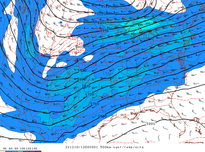 |
500 mb analysis (RAP) Note primary trough approaching from the west. Primary southern stream shortwave disturbance in southern stream approaching from southwest. |
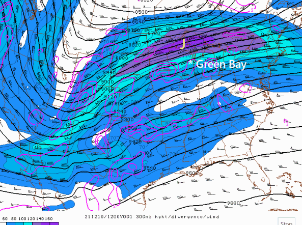 |
300 mb analysis (RAP) Note the two primary jet core (denoted by the J). The northern stream and southern stream jet energy acted in convert to produce large-scale lift and destabilization over Wisconsin. |
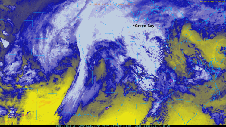 |
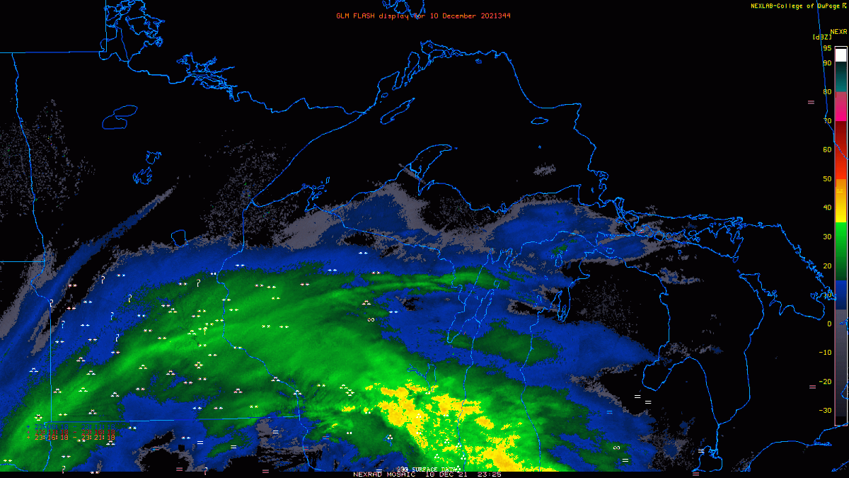
GOES 16 Water Vapor Note the location of the heavy snow (icons towards the end of the loop) and the widespread lightning associated with this winter storm. Also note the strong embedded shortwave energy (circulation) that moves across Wisconsin early Saturday morning. This feature produced isolated thunderstorms over the southern Fox Valley and a secondary burst of moderate to heavy wet snow just west of the Green Bay area producing snowfall rates of 1-2 inches per hour. |
 |
GOES 16 Water Vapor This water vapor image shows the storm developing in the southwest U.S. and moving northeast toward Great Lakes. Bands of heavy snow broke out to the northwest of the surface low track. A line of severe thunderstorms also broke out in the unseasonable warm and moist airmass across the mid-Mississippi that that produced several damaging tornadoes. |
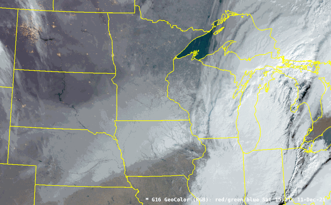 |
GOES 16 GeoColor This satellite imagery (late morning on 12/11) shows clouds quickly exiting eastern WI as the winter storm moves away from the area. You can also see the impressive snowpack stretching all the way back into Nebraska and South Dakota that the storm left in its wake! |
Radar:
 |
Animation nicely shows the initial narrower snow band extending from south-central MN across northern Wisconsin and the two surges of mixed precipitation and thunderstorms over southeast half of Wisconsin. There was a brief lull in the heavy precipitation over much of central and northeast Wisconsin before the primary upper-level jet energy moved in early Saturday morning. |
.gif) |
A more regional look at the radar shows the thunderstorm (squall line) activity over the Mid-Mississippi Valley, which spawned several deadly tornadoes. It also shows the primary snow band stretching from Iowa/Minnesota into the northwest half of Wisconsin. Also of note are the two surges of convective precipitation moving across the southeast half of Wisconsin. |
Peak Winds
...HIGHEST WIND REPORTS ON DECEMBER 11...

LOCATION                     SPEED     TIME/DATE       LAT/LON
--------------------------------------------------------------------
GILLS ROCK 1 ENE             44 MPH    1040 AM 12/11   45.29N/86.98W
STURGEON BAY AIRPORT         40 MPH    0900 AM 12/11   44.85N/87.42W
MANITOWOC AIRPORT            39 MPH    1141 AM 12/11   44.12N/87.67W
OSHKOSH AIRPORT              39 MPH    0732 AM 12/11   43.97N/88.55W
BREED 5 NE                   39 MPH    1203 PM 12/11   45.12N/88.37W
GREEN BAY AIRPORT            38 MPH    0815 AM 12/11   44.48N/88.13W
WISCONSIN RAPIDS AIRPORT     38 MPH    0642 AM 12/11   44.37N/89.83W
MARSHFIELD AIRPORT           37 MPH    0630 AM 12/11   44.63N/90.18W
MENOMINEE                    37 MPH    0836 AM 12/11   45.10N/87.59W
EPHRAIM                      36 MPH    0935 AM 12/11   45.13N/87.18W
ANTIGO AIRPORT               35 MPH    0515 AM 12/11   45.15N/89.12W
WAUSAU AIRPORT               35 MPH    0633 AM 12/11   44.93N/89.62W
WAUTOMA AIRPORT              35 MPH    1033 AM 12/11   44.03N/89.30W
WHITELAW                     34 MPH    0850 AM 12/11   44.18N/87.84W
TWO CREEKS                   34 MPH    0900 AM 12/11   44.27N/87.55W
WASHINGTON ISLAND            33 MPH    0635 AM 12/11   45.38N/86.92W
APPLETON AIRPORT             33 MPH    0845 AM 12/11   44.27N/88.52W
MARSHFIELD                   33 MPH    0400 AM 12/11   44.76N/90.10W
WRIGHTSTOWN                  32 MPH    0906 AM 12/11   44.33N/88.17W
MOSINEE AIRPORT              31 MPH    0920 AM 12/11   44.78N/89.67W
RHINELANDER                  31 MPH    0700 AM 12/11   45.65N/89.27W
ANTIGO 2 ENE                 30 MPH    0705 AM 12/11   45.16N/89.11W
PLOVER                       30 MPH    0957 AM 12/11   44.44N/89.55W
OMRO                         30 MPH    0917 AM 12/11   44.03N/88.75W
CLINTONVILLE AIRPORT         30 MPH    1215 PM 12/11   44.62N/88.73W
LAND O LAKES                 30 MPH    0535 AM 12/11   46.15N/89.22W
WAUPACA                      30 MPH    0735 AM 12/11   44.33N/89.02W
RHINELANDER AIRPORT          30 MPH    1217 PM 12/11   45.63N/89.48W
 |
Media use of NWS Web News Stories is encouraged! Please acknowledge the NWS as the source of any news information accessed from this site. |
|