Overview
|
A complex spring storm brought periods of widespread precipitation to the area over the weekend, including snow, ice, rain and thunderstorms. The most significant impacts occurred from central into northeast Wisconsin where cool surface temperatures beneath warmer air aloft resulted in a major ice storm and widespread tree damage and power outages. Ice totals from 0.25-0.6" were common. As the system moved away on Sunday, precipitation transitioned to snow before ending. The multiple rounds of rainfall resulted in rises on some rivers and streams, including minor flooding along stretches of the Wisconsin River. Please see the tabs below for additional information. |
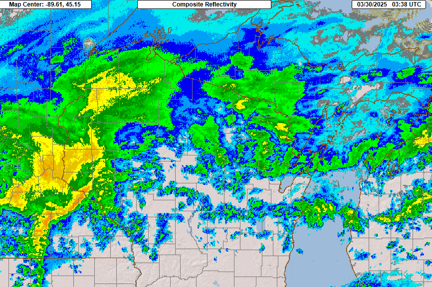 Radar animation from 10 PM March 29 to 6 AM March 31 |
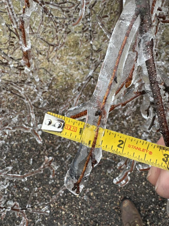
Ice Amount/Damage Reports
Here are the freezing rain and ice damage reports.
..TIME...   ...EVENT...      ...CITY LOCATION...     ...LAT.LON...
..DATE...   ....MAG....      ..COUNTY LOCATION..ST.. ...SOURCE....
            ..REMARKS..

0700 AM     Freezing Rain    Weston                  44.90N 89.57W
03/30/2025  M0.25 Inch       Marathon           WI   Public


0800 AM     Freezing Rain    Three Lakes             45.79N 89.16W
03/30/2025  M0.25 Inch       Oneida             WI   Public


1000 PM     Freezing Rain    Plover                  44.45N 89.54W
03/29/2025  M0.01 Inch       Portage            WI   CO-OP Observer

            0.04 liquid fell during the ice accumulation
            on surfaces.

0350 AM     Freezing Rain    1 SW Plover             44.44N 89.55W
03/30/2025  M0.30 Inch       Portage            WI   CO-OP Observer

            Small bushes are drooping from the ice
            weight. Roads and sidewalks are extremely
            slippery.

0350 AM     Freezing Rain    1 SW Plover             44.44N 89.55W
03/30/2025  M0.30 Inch       Portage            WI   CO-OP Observer

            Small bushes are drooping from the ice
            weight. Roads and sidewalks are extremely
            slippery.

0630 AM     Freezing Rain    2 N Wausau              44.99N 89.63W
03/30/2025  M0.20 Inch       Marathon           WI   Broadcast Media

            Ice accumulations on elevated, non-paved
            surfaces, including trees. Reported by
            WSAW-TV.

0730 AM     Freezing Rain    1 SW Plover             44.44N 89.55W
03/30/2025  M0.20 Inch       Portage            WI   Public


0756 AM     Freezing Rain    4 ESE Kellner           44.32N 89.65W
03/30/2025  E0.20 Inch       Portage            WI   Public


0801 AM     Freezing Rain    1 WSW Argonne           45.66N 88.89W
03/30/2025  M0.50 Inch       Forest             WI   CO-OP Observer


0822 AM     Freezing Rain    6 W Beecher             45.58N 88.10W
03/30/2025  M0.30 Inch       Marinette          WI   Public


0917 AM     Freezing Rain    Arbor Vitae             45.92N 89.67W
03/30/2025  M0.25 Inch       Vilas              WI   Public


0917 AM     Freezing Rain    Rosholt                 44.63N 89.30W
03/30/2025  M0.10 Inch       Portage            WI   Public


0919 AM     Freezing Rain    Weston                  44.90N 89.57W
03/30/2025  M0.25 Inch       Marathon           WI   Public


0920 AM     Freezing Rain    Mountain                45.18N 88.48W
03/30/2025  M0.50 Inch       Oconto             WI   Public


0937 AM     Freezing Rain    2 E Sunset              44.97N 89.45W
03/30/2025  M0.20 Inch       Marathon           WI   Public


1011 AM     Freezing Rain    Plover                  44.46N 89.55W
03/30/2025  E0.25 Inch       Portage            WI   Public


1030 AM     Freezing Rain    Aurora                  45.78N 88.09W
03/30/2025  M0.25 Inch       Florence           WI   Public


1030 AM     Freezing Rain    Plover                  44.45N 89.54W
03/30/2025  M0.50 Inch       Portage            WI   Public


1030 AM     Freezing Rain    Lena                    44.95N 88.05W
03/30/2025  M0.30 Inch       Oconto             WI   Public


1035 AM     Freezing Rain    Tigerton                44.73N 89.05W
03/30/2025  M0.40 Inch       Shawano            WI   Public


1043 AM     Freezing Rain    6 E Knowlton            44.69N 89.55W
03/30/2025  M0.25 Inch       Marathon           WI   Public


1044 AM     Freezing Rain    1 SW Evergreen          44.83N 89.65W
03/30/2025  E0.20 Inch       Marathon           WI   Public


1044 AM     Freezing Rain    5 W Underhill           44.89N 88.47W
03/30/2025  E0.20 Inch       Oconto             WI   Public


0200 PM     Freezing Rain    4 W Sobieski            44.71N 88.14W
03/30/2025  E0.30 Inch       Oconto             WI   Public

            with photo via social media.

0210 PM     Freezing Rain    5 W Pembine             45.63N 88.10W
03/30/2025  E0.25 Inch       Marinette          WI   Public

            with photo via social media.

0634 PM     Freezing Rain    1 NW Kempster           45.29N 89.17W
03/30/2025  M0.60 Inch       Langlade           WI   Public


0746 PM     Freezing Rain    Lena                    44.95N 88.05W
03/30/2025  M0.21 Inch       Oconto             WI   Trained Spotter


0700 AM     Freezing Rain    Weston                  44.90N 89.57W
03/31/2025  M0.25 Inch       Marathon           WI   Public


0700 AM     Freezing Rain    5 SW Weston             44.85N 89.64W
03/31/2025  M0.20 Inch       Marathon           WI   Public

            2.5" of snow on top.

0756 AM     Freezing Rain    10 ENE Wausau           45.02N 89.44W
03/31/2025  M0.20 Inch       Marathon           WI   Public

            Storm totals: 3.06" rain, 2.3" snow.

0815 AM     Freezing Rain    Aurora                  45.78N 88.09W
03/31/2025  M0.25 Inch       Florence           WI   Public


0820 AM     Snow/Ice Dmg     Ephraim                 45.15N 87.16W
03/31/2025                   Door               WI   Public

            Trees down.

0830 AM     Snow/Ice Dmg     Bonduel                 44.73N 88.44W
03/31/2025                   Shawano            WI   Public

            Medium sized birch tree limbs down.

0830 AM     Freezing Rain    Lena                    44.95N 88.05W
03/31/2025  M0.30 Inch       Oconto             WI   Public

            Large tree branches snapped- amount
            estimated.

0830 AM     Snow/Ice Dmg     Wabeno                  45.43N 88.66W
03/31/2025                   Forest             WI   Public

            Tree fell on house, took power line down.

0900 AM     Freezing Rain    4 N Iola                44.56N 89.11W
03/31/2025  M0.30 Inch       Waupaca            WI   Public


0915 AM     Snow/Ice Dmg     Tigerton                44.73N 89.05W
03/31/2025                   Shawano            WI   Public

            Power lines down.

0930 AM     Snow/Ice Dmg     2 NW Argonne            45.68N 88.91W
03/31/2025                   Forest             WI   Public

            Tree limbs down.

1056 AM     Freezing Rain    Merrill                 45.18N 89.68W
03/31/2025  M0.40 Inch       Lincoln            WI   CO-OP Observer

            Amount estimated, tree and limb damage also
            observed.

1110 AM     Freezing Rain    Wisconsin Rapids        44.40N 89.84W
03/31/2025  M0.30 Inch       Wood               WI   Public
Snow Map / Reports
Here is the 2-day snowfall map and reports, ending at 7am 3/31/2025.
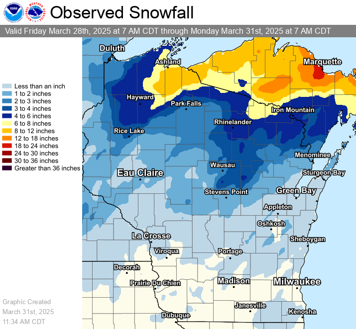
...2-DAY SNOWFALL REPORTS...

Location                     Amount    Time/Date       Lat/Lon

...Wisconsin...

...Brown County...
NWS Green Bay                0.8 in    0700 AM 03/31   44.49N/88.11W
Denmark WWTP                 0.6 in    0800 AM 03/31   44.35N/87.81W
Green Bay 3.8 SSE            0.5 in    0700 AM 03/31   44.47N/87.97W
Wrightstown 0.4 ENE          0.5 in    0700 AM 03/31   44.33N/88.17W
Howard 1.7 SSW               0.4 in    0645 AM 03/31   44.55N/88.09W

...Calumet County...
Brillion                     1.0 in    0630 AM 03/31   44.18N/88.07W
Chilton 0.5 E                1.0 in    0700 AM 03/31   44.03N/88.15W

...Door County...
Egg Harbor 2.4 ENE           2.0 in    0700 AM 03/31   45.06N/87.25W
Sister Bay 1 N               1.5 in    0700 AM 03/31   45.20N/87.11W
Egg Harbor 3.7 SSE           1.2 in    0800 AM 03/31   45.00N/87.26W
Fish Creek 1 E WWTP          1.1 in    0530 AM 03/31   45.12N/87.23W
Forestville 4 E              1.0 in    0700 AM 03/31   44.70N/87.40W
Baileys Harbor 0.3 SSW       1.0 in    0700 AM 03/31   45.06N/87.13W

...Florence County...
Spread Eagle 1 NW            7.6 in    0700 AM 03/31   45.89N/88.14W
Aurora 0.7 E                 6.8 in    0645 AM 03/31   45.78N/88.09W
Florence                     4.0 in    0700 AM 03/31   45.93N/88.26W

...Kewaunee County...
Luxemburg 5.9 S               T in     0700 AM 03/31   44.46N/87.72W

...Lincoln County...
Tomahawk 1.2 SSW             3.9 in    0700 AM 03/31   45.46N/89.73W
Merrill 8 W                  2.4 in    0600 AM 03/31   45.18N/89.85W
Merrill 7 W                  2.4 in    0600 AM 03/31   45.18N/89.85W
Merrill 0.9 E                2.0 in    0800 AM 03/31   45.18N/89.66W

...Manitowoc County...
Millhome 2 E                 0.6 in    0715 AM 03/31   43.90N/87.91W
Two Rivers 1.2 N             0.5 in    0700 AM 03/31   44.17N/87.58W
Two Rivers 1.5 ENE           0.5 in    0600 AM 03/31   44.16N/87.55W
Two Rivers 2 NW               T in     0700 AM 03/31   44.18N/87.58W

...Marathon County...
Wausau 1 ENE                 3.1 in    0530 AM 03/31   44.97N/89.61W
Wausau 1.6 NE                3.0 in    0700 AM 03/31   44.98N/89.62W
Evergreen 1.5 WSW            2.7 in    0700 AM 03/31   44.84N/89.67W
Wausau 1.6 ENE               2.6 in    0600 AM 03/31   44.97N/89.62W
Wausau WSAW TV               2.5 in    1125 PM 03/30   44.95N/89.62W
Wausau 2.4 W                 2.5 in    0800 AM 03/31   44.96N/89.69W
Wausau 5.4 SSW               2.3 in    0700 AM 03/31   44.89N/89.69W
Dancy 1 NNW                  1.6 in    0700 AM 03/31   44.70N/89.70W

...Marinette County...
Amberg 9 E                   3.7 in    0703 AM 03/31   45.48N/87.81W
Athelstane 1.6 E             3.5 in    0600 AM 03/31   45.42N/88.06W
Peshtigo 1 S                 0.7 in    0730 AM 03/31   45.03N/87.74W

...Oconto County...
Oconto Falls 1.0 SE          1.1 in    0630 AM 03/31   44.86N/88.13W

...Oneida County...
Rhinelander 5 N              4.8 in    0900 AM 03/31   45.71N/89.42W
Minocqua                     2.2 in    0630 AM 03/31   45.89N/89.73W

...Outagamie County...
New London 4.1 N             1.0 in    0600 AM 03/31   44.45N/88.73W
Appleton 3.0 ESE             0.7 in    0635 AM 03/31   44.25N/88.34W
Shiocton 0.6 NW              0.5 in    0730 AM 03/31   44.44N/88.58W

...Portage County...
Rudolph 1 NNE                2.4 in    0500 AM 03/31   44.53N/89.79W
Rosholt                      1.7 in    0733 AM 03/31   44.63N/89.31W
Plover 1.4 S                 1.4 in    0700 AM 03/31   44.44N/89.55W
Almond 5 NE                  1.3 in    0800 AM 03/31   44.31N/89.35W
Stevens Point                1.3 in    0710 AM 03/31   44.51N/89.59W
Amherst 3 SE                 1.2 in    0700 AM 03/31   44.41N/89.26W
Amherst 2.6 SSE              1.2 in    0700 AM 03/31   44.41N/89.26W

...Shawano County...
Birnamwood 5.9 ENE           3.4 in    0700 AM 03/31   44.95N/89.09W
Split Rock 1 NNW             2.4 in    0800 AM 03/31   44.72N/89.02W
Pella 3 SE                   2.0 in    0530 AM 03/31   44.74N/88.74W
Pulaski 3.7 W                0.8 in    0715 AM 03/31   44.67N/88.31W

...Vilas County...
Boulder Junction 9 ENE       7.0 in    0700 AM 03/31   46.19N/89.46W
Boulder Junction 1.4 NE      5.7 in    0700 AM 03/31   46.13N/89.62W
Manitowish Waters 0.6 S      4.2 in    0830 AM 03/31   46.12N/89.88W
Phelps 4.2 N                 4.0 in    0640 AM 03/31   46.12N/89.08W
Conover 4.8 WNW              3.5 in    0700 AM 03/31   46.09N/89.35W
Woodruff 2.5 NE              2.4 in    0700 AM 03/31   45.92N/89.66W
Arbor Vitae-Johnson Lake     1.6 in    0600 AM 03/31   45.90N/89.73W

...Waupaca County...
New London - WWTP            1.0 in    0700 AM 03/31   44.39N/88.75W
Clintonville 0.7 WNW         1.0 in    0700 AM 03/31   44.63N/88.76W
Waupaca 0.3 SSW              1.0 in    0720 AM 03/31   44.35N/89.08W
Clintonville 0.9 N           0.9 in    0600 AM 03/31   44.62N/88.75W

...Waushara County...
Wild Rose 0.5 E              1.4 in    0500 AM 03/31   44.18N/89.24W

...Winnebago County...
Neenah 1.1 ENE               1.2 in    0700 AM 03/31   44.17N/88.45W
Oshkosh                      1.0 in    0700 AM 03/31   44.03N/88.56W
Omro 1 WSW                   0.9 in    0700 AM 03/31   44.02N/88.78W
Menasha 0.3 W                0.2 in    0700 AM 03/31   44.21N/88.44W

...Wood County...
Hewitt 0.8 N                 2.0 in    0730 AM 03/31   44.64N/90.13W
Marshfield 6.5 S             2.0 in    0800 AM 03/31   44.57N/90.18W
Port Edwards 2 E             1.2 in    0730 AM 03/31   44.34N/89.78W

Observations are collected from a variety of sources with varying
equipment and exposures. We thank all volunteer weather observers
for their dedication. Not all data listed are considered official.
Records
Here are the precipitation records sent during the event:
...RECORD DAILY PRECIPITATION SET ON MARCH 29 AND 30...

MARCH 29
                    NEW            OLD
LOCATION           RECORD         RECORD         YEAR(S)
----------------------------------------------------------
MARSHFIELD          1.04           0.88           1938


MARCH 30
                    NEW            OLD
LOCATION           RECORD         RECORD         YEAR(S)
----------------------------------------------------------
RHINELANDER         1.95           0.84           1938
WAUSAU              1.14           0.65           2013
WISCONSIN RAPIDS    1.05           1.00           1982
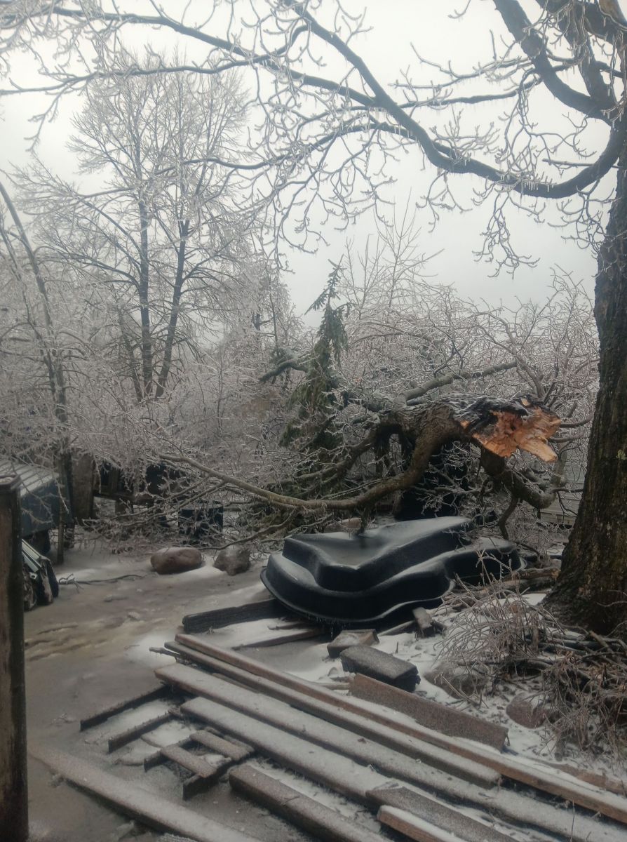
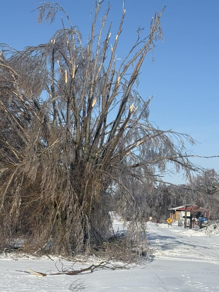
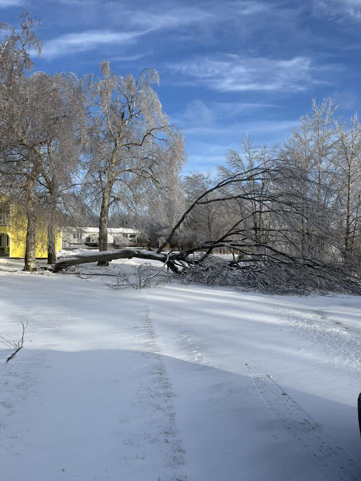
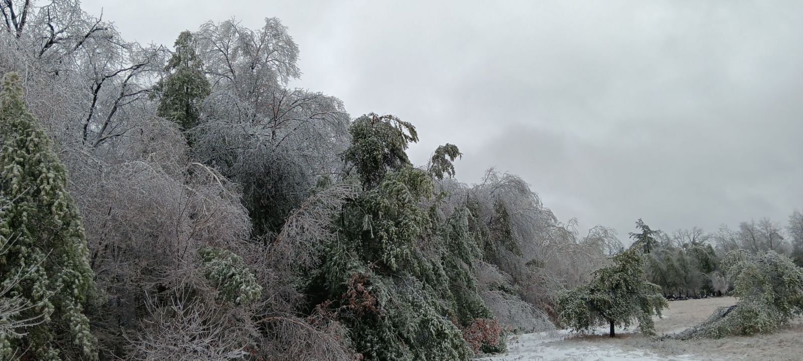
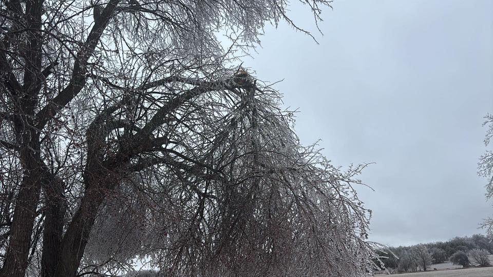
Photos & Video:
Header
 |
 |
 |
 |
| Tree damage in Argonne (Source: Ben Johnson) |
Tree limb damage in Bonduel (Source: Christine Reinke) |
Tree damage in Ephraim (Source: Sarah Anschutz) | Plover ice (Source: Chris Poeschel) |
 |
 |
 |
 |
| Crivitz Damage (Source: Anakin Roman) |
Lena ice (Source: Kevin Croley) |
Birch tree damage in Bonduel (Source: Christine Reinke) | Ice on trees & power lines in Egg Harbor (Source: Jenna Ferdon) |
%2C%20photo%20Jennifer%20Rose%20Deschane-%20permission%20granted.jpg) |
 |
 |
|
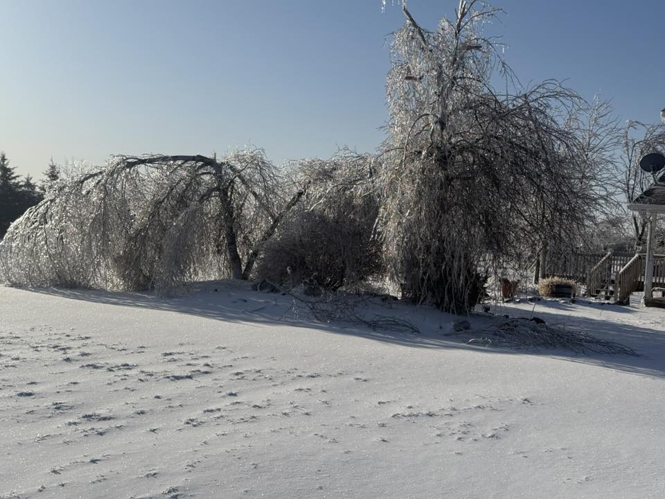
| Town of Lake (Source: Jennifer Rose Deschane) |
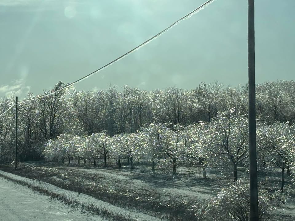
North Chase (Source: Kelly Jo Cox) |
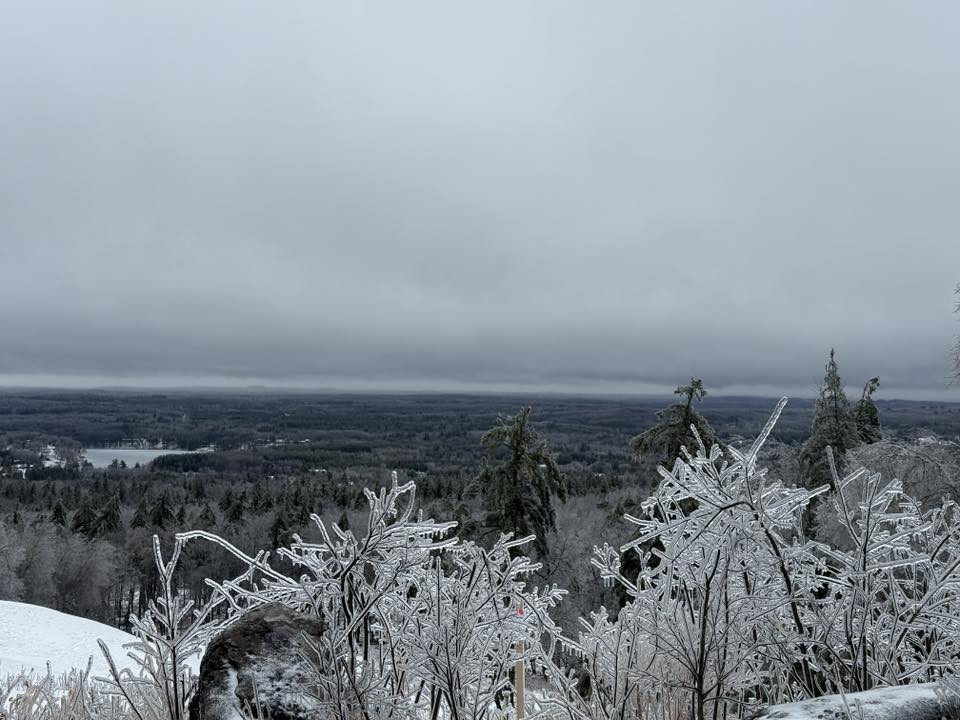
Pine Mountain Looking West (source: David Bonanti) |
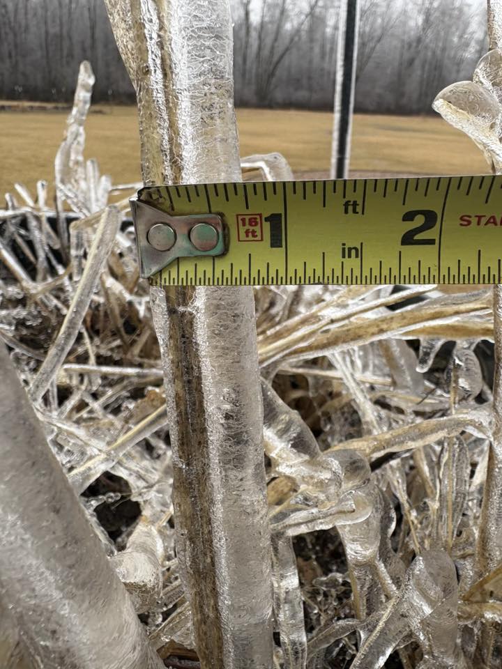
Caption (source) |
Flooding / Precip Totals
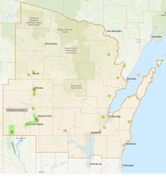 |
National Water Prediction Service (NWPS) display for the NWS Green Bay hydrologic service area around 1 pm on Monday March 31st 2025. Note the multiple river observation points that are at bankful stage (yellow dots) and the few sites along the Wisconsin River and Yellow River that are at minor flood stage (orange dots). Current river flood warnings are shaded in light green. |
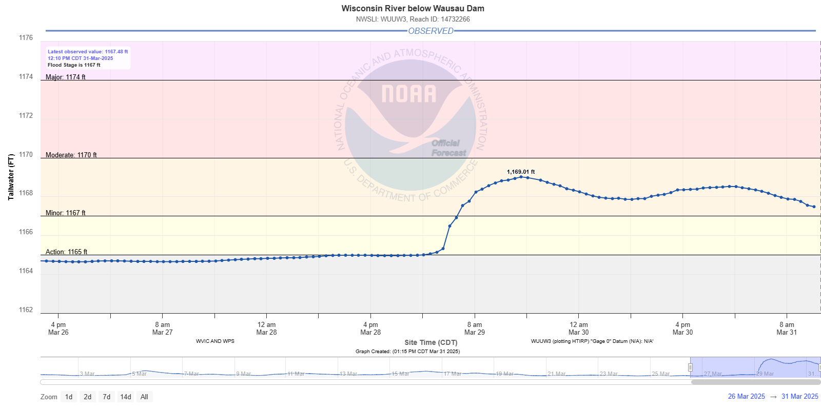
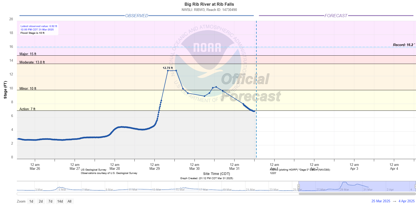
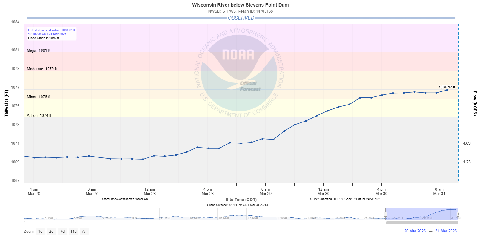
Hydrographs
 |
 |
 |
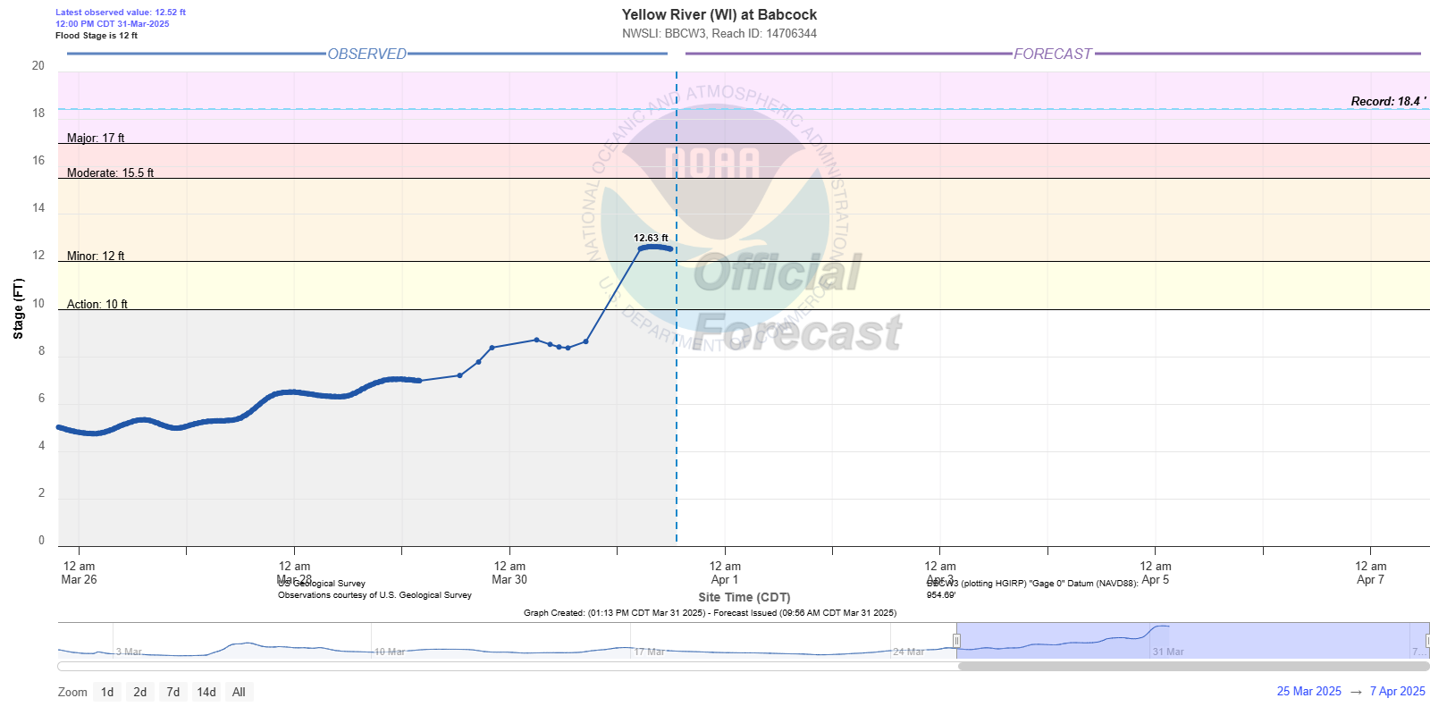 |
| Hydrograph showing rises to minor flood stage for the Wisconsin River below Wausau Dam | Hydrograph showing rises to minor flood stage for the Big Rib River at Rib Falls (western Marathon County) | Hydrograph showing rises to minor flood stage for the Wisconsin River below Stevens Point Dam | Hydrograph showing rises to minor flood stage for the Yellow River at Babcock (southwest Wood County) |
Here are the 3-day precipitation totals:
...3-DAY PRECIPITATION REPORTS...

Location                     Amount    Time/Date       Lat/Lon

...Wisconsin...

...Brown County...
Denmark                      2.53 in   1130 AM 03/31   44.39N/87.86W
Green Bay 3.8 SSE            2.22 in   0700 AM 03/31   44.47N/87.97W
De Pere                      2.07 in   1125 AM 03/31   44.44N/88.09W
Green Bay 4.4 SSW            1.84 in   0700 AM 03/31   44.46N/88.02W
Denmark WWTP                 1.74 in   0800 AM 03/31   44.35N/87.81W
De Pere                      1.65 in   1130 AM 03/31   44.37N/88.07W
Wrightstown 0.4 ENE          1.65 in   0700 AM 03/31   44.33N/88.17W
Green Bay 4.9 SSW            1.63 in   0700 AM 03/31   44.46N/88.03W
Green Bay                    1.42 in   1120 AM 03/31   44.51N/88.01W
Green Bay                    1.41 in   1115 AM 03/31   44.50N/88.01W
Denmark 1 NNE                1.25 in   1125 AM 03/31   44.35N/87.83W

...Calumet County...
Chilton 0.5 E                1.62 in   0700 AM 03/31   44.03N/88.15W
Brillion 4.9 S               1.47 in   0700 AM 03/31   44.11N/88.05W
Brillion                     1.45 in   0630 AM 03/31   44.18N/88.07W
Chilton 1 W                  0.61 in   1124 AM 03/31   44.03N/88.17W
Forest Junction              0.60 in   1126 AM 03/31   44.21N/88.21W
New Holstein 1 W             0.55 in   1125 AM 03/31   43.95N/88.10W

...Door County...
Sister Bay 1 N               3.47 in   0700 AM 03/31   45.20N/87.11W
Ellison Bay 2 N              3.04 in   0800 AM 03/31   45.28N/87.06W
Egg Harbor 2.4 ENE           2.74 in   0700 AM 03/31   45.06N/87.25W
Potawatomi State Park 3 SE   2.57 in   1120 AM 03/31   44.83N/87.40W
Baileys Harbor 0.3 SSW       2.26 in   0700 AM 03/31   45.06N/87.13W
Brussels 3 N                 2.26 in   0700 AM 03/31   44.78N/87.62W
Potawatomi State Park 4 ESE  2.07 in   1124 AM 03/31   44.83N/87.36W
Fish Creek 1 E WWTP          2.04 in   0530 AM 03/31   45.12N/87.23W
Egg Harbor 3.7 SSE           1.90 in   0800 AM 03/31   45.00N/87.26W

...Florence County...
Spread Eagle 1 NW            3.30 in   0700 AM 03/31   45.89N/88.14W
Aurora 0.7 E                 3.24 in   0645 AM 03/31   45.78N/88.09W
Florence                     2.44 in   0700 AM 03/31   45.93N/88.26W

...Kewaunee County...
Rankin 2 E                   2.00 in   1125 AM 03/31   44.60N/87.44W
Kewaunee                     1.64 in   0700 AM 03/31   44.46N/87.50W

...Lincoln County...
Merrill 8 W                  3.64 in   0600 AM 03/31   45.18N/89.85W
Tomahawk 1.2 SSW             2.83 in   0700 AM 03/31   45.46N/89.73W

...Manitowoc County...
Two Rivers 1.2 N             1.73 in   0700 AM 03/31   44.17N/87.58W
Two Rivers 2 NW              1.54 in   0700 AM 03/31   44.18N/87.58W
Two Rivers 1.5 ENE           1.50 in   0600 AM 03/31   44.16N/87.55W
Two Rivers 2 NW              1.48 in   0700 AM 03/31   44.18N/87.58W
Manitowoc 5.1 SW             1.26 in   0800 AM 03/31   44.06N/87.76W
Manitowoc                    1.25 in   1130 AM 03/31   44.09N/87.66W
Reedsville                   1.23 in   1115 AM 03/31   44.23N/87.96W
Millhome 2 E                 1.16 in   0715 AM 03/31   43.90N/87.91W
Mishicot 0.1 NNW             1.10 in   0800 AM 03/31   44.23N/87.64W

...Marathon County...
Wausau 1 ENE                 2.75 in   0530 AM 03/31   44.97N/89.61W
Wausau 1.6 NE                2.71 in   0700 AM 03/31   44.98N/89.62W
Wausau 2.4 W                 2.67 in   0800 AM 03/31   44.96N/89.69W
Wausau 1.6 ENE               2.66 in   0600 AM 03/31   44.97N/89.62W
Brokaw 1 W                   2.15 in   1120 AM 03/31   45.03N/89.69W
Evergreen 1.5 WSW            2.12 in   0700 AM 03/31   44.84N/89.67W
Dancy 1 NNW                  2.11 in   0700 AM 03/31   44.70N/89.70W

...Marinette County...
Amberg 9 E                   2.90 in   0703 AM 03/31   45.48N/87.81W
Peshtigo 1 S                 2.72 in   0730 AM 03/31   45.03N/87.74W
Wausaukee 2 NW               2.71 in   1105 AM 03/31   45.39N/87.97W
Athelstane 1.6 E             2.64 in   0600 AM 03/31   45.42N/88.06W

...Oconto County...
Oconto 5.6 WSW               2.48 in   0600 AM 03/31   44.86N/87.98W
Oconto Falls 1.0 SE          2.23 in   0630 AM 03/31   44.86N/88.13W
Mountain                     1.24 in   1038 AM 03/31   45.17N/88.44W

...Oneida County...
Rhinelander 5 N              2.07 in   0900 AM 03/31   45.71N/89.42W

...Outagamie County...
Mackville 2 S                1.58 in   0700 AM 03/31   44.31N/88.41W
Kaukauna                     1.48 in   1115 AM 03/31   44.33N/88.30W
New London 4.1 N             1.36 in   0600 AM 03/31   44.45N/88.73W
Shiocton 0.6 NW              1.15 in   0730 AM 03/31   44.44N/88.58W
Appleton                     1.14 in   1107 AM 03/31   44.29N/88.46W

...Portage County...
Amherst 1.5 N                2.54 in   0700 AM 03/31   44.47N/89.28W
Rudolph 1 NNE                1.84 in   0500 AM 03/31   44.53N/89.79W
Plover 1.4 S                 1.72 in   0700 AM 03/31   44.44N/89.55W
Plover                       1.70 in   1127 AM 03/31   44.44N/89.55W
Stevens Point                1.55 in   0710 AM 03/31   44.51N/89.59W
Amherst 3 SE                 1.41 in   0700 AM 03/31   44.41N/89.26W
Amherst 2.6 SSE              1.41 in   0700 AM 03/31   44.41N/89.26W
Rosholt                      1.33 in   0733 AM 03/31   44.63N/89.31W

...Shawano County...
Birnamwood 5.9 ENE           2.75 in   0700 AM 03/31   44.95N/89.09W
Shawano 1.6 NW               1.88 in   0700 AM 03/31   44.79N/88.62W
Keshena 2 WNW                1.73 in   1031 AM 03/31   44.85N/88.63W
Split Rock 1 NNW             1.70 in   0800 AM 03/31   44.72N/89.02W
Bonduel 3.3 NW               1.65 in   0700 AM 03/31   44.78N/88.49W
Pella 3 SE                   1.61 in   0530 AM 03/31   44.74N/88.74W

...Vilas County...
Conover 4.8 WNW              2.05 in   0700 AM 03/31   46.09N/89.35W
Manitowish Waters 0.6 S      1.74 in   0830 AM 03/31   46.12N/89.88W
Boulder Junction 1.4 NE      1.74 in   0700 AM 03/31   46.13N/89.62W
Boulder Junction 9 ENE       1.72 in   0700 AM 03/31   46.19N/89.46W
Woodruff 2.5 NE              1.62 in   0700 AM 03/31   45.92N/89.66W

...Waupaca County...
New London - WWTP            1.82 in   0700 AM 03/31   44.39N/88.75W
Clintonville 0.9 N           1.19 in   0600 AM 03/31   44.62N/88.75W
Waupaca 7.6 SW               1.09 in   0700 AM 03/31   44.27N/89.17W
Clintonville 0.7 WNW         1.01 in   0700 AM 03/31   44.63N/88.76W

...Waushara County...
Wautoma 0.4 SW               0.91 in   0700 AM 03/31   44.06N/89.30W
Wild Rose 0.5 E              0.84 in   0500 AM 03/31   44.18N/89.24W
Wild Rose 2.6 ENE            0.74 in   0700 AM 03/31   44.19N/89.20W
Wautoma 1 WSW                0.63 in   1112 AM 03/31   44.06N/89.29W
Wautoma 2 WNW                0.55 in   1125 AM 03/31   44.07N/89.31W

...Winnebago County...
Menasha 1.5 W                2.48 in   1100 AM 03/31   44.20N/88.47W
Menasha 0.3 W                1.35 in   0700 AM 03/31   44.21N/88.44W
Neenah 1.1 ENE               1.35 in   0700 AM 03/31   44.17N/88.45W
Neenah 3.0 WNW               1.24 in   0900 AM 03/31   44.19N/88.52W
Oshkosh 3.6 N                0.86 in   0652 AM 03/31   44.07N/88.55W
Omro 1 WSW                   0.82 in   0700 AM 03/31   44.02N/88.78W
Oshkosh                      0.65 in   0700 AM 03/31   44.03N/88.56W
Oshkosh 1.5 SSE              0.64 in   0700 AM 03/31   44.00N/88.54W
Oshkosh 0.8 NW               0.63 in   0700 AM 03/31   44.02N/88.57W

...Wood County...
Rudolph 2.1 W                2.39 in   0700 AM 03/31   44.50N/89.84W
Hewitt 0.8 N                 2.22 in   0730 AM 03/31   44.64N/90.13W
Marshfield 6.5 S             1.93 in   0800 AM 03/31   44.57N/90.18W

Observations are collected from a variety of sources with varying
equipment and exposures. We thank all volunteer weather observers
for their dedication. Not all data listed are considered official.
Additional Information
The Forecast
 |
 |
 |
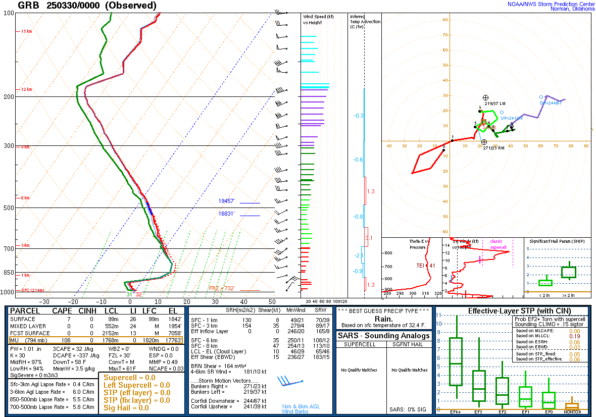 |
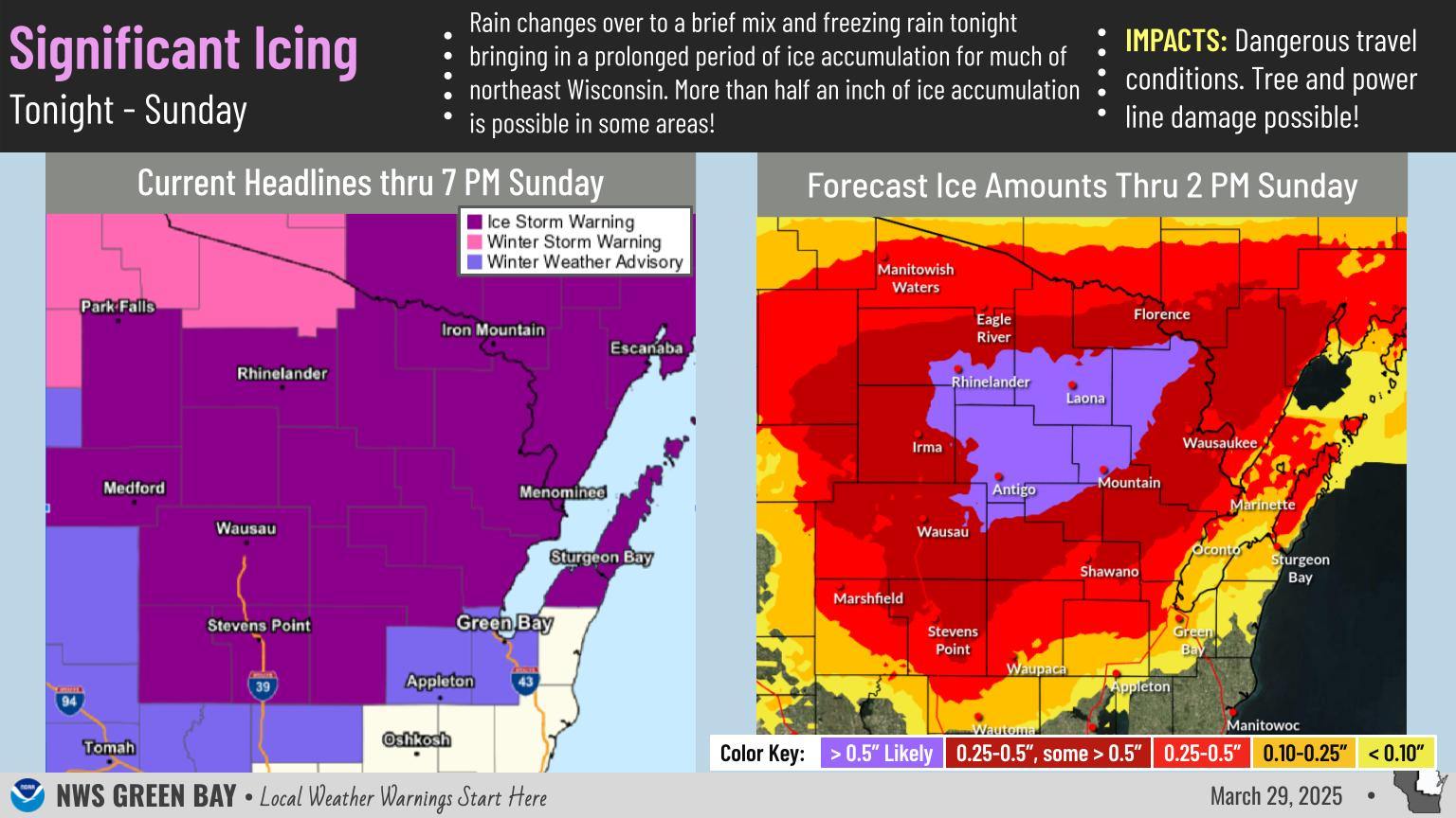
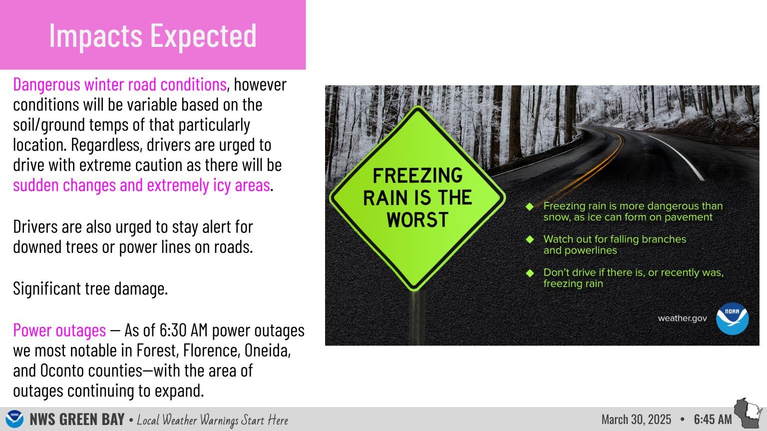
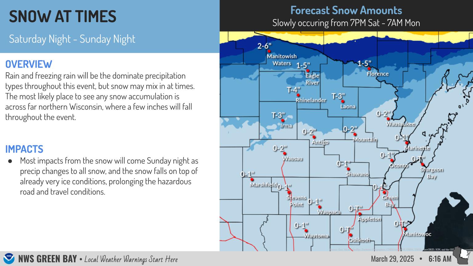
| Forecast graphic showing winter weather headlines and ice amounts | Graphic highlighting expected impacts from ice | Graphic showing forecast snow amounts | Vertical atmospheric profile from Green Bay Mar 29 showing cold air near surface with warmer air aloft |
 |
Media use of NWS Web News Stories is encouraged! Please acknowledge the NWS as the source of any news information accessed from this site. |
|

