February 8, 2025 Winter Storm
|
Event Overview
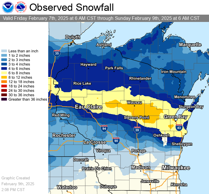
As low pressure tracked across the Ohio Valley, a frontogenetic band of snow set up across central and east central WI early February 8, producing 3-6" of snow by around sunrise. Then, during the day on February 8, another frontogenetic band, aided by a strong upper jet, developed over the same location, producing another 3-6" of snow. Storm total snow amounts of 6-11" were observed in the heaviest band. See map on the right for estimated totals. Daily snowfall records were set at Green Bay (7.0"), Wausau (9.5"), Appleton (6.2"), and Oshkosh (4.7"). This was the greatest snowfall of the season for locations in the heavier snow band.
Please see tabs below for more information. |
|
Snow Reports
...PRELIMINARY SNOWFALL REPORTS...

Observations are collected from a variety of sources with varying
equipment and exposures. We thank all volunteer weather observers
for their dedication. Not all data listed are considered official.
Location                     Amount    Time/Date       Provider

...Wisconsin...

...Brown County...
4 WSW New Franken            9.2 in    0538 PM 02/08
2 ENE Oneida                 9.0 in    0743 PM 02/08   Public
2 WNW Howard                 8.5 in    0558 PM 02/08
2 WNW Green Bay              8.5 in    0700 PM 02/08   Trained Spotter
Wrightstown                  7.6 in    0752 PM 02/08
Wrightstown 0.4 ENE          7.6 in    0700 AM 02/09   COCORAHS
1 NW Allouez                 7.5 in    0631 PM 02/08   Trained Spotter
1 NW Howard                  7.3 in    0627 PM 02/08   Public
Green Bay 3.8 SSE            7.0 in    0610 AM 02/09   COCORAHS
1 NNE Ashwaubenon            7.0 in    0929 PM 02/08   Public
1 W Bellevue                 6.5 in    0353 PM 02/08
3 SE De Pere                 6.2 in    0625 AM 02/09   Public
Green Bay                    6.2 in    0325 PM 02/08   Public
1 SSW Green Bay              6.2 in    0325 PM 02/08   Broadcast Media
Denmark WWTP                 5.8 in    0630 AM 02/09   COOP


...Calumet County...
Brillion                     10.0 in   0700 PM 02/08   Public
1 NNE High Cliff State Park  7.0 in    0624 PM 02/08   Public
Brillion                     7.0 in    0630 AM 02/09   COOP
Brillion 4.9 S               6.5 in    0700 AM 02/09   COCORAHS
Menasha 2.4 E                6.5 in    0700 AM 02/09   COCORAHS
Chilton 0.5 E                4.5 in    0702 AM 02/09   COOP

...Door County...
Sturgeon Bay                 10.0 in   0900 PM 02/08   Trained Spotter
Forestville 4 E              6.1 in    0700 AM 02/09   UCOOP
1 N Egg Harbor               5.2 in    1001 PM 02/08   NWS Employee
Sturgeon Bay                 5.0 in    0306 PM 02/08   Trained Spotter
Washington Island            4.8 in    0700 AM 02/09   COOP
Egg Harbor 2.4 ENE           4.1 in    0700 AM 02/09   COCORAHS
Sister Bay 1 N               3.4 in    0700 AM 02/09   COCORAHS

...Florence County...
Spread Eagle 1 NW            4.0 in    0700 AM 02/09   COCORAHS
2 NW Spread Eagle            4.0 in    0707 PM 02/08   Public
Aurora 0.7 E                 3.0 in    0640 AM 02/09   COCORAHS

...Forest County...
Argonne 1.5 NW               2.5 in    0722 AM 02/09   COOP

...Kewaunee County...
1 WNW Algoma                 9.5 in    0719 PM 02/08   Public
Casco 0.4 NNW                7.5 in    0814 AM 02/09   COCORAHS
Kewaunee                     2.7 in    0630 AM 02/09   COOP

...Langlade County...
White Lake 1.4 SE            7.6 in    0800 AM 02/09   COOP
4 W Antigo                   6.5 in    0700 PM 02/08   Public
Summit Lake                  6.3 in    0500 AM 02/09   COOP

...Lincoln County...
Merrill 14.1 W               7.0 in    0700 AM 02/09   COCORAHS
Bradley 1.0 NE               6.3 in    0700 AM 02/09   COOP
Merrill 8 W                  6.1 in    0600 AM 02/09   UCOOP
Merrill 7 W                  6.1 in    0600 AM 02/09   COCORAHS
Tomahawk 4.6 N               6.0 in    0700 AM 02/09   COCORAHS
1 N Merrill                  5.5 in    0255 PM 02/08   Public
Tomahawk 1.2 SSW             5.4 in    0700 AM 02/09   COCORAHS

...Manitowoc County...
1 NNE Manitowoc              8.0 in    0800 PM 02/08   Public
2 SW Manitowoc               7.8 in    0659 PM 02/08
Two Rivers 2 NW              7.5 in    0700 AM 02/09   COCORAHS
Two Rivers 1.2 N             7.5 in    0700 AM 02/09   COCORAHS
Mishicot 0.1 NNW             7.5 in    0800 AM 02/09   COCORAHS
Two Rivers 2 NW              7.1 in    0700 AM 02/09   COCORAHS
2 NW Two Rivers              7.1 in    0706 PM 02/08
2 W Manitowoc                7.0 in    0640 PM 02/08   Public
3 N Two Rivers               6.5 in    0723 PM 02/08   Public
Two Rivers 1.5 ENE           6.1 in    0700 AM 02/09   COCORAHS
Two Rivers 0.9 SE            5.5 in    0700 AM 02/09   COCORAHS
Two Rivers                   5.5 in    0600 PM 02/08   Trained Spotter
Two Rivers                   5.0 in    0415 PM 02/08   Public
Two Rivers                   5.0 in    0700 AM 02/09   COOP
Kiel                         5.0 in    0800 PM 02/08   Public
St. Nazianz 2 W              4.7 in    0700 AM 02/09   UCOOP

...Marathon County...
Weston 1 NE                  10.4 in   0700 AM 02/09   COCORAHS
Wausau 1.6 ENE               10.2 in   0600 AM 02/09   COCORAHS
Mosinee 2 W                  10.0 in   0700 AM 02/09   COCORAHS
1 NNE Athens                 10.0 in   0635 PM 02/08   Public
Wausau 5.4 SSW               9.8 in    0800 AM 02/09   COCORAHS
1 ESE Wausau                 9.7 in    0700 PM 02/08   Public
Wausau                       9.7 in    0854 PM 02/08   Broadcast Media
4 WSW Rib Mountain           9.5 in    0530 PM 02/08
Wausau WSAW TV               9.5 in    0730 PM 02/08   COOP
2 NNW Wausau                 9.1 in    0417 PM 02/08   Trained Spotter
3 NE Colby                   9.0 in    0732 PM 02/08   Public
Wausau 1 ENE                 8.9 in    0700 AM 02/09   COCORAHS
1 NNW Hatley                 8.5 in    0715 PM 02/08   Public
Evergreen 1.5 WSW            8.1 in    0700 AM 02/09   COCORAHS
6 ESE Knowlton               6.8 in    0528 PM 02/08
Stratford 1 NW               6.8 in    0618 AM 02/09   COOP
Moon 1 E                     6.5 in    0500 AM 02/09   COOP

...Marinette County...
Peshtigo 1 S                 5.0 in    0730 AM 02/09   COOP
Peshtigo                     5.0 in    0801 PM 02/08   Public
Amberg 1.3 SW                4.0 in    0700 AM 02/09   COCORAHS
Menominee 1.6 S              3.8 in    0730 AM 02/09   COOP
Crivitz                      3.2 in    0833 AM 02/09   Public
Athelstane 1.6 E             2.9 in    0600 AM 02/09   UCOOP
Amberg 9 E                   2.8 in    0712 AM 02/09   UCOOP

...Oconto County...
Sobieski                     8.0 in    0857 PM 02/08   Public
Pulaski - WWTP               6.8 in    0600 AM 02/09   COOP
Oconto 4 W                   6.0 in    0700 AM 02/09   COOP
Mountain 0.9 E               5.2 in    0700 AM 02/09   COCORAHS
2 N Stiles                   5.0 in    0622 PM 02/08   Public

...Oneida County...
Willow                       5.7 in    0600 AM 02/09   COOP
3 NNE Jeffris                5.6 in    0853 PM 02/08   Public
Rhinelander 5.5 NW           5.5 in    0600 AM 02/09   COCORAHS
2 W Minocqua                 5.5 in    0728 PM 02/08   Public
Rhinelander 4 NE             4.8 in    0600 AM 02/09   COOP
Rhinelander                  4.7 in    0830 PM 02/08   COOP
1 W Rhinelander              4.7 in    0849 PM 02/08   Broadcast Media
Rhinelander 5 N              3.7 in    0830 AM 02/09   COCORAHS
Minocqua                     3.2 in    0630 AM 02/09   COOP

...Outagamie County...
Kimberly                     8.0 in    0800 PM 02/08   Public
New London 4.1 N             7.7 in    0600 AM 02/09   COCORAHS
1 W Kaukauna                 7.3 in    0928 PM 02/08   Trained Spotter
Little Chute                 7.0 in    0622 PM 02/08   Public
Appleton 3.0 ESE             6.7 in    0740 AM 02/09   COCORAHS
Appleton                     6.2 in    0500 AM 02/09   COOP
New London 2 SE              6.2 in    0630 AM 02/09   COOP
Shiocton 0.6 NW              6.1 in    0730 AM 02/09   COOP
Greenville                   6.0 in    0654 PM 02/08
2 NNW Appleton               6.0 in    0744 PM 02/08
3 WNW Appleton               5.0 in    0702 PM 02/08   Public

...Portage County...
1 W Rosholt                  9.1 in    0730 PM 02/08   Public
Rosholt                      9.1 in    0815 AM 02/09   COOP
1 NNE Junction City          7.0 in    0629 PM 02/08   Public
Amherst 3 SE                 6.2 in    0700 AM 02/09   UCOOP
Amherst 2.6 SSE              6.2 in    0700 AM 02/09   COCORAHS
Amherst                      6.0 in    0341 PM 02/08   Public
Rudolph 1 NNE                5.9 in    0500 AM 02/09   COCORAHS
Stevens Point                5.6 in    0725 AM 02/09   COOP
1 E Plover                   5.5 in    0703 PM 02/08   Trained Spotter
1 S Plover                   5.4 in    0802 PM 02/08   CO-OP Observer
Plover 1.4 S                 5.4 in    0700 AM 02/09   COCORAHS
1 SSW Plover                 4.7 in    0316 PM 02/08   Trained Spotter
Almond 5 NE                  4.0 in    0800 AM 02/09   UCOOP

...Shawano County...
Pella 3 SE                   11.0 in   0530 AM 02/09   UCOOP
Wittenberg                   9.5 in    0714 PM 02/08   Public
1 NW Tigerton                9.0 in    0650 PM 02/08   Public
3 WNW Shawano Lake           9.0 in    0722 PM 02/08   Public
Gresham                      8.5 in    0710 PM 02/08   Public
Shawano 2 SSW                7.9 in    0800 AM 02/09   COOP
Pulaski 3.7 W                6.8 in    0645 AM 02/09   COCORAHS

...Vilas County...
Phelps 4.2 N                 3.5 in    0740 AM 02/09   COOP
Boulder Junction 1.4 NE      3.1 in    0700 AM 02/09   COCORAHS
Conover 4.8 WNW              2.8 in    0800 AM 02/09   COCORAHS
Arbor Vitae-Johnson Lake     2.7 in    0600 AM 02/09   UCOOP
Boulder Junction 9 ENE       2.6 in    0700 AM 02/09   COCORAHS
Manitowish Waters 0.6 S      2.6 in    0730 AM 02/09   COOP
Phelps                       2.5 in    0700 AM 02/09   COOP

...Waupaca County...
4 E Northland                10.5 in   0611 PM 02/08   Trained Spotter
1 NW Iola                    10.5 in   0700 PM 02/08   Public
Clintonville                 10.0 in   0600 PM 02/08   Trained Spotter
1 NW Clintonville            10.0 in   0700 PM 02/08   Trained Spotter
Manawa                       9.0 in    0700 PM 02/08   Public
Clintonville 0.9 N           8.1 in    0700 AM 02/09   COOP
Waupaca 1 E                  6.8 in    0600 AM 02/09   COOP
Manawa 3.6 SSW               6.0 in    0600 AM 02/09   COCORAHS
New London - WWTP            6.0 in    0700 AM 02/09   UCOOP

...Waushara County...
Hancock 1.5 SW               5.5 in    0700 AM 02/09   COOP
Wautoma 3 SE                 2.5 in    0630 AM 02/09   COOP
Berlin WWTP                  2.3 in    0700 AM 02/09   COOP

...Winnebago County...
Menasha 0.3 W                6.9 in    0700 AM 02/09   COCORAHS
Neenah 1.1 ENE               6.6 in    0700 AM 02/09   COCORAHS
Oshkosh                      4.7 in    0700 AM 02/09   COOP
2 WNW Oshkosh                4.5 in    0715 PM 02/08   Public
Omro 1 WSW                   2.5 in    0700 AM 02/09   COCORAHS

...Wood County...
1 NW Marshfield              6.5 in    0703 PM 02/08   Public
Marshfield 5.6 SSW           5.4 in    0700 AM 02/09   COCORAHS
Port Edwards 2 E             4.8 in    0815 AM 02/09   COCORAHS
Marshfield 6.5 S             4.3 in    0800 AM 02/09   COCORAHS
New Rome 3 WNW               3.5 in    0700 AM 02/09   COCORAHS
Pittsville - WWTP            3.5 in    0700 AM 02/09   UCOOP
Records Set
Green Bay:
Daily Snowfall Record for February 8 - 7.0" (Previous record was 5.7" in 1950)
Wausau
Daily Snowfall Record for February 8 - 9.5" (Previous record was 8.0" in 1900)
Appleton:
Daily Snowfall Record for February 8 - 6.2" (Previous record was 4.5" in 1952)
Oshkosh:
Daily Snowfall Record for February 8 - 4.7" (Previous record was 4.5" in 1928)
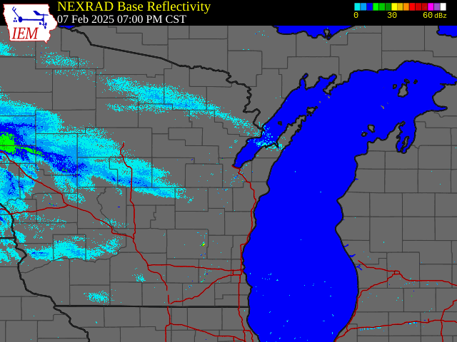
Radar:
Radar loop from 7 PM (2/7/25) - 7:45 PM (2/8/25)
 |
Media use of NWS Web News Stories is encouraged! Please acknowledge the NWS as the source of any news information accessed from this site. |
|