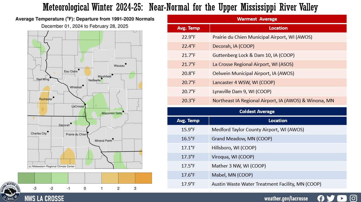
Temperatures: Highly Variable, but the Overall Seasonal Temperatures were Near-Normal
- During the meteorological winter (December 1 through February 28) of 2024-25, average temperatures ranged from 15.9°F at Medford Taylor County Airport, WI (AWOS) to 22.9°F at Prairie du Chien Municipal Airport (AWOS).
- These temperatures ranged from 2°F colder than normal to 2°F warmer than normal. While temperature for the season averaged near normal, they were highly variable.
- The warmest temperature was 62°F at Decorah, IA on January 30. The coldest temperature was -28°F at Black River Falls, WI (RAWS) on February 18.
|
 |
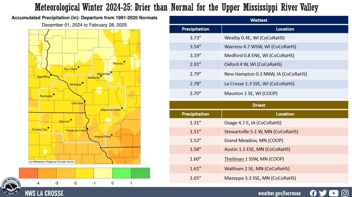
Precipitation: Below Normal
- Precipitation ranged from 1.31" near Osage, IA (CoCoRaHS) to 3.73" near Westby, WI (CoCoRaHS).
- These precipitation values ranged from near-normal to 3" drier-than-normal.
- The greatest 1-day precipitation total was 1.15" at Lynxville, Dam 9, WI (COOP) and Minnesota City Dam, MN (COOP) from 7 am on December 27 to 7 am on December 28.
|
 |
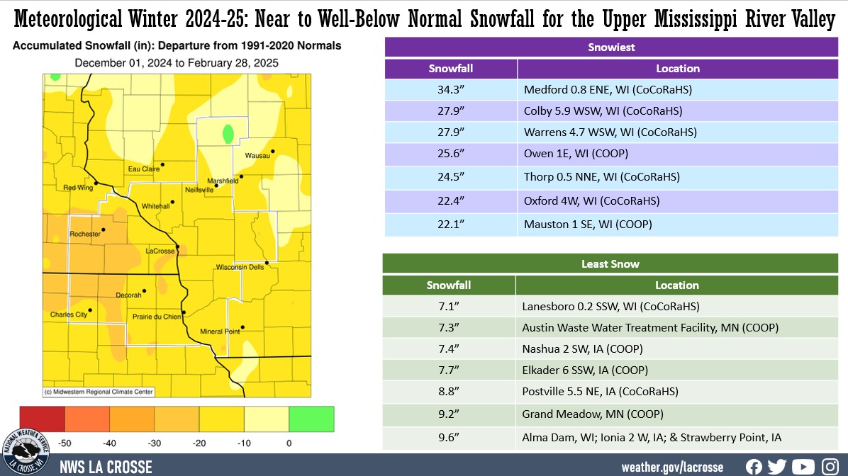
Snowfall: Near to Well-Below Normal
- Snowfall ranged from 7.1" near Lanesboro, WI (CoCoRaHS) to 34.3" near Medford, WI (CoCoRaHS).
- These snowfall values ranged from near normal to 35" below normal.
- Rochester, MN (12.5" - 22.8" below normal) had its 12th least snowiest meteorological winter.
- La Crosse, WI (15.8" - 16.6" below normal) had its 18th least snowiest meteorological winter.
- The greatest 1-day snowfall total was 9" near Owen, WI (COOP) from 7 am on February 8 to 7 am on February 9.
|
 |
Below are climate summaries for La Crosse, WI, and Rochester, MN.
La Crosse, WI
Meteorological Winter 2024-25 was Drier and Slightly Colder than Normal in La Crosse, WI
Temperatures - Slightly Colder than Normal
- From December 1 through February 28, the average temperature at La Crosse Regional Airport was 21.6°F. This was 0.9°F colder than the 1991-2020 winter normal of 22.5°F.
- The average maximum temperature was 30°F. This was 0.9°F colder than the 1991-2020 normal of 30.9°F.
- The average minimum temperature was 13.2F. This was 0.9°F colder than the 1991-2020 normal of 14.1°F.
|
 |
The table below contains the monthly temperatures and their departures from normal for the winter of 2024-25.
Winter 2024-25 Temperatures
in La Crosse WI
Average Departure
Month Temperature from Normal
----- ----------- -----------
December 26.6°F + 1.5°F
January 18.5°F - 0.4°F
February 19.6°F - 3.7°F
Winter 21.6°F - 0.9°F
- The warmest high temperature was 58°F on January 30. This was the warmest January temperature. The previous record was 57°F on January 3, 1874; January 1, 1897; and January 25, 1981.
- The coldest high temperature was -1°F on January 20.
- The warmest low temperature was 40°F on February 24.
- The coldest low temperature was -18°F on February 18.
- The daily average temperatures were above normal on 45 days (50%), below normal on 42 days (46.7%), and normal on 3 days (3.3%).
- The temperature fell to zero or below zero on 16 days. Normally, there are 21 sub-zero temperatures in a winter.
Precipitation - Drier than Normal
- La Crosse Regional Airport received 2.08" of precipitation.
- This was 1.85" drier than the 1991-2020 winter normal of 3.93".
The table below contains the monthly precipitation totals and their departures from normal for the winter of 2024-25.
Winter 2024-25 Precipitation
in La Crosse WI
Precipitation Departure
Month Total from Normal
----- ------------- -----------
December 1.36 inches -0.13 inches
January 0.03 inches -1.22 inches - driest
February 0.69 inches -0.37 inches
Winter 2.08 inches -1.85 inches
- The wettest day was on December 27 when 0.62" of precipitation fell.
Precipitation was greater than or equal to...
- 0.01 inches - 21 days
- 0.10 inches - 8 days
- 0.50 inches - 1 days
- 1.00 inch - 0 days
Precipitation fell on 45 days (50%). Measurable precipitation fell on 21 days (23.3%) and trace amounts of precipitation fell on 24 days (26.7%).
Snowfall - 18th Least
- The snow observer near La Crosse Regional Airport received 15.8" of snow.
- This was 16.6" below the 1991-2020 normal of 32.4".
- This was the 18th least during a meteorological winter.
- This was the least since the 2023-24 meteorological winter (15.6" - 17th least).
The table below contains the monthly snowfall totals and their departures from normal for the winter of 2024-25.
Winter 2024-25 Snowfall
in La Crosse WI
Snowfall Departure
Month Total from Normal
----- ------------ -----------
December 8.2 inches -2.7 inches
January 0.6 inches -11.2 inches - Least
February 7.0 inches -3.7 inches
Winter 15.8 inches -16.6 inches - 18th Least
- The snowiest day was 6.6" on December 19.
- Snow fell on 36 days (40%). Measurable snow fell on 13 days (14.4%) and a trace of snow fell on another 23 days (25.6%).
Snow Depth - Below Average
- The official snow observer near La Crosse Regional Airport had an average snow depth of 1.3".
- This was 3.1" lower than the long-term average (1893-2025) of 4.4".
- The greatest snow depth was 7" on December 20.
- There was snow on the ground on 43 days (47.8%) this winter.
- Measurable snow was on the ground on 25 days (27.8%) and trace amounts of snow on the ground on 18 days (20%).
Sky Cover
- Clear - 35 days
- Partly Cloudy - 29 days
- Cloudy - 26 days
Winds
- Highest sustained winds - 39 mph from the west northwest on February 28
- Highest wind gust - 52 mph from the west northwest on February 28
Barometric Pressure
- Highest - 30.78 inches on February 18
- Lowest - 29.41 inches on January 28
Rochester, MN
Meteorological Winter 2024-25 was Drier & Slightly Warmer than Normal in Rochester, MN
Temperatures - Slightly Warmer than Normal
- From December 1 through February 28, the average temperature at Rochester International Airport was 18.4°F. This was 0.3°F warmer than the 1991-2020 winter normal of 18.1°F.
- The average maximum temperature was 26.7°F. This was 0.9°F warmer than the 1991-2020 normal of 25.8°F.
- The average minimum temperature was 10.1°F. This was 0.3°F colder than the 1991-2020 normal of 10.4°F.
|
 |
- The table below contains the monthly temperatures and their departures from normal for the winter of 2024-25.
Winter 2024-25 Temperatures
in Rochester MN
Average Departure
Month Temperature from Normal
----- ----------- -----------
December 24.1°F + 3.3°F
January 15.0°F + 0.3°F
February 16.0°F - 2.7°F
Winter 18.4°F + 0.3°F
- The warmest high temperature was 56°F on January 30.
- The coldest high temperature was -5°F on January 20.
- The warmest low temperature was 36°F on February 24.
- The coldest low temperature was -20°F on January 21.
- The daily average temperatures were above normal on 46 days (51.1%), below normal on 43 days (47.8%), and normal on 1 day (1.1%).
- The temperature fell to zero or below on 24 days. Normally, there are 27 sub-zero temperatures in a winter.
Precipitation - Drier than Normal
- Rochester International Airport received 1.77" of precipitation.
- This was 1.52" drier than the 1991-2020 winter normal of 3.29".
The table below contains the monthly precipitation totals and their departures from normal for the winter of 2024-25.
Winter 2024-25 Precipitation
in Rochester MN
Precipitation Departure
Month Total from Normal
----- ------------- -----------
December 1.27 inches -0.01 inches
January 0.02 inches -0.97 inches - Driest
February 0.48 inches -0.80 inches
Winter 1.77 inches -1.52 inches
- The wettest day was on December 27 when 0.71" of precipitation fell.
- Precipitation fell on 43 days (47.8%). Measurable precipitation fell on 17 days (18.9%) and trace amounts of precipitation fell on 26 days (28.9%).
Snowfall - 12th Least
The snow observer near Rochester International Airport received 12.5" of snow. This was 22.8" below the 1991-2020 normal of 35.3". This was the 12th least during a meteorological winter. This was the least since last winter (6th least - 9.6").
The table below contains the monthly snowfall totals and their departures from normal for the winter of 2024-25.
Winter 2024-25 Snowfall
in Rochester MN
Snowfall Departure
Month Total from Normal
----- ------------ -----------
December 6.8 inches -5.6 inches
January 0.4 inches -11.8 inches Least
February 5.3 inches -5.4 inches
Winter 12.5 inches -22.8 inches 12th Least
The snowiest day was 5.9" on December 19.
Snow fell on 33 days (36.7%). Measurable snow fell on 13 days (14.4%) and a trace of snow fell on another 20 days (22.2%).
Snow Depth - Below Average
- The official snow observer near Rochester International Airport had an average snow depth of 0.8". This was 4.3" lower than the long-term average (1893-2025) of 5.1".
- The greatest snow depth was 6" on December 20-22.
- There was snow on the ground on 34 days (37.8%) this winter. Measurable snow was on the ground on 23 days (25.6%) and trace amounts of snow on the ground on 11 days (12.2%).
Winds
- Highest sustained winds - 46 mph from the northwest on December 4 and west northwest on February 28
- Highest wind gust - 63 mph from the north northwest on December 4 and west northwest on February 28
Sky Cover
- Clear - 32 days
- Partly Cloudy - 31 days
- Cloudy - 27 days
Barometric Pressure
- Highest - 30.74 inches on February 18
- Lowest - 29.44 inches on December 8


 Weather Story
 Weather Map
 Local Radar