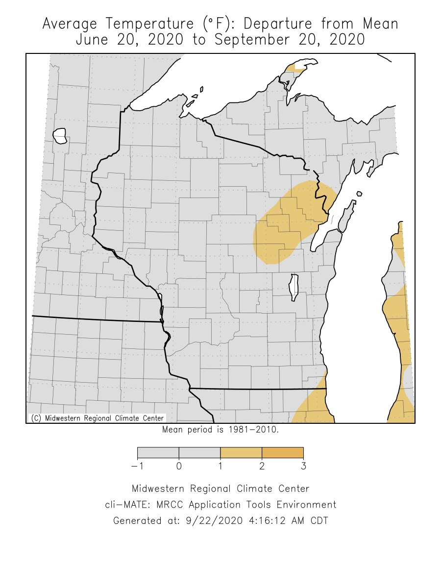
During astronomical summer (June 20 through September 21), the average temperature across the Upper Mississippi River Valley ranged from 62.6°F at Medford Taylor County Airport to 73.5°F at Mondovi, WI. These temperatures were near the long-term average.
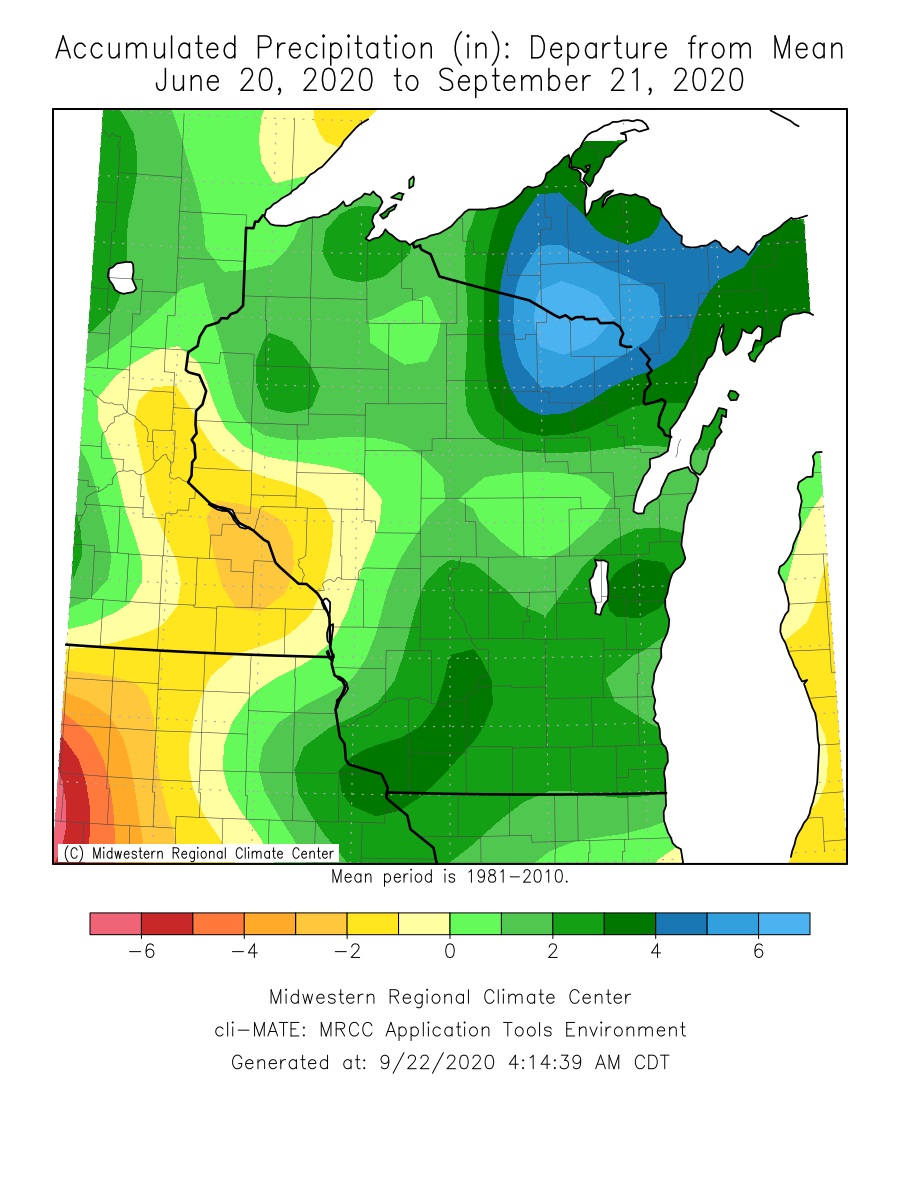
Meanwhile, rainfall was highly variable which is not that unusual for summer. The summer rainfall ranged from 7.84" in Spring Valley, MN (Fillmore County) to 20.73" near Muscoda, WI (Grant County). The largest rainfall deficits (2-4") were seen from Buffalo and Trempealeau counties in west-central Wisconsin southwest into northeast Iowa. Due to these deficits, much of this area remains abnormally (D0) dry. Meanwhile, the largest rainfall surpluses (2-6") were found from Clayton County (IA) and Grant County (WI) northeast into central Wisconsin. More details for La Crosse, WI, and Rochester, MN below.
 |
 |
| Temperature Anomalies | Rainfall Anomalies |
The astronomical summer of 2020 (June 20 through September 21) was warmer (+2.1°F) and slightly drier (-1.03") than the long-term average at La Crosse Regional Airport.
More details are listed below...
Temperatures - 26th Warmest
During astronomical summer, La Crosse Regional Airport had an average temperature of 72.2°F. This was 2.1°F warmer than the long-term average of 70.1°F. It was the coldest astronomical summer since 2017 when the average temperature was 71.8°F. During the 2 previous summers, we had our 4th warmest summer (73.9°F - tied with 1980 and 1998) in 2018 and 9th warmest summer (73.4°F - tied with 1995 and 2005).
Other temperature tidbits this summer...
The temperature climbed to or exceeded 90°F on 25 days. The long-term average is 13 days in a summer.
Rainfall - Slightly Drier-than-Average
During the astronomical summer, La Crosse Regional Airport received 10.83" of rain. This was 1.03" drier than the long-term average of 11.86". This was the driest summer since 2015 (10.29").
Other rain tidbits this summer...
The wettest calendar day occurred on August 31 when 1.98" of rain fell.
Measurable rain fell on 29 days (30.9%) and trace amounts fell on another 11 days (11.7%).
During the 2020 astronomical summer (June 20 through September 21), Rochester International Airport was 0.1°F colder than the long-term average (68.1°F) and 0.36" drier than the long-term average (11.73").
More details are listed below...
Temperatures - Very Close to the Long-term Average
During astronomical summer, Rochester International Airport had an average temperature of 68.0°F. This was 0.1°F colder than the long-term average of 68.1°F. This summer was 0.7°F cooler than last summer and the coolest summer since 2017 when the average temperature was 66.4°F.
Other temperature tidbits this summer...
The temperature climbed to or exceeded 90°F on 4 days. The long-term average is 9 days.
Rainfall - Slightly Drier than the Long-Term Average
During the astronomical summer, Rochester International Airport received 11.37" of rain. This was 0.36" drier than the long-term normal of 11.73". This summer was much drier than last summer (22.68" - a difference of 11.31"). It was the driest summer since 2017 when 9.76" of rain fell.
Other rain tidbits this summer...
The wettest day occurred on August 31 when 2.01" of rain fell.
Measurable rain fell on 28 days (29.8%) and trace amounts fell on another 13 days (13.8%).