Overview
|
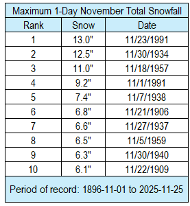
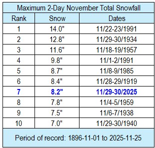
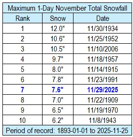
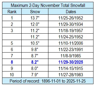
The first winter storm of the 2025-26 snow season moved northeast from southeast Colorado into southern Lower Michigan and impacted northeast Iowa, southeast Minnesota, and western Wisconsin from the evening of November 28 into the the morning of November 30. The main impact from this storm was the snowfall. Snow totals ranged from 2.5" near Medford, WI (Taylor County) to 13" in Lancaster, WI (Grant County). The official NWS snow observer near Rochester International Airport received a total of 8.5" of snow (3-day total). 7.6" of this snow fell on Novermber 29. This not only easily surpassed the previous snow record for the day (3.8" in 1988), but it was 5th largest one-day November snowfall. It was the largest one-day snowfall since March 15, 2021 (7.9"), and the largest November one-day snowfall since November 10, 2006 (10.5"). 8.2" of this snow fell on November 29-30. This was 8th largest 2-day November snowfall. This was the largest 2-day snowfall since February 23-24, 2019 (12.1") and the greatest November 2-day snowfall since November 10-11, 2006 (10.5" - 5th largest November 2-day snowfall). The official NWS snow observer near La Crosse Regional Airport received a total of 8.2" of snow (2-day total). 5.2" of this snow fell on November 29. This was the 16th largest 1-day November snowfall. It was the largest one-day snowfall since December 19, 2024 (6.6") and the largest one-day November snowfall since November 23, 1991 (5.4" - 15th largest single-day November snowfall). 8.2" of this snow fell on November 29-30. This the 7th largest 2-day November snowfall. This was the largest 2-day snowfall since April 16-17, 2023 (9.5") and the greatest 2-day November snowfall since November 22-23, 1991 (14" - largest November 2-day snowfall). |
 Observed Snowfall from 6 AM November 28 to 6 AM November 30 |
Snow
...UPDATED SNOWFALL TOTALS FROM SATURDAYS WINTER STORM...

Location                     Amount    Time/Date       Provider

...Iowa...

...Allamakee County...
5 W Dorchester               7.0 in    1041 AM 11/30   Public

...Chickasaw County...
New Hampton 0.4 SW           11.3 in   0700 AM 11/30   COCORAHS
Ionia 2W                     6.7 in    0700 AM 11/30   COOP
Fredericksburg 0.3 S         5.2 in    0800 AM 11/30   COCORAHS

...Clayton County...
Elkader 6.8 WSW              12.1 in   0630 AM 11/30   COCORAHS
Mcgregor                     9.5 in    0622 AM 11/30   Public
Guttenberg Dam 10            8.0 in    0600 AM 11/30   COOP

...Fayette County...
Fayette                      12.2 in   0700 AM 11/30   COOP
Saint Lucas                  9.0 in    0803 AM 11/30   Public

...Floyd County...
Charles City 1.2 ESE         9.1 in    0645 AM 11/30   COCORAHS
Nora Springs 2.4 SSE         9.0 in    0700 AM 11/30   COCORAHS
Nashua 2SW                   9.0 in    0700 AM 11/30   COOP

...Mitchell County...
St Ansgar                    8.0 in    0630 AM 11/30   COOP

...Winneshiek County...
7 ENE Decorah                7.6 in    0821 AM 11/30   COCORAHS
Decorah                      7.0 in    0812 AM 11/30   Public

...Minnesota...

...Dodge County...
Kasson 5.7 SE                7.7 in    0900 AM 11/30   COCORAHS
Kasson                       7.5 in    0957 AM 11/30   Public
Hayfield 0.3 SSE             7.3 in    0730 AM 11/30   COCORAHS

...Fillmore County...
Wykoff 3.1 NW                8.0 in    0700 AM 11/30   COCORAHS
Chatfield                    8.0 in    0743 AM 11/30   Public
Spring Valley                8.0 in    0700 AM 11/30   COOP
Chatfield 9.0 ESE            7.6 in    0700 AM 11/30   COCORAHS
Lanesboro 0.2 SSW            7.4 in    0600 AM 11/30   COCORAHS
3 W Wykoff                   7.3 in    0738 AM 11/30   Public
Mabel                        7.0 in    0700 AM 11/30   COOP
Spring Valley 0.9 NNW        6.4 in    0700 AM 11/30   COCORAHS

...Houston County...
1 W La Crescent              9.4 in    0702 AM 11/30   Trained Spotter
1 ENE Mound Prairie          7.4 in    0700 AM 11/30   COCORAHS
Hokah 4 NW                   7.4 in    0700 AM 11/30   COOP
Spring Grove                 7.0 in    0904 AM 11/30   Public
2 SW Mound Prairie           6.8 in    0939 AM 11/30   Public
La Crescent                  6.3 in    1007 AM 11/30   Public
Caledonia                    6.0 in    0631 AM 11/30   Public
Caledonia                    5.3 in    0730 AM 11/30   COOP

...Mower County...
Austin 2.4 W                 9.4 in    0700 AM 11/30   COCORAHS
Waltham 2.0 SE               7.0 in    0800 AM 11/30   COCORAHS

...Olmsted County...
Rochester 3.9 ESE            8.9 in    0700 AM 11/30   COCORAHS
2 NE Rochester               8.5 in    0530 AM 11/30   COCORAHS
2 NE Rochester AP            8.5 in    0600 AM 11/30   CO-OP Observer
Stewartville 4.3 E           8.0 in    0600 AM 11/30   COCORAHS
Rochester 4.7 N              7.8 in    0700 AM 11/30   COCORAHS
1 SSW Oronoco                7.6 in    0931 AM 11/30
2 WSW Rochester              7.5 in    1003 AM 11/30
3 S Predmore                 7.5 in    1024 AM 11/30   Trained Spotter
4 N Rochester                7.2 in    0947 AM 11/30   Trained Spotter
4 ESE Douglas                7.0 in    0819 AM 11/30
Byron 0.4 SSE                7.0 in    0715 AM 11/30   COCORAHS
Elgin 2SSW                   6.8 in    0700 AM 11/30   COOP
Byron 5.5 SE                 5.9 in    0730 AM 11/30   COCORAHS

...Wabasha County...
Plainview                    6.9 in    0700 AM 11/30   COCORAHS
Wabasha 6.2 WNW              6.0 in    0700 AM 11/30   COCORAHS
Mazeppa                      6.0 in    0830 AM 11/30   Public
Theilman 1 SSW               5.6 in    0730 AM 11/30   COOP
Lake City 0.7 SE             5.3 in    0800 AM 11/30   COCORAHS
Kellogg 0.1 N                5.0 in    0630 AM 11/30   COCORAHS
1 W Kellogg                  4.0 in    0800 AM 11/30   Public

...Winona County...
Utica                        8.0 in    0730 AM 11/30   Public
La Crescent 4.0 NNW          7.3 in    0700 AM 11/30   COCORAHS
Winona 6.9 ESE               7.0 in    0807 AM 11/30   COCORAHS
Winona 1.9 ESE               6.7 in    0722 AM 11/30   COCORAHS
4.2 N Rollingstone           6.5 in    0608 AM 11/30   COOP
Winona 2.0 ESE               6.4 in    0645 AM 11/30   COCORAHS

...Wisconsin...

...Adams County...
Oxford 4.0 W                 9.0 in    0700 AM 11/30   COCORAHS
Plainville                   9.0 in    0833 AM 11/30   Amateur Radio
0.6 W Friendship             8.1 in    0700 AM 11/30   COOP

...Buffalo County...
Mondovi 12.1 SSE             7.4 in    0627 AM 11/30   COCORAHS
Buffalo                      5.5 in    0818 AM 11/30   Public

...Clark County...
5 S Neillsville              5.0 in    0721 AM 11/30   Public
Thorp 10.1 S                 4.8 in    0530 AM 11/30   COCORAHS
Thorp 0.5 NNE                3.2 in    0645 AM 11/30   COCORAHS

...Crawford County...
Eastman                      8.5 in    0957 AM 11/30   Trained Spotter
1 S De Soto                  7.5 in    0805 AM 11/30   Public
3 NNE Eastman                7.0 in    0845 AM 11/30   COCORAHS
1 SE Prairie Du Chien        7.0 in    0908 AM 11/30   Public
Gays Mills 1.0 NE            6.1 in    0830 AM 11/30   COCORAHS
2.8 E Harpers Ferry          6.0 in    0800 AM 11/30   COOP
Steuben 4SE                  5.5 in    0700 AM 11/30   COOP
Soldiers Grove               5.0 in    0805 AM 11/30   Public

...Grant County...
Lancaster                    13.0 in   0756 AM 11/30   Public
Platteville                  12.0 in   0800 AM 11/30   Public
Cassville 7.8 ENE            10.8 in   0700 AM 11/30   COCORAHS
4 S Muscoda                  8.1 in    0800 AM 11/30   COCORAHS

...Jackson County...
Melrose 3.6 W                6.8 in    0700 AM 11/30   COCORAHS
Black River Falls            5.0 in    0830 AM 11/30   COOP

...Juneau County...
Union Center                 9.0 in    0556 AM 11/30   Public
New Lisbon                   8.0 in    0654 AM 11/30   Public
3 SSE Lemonweir              8.0 in    1019 AM 11/30   Emergency Mngr
1.0 E Mauston                7.0 in    0630 AM 11/30   COOP
4 SSW Plainville             6.8 in    0956 AM 11/30   Trained Spotter

...La Crosse County...
2 E La Crosse                8.5 in    0600 AM 11/30   Official NWS Obs
French Island                8.2 in    0600 AM 11/30   Official NWS Obs
Onalaska 1.9 E               7.5 in    0700 AM 11/30   COCORAHS
1 WSW La Crosse              7.1 in    1003 AM 11/30   Trained Spotter
1 WSW West Salem             6.6 in    0700 AM 11/30   Trained Spotter
West Salem 0.7 W             6.6 in    0700 AM 11/30   COCORAHS
Holmen                       6.5 in    0630 AM 11/30   Public
Coon Valley 4.5 NNW          6.0 in    0700 AM 11/30   COCORAHS
La Crosse 1.5 SSE            6.0 in    0700 AM 11/30   COCORAHS
4 NNE New Amsterdam          6.0 in    0747 AM 11/30   Public
Holmen 1.7 SSE               5.6 in    0700 AM 11/30   COCORAHS
1 NNW Onalaska               5.0 in    0940 AM 11/30

...Monroe County...
2 NNW Tomah                  6.0 in    0805 AM 11/30   Trained Spotter
Sparta                       6.0 in    0842 AM 11/30   Public
Norwalk 4.9 NNE              4.5 in    0700 AM 11/30   COCORAHS

...Richland County...
Richland Center 4.0 N        6.0 in    0800 AM 11/30   COCORAHS

...Taylor County...
0.6 SE Medford               3.0 in    0700 AM 11/30   COOP
Westboro 0.1 NW              2.6 in    0700 AM 11/30   COCORAHS
Medford 0.8 ENE              2.5 in    0700 AM 11/30   COCORAHS
Westboro                     2.5 in    0700 AM 11/30   Public

...Trempealeau County...
Ettrick 4.0 WNW              6.4 in    0800 AM 11/30   COCORAHS
3 SSE Elk Creek              5.0 in    0707 AM 11/30   Public

...Vernon County...
0.5 E Viroqua                7.1 in    0700 AM 11/30   COOP
1 SSE Cashton                6.5 in    0700 AM 11/30   COCORAHS
Hillsboro 2 SW               6.2 in    0700 AM 11/30   COOP
Stoddard 1.5 NE              5.5 in    0800 AM 11/30   COCORAHS
Stoddard 4.7 NNE             4.8 in    0700 AM 11/30   COCORAHS

Observations are collected from a variety of sources with varying
equipment and exposures. We thank all volunteer weather observers
for their dedication. Not all data listed are considered official.
More detailed snow map: https://www.weather.gov/source/crh/snowmap.html?zoom=8&lat=42.99&lon=-91.14&hr=12
Daily Snow Records
November 28-29 Cooperative Observer Records
New Records
Location Record Old Record Began
-------- ------ ---------- -------
Altura 5W, MN 1.0 inch 1.0 inch in 2018 2003
Guttenberg L&D 10, IA 2.0 inches 1.5 inches in 1971 1938
November 29 Airport and NWS Records
New Records
Location Record Old Record Began
-------- ------ ---------- -------
La Crosse WFO, WI 6.2 inches 1.2 inches in 2005 1997
Rochester, MN 7.6 inches 3.8 inches in 1988 1893
November 30 Airport and NWS Records
New Records
Location Record Old Record Began
-------- ------ ---------- -------
La Crosse WFO, WI 2.3 inches 1.9 inches in 2008 1997
Largest Single & 2-Day November Snowfalls
La Crosse, WI
 |
 |
Rochester, MN
 |
 |
Photos & Video:
 |
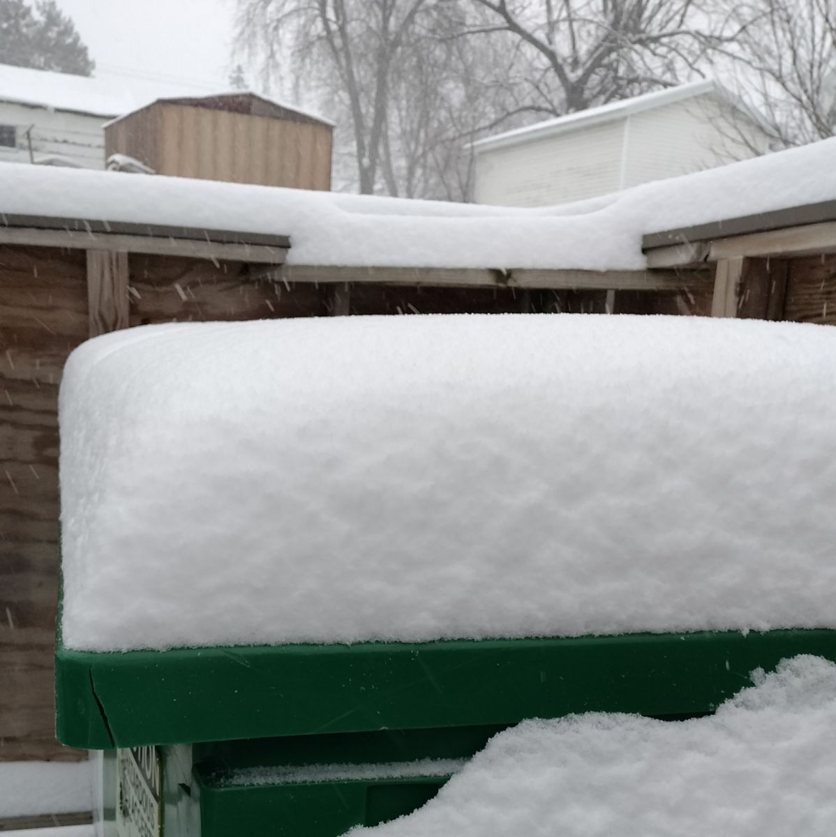 |
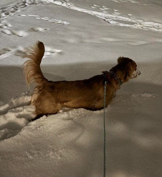 |
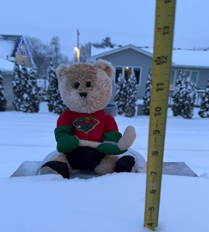 |
| Rockbridge, WI (Heather Kristoffersen) |
Lancaster, WI (Monique Smith) |
Platteville, WI (Trianna Ley) |
Austin, MN (Vicki Osier) |
 |
Media use of NWS Web News Stories is encouraged! Please acknowledge the NWS as the source of any news information accessed from this site. |
|


 Weather Story
 Weather Map
 Local Radar