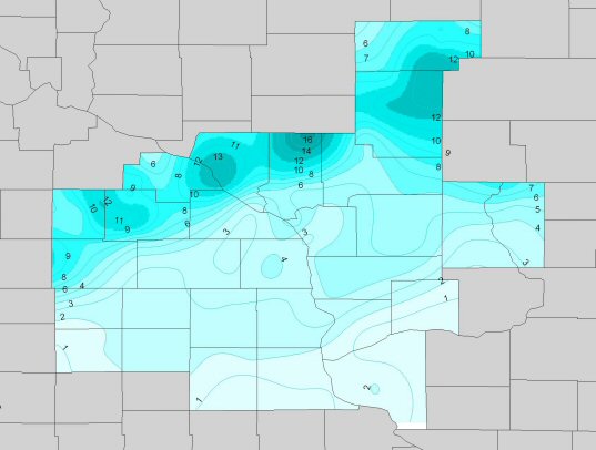
An area of low pressure moved from the Southern Plains to across northern Indiana by the evening of Friday, November 10th. Precipitation developed to the north and west of this low center, moving into southeast Minnesota and northern Iowa overnight on Thursday, and then into western Wisconsin early on the morning of the 10th. Mild air was in place across the Upper Mississippi River Valley as the low moved in, resulting in a wide variety of precipitation types for the region. Showers and even a few thunderstorms affected parts of northeast Iowa, southern Wisconsin, and northern Illinois for much of day on 10th. Sleet was mixed in at times with these showers. To the north and northwest of there, enough colder air had been entrained into the storm system to create snow.
A band of snow set up from northern Iowa...extending northeast into north central Wisconsin. The movement of the surface low was such that this band sat nearly stationary over these areas for much of Friday morning. With accumulations of 1 to 2 inches per hour common, snow quickly accumulated. Locally, a 10 to 14 inch swath of snow was centered along an axis from near Austin, MN to around Withee, WI [see map below].
This band started to move east by the early afternoon, and continued to push east into eastern Wisconsin for Friday night. This quicker movement prevented the large snow accumulations that occured to the west.

PUBLIC INFORMATION STATEMENT
NATIONAL WEATHER SERVICE LA CROSSE WI
1129 AM CST SAT NOV 11 2006
...NOVEMBER 10TH SNOWFALL TOTALS ACROSS THE AREA...


 IN NORTHEAST IOWA...

 LOCATION                  COUNTY            SNOWFALL
 --------                  ------            --------
OTRANTO                   MITCHELL             5.0
LANSING 4SE               ALLAMAKEE            3.6
DORCHESTER                ALLAMAKEE            3.6
KENDALLVILLE 3N           WINNESKIEK           3.5
ROCKFORD                  FLOYD                3.3
DECORAH 10NE              WINNESHIEK           3.0
ELMA                      HOWARD               3.0
LE ROY 2S                 HOWARD               3.0
SAINT ANSGAR              MITCHELL             3.0
DECORAH                   WINNESKIEK           2.6
CRESCO                    HOWARD               2.5
IONIA 2W                  CHICKASAW            2.2
WAUCOMA 3N                WINNESHIEK           2.1
CLERMONT                  FAYETTE              2.0
CHARLES CITY              FLOYD                2.0
WEST UNION                FAYETTE              1.5
EDGEWOOD                  CLAYTON              0.6
WADENA                    FAYETTE              0.5
OELWEIN 1E                FAYETTE              0.5
FAYETTE                   FAYETTE              0.3
ELKADER 6SSW              CLAYTON                T
IN SOUTHEAST MINNESOTA...
LOCATION                  COUNTY            SNOWFALL
--------                  ------            --------
BYRON 4N                  OLMSTED             13.0
MANTORVILLE               DODGE               12.0
ROCHESTER NW SIDE         OLMSTED             11.8
KASSON                    DODGE               11.5
ROCHESTER AP 2NE          OLMSTED             10.5
PINE ISLAND 4S            OLMSTED              9.5
ROCHESTER KTTC-TV         OLMSTED              9.5
ORONOCO 2E                OLMSTED              9.2
AUSTIN                    MOWER                9.0
MINNEISKA 2S              WINONA               9.0
ZUMBRO FALLS              WABASHA              9.0
THEILMAN 1SSW             WABASHA              8.6
WEST CONCORD              DODGE                8.5
DODGE CENTER              DODGE                8.1
HAMMOND 1S                WABASHA              8.0
ELGIN 2SSW                OLMSTED              7.9
STEWARTVILLE              OLMSTED              7.1
WABASHA                   WABASHA              7.0
OAK CENTER                WABASHA              6.5
CHATFIELD 4W              FILLMORE             5.8
GRAND MEADOW              MOWER                5.3
LYLE                      MOWER                5.0
LEWISTON                  WINONA               4.8
CALEDONIA 6S              HOUSTON              4.3
WINONA                    WINONA               4.2
GOODVIEW                  WINONA               3.8
FOUNTAIN                  FILLMORE             3.5
SPRING GROVE 4N           HOUSTON              3.3
RENO 3SW                  HOUSTON              3.2
LANESBORO                 FILLMORE             3.0
MUSCODA                   GRANT                3.0

PRESTON                   FILLMORE             2.8
HIGHLAND 2SE              FILLMORE             2.8
CALEDONIA 2S              HOUSTON              2.5
IN WESTERN WISCONSIN...
LOCATION                  COUNTY            SNOWFALL
--------                  ------            --------
OSSEO                     TREMPEALEAU         16.5
MEDFORD                   TAYLOR              13.5
BUFFALO CITY              BUFFALO             13.0
LONGWOOD                  CLARK               12.0
GAD                       TAYLOR              11.0
MEDFORD 4NW               TAYLOR              10.3
OWEN 2N                   CLARK               10.2
INDEPENDENCE 3NE          TREMPEALEAU         10.0
MEDFORD 3N                TAYLOR              10.0
MONDOVI 6S                BUFFALO             10.0
WITHEE                    CLARK                9.5
WESTBORO 4E               TAYLOR               9.0
GOODRICH 1E               TAYLOR               9.0
NEW ROME                  ADAMS                7.8
ARCADIA                   TREMPEALEAU          7.4
HUMBIRD 2NE               CLARK                6.2
MATHER 3NW                JACKSON              6.0
WARRENS 5WSW              MONROE               5.8
GALESVILLE 2E             TREMPEALEAU          5.3
TOMAH                     MONROE               5.3
WILTON 3SE                MONROE               5.2
BIG FLATS                 ADAMS                5.0
HOLLAND                   LA CROSSE            5.0
WEST SALEM                LA CROSSE            5.0
NECEDAH                   JUNEAU               5.0
HIXTON 5W                 JACKSON              5.0
TAYLOR                    JACKSON              5.0
ONTARIO                   VERNON               5.0
VIROQUA                   VERNON               5.0
ETTRICK                   TREMPEALEAU          4.8
BLAIR                     TREMPEALEAU          4.5
CHASEBURG 2S              VERNON               4.5
WESTBY 3ENE               VERNON               4.2
FRIENDSHIP                ADAMS                4.0
LA CROSSE 1SE             LA CROSSE            4.0
HILLSBORO                 VERNON               4.0
HOLMEN 2S                 LA CROSSE            3.7
LA CROSSE NWS             LA CROSSE            3.6
BLACK RIVER FALLS STP     JACKSON              3.5
BIG SPRING                ADAMS                3.5
FOUR CORNERS              MONROE               3.3
HATFIELD                  JACKSON              3.0
NEILLSVILLE 3SW           CLARK                3.0
MUSCODA                   GRANT                3.0
LA CROSSE AIRPORT         LA CROSSE            2.9
MAUSTON                   JUNEAU               2.8
LANCASTER                 GRANT                2.0
GAYS MILLS                CRAWFORD             2.0
RICHLAND CENTER           RICHLAND             1.3
CASSEVILLE 8NE            GRANT                1.1
SINSINAWA                 GRANT                1.0
CUBA CITY 2NW             GRANT                0.9
STEUBEN 4SE               CRAWFORD             0.5
PLATTEVILLE               GRANT                0.5
OBSERVATIONS ARE COLLECTED FROM A VARIETY OF SOURCES WITH
VARYING EQUIPMENT AND EXPOSURE. NOT ALL DATA LISTED IS CONSIDERED
OFFICIAL.
$$
ADAMS/BOYNE/BROOKS