Overview
|
Several rounds of severe weather impacted the area on Thursday, May 19, 2022. The first round of storms produced large hail (up to ping pong ball size) in southeast Minnesota between 12:24 - 1:54 PM. Other rounds of severe weather occurred from late afternoon through the late evening hours. These later storms led to various reports of hail, damaging winds, urban flooding in La Crosse and Winona, and a brief EF0 tornado in the Town of Wells, just southeast of Sparta, WI.
|
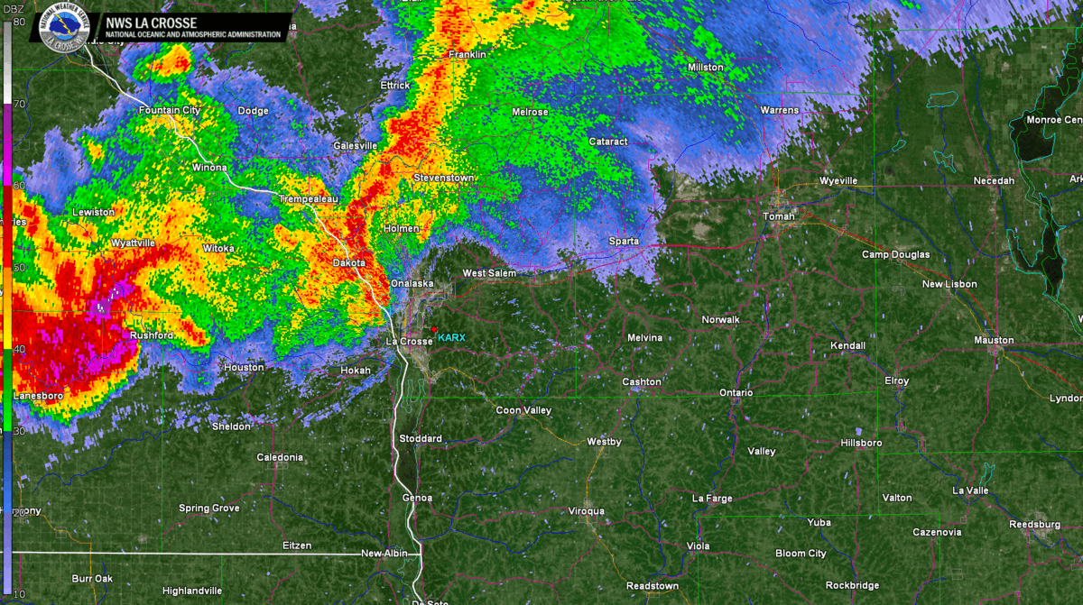 La Crosse area radar animation between 7:48-8:46 PM |
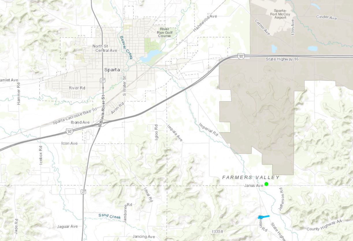
Tornado:
|
Tornado - Town of Wells (southeast of Sparta, WI)
|
||||||||||||||||
The Enhanced Fujita (EF) Scale classifies tornadoes into the following categories:
| EF0 Weak 65-85 mph |
EF1 Moderate 86-110 mph |
EF2 Significant 111-135 mph |
EF3 Severe 136-165 mph |
EF4 Extreme 166-200 mph |
EF5 Catastrophic 200+ mph |
 |
|||||
Wind & Hail:
Wind
PUBLIC INFORMATION STATEMENT
NATIONAL WEATHER SERVICE LA CROSSE WI
724 AM CDT SUN MAY 22 2022

...HIGHEST WIND REPORTS FROM MAY 19-20...

LOCATION                     SPEED     TIME/DATE

ROCHESTER INTERNATIONAL AIRP 63 MPH    0159 AM 05/20
LA CROSSE REGIONAL AIRPORT   62 MPH    0755 PM 05/19
ONALASKA                     50 MPH    0755 PM 05/19
VOLK FIELD                   48 MPH    0858 PM 05/19
OELWEIN MUNICIPAL AIRPORT    44 MPH    0215 PM 05/19
NECEDAH                      44 MPH    0948 PM 05/19
SARATOGA                     40 MPH    0415 PM 05/19
AUSTIN MUNICIPAL AIRPORT     39 MPH    0435 PM 05/19
CHARLES CITY AIRPORT         39 MPH    0635 PM 05/19
SPARTA/FORT MCCOY AIRPORT    39 MPH    0951 PM 05/19
RICEVILLE                    37 MPH    0500 PM 05/19
MAUSTON AIRPORT              37 MPH    0915 PM 05/19
PRESTON AIRPORT              37 MPH    0555 PM 05/19
LAKE CITY                    36 MPH    0215 AM 05/20
DODGE CENTER AIRPORT         36 MPH    0135 AM 05/20
VIROQUA MUNICIPAL AIRPORT    36 MPH    0915 PM 05/19
HOKAH                        35 MPH    0750 PM 05/19
PLATTEVILLE MUNICIPAL AIRPOR 35 MPH    0435 PM 05/19
BURNS                        34 MPH    0818 PM 05/19
DECORAH MUNICIPAL AIRPORT    33 MPH    0555 PM 05/19
LANCASTER                    33 MPH    0641 PM 05/19
BOSCOBEL AIRPORT             32 MPH    0818 PM 05/19
ROCHESTER                    31 MPH    0515 PM 05/19
BLACK RIVER FALLS AREA AIRPO 30 MPH    0755 PM 05/19
2 NE DOUGHERTY               29 MPH    0450 PM 05/19
PLATTEVILLE                  29 MPH    0120 AM 05/20
1 ENE JACKSON JUNCTION       28 MPH    0620 PM 05/19
MAYO HELIPAD                 28 MPH    0419 PM 05/20
MEDFORD AIRPORT              28 MPH    0835 PM 05/19
LANCASTER                    28 MPH    0600 PM 05/19
GILMAN                       27 MPH    0750 PM 05/19
TREMPEALEAU                  27 MPH    1006 PM 05/19
ROCHESTER                    26 MPH    0210 AM 05/20
NEW LISBON                   26 MPH    0915 PM 05/19
PRAIRIE DU CHIEN  AIRPORT    26 MPH    0615 PM 05/19
MONONA                       26 MPH    1029 PM 05/19

OBSERVATIONS ARE COLLECTED FROM A VARIETY OF SOURCES WITH VARYING
EQUIPMENT AND EXPOSURES. WE THANK ALL VOLUNTEER WEATHER OBSERVERS
FOR THEIR DEDICATION. NOT ALL DATA LISTED ARE CONSIDERED OFFICIAL.
Hail
...HAIL REPORTS...

Location                     Size      Time/Date       Lat/Lon

...Minnesota...

...Dodge County...
1 E Kasson                   0.70 in   0115 PM 05/19   44.03N/92.74W
1 WNW Hayfield               0.70 in   0548 PM 05/19   43.89N/92.86W
Mantorville                  0.50 in   0622 PM 05/19   44.07N/92.75W
5 S Claremont                0.25 in   0634 PM 05/19   43.98N/92.98W

...Fillmore County...
Fountain                     0.70 in   0740 PM 05/19   43.74N/92.13W
2 E Whalan                   0.50 in   0755 PM 05/19   43.73N/91.90W
Bratsberg                    0.50 in   0800 PM 05/19   43.74N/91.77W

...Houston County...
1 SSW Hokah                  1.25 in   0835 PM 05/19   43.75N/91.36W

...Mower County...
3 WNW Lyle                   1.50 in   1224 PM 05/19   43.52N/92.99W
2 S Adams                    1.50 in   1248 PM 05/19   43.54N/92.71W
Lyle                         1.25 in   1230 PM 05/19   43.51N/92.94W
3 N Lyle                     0.75 in   1229 PM 05/19   43.54N/92.95W
1 NE Mapleview               0.25 in   1240 PM 05/19   43.70N/92.96W

...Olmsted County...
5 S Rochester                1.50 in   0137 PM 05/19   43.94N/92.48W
3 ESE Rochester              1.50 in   0154 PM 05/19   44.00N/92.43W
3 S Rochester                1.25 in   0137 PM 05/19   43.97N/92.48W
1 WSW Rochester              1.00 in   0135 PM 05/19   44.01N/92.50W
2 SW Rochester               1.00 in   0138 PM 05/19   43.99N/92.50W
3 SW Chester                 1.00 in   0144 PM 05/19   43.98N/92.40W
6 NNW Genoa                  1.00 in   0406 PM 05/19   44.19N/92.66W
5 NNW Genoa                  0.88 in   0412 PM 05/19   44.19N/92.65W
4 S Rochester                0.88 in   0745 PM 05/19   43.95N/92.47W
1 NNW Rochester              0.75 in   0136 PM 05/19   44.03N/92.49W
1 E Rochester                0.75 in   0143 PM 05/19   44.02N/92.46W
Byron                        0.70 in   0129 PM 05/19   44.03N/92.65W
3 NE Byron                   0.70 in   0533 PM 05/19   44.07N/92.61W
1 WNW Rochester              0.50 in   0134 PM 05/19   44.02N/92.49W
2 SE Douglas                 0.50 in   0534 PM 05/19   44.08N/92.54W
3 SE Douglas                 0.50 in   0537 PM 05/19   44.07N/92.54W
2 NNW Rochester              0.25 in   0142 PM 05/19   44.04N/92.50W
2 SSE Douglas                0.25 in   0537 PM 05/19   44.08N/92.55W
Rochester                    0.25 in   0540 PM 05/19   44.02N/92.48W
3 SE Rochester               0.00 in   0139 PM 05/19   43.98N/92.44W

...Wabasha County...
5 W Lake City                0.75 in   0604 PM 05/19   44.44N/92.37W
4 NE Oronoco                 0.25 in   0419 PM 05/19   44.21N/92.48W

...Winona County...
New Hartford                 1.00 in   0845 PM 05/19   43.88N/91.48W
Winona                       0.70 in   0835 PM 05/19   44.05N/91.66W
Dakota                       0.70 in   0848 PM 05/19   43.91N/91.36W
1 S Goodview                 0.50 in   0834 PM 05/19   44.05N/91.71W
3 SE Ridgeway                0.50 in   0835 PM 05/19   43.89N/91.53W
1 SE Winona                  0.50 in   0838 PM 05/19   44.03N/91.64W
1 ESE Winona                 0.50 in   0839 PM 05/19   44.04N/91.64W
Ridgeway                     0.25 in   0838 PM 05/19   43.92N/91.57W

...Wisconsin...

...Adams County...
New Rome                     0.25 in   0130 AM 05/20   44.24N/89.88W

...Juneau County...
3 NE Union Center            0.75 in   1115 PM 05/19   43.72N/90.21W
1 SE Elroy                   0.50 in   0934 PM 05/19   43.73N/90.26W

...La Crosse County...
Holmen                       1.50 in   1016 PM 05/19   43.96N/91.26W
2 W Saint Joseph             1.25 in   0840 PM 05/19   43.78N/91.07W
2 E La Crosse                1.00 in   0820 PM 05/19   43.82N/91.19W
2 SSE La Crosse              1.00 in   0830 PM 05/19   43.79N/91.22W
1 SSW La Crosse              1.00 in   0837 PM 05/19   43.81N/91.25W
1 W West Salem               1.00 in   0938 PM 05/19   43.90N/91.11W
1 SE La Crosse               0.88 in   0820 PM 05/19   43.81N/91.22W
5 SSW Barre Mills            0.88 in   0855 PM 05/19   43.77N/91.16W
6 SSE La Crosse              0.75 in   0832 PM 05/19   43.75N/91.20W
4 ENE Holmen                 0.75 in   0926 PM 05/19   43.98N/91.19W
2 NNE Bangor                 0.75 in   0950 PM 05/19   43.91N/90.98W
1 SSW La Crosse              0.50 in   0821 PM 05/19   43.81N/91.24W
4 SSE La Crosse              0.50 in   0847 PM 05/19   43.77N/91.21W
2 NNW Onalaska               0.50 in   0900 PM 05/19   43.91N/91.23W
1 NNW Onalaska               0.50 in   0902 PM 05/19   43.90N/91.23W
3 E Onalaska                 0.50 in   0909 PM 05/19   43.89N/91.17W
1 SSE Holmen                 0.50 in   0925 PM 05/19   43.94N/91.25W
2 NNE Bangor                 0.50 in   0948 PM 05/19   43.91N/90.98W
1 SSE Onalaska               0.50 in   0852 AM 05/20   43.88N/91.21W
3 S La Crosse                0.25 in   0827 PM 05/19   43.79N/91.24W
2 SSE Holmen                 0.25 in   0727 AM 05/20   43.93N/91.24W
1 WNW French Island          0.25 in   0845 AM 05/20   43.87N/91.27W

...Monroe County...
Oakdale                      0.75 in   0903 PM 05/19   43.97N/90.38W
Cashton                      0.25 in   0915 PM 05/19   43.75N/90.78W

...Vernon County...
Westby                       1.25 in   0915 PM 05/19   43.66N/90.86W
1 N Hillsboro                0.50 in   0932 PM 05/19   43.66N/90.34W
1 WSW Hillsboro              0.25 in   1120 PM 05/19   43.65N/90.35W

Observations are collected from a variety of sources with varying
equipment and exposures. We thank all volunteer weather observers
for their dedication. Not all data listed are considered official.

$$
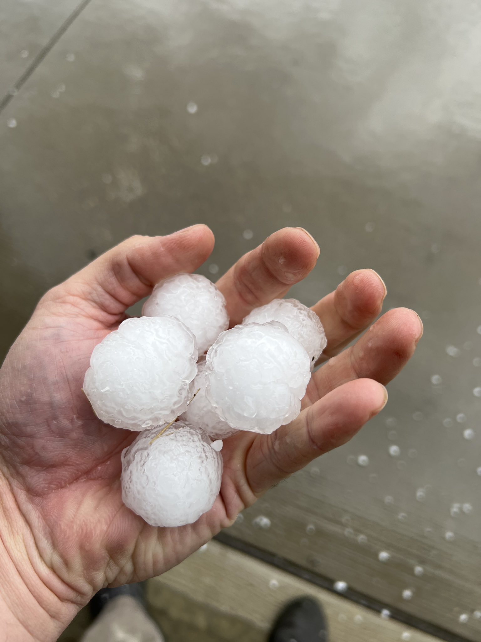
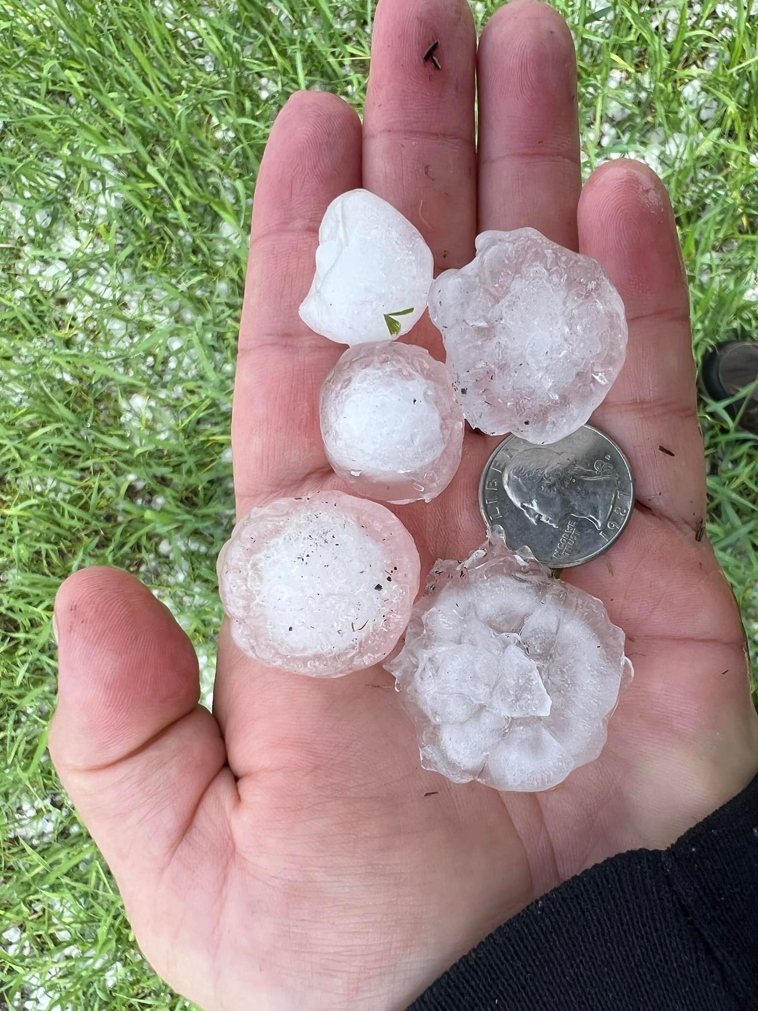
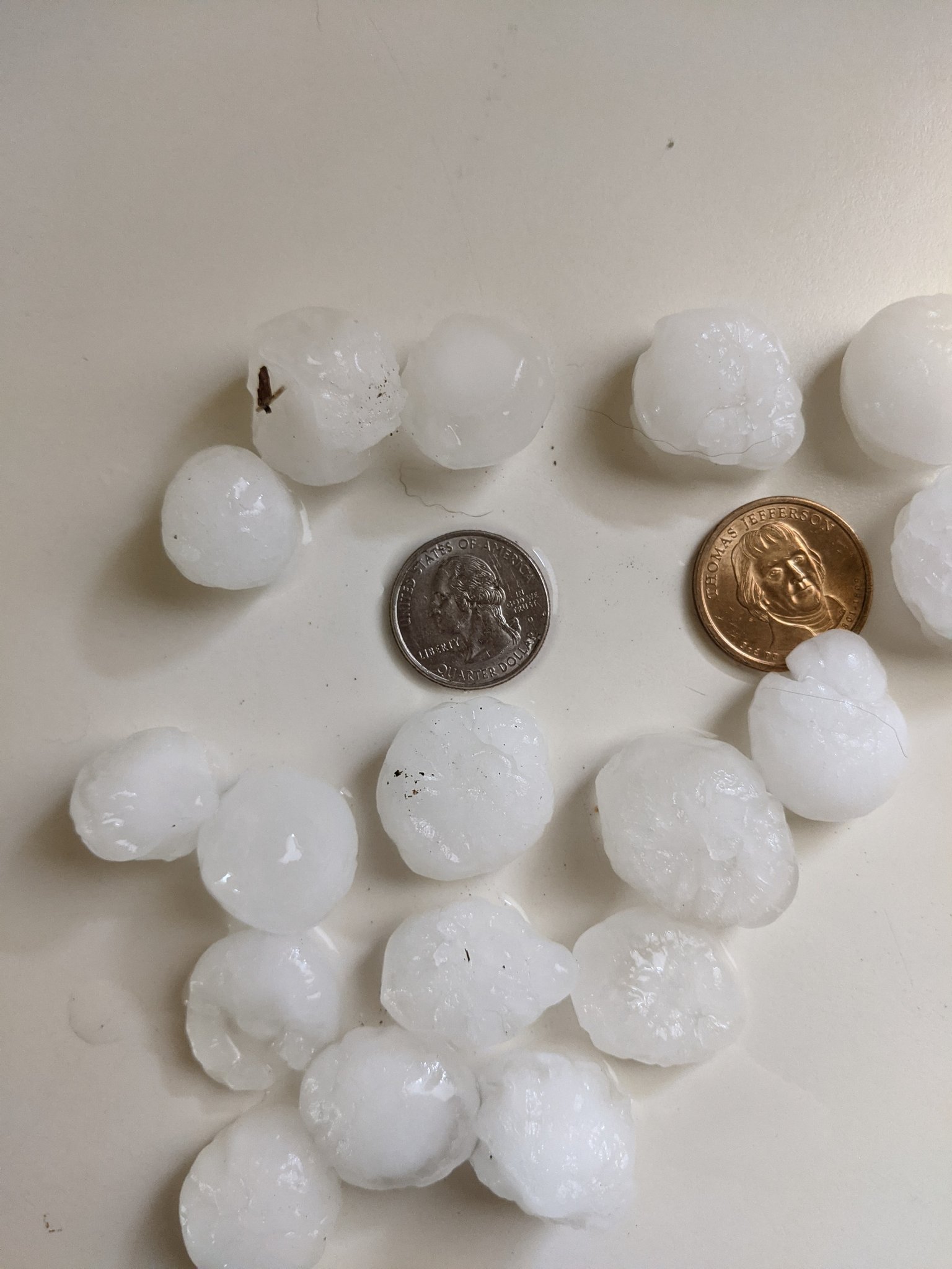
Photos:
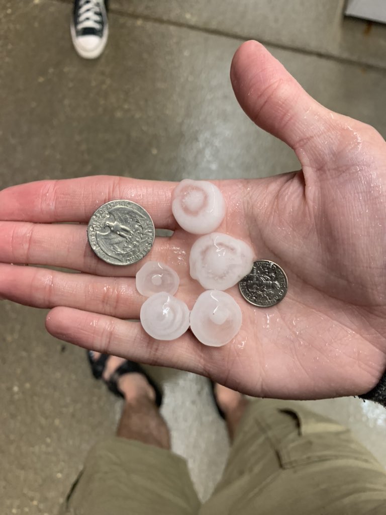
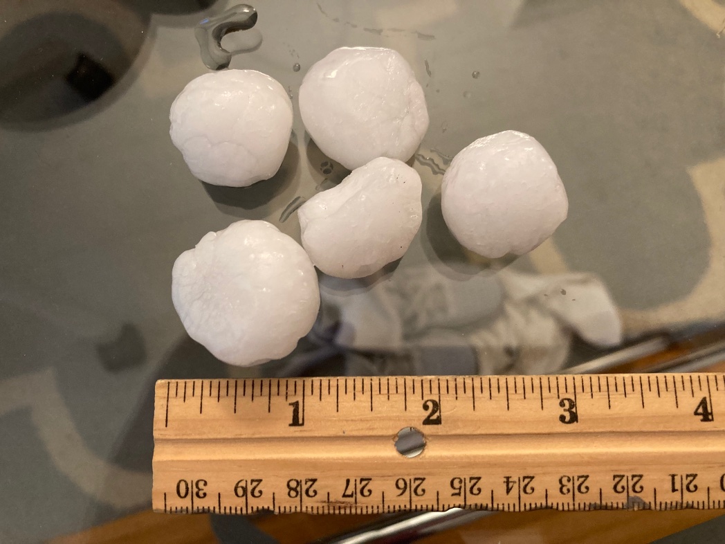
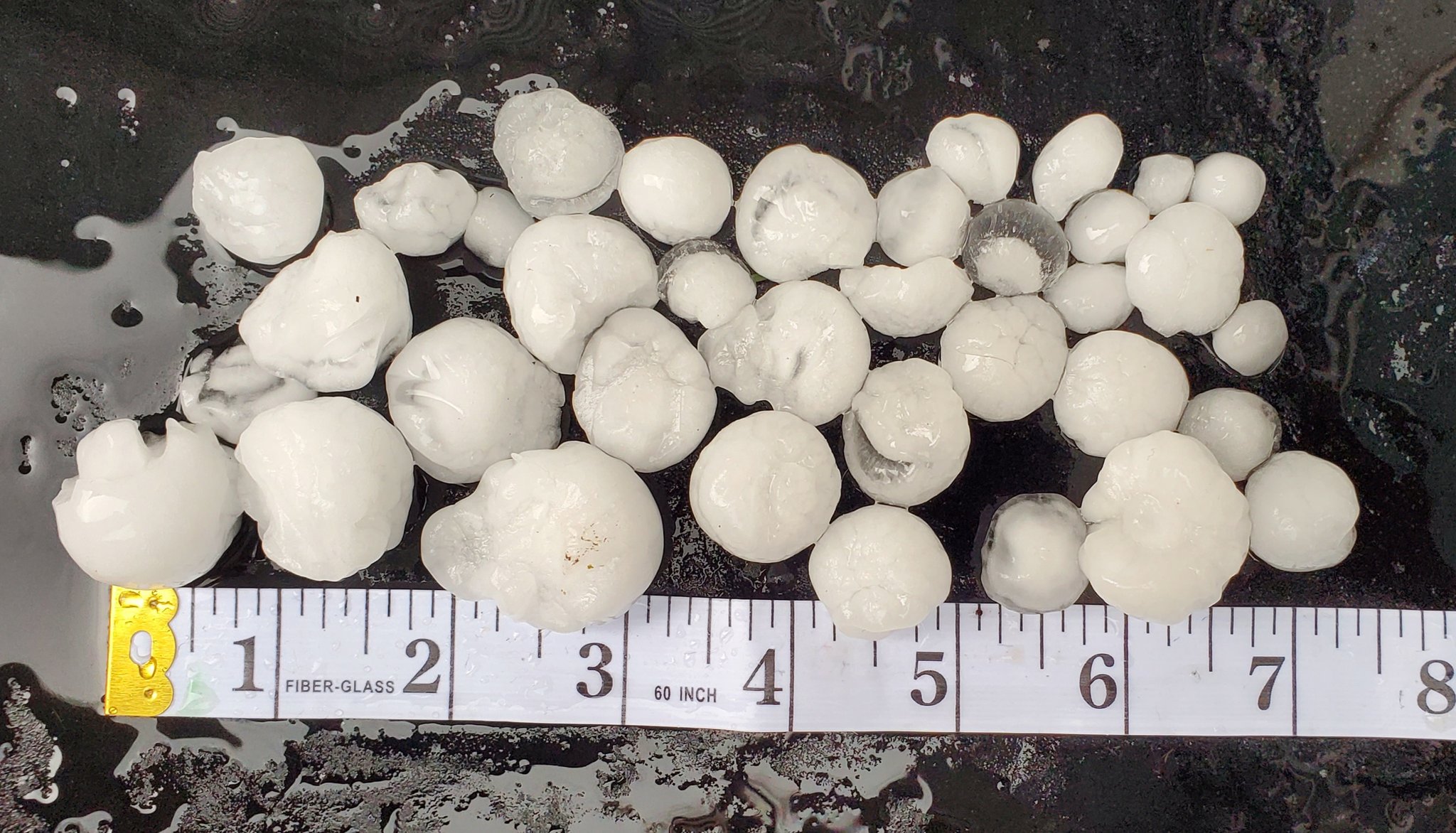
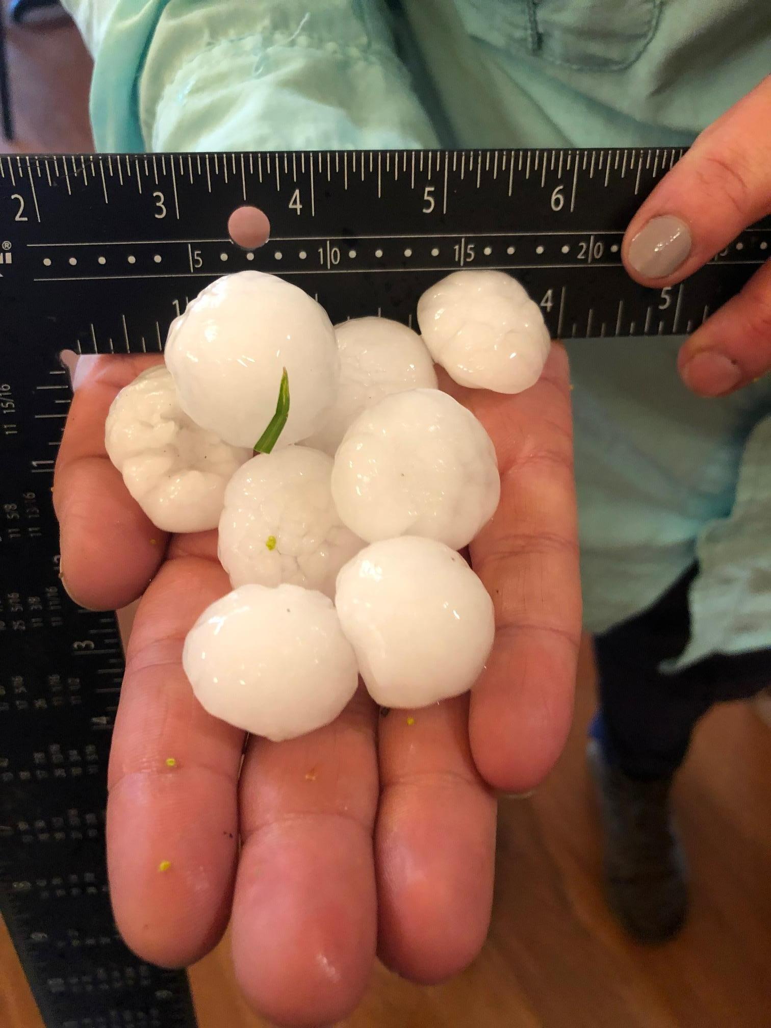
Hail Photos
 |
 |
 |
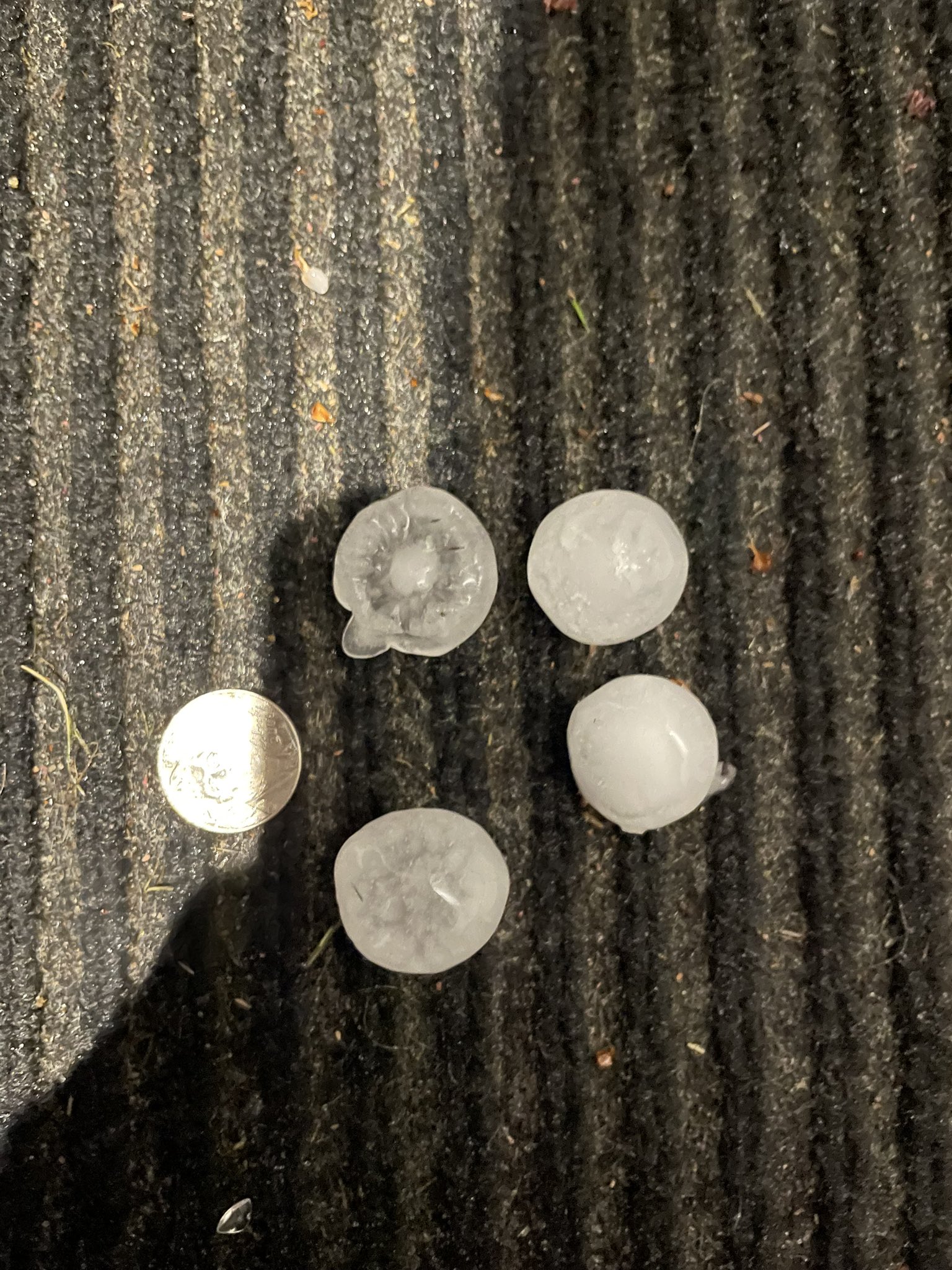 |
| Rochester, MN (Photo by Alicia Zeone) |
Along Freeborn/Mower Co., MN line (Photo by Steve Yezek) |
Southwest Rochester, MN ~1:40pm (Photo by Kelly Classic) |
Town of Shelby, WI (Photo by Steven Hofacker) |
 |
 |
 |
 |
| Hokah, MN (Photo by Erik Creighton) |
Southwest Rochester, MN (Photo by Brianna Tranby) |
Southeast Rochester, MN (Photo by Susie Concilio) |
Salem Township (Olmsted Co, MN) (Photo by Colleen Fitzgerald) |
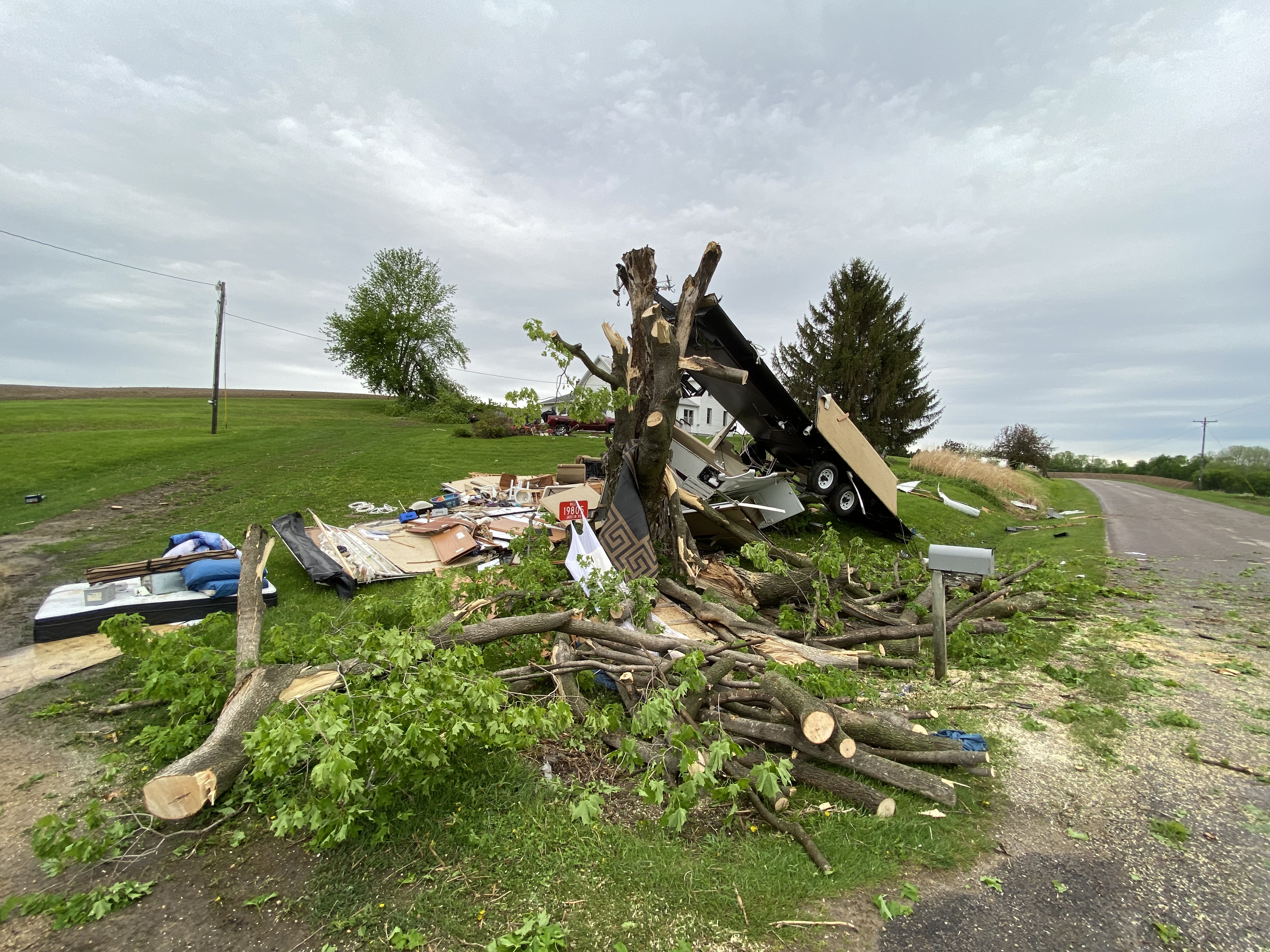
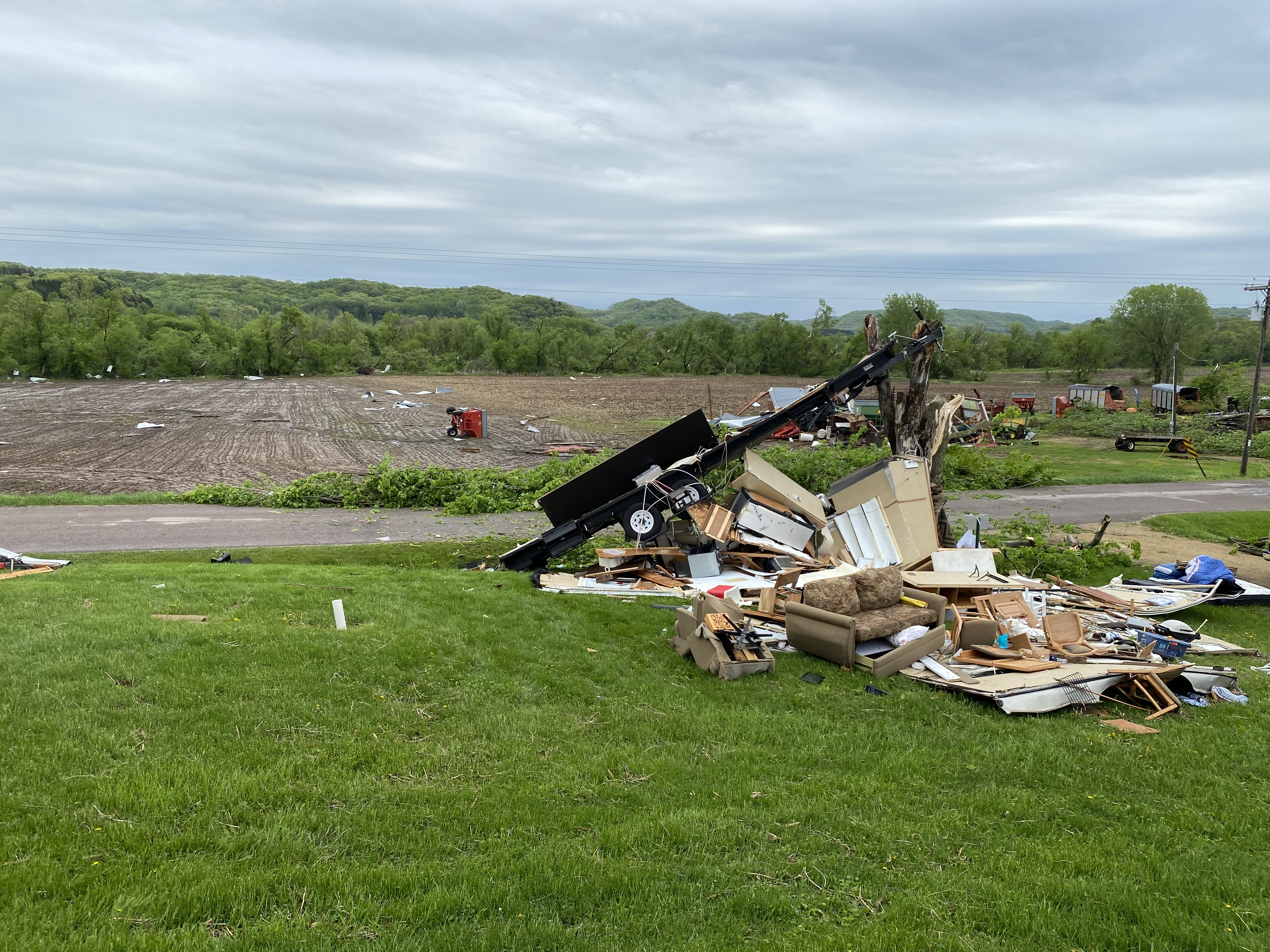
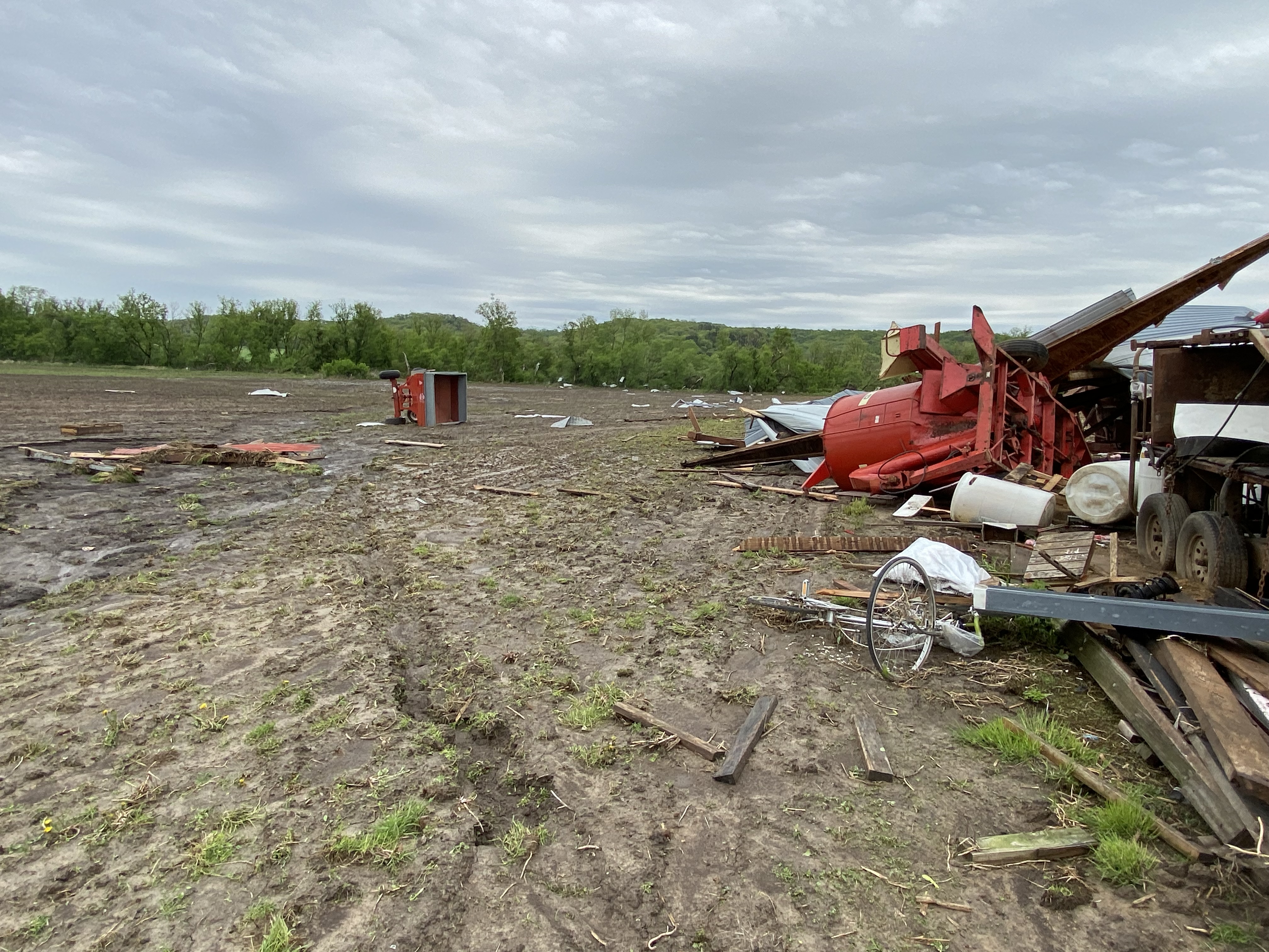
Damage Photos (from Monroe Co., WI tornado)
 |
 |
 |
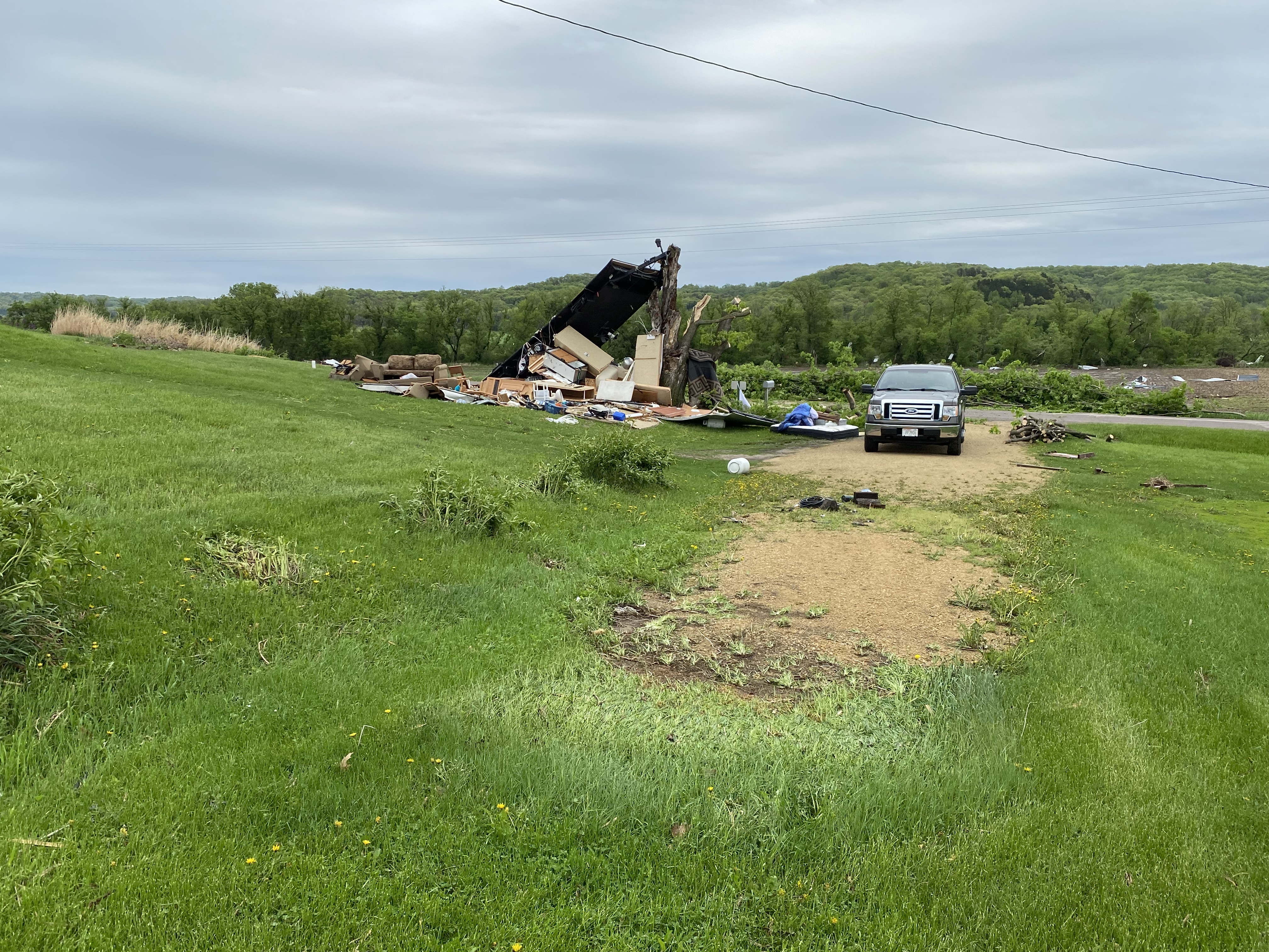 |
| Town of Wells, WI (Courtesy of Monroe Co. Emerg.Mgmt) |
Town of Wells, WI (Courtesy of Monroe Co. Emerg.Mgmt) |
Town of Wells, WI (Courtesy of Monroe Co. Emerg.Mgmt) |
Town of Wells, WI (Courtesy of Monroe Co. Emerg.Mgmt) |
Radar:
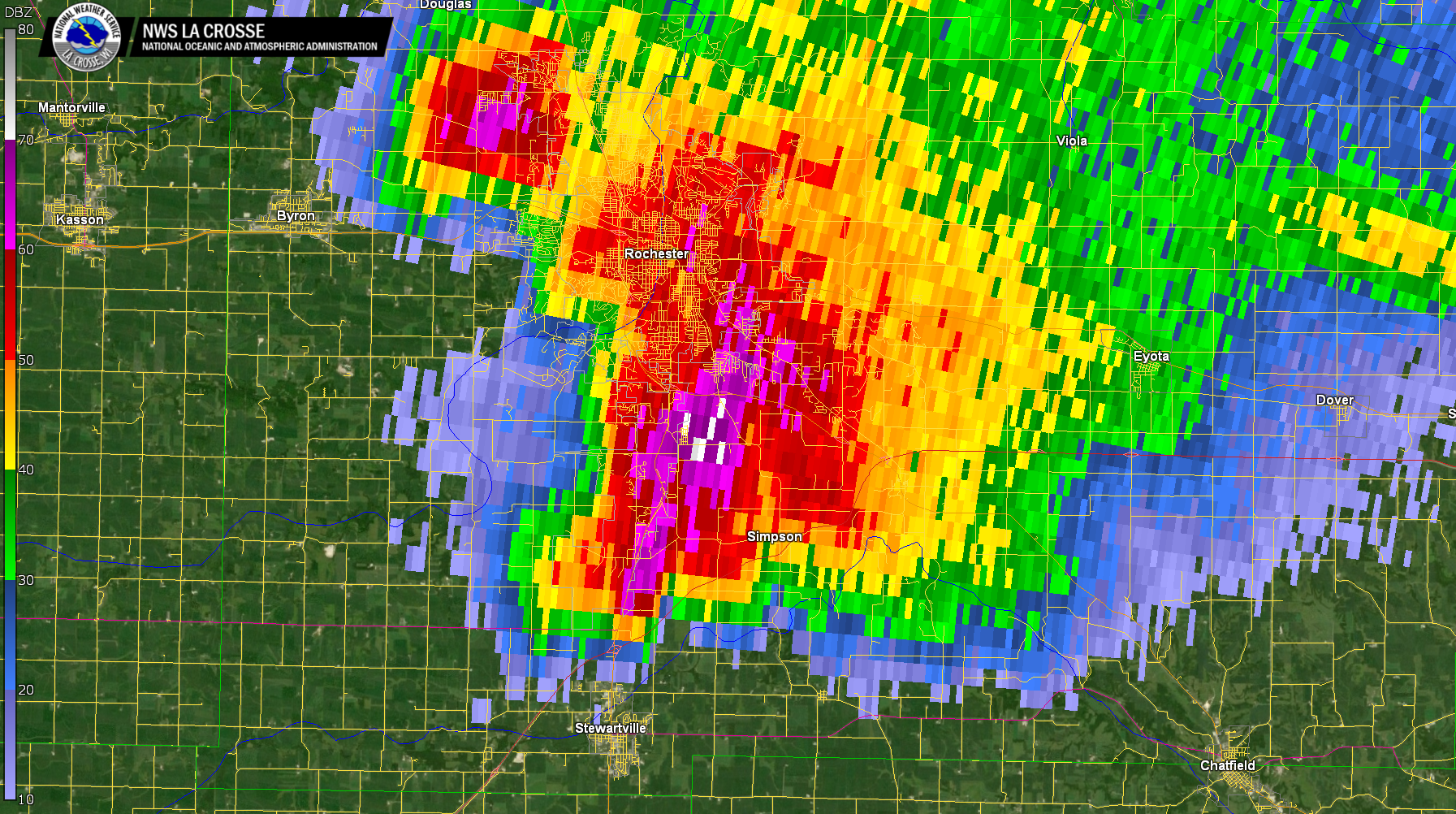 |
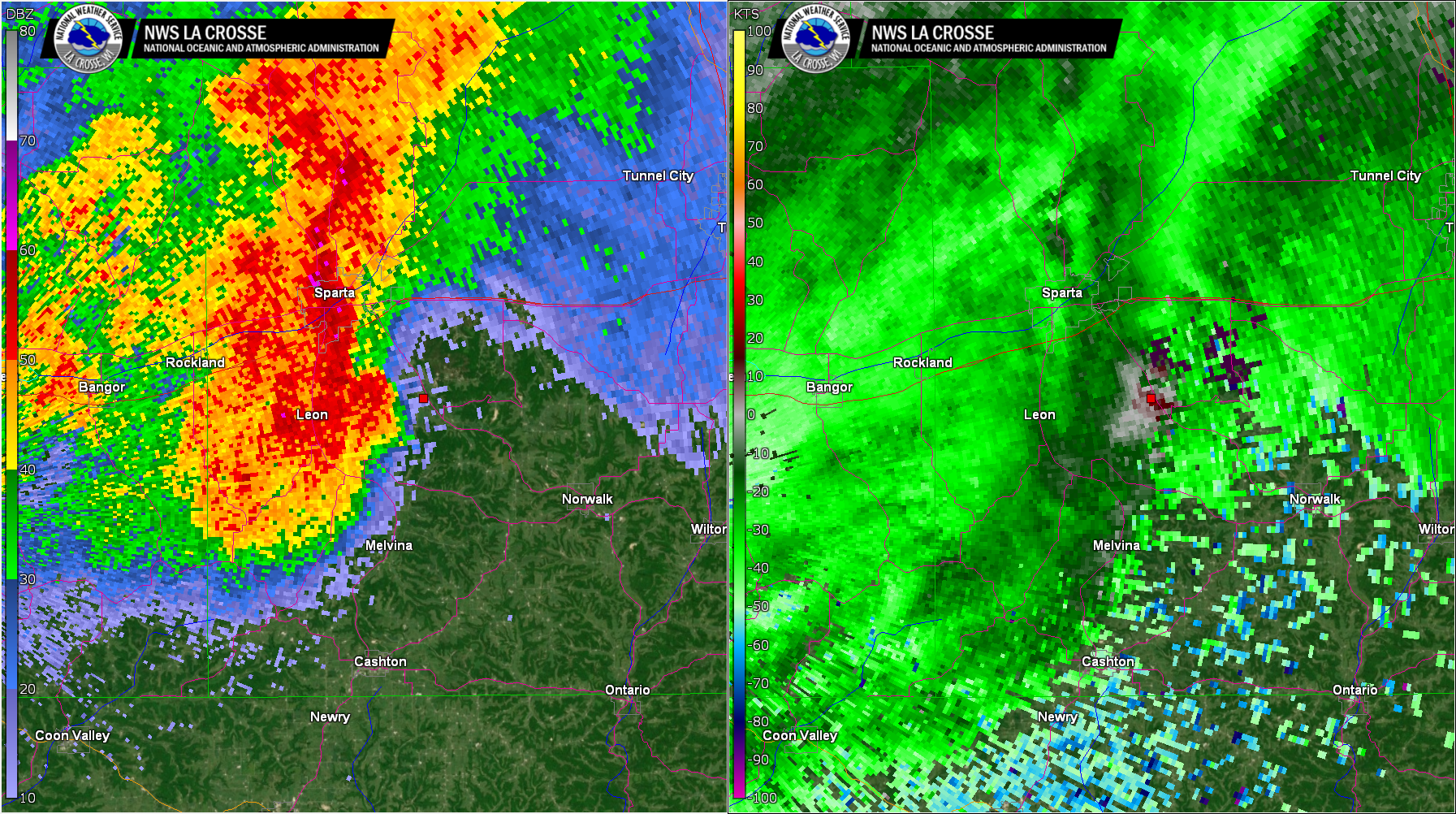 |
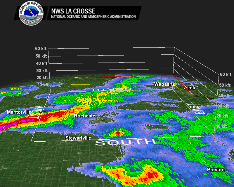 |
| ~1:37 PM as largest hail was falling across south side of Rochester, MN | ~8:21 PM with brief tornado southeast of Sparta, WI | 3D view of the hail core as it passed near Rochester, MN |
Storm Reports
..TIME... ...EVENT... ...CITY LOCATION... ...LAT.LON...
..DATE... ....MAG.... ..COUNTY LOCATION..ST.. ...SOURCE....
..REMARKS..
1224 PM Hail 3 WNW Lyle 43.52N 92.99W
05/19/2022 M1.50 inch Mower MN Public
1229 PM Hail 3 N Lyle 43.54N 92.95W
05/19/2022 M0.75 inch Mower MN Public
Covering the ground with fog forming.
1230 PM Hail Lyle 43.51N 92.94W
05/19/2022 E1.25 inch Mower MN Post Office
1240 PM Hail 1 NE Mapleview 43.70N 92.96W
05/19/2022 M0.25 inch Mower MN Law Enforcement
1248 PM Hail 2 S Adams 43.54N 92.71W
05/19/2022 M1.50 inch Mower MN Fire Dept/Rescue
0115 PM Hail 1 E Kasson 44.03N 92.74W
05/19/2022 E0.70 inch Dodge MN Broadcast Media
0129 PM Hail Byron 44.03N 92.65W
05/19/2022 M0.70 inch Olmsted MN Broadcast Media
0134 PM Hail 1 W Rochester 44.02N 92.49W
05/19/2022 U0.50 inch Olmsted MN Public
Report from mPING: Half-inch (0.50 in.).
0135 PM Hail 1 SW ROCHESTER 44.01N 92.50W
05/19/2022 E1.00 inch Olmsted MN Public
.
0136 PM Hail 1 NW Rochester 44.03N 92.49W
05/19/2022 U0.75 inch Olmsted MN Public
Report from mPING: Dime (0.75 in.).
0137 PM Hail 5 S Rochester 43.94N 92.48W
05/19/2022 M1.50 inch Olmsted MN Amateur Radio
0137 PM Hail 3 S Rochester 43.97N 92.48W
05/19/2022 U1.25 inch Olmsted MN Public
Report from mPING: Half Dollar (1.25 in.).
0138 PM Hail 2 SW Rochester 43.99N 92.50W
05/19/2022 U1.00 inch Olmsted MN Public
Report from mPING: Quarter (1.00 in.).
0139 PM Hail 3 SE Rochester 43.98N 92.44W
05/19/2022 M0.00 inch Olmsted MN Public
0142 PM Hail 2 NW Rochester 44.04N 92.50W
05/19/2022 M0.25 inch Olmsted MN Public
0143 PM Hail 1 E Rochester 44.02N 92.46W
05/19/2022 U0.75 inch Olmsted MN Public
Report from mPING: Dime (0.75 in.).
0144 PM Hail 3 SW Chester 43.98N 92.40W
05/19/2022 U1.00 inch Olmsted MN Public
Report from mPING: Quarter (1.00 in.).
0154 PM Hail 3 ESE Rochester 44.00N 92.43W
05/19/2022 M1.50 inch Olmsted MN Emergency Mngr
0252 PM Flood 3 S Dodge Center 43.98N 92.86W
05/19/2022 Dodge MN Public
Report from mPING: River/Creek overflowing;
Cropland/Yard/Basement Flooding.
0406 PM Hail 6 NNW Genoa 44.19N 92.66W
05/19/2022 U1.00 inch Olmsted MN Public
Report from mPING: Quarter (1.00 in.).
0412 PM Hail 5 NNW Genoa 44.19N 92.65W
05/19/2022 E0.88 inch Olmsted MN Public
0419 PM Hail 4 NE Oronoco 44.21N 92.48W
05/19/2022 E0.25 inch Wabasha MN Public
0533 PM Hail 3 NE Byron 44.07N 92.61W
05/19/2022 M0.70 inch Olmsted MN Trained Spotter
0534 PM Hail 2 SE Douglas 44.08N 92.54W
05/19/2022 U0.50 inch Olmsted MN Public
Report from mPING: Half-inch (0.50 in.).
0537 PM Hail 3 SE Douglas 44.07N 92.54W
05/19/2022 U0.50 inch Olmsted MN Public
Report from mPING: Half-inch (0.50 in.).
0537 PM Hail 2 SSE Douglas 44.08N 92.55W
05/19/2022 E0.25 inch Olmsted MN Public
0540 PM Hail Rochester 44.02N 92.48W
05/19/2022 E0.25 inch Olmsted MN Public
0548 PM Hail 1 WNW Hayfield 43.89N 92.86W
05/19/2022 E0.70 inch Dodge MN Public
0604 PM Hail 5 W Lake City 44.44N 92.37W
05/19/2022 U0.75 inch Wabasha MN Public
Report from mPING: Dime (0.75 in.).
0622 PM Hail Mantorville 44.07N 92.75W
05/19/2022 M0.50 inch Dodge MN Trained Spotter
0634 PM Hail 5 S Claremont 43.98N 92.98W
05/19/2022 E0.25 inch Dodge MN Public
0720 PM Funnel Cloud 3 WNW Elkton 43.67N 92.78W
05/19/2022 Mower MN Public
0740 PM Hail Fountain 43.74N 92.13W
05/19/2022 M0.70 inch Fillmore MN Public
0745 PM Hail 4 S Rochester 43.95N 92.47W
05/19/2022 E0.88 inch Olmsted MN Trained Spotter
Preliminary Spotter Report via
spotternetwork.org.
0745 PM Tstm Wnd Dmg 2 E Whalan 43.73N 91.89W
05/19/2022 Fillmore MN Trained Spotter
Large, fallen tree, estimated 4ft diameter
trunk-size.
0753 PM Tstm Wnd Gst 2 ENE Onalaska 43.89N 91.18W
05/19/2022 M50 MPH La Crosse WI NWS Employee
0755 PM Tstm Wnd Gst 2 NNE French Island 43.88N 91.25W
05/19/2022 M62 MPH La Crosse WI ASOS
ASOS station KLSE La Crosse Regional
Airport.
0755 PM Tstm Wnd Gst 2 E Onalaska 43.89N 91.18W
05/19/2022 M50 MPH La Crosse WI Mesonet
Mesonet station GW0323 Onalaska.
0755 PM Hail 2 E Whalan 43.73N 91.90W
05/19/2022 U0.50 inch Fillmore MN Public
Report from mPING: Half-inch (0.50 in.).
0800 PM Hail Bratsberg 43.74N 91.77W
05/19/2022 M0.50 inch Fillmore MN Public
0800 PM Tstm Wnd Dmg 1 NNE Barre Mills 43.85N 91.11W
05/19/2022 La Crosse WI Public
Major roof damage.
0815 PM Tstm Wnd Gst 2 NE Mound Prairie 43.80N 91.43W
05/19/2022 M45 MPH Houston MN CO-OP Observer
0820 PM Hail 1 SE La Crosse 43.81N 91.22W
05/19/2022 M0.88 inch La Crosse WI Trained Spotter
0820 PM Hail 2 E La Crosse 43.82N 91.19W
05/19/2022 M1.00 inch La Crosse WI Official NWS Obs
0820 PM TORNADO 5 SE SPARTA 43.89N 90.75W
05/19/2022 MONROE WI EMERGENCY MNGR
BRIEF TORNADO DAMAGED A SHED, NEARBY HOUSE,
AND TREES. A CAMPER WAS TOSSED AND
DESTROYED.
0821 PM Hail 1 S La Crosse 43.81N 91.24W
05/19/2022 U0.50 inch La Crosse WI Public
Report from mPING: Half-inch (0.50 in.).
0825 PM Tstm Wnd Gst 2 SSW La Crosse 43.79N 91.24W
05/19/2022 E45 MPH La Crosse WI NWS Employee
0827 PM Hail 3 S La Crosse 43.79N 91.24W
05/19/2022 E0.25 inch La Crosse WI Public
0830 PM Hail 2 SSE La Crosse 43.79N 91.22W
05/19/2022 E1.00 inch La Crosse WI Public
0832 PM Hail 5 NE Brownsville 43.75N 91.20W
05/19/2022 U0.75 inch La Crosse WI Public
Report from mPING: Dime (0.75 in.).
0834 PM Hail 1 S Goodview 44.05N 91.71W
05/19/2022 M0.50 inch Winona MN Public
0835 PM Hail Winona 44.05N 91.66W
05/19/2022 E0.70 inch Winona MN Public
0835 PM Hail 1 SSW Hokah 43.75N 91.36W
05/19/2022 M1.25 inch Houston MN Trained Spotter
0835 PM Hail 3 SE Ridgeway 43.89N 91.53W
05/19/2022 E0.50 inch Winona MN Public
0837 PM Hail 1 SSW La Crosse 43.81N 91.25W
05/19/2022 M1.00 inch La Crosse WI Broadcast Media
0838 PM Hail Ridgeway 43.92N 91.57W
05/19/2022 M0.25 inch Winona MN Emergency Mngr
0838 PM Hail 1 SE Winona 44.03N 91.64W
05/19/2022 U0.50 inch Winona MN Public
Report from mPING: Half-inch (0.50 in.).
0839 PM Hail 1 E Winona 44.04N 91.64W
05/19/2022 U0.50 inch Winona MN Public
Report from mPING: Half-inch (0.50 in.).
0840 PM Hail 2 W Saint Joseph 43.78N 91.07W
05/19/2022 E1.25 inch La Crosse WI Public
0844 PM Flash Flood 1 WNW La Crosse 43.83N 91.25W
05/19/2022 La Crosse WI Public
Report from mPING: Street/road flooding;
Street/road closed; Vehicles stranded.
0845 PM Hail New Hartford 43.88N 91.48W
05/19/2022 M1.00 inch Winona MN Law Enforcement
0847 PM Hail 4 S La Crosse 43.77N 91.21W
05/19/2022 U0.50 inch La Crosse WI Public
Report from mPING: Half-inch (0.50 in.).
0848 PM Hail Dakota 43.91N 91.36W
05/19/2022 M0.70 inch Winona MN Trained Spotter
0855 PM Flood 2 SSE La Crosse 43.80N 91.22W
05/19/2022 La Crosse WI NWS Employee
Street flooding along Losey Blvd. Cars
stranded. Road blocked for a time.
0855 PM Hail 5 SSW Barre Mills 43.77N 91.16W
05/19/2022 M0.88 inch La Crosse WI Public
0900 PM Hail 2 NW Onalaska 43.91N 91.23W
05/19/2022 M0.50 inch La Crosse WI Public
0902 PM Hail 1 NW Onalaska 43.90N 91.23W
05/19/2022 M0.50 inch La Crosse WI Public
0903 PM Hail Oakdale 43.97N 90.38W
05/19/2022 M0.75 inch Monroe WI Fire Dept/Rescue
0909 PM Tstm Wnd Gst Camp Douglas 43.92N 90.27W
05/19/2022 M48 MPH Juneau WI AWOS
AWOS station KVOK Volk Field.
0909 PM Hail 3 E Onalaska 43.89N 91.17W
05/19/2022 U0.50 inch La Crosse WI Public
Report from mPING: Half-inch (0.50 in.).
0915 PM Hail Westby 43.66N 90.86W
05/19/2022 M1.25 inch Vernon WI Emergency Mngr
0915 PM Hail Cashton 43.75N 90.78W
05/19/2022 M0.25 inch Monroe WI Emergency Mngr
0916 PM Tstm Wnd Dmg 1 W West Salem 43.90N 91.10W
05/19/2022 La Crosse WI Public
Report from mPING: 1-inch tree limbs broken;
Shingles blown off.
0925 PM Hail 1 SE Holmen 43.94N 91.25W
05/19/2022 U0.50 inch La Crosse WI Public
Report from mPING: Half-inch (0.50 in.).
0926 PM Hail 4 E Holmen 43.98N 91.19W
05/19/2022 U0.75 inch La Crosse WI Public
Report from mPING: Dime (0.75 in.).
0932 PM Hail 1 N Hillsboro 43.66N 90.34W
05/19/2022 E0.50 inch Vernon WI Public
Report from mPING: Half-inch (0.50 in.).
0934 PM Hail 1 SE Elroy 43.73N 90.26W
05/19/2022 U0.50 inch Juneau WI Public
Report from mPING: Half-inch (0.50 in.).
0938 PM Hail 1 W West Salem 43.90N 91.11W
05/19/2022 U1.00 inch La Crosse WI Public
Report from mPING: Quarter (1.00 in.).
0943 PM Tstm Wnd Gst 1 N Stewartville 43.87N 92.49W
05/19/2022 M48 MPH Olmsted MN Public
0948 PM Hail 2 NE Bangor 43.91N 90.98W
05/19/2022 U0.50 inch La Crosse WI Public
Report from mPING: Half-inch (0.50 in.).
0950 PM Hail 2 NNE Bangor 43.91N 90.98W
05/19/2022 U0.75 inch La Crosse WI Public
Report from mPING: Dime (0.75 in.).
1016 PM Hail Holmen 43.96N 91.26W
05/19/2022 U1.50 inch La Crosse WI Public
Report from mPING: Ping Pong Ball (1.50
in.).
1045 PM Flash Flood 1 N Pickwick 44.00N 91.60W
05/19/2022 Winona MN Public
Mudslides reported across roads in Homer.
1115 PM Hail 3 NE Union Center 43.72N 90.21W
05/19/2022 U0.75 inch Juneau WI Public
Report from mPING: Dime (0.75 in.).
1120 PM Hail 1 WSW Hillsboro 43.65N 90.35W
05/19/2022 M0.25 inch Vernon WI Public
0130 AM Hail New Rome 44.24N 89.88W
05/20/2022 M0.25 inch Adams WI Public
0159 AM Tstm Wnd Gst 3 N Stewartville 43.90N 92.49W
05/20/2022 M63 MPH Olmsted MN Official NWS Obs
0727 AM Hail 2 SSE Holmen 43.93N 91.24W
05/20/2022 M0.25 inch La Crosse WI NWS Employee
0845 AM Hail 1 WNW French Island 43.87N 91.27W
05/20/2022 M0.25 inch La Crosse WI NWS Employee
0852 AM Hail 1 SE Onalaska 43.88N 91.21W
05/20/2022 U0.50 inch La Crosse WI Public
Report from mPING: Half-inch (0.50 in.).
&&
$$
Rain Reports
...PRECIPITATION REPORTS...

Location                     Amount    Time/Date       Lat/Lon

...Iowa...

...Allamakee County...
Postville 5.5 NE             0.18 in   0700 AM 05/20   43.14N/91.49W
3 SE Waterville              0.16 in   0607 AM 05/20   43.17N/91.24W

...Chickasaw County...
Fredericksburg 0.3 S         0.69 in   0800 AM 05/20   42.96N/92.20W
New Hampton 0.4 SW           0.31 in   0700 AM 05/20   43.06N/92.32W
NEW HAMPTON                  0.24 in   0747 AM 05/20   43.05N/92.30W
Ionia 2W                     0.08 in   1045 AM 05/20   43.03N/92.50W

...Clayton County...
McGregor                     0.39 in   0749 AM 05/20   43.02N/91.19W
1 WSW Marquette              0.23 in   0700 AM 05/20   43.04N/91.21W
McGregor 6.4 WNW             0.19 in   0705 AM 05/20   43.07N/91.29W
Monona                       0.17 in   0749 AM 05/20   43.04N/91.39W

...Fayette County...
Waucoma 3.2 S                0.36 in   0648 AM 05/20   43.01N/92.03W
Fayette                      0.15 in   0730 AM 05/20   42.88N/91.83W
Eldorado 1E - Turkey River   0.01 in   1045 AM 05/20   43.05N/91.81W


...Floyd County...
Nora Springs 2.4 SSE         0.49 in   0700 AM 05/20   43.11N/92.99W
Charles City                 0.42 in   0745 AM 05/20   43.07N/92.68W
Nashua 2SW                   0.34 in   0700 AM 05/20   42.94N/92.57W
2 NE Dougherty               0.34 in   0745 AM 05/20   42.95N/93.01W

...Howard County...
Riceville                    0.11 in   0746 AM 05/20   43.36N/92.48W
Elma                         0.07 in   0700 AM 05/20   43.24N/92.44W
Saratoga                     0.07 in   0745 AM 05/20   43.35N/92.42W

...Mitchell County...
St Ansgar                    0.22 in   0630 AM 05/20   43.38N/92.92W
Osage                        0.18 in   0700 AM 05/20   43.28N/92.81W
Osage 4.7 E                  0.14 in   0700 AM 05/20   43.28N/92.72W


...Winneshiek County...
1 ENE Jackson Junction       0.27 in   0750 AM 05/20   43.11N/92.04W
Spillville                   0.20 in   0900 AM 05/20   43.21N/91.95W
Decorah 4.9SE                0.20 in   0700 AM 05/20   43.26N/91.70W
Decorah                      0.19 in   1045 AM 05/20   43.30N/91.80W
7 ENE Decorah                0.13 in   0818 AM 05/20   43.34N/91.64W

...Minnesota...

...Dodge County...
Mantorville 1.9 ESE          1.59 in   0700 AM 05/20   44.05N/92.72W
Claremont 3.1 S              1.39 in   0700 AM 05/20   44.00N/92.99W
Mantorville 1.1 SSE          1.35 in   0700 AM 05/20   44.05N/92.74W
Claremont 2.5 ESE            1.23 in   0800 AM 05/20   44.04N/92.95W
Hayfield 0.6 WNW             1.06 in   0700 AM 05/20   43.89N/92.86W
Hayfield                     0.94 in   0747 AM 05/20   43.89N/92.85W
Hayfield 0.3 SSE             0.91 in   0830 AM 05/20   43.89N/92.85W

...Fillmore County...
Chatfield 9.0 ESE            2.43 in   0650 AM 05/20   43.79N/92.03W
Chatfield 6.3 ESE            1.91 in   0700 AM 05/20   43.81N/92.08W
1 NNW Fillmore               1.51 in   0730 AM 05/20   43.76N/92.27W
Wykoff 3.1 NW                1.28 in   0700 AM 05/20   43.74N/92.31W
6 N Spring Valley            1.17 in   0700 AM 05/20   43.78N/92.39W
Spring Valley                0.20 in   0700 AM 05/20   43.69N/92.39W
Lanesboro                    0.13 in   0730 AM 05/20   43.72N/91.98W

...Houston County...
La Crescent 0.7 N            2.14 in   0702 AM 05/20   43.84N/91.30W
Mound Prairie                1.57 in   1045 AM 05/20   43.78N/91.45W
Houston                      1.54 in   0746 AM 05/20   43.77N/91.58W
La Crescent 5.4 SW           1.47 in   0700 AM 05/20   43.78N/91.39W
1 ENE Mound Prairie          1.35 in   0700 AM 05/20   43.79N/91.42W
Hokah 4 NW                   1.35 in   0700 AM 05/20   43.80N/91.43W
Hokah                        1.29 in   0740 AM 05/20   43.80N/91.43W

...Mower County...
Waltham 2.0 SE               2.08 in   0800 AM 05/20   43.80N/92.85W
Waltham 2.9 SW               1.53 in   0800 AM 05/20   43.79N/92.91W
Lansing - Cedar River        0.96 in   1030 AM 05/20   43.75N/92.96W
Austin Waste Water Treatment 0.35 in   0700 AM 05/20   43.65N/92.97W
Ostrander 5.1 WNW            0.30 in   0700 AM 05/20   43.65N/92.52W
Austin                       0.30 in   0748 AM 05/20   43.65N/93.00W
Austin 1.5 WSW               0.26 in   0700 AM 05/20   43.67N/93.00W
Austin 2.4 W                 0.23 in   0700 AM 05/20   43.67N/93.02W
Dobbins Creek                0.13 in   1030 AM 05/20   43.68N/92.94W

...Olmsted County...
3 SSW Predmore               3.80 in   0628 AM 05/20   43.90N/92.34W
Stewartville 4.3 E           2.85 in   0415 AM 05/20   43.86N/92.40W
3 SW Cummingsville           2.40 in   1040 AM 05/20   43.85N/92.30W
1 W Chester                  1.91 in   0618 AM 05/20   44.00N/92.38W
Byron                        1.84 in   0745 AM 05/20   44.04N/92.64W
Chatfield                    1.83 in   0959 PM 05/19   43.85N/92.19W
2 W High Forest              1.70 in   0700 AM 05/20   43.85N/92.59W
Rochester 2.4 WNW            1.64 in   0800 AM 05/20   44.02N/92.53W
Rochester 1.5 WSW            1.60 in   0600 AM 05/20   44.00N/92.50W
Rochester                    1.41 in   0745 AM 05/20   44.09N/92.49W
Rochester 5.5 N              1.38 in   0930 AM 05/20   44.10N/92.47W
Rochester 4.2 N              1.38 in   0600 AM 05/20   44.08N/92.49W
Rochester 2.0 NNE            1.35 in   0700 AM 05/20   44.04N/92.47W
Rochester 4.7 N              1.33 in   0700 AM 05/20   44.08N/92.48W
4 NNW Rochester              1.32 in   0706 AM 05/20   44.07N/92.49W
Rochester 1.6 ENE            1.26 in   0800 AM 05/20   44.03N/92.45W
3 W Rochester                1.26 in   1030 AM 05/20   44.02N/92.53W
Saint Charles 7.6 NNW        1.22 in   0700 AM 05/20   44.08N/92.10W
Rochester 5.7 N              1.21 in   0750 AM 05/20   44.10N/92.46W
Rochester 4.7 ENE            1.10 in   0800 AM 05/20   44.04N/92.39W
2 NE Rochester               1.06 in   0600 AM 05/20   44.04N/92.44W
Rochester International Airp 1.06 in   0751 AM 05/20   43.90N/92.50W
3 ENE Rochester              1.03 in   1030 AM 05/20   44.03N/92.43W
Rochester 5.8 ENE            0.98 in   0700 AM 05/20   44.05N/92.37W
Rochester-Beltline Bear Cree 0.98 in   1030 AM 05/20   44.01N/92.45W
Rochester-Cascade Creek      0.88 in   1030 AM 05/20   44.03N/92.47W
Elgin 2SSW                   0.88 in   0700 AM 05/20   44.10N/92.27W
5 WSW Rochester              0.85 in   0700 AM 05/20   43.98N/92.56W
6 NNW Genoa                  0.75 in   0700 AM 05/20   44.19N/92.65W
Oronoco 3.3 ESE              0.71 in   0715 AM 05/20   44.14N/92.48W
Eyota 2NE                    0.51 in   1030 AM 05/20   44.02N/92.20W
Rochester                    0.48 in   0745 AM 05/20   44.18N/92.41W
Elba 4.7 SW                  0.43 in   1000 AM 05/20   44.04N/92.09W
1 W Oronoco                  0.35 in   0730 AM 05/20   44.17N/92.55W

...Wabasha County...
Lake City 1.0 SE             1.10 in   0800 AM 05/20   44.43N/92.27W
Lake City                    1.05 in   0745 AM 05/20   44.44N/92.28W
Lake City 0.9 E              1.00 in   0800 AM 05/20   44.44N/92.26W
Zumbro Falls 3.5 SSW         0.81 in   0838 AM 05/20   44.24N/92.46W
Theilman 1 SSW               0.72 in   0730 AM 05/20   44.28N/92.19W
Plainview                    0.59 in   0742 AM 05/20   44.17N/92.17W
Wabasha 6.2 WNW              0.58 in   0700 AM 05/20   44.39N/92.16W
Wabasha                      0.52 in   0748 AM 05/20   44.30N/92.00W
1 N Kellogg                  0.41 in   0700 AM 05/20   44.32N/92.00W
Lake City                    0.39 in   0745 AM 05/20   44.32N/92.44W
Mazeppa (IFLOWS)             0.28 in   0446 AM 05/20   44.27N/92.55W
3 ESE Mazeppa                0.27 in   0730 AM 05/20   44.26N/92.49W

...Winona County...
Winona 1.3 SSW               3.88 in   0730 AM 05/20   44.03N/91.68W
Winona 5.1 WSW               3.69 in   1000 AM 05/20   44.03N/91.77W
Stockton                     3.54 in   0624 AM 05/20   44.03N/91.77W
Stockton 1.2 W               3.41 in   0700 AM 05/20   44.03N/91.79W
1 ESE Winona                 3.30 in   0745 AM 05/20   44.04N/91.63W
Winona 1.9 ESE               3.22 in   0623 AM 05/20   44.04N/91.63W
Lewiston 0.2 NW              3.04 in   0700 AM 05/20   43.99N/91.87W
Winona 12.0 ESE              3.02 in   0700 AM 05/20   43.99N/91.44W
Lawrence                     2.33 in   0745 AM 05/20   43.88N/91.34W
Lewiston 9.1 SSE             2.23 in   0700 AM 05/20   43.86N/91.80W
La Crescent 4.0 NNW          1.98 in   0700 AM 05/20   43.88N/91.34W
Altura 5w                    1.59 in   0700 AM 05/20   44.06N/92.04W
1 WSW Elba                   1.13 in   1045 AM 05/20   44.09N/92.03W
Dakota                       1.12 in   0715 AM 05/20   43.91N/91.36W
3 SW Elba                    0.94 in   1030 AM 05/20   44.06N/92.05W
4.2 N Rollingstone           0.75 in   0800 AM 05/20   44.16N/91.81W
Whitewater State Park        0.75 in   1030 AM 05/20   44.05N/92.05W
Minneiska 1.1 SW             0.71 in   0700 AM 05/20   44.18N/91.88W
Beaver                       0.68 in   1045 AM 05/20   44.15N/92.00W

...Wisconsin...

...Adams County...
Oxford 4.3 W                 1.76 in   0800 AM 05/20   43.79N/89.65W
Oxford 4.0 W                 1.62 in   0700 AM 05/20   43.79N/89.64W
Nekoosa 8.0 SSE              1.37 in   0800 AM 05/20   44.21N/89.85W
Grand Marsh 1.0 W            1.16 in   0700 AM 05/20   43.89N/89.73W
0.6 W Friendship             0.88 in   0700 AM 05/20   43.98N/89.83W
Friendship 6.4 N             0.61 in   0700 AM 05/20   44.06N/89.80W

...Buffalo County...
Mondovi 12.1 SSE             0.37 in   0620 AM 05/20   44.40N/91.60W
Mondovi                      0.12 in   0700 PM 05/19   44.56N/91.67W

...Clark County...
Greenwood 0.6 NNW            0.29 in   0700 AM 05/20   44.77N/90.60W
Owen 1E                      0.27 in   0700 AM 05/20   44.95N/90.55W

...Crawford County...
Prairie Du Chien 1.4 N       0.24 in   0700 AM 05/20   43.06N/91.14W
Prairie Du Chien  Airport    0.24 in   0755 AM 05/20   43.02N/91.12W
0.6 NE Prairie Du Chien      0.23 in   0700 AM 05/20   43.05N/91.13W
Eastman 2.4 NNE              0.21 in   0700 AM 05/20   43.20N/91.00W

...Grant County...
Platteville                  1.01 in   0745 AM 05/20   42.74N/90.46W
Muscoda 0.5 WSW              0.34 in   1011 AM 05/20   43.18N/90.44W
Muscoda                      0.18 in   0750 AM 05/20   43.19N/90.46W
Boscobel Airport             0.15 in   0753 AM 05/20   43.15N/90.68W
Boscobel                     0.13 in   0703 AM 05/20   43.15N/90.68W
Patch Grove 0.1 NNW          0.11 in   0700 AM 05/20   42.94N/90.97W
Bloomington 3.5 N            0.10 in   0531 AM 05/20   42.94N/90.92W

...Jackson County...
Melrose 3.6 W                1.51 in   0700 AM 05/20   44.13N/91.07W
Mather 3NW                   1.10 in   0700 AM 05/20   44.17N/90.35W
Black River Falls 1.7 NNE    0.81 in   0700 AM 05/20   44.32N/90.83W
1 E Black River Falls        0.78 in   0715 AM 05/20   44.30N/90.73W
Black River Falls Area Airpo 0.46 in   0735 AM 05/20   44.25N/90.85W

...Juneau County...
New Lisbon                   3.00 in   1140 PM 05/19   43.88N/90.16W
New Lisbon                   2.19 in   0745 AM 05/20   43.87N/90.17W
Mauston Airport              1.89 in   0735 AM 05/20   43.83N/90.13W
NECEDAH NWR RY DAM NECEDAH 5 1.81 in   1010 AM 05/20   44.06N/90.17W
Mauston                      1.73 in   0747 AM 05/20   43.80N/90.07W
1.0 E Mauston                1.64 in   0900 AM 05/20   43.79N/90.06W
Volk Field                   1.56 in   0956 AM 05/20   43.92N/90.27W
Mauston 7.6 NE               1.40 in   0700 AM 05/20   43.88N/89.98W
Necedah                      0.81 in   0748 AM 05/20   44.03N/90.08W
0.6 W Necedah                0.48 in   0748 AM 05/20   44.02N/90.08W

...La Crosse County...
Melrose 8.2 SSW              3.40 in   0800 AM 05/20   44.02N/91.06W
1 WNW Holmen                 3.22 in   0550 AM 05/20   43.97N/91.27W
Holmen 2 S                   3.22 in   0700 AM 05/20   43.93N/91.25W
Onalaska 2N                  3.21 in   0735 AM 05/20   43.91N/91.23W
1 WSW West Salem             2.53 in   0700 AM 05/20   43.90N/91.10W
West Salem 0.7 W             2.53 in   0700 AM 05/20   43.90N/91.10W
Onalaska                     2.32 in   0745 AM 05/20   43.89N/91.18W
Onalaska 1.9 E               2.28 in   0700 AM 05/20   43.89N/91.18W
La Crosse                    2.23 in   1008 AM 05/20   43.82N/91.19W
La Crosse 2.4 S              1.83 in   0800 AM 05/20   43.79N/91.23W
La Crosse Regional Airport   1.67 in   0753 AM 05/20   43.88N/91.25W
La Crosse 4NNW               1.64 in   0730 AM 05/20   43.87N/91.27W
La Crosse 5.4 SE             1.62 in   0800 AM 05/20   43.77N/91.17W
Coon Valley 4.5 NNW          1.30 in   0700 AM 05/20   43.76N/91.06W
La Crosse 4.4 SSE            1.29 in   0700 AM 05/20   43.77N/91.21W
2 E Onalaska                 0.75 in   0904 PM 05/19   43.89N/91.18W

...Monroe County...
Sparta 0.6 NW                3.75 in   0700 AM 05/20   43.95N/90.82W
0.5 SW Sparta                3.25 in   0800 AM 05/20   43.94N/90.82W
Sparta/Fort McCoy Airport    3.14 in   0958 AM 05/20   43.97N/90.73W
Tomah 7.5 SSW                2.80 in   0800 AM 05/20   43.90N/90.58W
Warrens 4.7 WSW              1.85 in   0700 AM 05/20   44.10N/90.59W
Cashton 3 NNW                1.83 in   0737 AM 05/20   43.79N/90.80W
1 NE Tomah                   1.80 in   0800 AM 05/20   44.00N/90.50W
2 E Cataract                 1.03 in   0748 AM 05/20   44.09N/90.79W

...Richland County...
1 SSE Richland Center        0.04 in   0749 AM 05/20   43.32N/90.38W
Richland Center 4 N          0.03 in   0700 AM 05/20   43.40N/90.39W

...Taylor County...
3 NE Lublin                  0.56 in   0714 AM 05/20   45.11N/90.69W
6 W Goodrich                 0.55 in   0851 AM 05/20   45.14N/90.20W
Medford                      0.49 in   0745 AM 05/20   45.30N/90.30W
Gilman 8.2 NNW               0.46 in   0800 AM 05/20   45.28N/90.86W
Medford 0.8 ENE              0.45 in   0700 AM 05/20   45.14N/90.33W
Medford Airport              0.45 in   0755 AM 05/20   45.10N/90.30W
Westboro                     0.43 in   0750 AM 05/20   45.37N/90.31W

...Trempealeau County...
1 NW Trempealeau             3.53 in   0630 AM 05/20   44.03N/91.46W
4 NW Stevenstown             2.80 in   0630 AM 05/20   44.07N/91.23W
Galesville 4.7 E             2.02 in   0810 AM 05/20   44.08N/91.26W
Trempealeau                  1.71 in   0745 AM 05/20   44.07N/91.51W
Galesville 1.0 NE            1.65 in   0600 AM 05/20   44.10N/91.34W
Trempealeau 7.6 NNW          1.50 in   0700 AM 05/20   44.11N/91.48W
Ettrick 4.0 WNW              0.86 in   0657 AM 05/20   44.19N/91.34W
Blair (IFLOWS)               0.71 in   0933 AM 05/20   44.30N/91.23W
Whitehall (IFLOWS)           0.32 in   0908 AM 05/20   44.37N/91.32W
0.8 SW Pigeon Falls (IFLOWS) 0.24 in   0811 AM 05/20   44.42N/91.22W

...Vernon County...
Hillsboro 0.5 WSW            1.62 in   0700 AM 05/20   43.65N/90.35W
Ontario                      1.51 in   1045 AM 05/20   43.72N/90.59W
Hillsboro 2 SW               0.70 in   0700 AM 05/20   43.63N/90.38W
Stoddard 1.5 NE              0.63 in   0745 AM 05/20   43.67N/91.19W
Genoa                        0.16 in   0746 AM 05/20   43.56N/91.22W
Genoa Dam 8                  0.13 in   0715 AM 05/20   43.57N/91.23W

Observations are collected from a variety of sources with varying
equipment and exposures. We thank all volunteer weather observers
for their dedication. Not all data listed are considered official.

$$
 |
Media use of NWS Web News Stories is encouraged! Please acknowledge the NWS as the source of any news information accessed from this site. |
|


 Weather Story
 Weather Map
 Local Radar