Overview
|
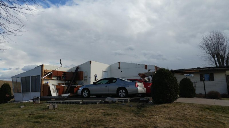
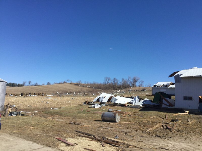
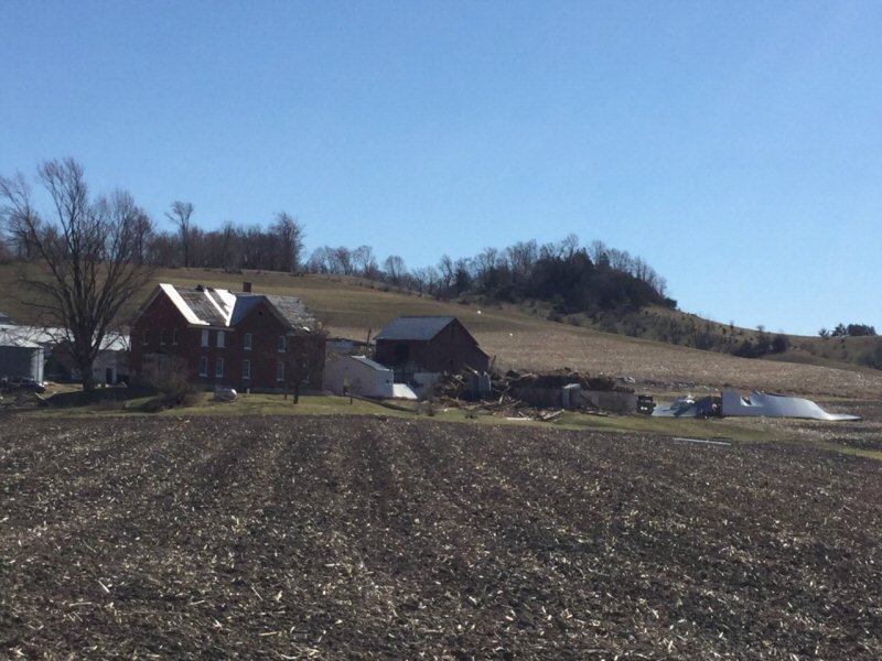
Strong low pressure over the Northern Plains brought unseasonably warm. moist air northward into the region Monday, March 6th, in advance of a strong cold front to the west. Ahead of that front, temperatures warmed through the 50s and 60s in many areas, with even some 70s noted over western portions of Minnesota and Iowa. As that front arrived, it brought with it a line of showers and thunderstorms, some of which were severe with damaging winds of 60 to 70 mph along with hail and frequent lightning. Numerous reports of damage were received across the area. One tornado occurred in La Crosse County. A EF-1 tornado set down about 8:46 p.m. just north of Barre Mills and moved rapidly northeast. The tornado ended just south of West Salem about 8:50 p.m. A broken damage path was found by a NWS Survey Team that estimated the winds topped out between 100 and 110 mph. |
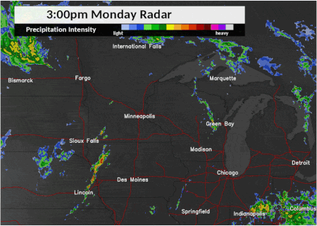 Radar loop of severe thunderstorms as they crossed the area Monday evening. |
Tornadoes:
|
Tornado - West Salem, WI
Track Map 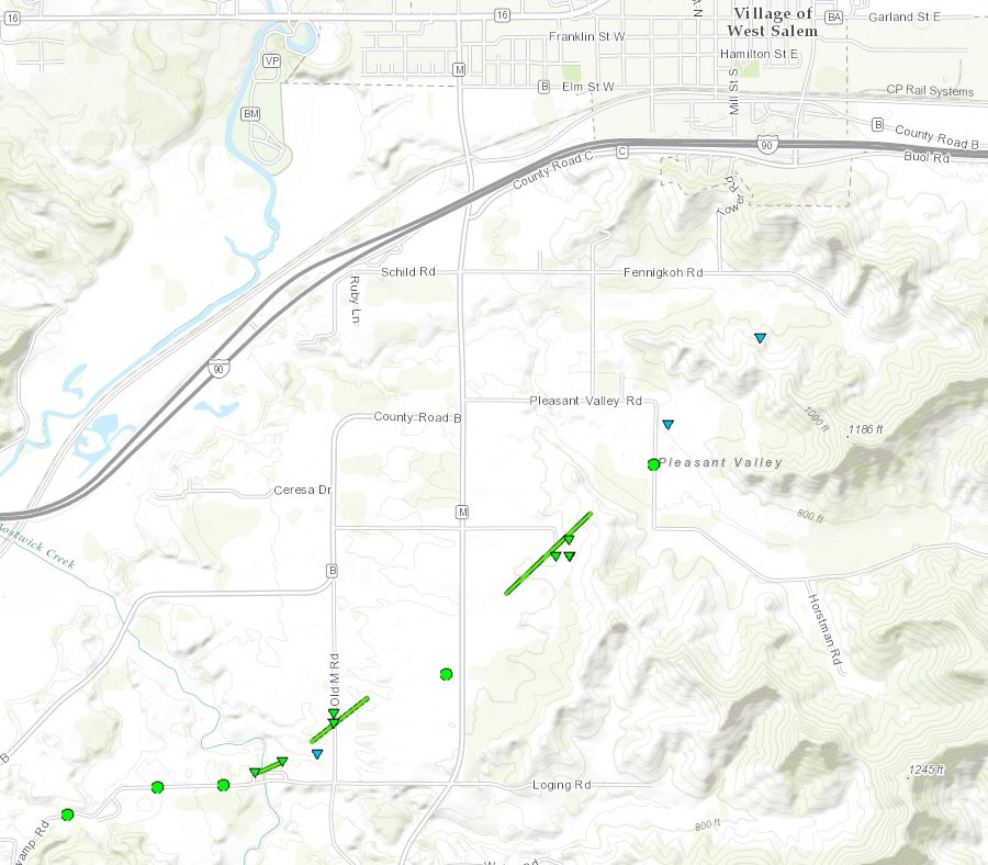 
|
||||||||||||||||
|
||||||||||||||||
The Enhanced Fujita (EF) Scale classifies tornadoes into the following categories:
| EF0 Weak 65-85 mph |
EF1 Moderate 86-110 mph |
EF2 Significant 111-135 mph |
EF3 Severe 136-165 mph |
EF4 Extreme 166-200 mph |
EF5 Catastrophic 200+ mph |
 |
|||||
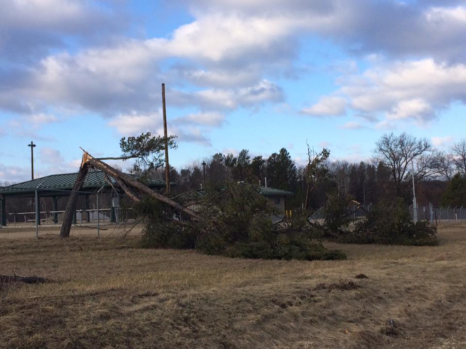
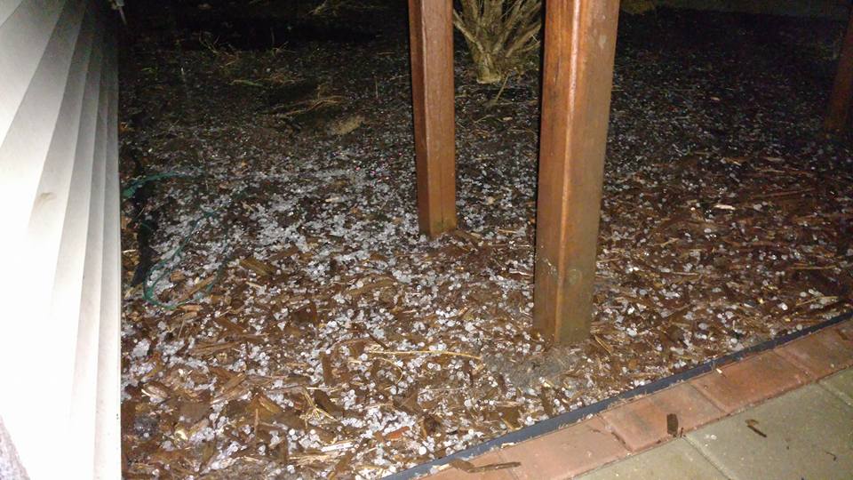
Photos & Video:
Header
 |
 |
 |
 |
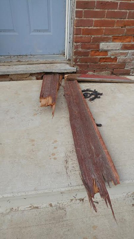
| Tree damage down near Ft McCoy east of Sparta, WI on Highway 16. (Photo by Pat Deethardt) |
Nickle-size hail 3 miles west of St. Joseph, WI (Photo by Tiffany Lawrence) |
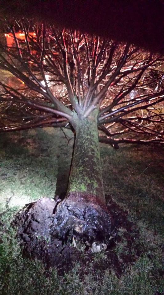
Tree down near Edgewood, IA (Photo by Scott Harris) |
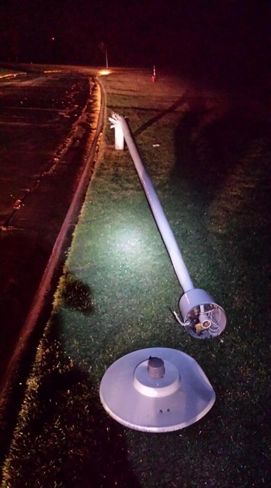
Light post down near Edgewood, IA (Photo by Scott Harris) |
 |
 |
 |
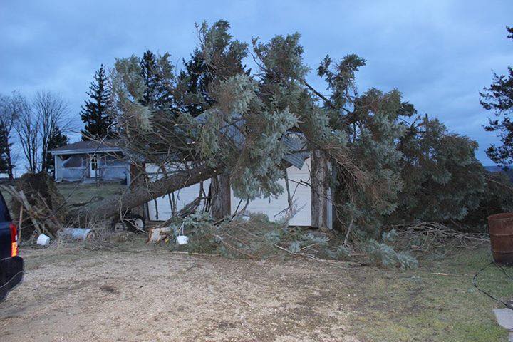 |
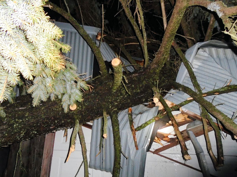
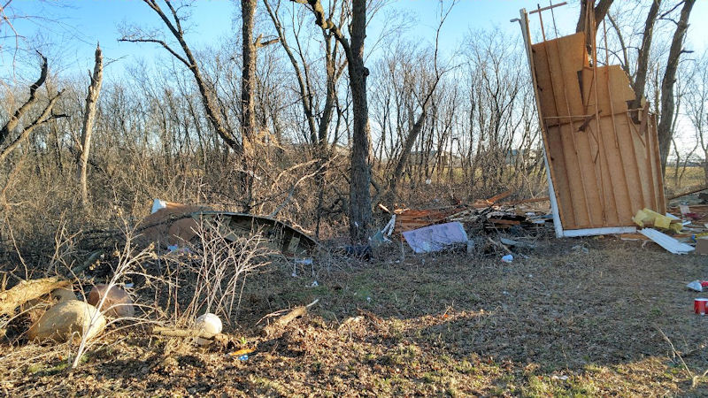
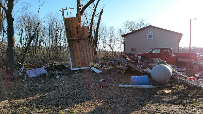
| Damage to a garage 4 miles south of Blue River, WI (Photo by Joshua Parish) |
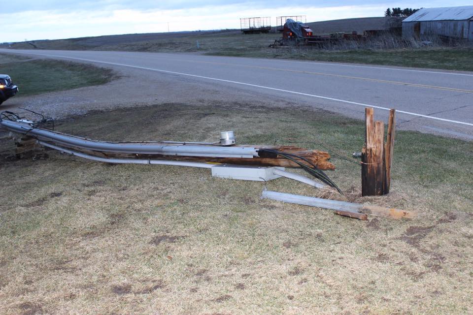
Damage to a light post 4 miles south of Blue River, WI (Photo by Kate Allen) |
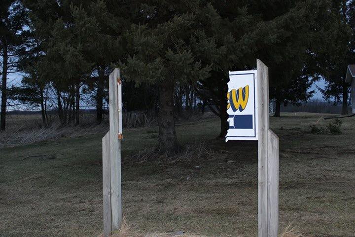
Damage to a sign 4 miles south of Blue River, WI (Photo by Kate Allen) |
Damage to a sign 4 miles south of Blue River, WI (Photo by Kate Allen) |
 |
 |
 |
 |
| Damage just south of Pine Island, MN (Photo courtesy Olmsted County Sheriff's Office) | Damage just south of Pine Island, MN (Photo courtesy Olmsted County Sheriff's Office) | Damage just south of Pine Island, MN (Photo courtesy Olmsted County Sheriff's Office) | Damage just south of Pine Island, MN (Photo courtesy Olmsted County Sheriff's Office) |
Radar:
Below are radar loops of the event, showing the progression of warnings as storms moved through the region.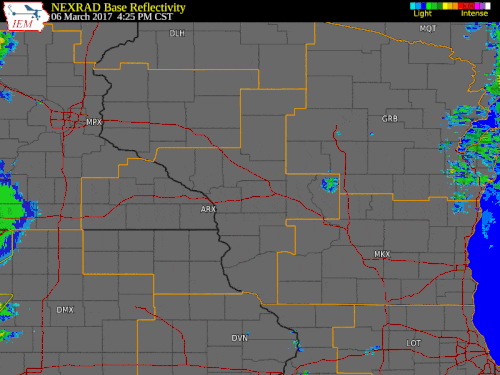 |
| Radar loop with issued warnings |
Storm Reports
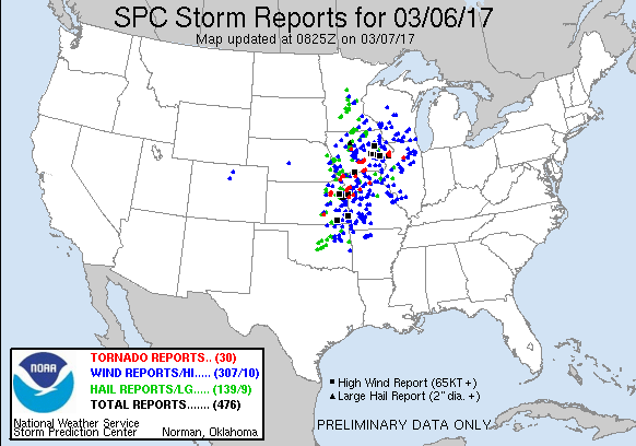 |
| Map showing all the severe weather reports from March 6, 2017 |
PRELIMINARY LOCAL STORM REPORT...SUMMARY
NATIONAL WEATHER SERVICE LA CROSSE WI
1144 AM CST TUE MAR 7 2017
..TIME... ...EVENT... ...CITY LOCATION... ...LAT.LON...
..DATE... ....MAG.... ..COUNTY LOCATION..ST.. ...SOURCE....
..REMARKS..
0606 PM TSTM WND GST 4 W HAYFIELD 43.89N 92.93W
03/06/2017 M45 MPH DODGE MN EMERGENCY MNGR
0606 PM HAIL 1 WSW CLAREMONT 44.04N 93.02W
03/06/2017 E0.25 INCH DODGE MN EMERGENCY MNGR
0611 PM HAIL KASSON 44.03N 92.75W
03/06/2017 E0.25 INCH DODGE MN EMERGENCY MNGR
0611 PM HAIL 1 W HAYFIELD 43.89N 92.87W
03/06/2017 M0.75 INCH DODGE MN EMERGENCY MNGR
0611 PM TSTM WND GST KASSON 44.03N 92.75W
03/06/2017 E60 MPH DODGE MN EMERGENCY MNGR
POWER OUT IN PARTS OF KASSON.
0614 PM HAIL DODGE CENTER 44.03N 92.85W
03/06/2017 E0.25 INCH DODGE MN EMERGENCY MNGR
0626 PM TSTM WND DMG 4 NNW GENOA 44.18N 92.64W
03/06/2017 OLMSTED MN PUBLIC
LARGE TREES BLOWN DOWN AND POLE BUILDING
ROOFS DAMAGED. TIME ESTIMATED BY RADAR.
REPORT VIA TWITTER.
0626 PM TSTM WND DMG 5 NNW GENOA 44.18N 92.64W
03/06/2017 OLMSTED MN PUBLIC
LARGE TREES BLOWN DOWN AND POLE BUILDING
ROOFS DAMAGED. TIME ESTIMATED BY RADAR.
REPORT VIA TWITTER.
0628 PM TSTM WND DMG 2 WNW ORONOCO 44.18N 92.57W
03/06/2017 OLMSTED MN EMERGENCY MNGR
SHED BLOWN ACROSS ROAD AND TOOK OUT SOME
POWER LINES.
0629 PM HAIL 2 SE ORONOCO 44.14N 92.51W
03/06/2017 E0.75 INCH OLMSTED MN EMERGENCY MNGR
0629 PM HAIL ROCHESTER 44.01N 92.48W
03/06/2017 E0.25 INCH OLMSTED MN BROADCAST MEDIA
PEA SIZED HAIL IN NORTHWEST ROCHESTER.
0630 PM TSTM WND DMG 5 NW GENOA 44.17N 92.67W
03/06/2017 OLMSTED MN PUBLIC
REPORTED AT 11144 CR 5 NW, PINE ISLAND, MN.
SMALL PORTION OF ROOF PEALED OFF HOUSE ON SW
CORNER VIA EAVES. DOWNED PINE TREE. .
0640 PM TSTM WND GST 2 WNW ORONOCO 44.18N 92.57W
03/06/2017 M56 MPH OLMSTED MN TRAINED SPOTTER
TWO PINE TREES OF ONE FOOT IN DIAMETER BLOWN
DOWN.
0649 PM TSTM WND GST 1 S NORA SPRINGS 43.13N 93.01W
03/06/2017 E60 MPH FLOYD IA FIRE DEPT/RESCUE
NORA SPRING FD.
0651 PM HAIL 1 S NORA SPRINGS 43.13N 93.01W
03/06/2017 E1.00 INCH FLOYD IA FIRE DEPT/RESCUE
NORA SPRING FD.
0652 PM TSTM WND DMG RUDD 43.13N 92.90W
03/06/2017 FLOYD IA 911 CALL CENTER
POWER LINES DOWN IN MANY AREAS OF COUNTY.
0652 PM HAIL RUDD 43.13N 92.90W
03/06/2017 E1.00 INCH FLOYD IA 911 CALL CENTER
0652 PM HAIL 1 W MARBLE ROCK 42.96N 92.89W
03/06/2017 E0.88 INCH FLOYD IA FIRE DEPT/RESCUE
NORA SPRING FD.
0659 PM HAIL 4 ESE ROCKFORD 43.04N 92.87W
03/06/2017 M0.75 INCH FLOYD IA FIRE DEPT/RESCUE
.
0700 PM HAIL SAINT ANSGAR 43.38N 92.92W
03/06/2017 E0.25 INCH MITCHELL IA TRAINED SPOTTER
0701 PM HAIL 4 NW FLOYD 43.17N 92.80W
03/06/2017 M1.00 INCH FLOYD IA FIRE DEPT/RESCUE
FLOYD FD.
0705 PM TSTM WND GST COLWELL 43.16N 92.59W
03/06/2017 M48 MPH FLOYD IA TRAINED SPOTTER
0705 PM HAIL COLWELL 43.16N 92.59W
03/06/2017 M0.75 INCH FLOYD IA TRAINED SPOTTER
0705 PM TSTM WND DMG DAVIS CORNERS 43.36N 92.30W
03/06/2017 HOWARD IA EMERGENCY MNGR
EMERGENCY MANAGER REPORTED TWO BUILDINGS
DAMAGED AND A COUPLE OF TREES BLOWN DOWN.
TIME ESTIMATED BY RADAR.
0705 PM HAIL FLOYD 43.13N 92.74W
03/06/2017 E1.00 INCH FLOYD IA LAW ENFORCEMENT
0712 PM HAIL LE ROY 43.51N 92.51W
03/06/2017 E0.75 INCH MOWER MN LAW ENFORCEMENT
0715 PM HAIL 1 W LITTLE CEDAR 43.38N 92.74W
03/06/2017 E1.00 INCH MITCHELL IA EMERGENCY MNGR
0715 PM HAIL 1 SSE RICEVILLE 43.35N 92.55W
03/06/2017 E0.88 INCH HOWARD IA EMERGENCY MNGR
0715 PM HAIL RICEVILLE 43.36N 92.55W
03/06/2017 E1.00 INCH HOWARD IA EMERGENCY MNGR
0725 PM HAIL 5 ESE NEW HAVEN 43.25N 92.55W
03/06/2017 E1.00 INCH HOWARD IA PUBLIC
0730 PM HAIL 1 SSE CHERRY GROVE 43.57N 92.28W
03/06/2017 E0.50 INCH FILLMORE MN TRAINED SPOTTER
0730 PM TSTM WND DMG 1 SSE CHERRY GROVE 43.57N 92.28W
03/06/2017 FILLMORE MN TRAINED SPOTTER
SMALL BRANCHES DOWN.
0735 PM TSTM WND GST 5 ENE RACINE 43.79N 92.39W
03/06/2017 E50 MPH FILLMORE MN AMATEUR RADIO
0740 PM TSTM WND DMG 1 SW MONDOVI 44.56N 91.69W
03/06/2017 BUFFALO WI LAW ENFORCEMENT
TREE REPORTED DOWN SOUTH OF MONDOVI ALONG
HWY 37. TIME ESTIMATED FROM RADAR. .
0743 PM TSTM WND GST 1 S GREENLEAFTON 43.56N 92.21W
03/06/2017 E45 MPH FILLMORE MN AMATEUR RADIO
0743 PM HAIL 1 S GREENLEAFTON 43.56N 92.21W
03/06/2017 E0.50 INCH FILLMORE MN AMATEUR RADIO
0744 PM HAIL CRESCO 43.37N 92.12W
03/06/2017 E0.50 INCH HOWARD IA PUBLIC
TORRENTIAL RAINS, 30 TO 40 MPH WIND.
0744 PM HAIL LEWISTON 43.98N 91.87W
03/06/2017 E0.75 INCH WINONA MN LAW ENFORCEMENT
STRONG WINDS AND TORENTIAL RAIN.
0747 PM HAIL HARMONY 43.56N 92.01W
03/06/2017 E0.25 INCH FILLMORE MN LAW ENFORCEMENT
HAIL COVERING GROUND.
0747 PM TSTM WND GST HARMONY 43.56N 92.01W
03/06/2017 M56 MPH FILLMORE MN LAW ENFORCEMENT
0752 PM HAIL 1 WSW WHALAN 43.73N 91.94W
03/06/2017 M0.88 INCH FILLMORE MN CO-OP OBSERVER
TIME ESTIMATED FROM RADAR.
0812 PM TSTM WND DMG WINONA 44.05N 91.66W
03/06/2017 WINONA MN PUBLIC
LARGE TREE BLOWN DOWN ON A CAR AND PARTIALLY
ON A HOUSE. REPORT VIA FACEBOOK.
0818 PM TSTM WND DMG ELK CREEK 44.43N 91.40W
03/06/2017 TREMPEALEAU WI PUBLIC
METAL GRAIN BIN BLOWN OVER. TIME ESTIMATED
FROM RADAR. REPORT VIA TWITTER.
0830 PM HAIL 2 ENE MOUND PRAIRIE 43.80N 91.41W
03/06/2017 E0.25 INCH HOUSTON MN CO-OP OBSERVER
WIND GUST TO 29 MPH.
0831 PM TSTM WND DMG 3 SE HOKAH 43.73N 91.32W
03/06/2017 HOUSTON MN PUBLIC
SEVERAL LARGE PINE TREES SNAPPED. TWO
OUTBUILDINGS DESTROYED WITH OTHERS DAMAGED.
TIME ESTIMATED FROM RADAR. REPORT VIA
FACEBOOK.
0833 PM TSTM WND DMG BROWNSVILLE 43.70N 91.28W
03/06/2017 HOUSTON MN PUBLIC
ROOF PARTIALLY BLOWN OFF A BARN. TIME
ESTIMATED FROM RADAR. REPORT VIA TWITTER.
0836 PM HAIL 1 SW LA CROSSE 43.81N 91.25W
03/06/2017 E0.25 INCH LA CROSSE WI BROADCAST MEDIA
0836 PM TSTM WND GST 1 NE LA CRESCENT 43.83N 91.30W
03/06/2017 E50 MPH HOUSTON MN NWS EMPLOYEE
TRAMPOLINE BLOWN ACROSS YARD.
0836 PM TSTM WND GST 1 SW LA CROSSE 43.81N 91.25W
03/06/2017 E50 MPH LA CROSSE WI BROADCAST MEDIA
0836 PM HAIL 1 NE LA CRESCENT 43.83N 91.30W
03/06/2017 E0.25 INCH HOUSTON MN NWS EMPLOYEE
0836 PM TSTM WND DMG STODDARD 43.66N 91.22W
03/06/2017 VERNON WI AMATEUR RADIO
POWER LINES DOWN EAST OF STODDARD.
0840 PM TSTM WND GST 2 WNW FRENCH ISLAND 43.87N 91.30W
03/06/2017 E60 MPH LA CROSSE WI TRAINED SPOTTER
PEA SIZE HAIL ALSO.
0841 PM TSTM WND DMG 1 SW LA CROSSE 43.81N 91.25W
03/06/2017 LA CROSSE WI PUBLIC
LIGHT POST AND BUSINESS SIGN BLOWN DOWN IN
DOWNTOWN LA CROSSE. TIME ESTIMATED FROM
RADAR.
0842 PM HAIL 1 ENE LA CROSSE 43.83N 91.22W
03/06/2017 E0.25 INCH LA CROSSE WI NWS EMPLOYEE
AT NATIONAL WEATHER SERVICE LA CROSSE
OFFICE.
0842 PM TSTM WND GST 1 ENE LA CROSSE 43.83N 91.22W
03/06/2017 M50 MPH LA CROSSE WI NWS EMPLOYEE
AT NATIONAL WEATHER SERVICE LA CROSSE
OFFICE.
0842 PM TSTM WND GST 1 NNE FRENCH ISLAND 43.88N 91.26W
03/06/2017 M53 MPH LA CROSSE WI ASOS
ASOS STATION LA CROSSE REGIONAL AIRPORT
/LSE/.
0845 PM TSTM WND DMG CHASEBURG 43.66N 91.09W
03/06/2017 VERNON WI LAW ENFORCEMENT
POWER LINES/OUTAGES REPORTED IN CHASEBURG. .
0845 PM HEAVY RAIN 4 N ELBA 44.15N 92.00W
03/06/2017 M0.59 INCH WINONA MN CO-OP OBSERVER
CO-OP OBSERVER STATION 4 NNE ELBA /BVRM5R2/.
0850 PM TSTM WND DMG 1 SSW LA CROSSE 43.82N 91.24W
03/06/2017 LA CROSSE WI NWS EMPLOYEE
DOZEN OR SO 1-2 FT DIAMETER SPRUCE AND WHITE
PINES UPROOTED/DOWNED IN OAK GROVE CEMETARY
AND MYRICK PARK. TIME APPROXIMATE.
0852 PM TSTM WND DMG MONONA 43.05N 91.39W
03/06/2017 CLAYTON IA LAW ENFORCEMENT
SHINGLES BLOWN OFF HOUSE.
0855 PM HAIL WEST SALEM 43.90N 91.08W
03/06/2017 M0.25 INCH LA CROSSE WI PUBLIC
UP TO 3/8 INCH IN DIAMETER.
0856 PM TSTM WND GST 2 ENE EDGEWOOD 42.65N 91.37W
03/06/2017 M46 MPH CLAYTON IA CO-OP OBSERVER
0857 PM TSTM WND DMG 4 W VIROQUA 43.56N 90.97W
03/06/2017 VERNON WI LAW ENFORCEMENT
FALLEN TREES DAMAGED CAMPER WEST OF VIROQUA
ALONG HIGHWAY 56. TIME/LOCATION ESTIMATED. .
0900 PM TSTM WND GST 3 ENE WESTBY 43.67N 90.81W
03/06/2017 M52 MPH VERNON WI CO-OP OBSERVER
.
0900 PM HAIL 2 W SAINT JOSEPH 43.79N 91.09W
03/06/2017 E0.88 INCH LA CROSSE WI NWS EMPLOYEE
0900 PM HEAVY RAIN 5 SW ELBA 44.04N 92.09W
03/06/2017 M0.53 INCH OLMSTED MN COCORAHS
COCORAHS STATION ELBA 4.7 SW /MN-OL-991/.
0900 PM HEAVY RAIN 1 E DOVER 43.97N 92.12W
03/06/2017 M0.50 INCH OLMSTED MN MESONET
MESONET STATION DOVER /DVRM5/.
0900 PM TSTM WND GST 2 W SAINT JOSEPH 43.79N 91.09W
03/06/2017 M60 MPH LA CROSSE WI NWS EMPLOYEE
0900 PM HEAVY RAIN 1 N KELLOGG 44.32N 92.00W
03/06/2017 M1.10 INCH WABASHA MN CO-OP OBSERVER
CO-OP OBSERVER STATION KELLOGG-ZUMBRO RIVER
/KELM5/.
0900 PM HEAVY RAIN 5 WSW ROCHESTER 43.98N 92.56W
03/06/2017 M1.16 INCH OLMSTED MN MESONET
MESONET STATION 4 WSW ROCHESTER /SFZM5/.
0900 PM TSTM WND GST 3 ENE WESTBY 43.67N 90.81W
03/06/2017 M52 MPH VERNON WI CO-OP OBSERVER
.
0900 PM HEAVY RAIN 2 S AUSTIN 43.64N 92.97W
03/06/2017 M0.51 INCH MOWER MN MESONET
MESONET STATION AUSTIN 3S /ASNM5/.
0903 PM HAIL SPARTA 43.94N 90.81W
03/06/2017 E0.25 INCH MONROE WI AMATEUR RADIO
0904 PM TSTM WND DMG EDGEWOOD 42.64N 91.40W
03/06/2017 CLAYTON IA TRAINED SPOTTER
LIGHT POST AND 12 INCH DIAMETER TREE BLOWN
DOWN. TIME ESTIMATED FROM RADAR.
0904 PM TSTM WND DMG VIROQUA 43.56N 90.89W
03/06/2017 VERNON WI LAW ENFORCEMENT
TREES, INCLUDING SEVERAL PINES, DOWN IN AND
NEAR VIROQUA WITH SEVERAL POWER LINES DOWN.
TIME ESTIMATED FROM RADAR. .
0904 PM TSTM WND GST EDGEWOOD 42.64N 91.40W
03/06/2017 E73 MPH CLAYTON IA FIRE DEPT/RESCUE
.
0905 PM TSTM WND DMG 2 E WEST SALEM 43.90N 91.04W
03/06/2017 LA CROSSE WI TRAINED SPOTTER
6 TO 9 INCH DIAMETER TREE BLOWN DOWN AND
BLOCKING RIGHT EAST BOUND LANE OF INTERSTATE
90.
0907 PM TSTM WND GST ELKADER 42.86N 91.40W
03/06/2017 M73 MPH CLAYTON IA LAW ENFORCEMENT
0915 PM TSTM WND GST 2 NNW VIROQUA 43.58N 90.90W
03/06/2017 M47 MPH VERNON WI AWOS
AWOS STATION VIROQUA MUNICIPAL AIRPORT
/Y51/.
0915 PM TSTM WND GST 4 ENE SPARTA 43.96N 90.74W
03/06/2017 M46 MPH MONROE WI AWOS
AWOS STATION SPARTA/FORT MCCOY AIRPORT
/CMY/.
0920 PM TSTM WND GST TOMAH 43.99N 90.50W
03/06/2017 E45 MPH MONROE WI AMATEUR RADIO
0920 PM HEAVY RAIN 2 ENE EDGEWOOD 42.65N 91.37W
03/06/2017 M0.80 INCH CLAYTON IA CO-OP OBSERVER
0925 PM HAIL LA FARGE 43.58N 90.64W
03/06/2017 E1.25 INCH VERNON WI FIRE DEPT/RESCUE
0925 PM TSTM WND GST LA FARGE 43.58N 90.64W
03/06/2017 E60 MPH VERNON WI FIRE DEPT/RESCUE
ESTIMATED 50 TO 60 MPH WIND GUST.
0929 PM HAIL 1 N CAMP DOUGLAS 43.93N 90.27W
03/06/2017 M0.25 INCH JUNEAU WI ASOS
KVOK ASOS.
0930 PM HEAVY RAIN 2 SSW AUSTIN 43.65N 92.98W
03/06/2017 M0.69 INCH MOWER MN CO-OP OBSERVER
CO-OP OBSERVER STATION AUSTIN 3 NW - TURTLE
CREEK /TRCM5/.
0930 PM HEAVY RAIN CHARLES CITY 43.06N 92.67W
03/06/2017 M0.77 INCH FLOYD IA MESONET
MESONET STATION CHARLES CITY-CEDAR RIVER
/CCYI4/.
0930 PM HEAVY RAIN 1 ENE LANSING 43.75N 92.95W
03/06/2017 M0.76 INCH MOWER MN CO-OP OBSERVER
CO-OP OBSERVER STATION LANSING-CEDAR RIVER
/LANM5/.
0932 PM TSTM WND GST 2 NNE CAMP DOUGLAS 43.94N 90.25W
03/06/2017 M63 MPH JUNEAU WI ASOS
ASOS STATION VOLK FIELD /VOK/.
0933 PM TSTM WND DMG DORCHESTER 45.00N 90.33W
03/06/2017 CLARK WI LAW ENFORCEMENT
POWERLINES DOWN WEST OF HIGHWAY 13. TIME
ESTIMATED FROM RADAR.
0937 PM TSTM WND GST 1 N CAMP DOUGLAS 43.93N 90.27W
03/06/2017 M54 MPH JUNEAU WI ASOS
KVOK ASOS.
0937 PM TSTM WND GST 2 NNE CAMP DOUGLAS 43.94N 90.25W
03/06/2017 M54 MPH JUNEAU WI ASOS
ASOS STATION VOLK FIELD /VOK/.
0939 PM HEAVY RAIN 1 NNE BYRON 44.04N 92.64W
03/06/2017 M0.68 INCH OLMSTED MN MESONET
MESONET STATION BYRON /E5820/.
0940 PM HEAVY RAIN 2 SSE DOUGLAS 44.08N 92.55W
03/06/2017 M0.59 INCH OLMSTED MN MESONET
MESONET STATION 2 SE DOUGLAS /D7310/.
0945 PM TSTM WND GST 3 NE MOUNT HOPE 43.00N 90.82W
03/06/2017 E55 MPH GRANT WI TRAINED SPOTTER
2 TO 3 INCH DIAMETER TREE LIMBS DOWN.
0945 PM HEAVY RAIN 1 WSW ELBA 44.09N 92.03W
03/06/2017 M0.51 INCH WINONA MN CO-OP OBSERVER
CO-OP OBSERVER STATION ELBA /EBWM5/.
0945 PM HEAVY RAIN 2 SSE BASSETT 43.03N 92.50W
03/06/2017 M0.64 INCH CHICKASAW IA CO-OP OBSERVER
CO-OP OBSERVER STATION IONIA 2W /IONI4/.
0945 PM TSTM WND DMG NECEDAH 44.03N 90.07W
03/06/2017 JUNEAU WI LAW ENFORCEMENT
TREES REPORTED DOWN AT VARIOUS LOCATIONS IN
JUNEAU COUNTY. TIME ESTIMATED FROM RADAR. .
0945 PM HAIL DORCHESTER 45.00N 90.33W
03/06/2017 E0.25 INCH CLARK WI TRAINED SPOTTER
0945 PM TSTM WND GST 2 NE BOSCOBEL 43.16N 90.67W
03/06/2017 M49 MPH GRANT WI ASOS
ASOS STATION BOSCOBEL AIRPORT /OVS/.
0945 PM TSTM WND DMG 4 S BLUE RIVER 43.13N 90.57W
03/06/2017 GRANT WI PUBLIC
REPORT VIA TWITTER SHOWING WIND DAMAGE TO
SEVERAL STRUCTURES. TIME ESTIMATED FROM
RADAR.
0948 PM HAIL NECEDAH 44.02N 90.07W
03/06/2017 E0.25 INCH JUNEAU WI 911 CALL CENTER
0948 PM HEAVY RAIN 1 WSW ROCHESTER 44.01N 92.49W
03/06/2017 M1.20 INCH OLMSTED MN MESONET
MESONET STATION ROCHESTER /C8544/.
0950 PM HEAVY RAIN 4 ESE DOUGLAS 44.09N 92.51W
03/06/2017 M0.88 INCH OLMSTED MN MESONET
MESONET STATION 3 ESE DOUGLAS /AU624/.
0950 PM TSTM WND DMG HILLSBORO 43.66N 90.34W
03/06/2017 VERNON WI LAW ENFORCEMENT
TREES AND POWER LINES DOWN IN HILLSBORO.
0955 PM HEAVY RAIN 3 NNE ROCHESTER 44.05N 92.45W
03/06/2017 M1.18 INCH OLMSTED MN MESONET
MESONET STATION 3 NE ROCHESTER /E4643/.
0955 PM HEAVY RAIN SAINT ANSGAR 43.38N 92.92W
03/06/2017 M0.50 INCH MITCHELL IA MESONET
MESONET STATION SAINT ANSGAR /C1238/.
0956 PM TSTM WND GST 2 ENE PORT ANDREW 43.22N 90.53W
03/06/2017 M49 MPH RICHLAND WI AMATEUR RADIO
.
1000 PM HEAVY RAIN WABASHA 44.37N 92.05W
03/06/2017 M1.50 INCH WABASHA MN PUBLIC
.
1021 PM TSTM WND GST PLATTEVILLE 42.74N 90.48W
03/06/2017 E55 MPH GRANT WI TRAINED SPOTTER
ESTIMATED 50 TO 55 MPH GUST.
1024 PM HAIL HAZEL GREEN 42.53N 90.44W
03/06/2017 E0.75 INCH GRANT WI FIRE DEPT/RESCUE
1028 PM TSTM WND DMG 2 ENE WHITE CREEK 43.83N 89.82W
03/06/2017 ADAMS WI LAW ENFORCEMENT
SPORADIC TREES REPORTED DOWN ACROSS ADAMS
COUNTY, INCLUDING ROME, STRONGS PRAIRIE, AND
SPRINGVILLE TOWNSHIPS. TIME ESTIMATED FROM
RADAR. .
0230 AM HEAVY RAIN 1 SW ORONOCO 44.16N 92.54W
03/07/2017 M0.50 INCH OLMSTED MN CO-OP OBSERVER
CO-OP OBSERVER STATION ORONOCO /OCOM5/.
0428 AM HEAVY RAIN KENDALL 43.79N 90.37W
03/07/2017 M0.60 INCH MONROE WI TRAINED SPOTTER
.
0552 AM HEAVY RAIN ROCHESTER 44.02N 92.48W
03/07/2017 M1.00 INCH OLMSTED MN AWOS
AWOS STATION MAYO HELIPAD /9MN/.
0554 AM HEAVY RAIN 4 N STEWARTVILLE 43.91N 92.50W
03/07/2017 M0.91 INCH OLMSTED MN ASOS
ASOS STATION ROCHESTER INTERNATIONAL AIRPORT
/RST/.
0555 AM HEAVY RAIN 3 E CHARLES CITY 43.07N 92.61W
03/07/2017 M0.65 INCH FLOYD IA AWOS
AWOS STATION CHARLES CITY AIRPORT /CCY/.
0558 AM HEAVY RAIN 2 NNE CAMP DOUGLAS 43.94N 90.25W
03/07/2017 M0.52 INCH JUNEAU WI ASOS
ASOS STATION VOLK FIELD /VOK/.
0600 AM HEAVY RAIN ALMA 44.33N 91.92W
03/07/2017 M0.81 INCH BUFFALO WI CO-OP OBSERVER
CO-OP OBSERVER STATION ALMA DAM 4 /ALMW3/.
0600 AM HEAVY RAIN GENOA 43.57N 91.23W
03/07/2017 M0.68 INCH VERNON WI CO-OP OBSERVER
CO-OP OBSERVER STATION GENOA DAM 8 /GENW3/.
0600 AM HEAVY RAIN 3 NE ROCHESTER 44.04N 92.44W
03/07/2017 M1.53 INCH OLMSTED MN COCORAHS
COCORAHS STATION 2 NE ROCHESTER /MN-OL-18/.
0600 AM HEAVY RAIN GRAND MEADOW 43.71N 92.56W
03/07/2017 M0.60 INCH MOWER MN CO-OP OBSERVER
CO-OP OBSERVER STATION GRAND MEADOW /GMDM5/.
0600 AM HEAVY RAIN 1 ESE GUTTENBERG 42.78N 91.10W
03/07/2017 M0.76 INCH CLAYTON IA CO-OP OBSERVER
CO-OP OBSERVER STATION GUTTENBERG DAM 10
/GTTI4/.
0600 AM HEAVY RAIN 5 NW EASTMAN 43.21N 91.10W
03/07/2017 M0.55 INCH CRAWFORD WI CO-OP OBSERVER
CO-OP OBSERVER STATION LYNXVILLE DAM 9
/LYNW3/.
0630 AM HEAVY RAIN SAINT ANSGAR 43.38N 92.92W
03/07/2017 M0.55 INCH MITCHELL IA CO-OP OBSERVER
CO-OP OBSERVER STATION ST ANSGAR /SANI4/.
0700 AM HEAVY RAIN LA FARGE 43.57N 90.64W
03/07/2017 M0.52 INCH VERNON WI CO-OP OBSERVER
CO-OP OBSERVER STATION LA FARGE /LAFW3/.
0700 AM HEAVY RAIN 1 S AUSTIN 43.65N 92.97W
03/07/2017 M0.71 INCH MOWER MN CO-OP OBSERVER
CO-OP OBSERVER STATION AUSTIN WASTE WATER
TREATMENT FACILITY /ASTM5/.
0700 AM HEAVY RAIN NEW HAMPTON 43.06N 92.32W
03/07/2017 M0.60 INCH CHICKASAW IA COCORAHS
COCORAHS STATION NEW HAMPTON /IA-CW-3/.
0700 AM HEAVY RAIN 1 E VIROQUA 43.56N 90.88W
03/07/2017 M0.62 INCH VERNON WI CO-OP OBSERVER
CO-OP OBSERVER STATION VIROQUA /VQAW3/.
0700 AM HEAVY RAIN 1 ENE ALPHA 43.01N 92.03W
03/07/2017 M0.63 INCH FAYETTE IA COCORAHS
COCORAHS STATION 1 ENE ALPHA /IA-FY-3/.
0700 AM HEAVY RAIN 1 N WABASHA 44.38N 92.05W
03/07/2017 M0.94 INCH WABASHA MN CO-OP OBSERVER
CO-OP OBSERVER STATION WABASHA /WABM5/.
0700 AM HEAVY RAIN 1 NNW SPRING VALLEY 43.69N 92.39W
03/07/2017 M0.51 INCH FILLMORE MN CO-OP OBSERVER
CO-OP OBSERVER STATION SPRING VALLEY
/SPGM5/.
0700 AM HEAVY RAIN 1 S DE SOTO 43.42N 91.19W
03/07/2017 M0.72 INCH CRAWFORD WI CO-OP OBSERVER
CO-OP OBSERVER STATION DE SOTO 1SE /VICW3/.
0700 AM HEAVY RAIN 1 SSE CHARLES CITY 43.06N 92.67W
03/07/2017 M0.93 INCH FLOYD IA CO-OP OBSERVER
CO-OP OBSERVER STATION CHARLES CITY /CIYI4/.
0700 AM HEAVY RAIN 2 N VIOLA 44.10N 92.27W
03/07/2017 M0.85 INCH OLMSTED MN CO-OP OBSERVER
CO-OP OBSERVER STATION ELGIN 2SSW /EGNM5/.
0700 AM HEAVY RAIN 3 NNW ROCHESTER 44.05N 92.49W
03/07/2017 M1.25 INCH OLMSTED MN COCORAHS
COCORAHS STATION 2 NNW ROCHESTER /MN-OL-32/.
0700 AM HEAVY RAIN 2 SW GENOA 44.09N 92.64W
03/07/2017 M0.51 INCH OLMSTED MN CO-OP OBSERVER
CO-OP OBSERVER STATION BYRON 4 NORTH
/BYRM5/.
0700 AM HEAVY RAIN 5 N STEWARTVILLE 43.93N 92.48W
03/07/2017 M1.03 INCH OLMSTED MN CO-OP OBSERVER
CO-OP OBSERVER STATION ROCHESTER AP 2NE
/RSRM5/.
0700 AM HEAVY RAIN NEW HAMPTON 43.06N 92.32W
03/07/2017 M0.52 INCH CHICKASAW IA COCORAHS
COCORAHS STATION NEW HAMPTON /IA-CW-2/.
0700 AM HEAVY RAIN 4 SE MINNEISKA 44.16N 91.81W
03/07/2017 M0.50 INCH WINONA MN CO-OP OBSERVER
CO-OP OBSERVER STATION MINNESOTA CITY DAM 5
/MSCM5/.
0700 AM HEAVY RAIN 2 WSW HILLSBORO 43.63N 90.38W
03/07/2017 M0.57 INCH VERNON WI CO-OP OBSERVER
CO-OP OBSERVER STATION HILLSBORO 2SW
/HLBW3/.
0700 AM HEAVY RAIN 1 WNW OELWEIN 42.68N 91.93W
03/07/2017 M0.59 INCH FAYETTE IA COCORAHS
COCORAHS STATION OELWEIN /IA-FY-2/.
0700 AM HEAVY RAIN 1 ESE VIROQUA 43.55N 90.87W
03/07/2017 M0.55 INCH VERNON WI COCORAHS
COCORAHS STATION VIROQUA 0.8 ESE /WI-VR-2/.
0700 AM HEAVY RAIN 2 SSE NORA SPRINGS 43.11N 92.99W
03/07/2017 M0.68 INCH FLOYD IA COCORAHS
COCORAHS STATION NORA SPRINGS 2.4 SSE
/IA-FL-3/.
0700 AM HEAVY RAIN NEW HAMPTON 43.06N 92.31W
03/07/2017 M0.50 INCH CHICKASAW IA CO-OP OBSERVER
CO-OP OBSERVER STATION NEW HAMPTON /NHPI4/.
0700 AM HEAVY RAIN 3 ENE WESTBY 43.67N 90.81W
03/07/2017 M0.64 INCH VERNON WI CO-OP OBSERVER
CO-OP OBSERVER STATION WESTBY 3ENE /WESW3/.
0700 AM HEAVY RAIN 1 NW FAYETTE 42.85N 91.82W
03/07/2017 M0.63 INCH FAYETTE IA CO-OP OBSERVER
CO-OP OBSERVER STATION FAYETTE /FYTI4/.
0715 AM HEAVY RAIN 1 W OELWEIN 42.68N 91.93W
03/07/2017 M0.59 INCH FAYETTE IA TRAINED SPOTTER
.
0800 AM HEAVY RAIN 1 SSW THEILMAN 44.28N 92.19W
03/07/2017 M1.30 INCH WABASHA MN CO-OP OBSERVER
CO-OP OBSERVER STATION THEILMAN 1SSW
/THLM5/.
0800 AM HEAVY RAIN 4 WNW VIOLA 43.53N 90.74W
03/07/2017 M0.62 INCH VERNON WI COCORAHS
COCORAHS STATION 3 WNW VIOLA /WI-VR-3/.
0815 AM HEAVY RAIN 3 N ROCHESTER 44.06N 92.47W
03/07/2017 M1.16 INCH OLMSTED MN MESONET
MESONET STATION 3 N ROCHESTER /RCHM5/.
0815 AM HEAVY RAIN GARBER 42.74N 91.26W
03/07/2017 M0.58 INCH CLAYTON IA MESONET
MESONET STATION GARBER /GRBI4/.
0815 AM HEAVY RAIN DAKOTA 43.91N 91.36W
03/07/2017 M0.50 INCH WINONA MN MESONET
MESONET STATION DAKOTA /DKTM5/.
0830 AM HEAVY RAIN 3 NNE DOVER 44.01N 92.11W
03/07/2017 M0.58 INCH OLMSTED MN CO-OP OBSERVER
CO-OP OBSERVER STATION ELGIN 5SE /WFOM5/.
0830 AM HEAVY RAIN 3 ENE ROCHESTER 44.03N 92.43W
03/07/2017 M1.37 INCH OLMSTED MN MESONET
MESONET STATION 2 ENE ROCHESTER /ROCM5/.
0830 AM HEAVY RAIN 2 ESE ROCHESTER 44.01N 92.45W
03/07/2017 M1.35 INCH OLMSTED MN CO-OP OBSERVER
CO-OP OBSERVER STATION ROCHESTER-BELTLINE
BEAR CREEK /RBCM5/.
0830 AM HEAVY RAIN 1 N ROCHESTER 44.03N 92.47W
03/07/2017 M1.28 INCH OLMSTED MN CO-OP OBSERVER
CO-OP OBSERVER STATION ROCHESTER-CASCADE
CREEK /RCCM5/.
0830 AM HEAVY RAIN 1 ESE AUSTIN 43.67N 92.95W
03/07/2017 M0.69 INCH MOWER MN CO-OP OBSERVER
CO-OP OBSERVER STATION AUSTIN 2NE-DOBBINS
CREEK /DOBM5/.
0830 AM HEAVY RAIN 3 W ROCHESTER 44.02N 92.53W
03/07/2017 M1.10 INCH OLMSTED MN CO-OP OBSERVER
CO-OP OBSERVER STATION ROCHESTER 3W /RCRM5/.
0830 AM HEAVY RAIN ROCHESTER 44.01N 92.47W
03/07/2017 M1.48 INCH OLMSTED MN MESONET
MESONET STATION ROCHESTER-BELTLINE /RCSM5/.
0830 AM HEAVY RAIN 2 NE EYOTA 44.01N 92.20W
03/07/2017 M0.80 INCH OLMSTED MN CO-OP OBSERVER
CO-OP OBSERVER STATION EYOTA 2NE /WIRM5/.
0830 AM HEAVY RAIN 3 SW ELBA 44.06N 92.05W
03/07/2017 M0.55 INCH WINONA MN CO-OP OBSERVER
CO-OP OBSERVER STATION WHITEWATER STATE PARK
GROUP CAMP /WWPM5/.
0833 AM HEAVY RAIN 8 ENE DECORAH 43.34N 91.64W
03/07/2017 M0.53 INCH WINNESHIEK IA COCORAHS
COCORAHS STATION 7 ENE DECORAH /IA-WH-1/.
0845 AM HEAVY RAIN 1 NNE HOUSTON 43.77N 91.57W
03/07/2017 M0.82 INCH HOUSTON MN MESONET
MESONET STATION HOUSTON /HOUM5/.
0848 AM HEAVY RAIN 1 WNW NECEDAH 44.03N 90.08W
03/07/2017 M0.61 INCH JUNEAU WI MESONET
MESONET STATION NECEDAH /NEHW3/.
0854 AM HEAVY RAIN 4 ESE DOUGLAS 44.09N 92.49W
03/07/2017 M0.88 INCH OLMSTED MN MESONET
MESONET STATION 4 ESE DOUGLAS /AU801/.
0858 AM HEAVY RAIN 1 NNE BYRON 44.04N 92.64W
03/07/2017 M0.70 INCH OLMSTED MN MESONET
MESONET STATION BYRON /E5820/.
0858 AM HEAVY RAIN 2 SSE DOUGLAS 44.08N 92.55W
03/07/2017 M0.60 INCH OLMSTED MN MESONET
MESONET STATION 2 SE DOUGLAS /D7310/.
0900 AM HEAVY RAIN 1 E DOVER 43.97N 92.12W
03/07/2017 M0.53 INCH OLMSTED MN MESONET
MESONET STATION DOVER /DVRM5/.
0900 AM HEAVY RAIN ONTARIO 43.72N 90.59W
03/07/2017 M0.80 INCH VERNON WI CO-OP OBSERVER
CO-OP OBSERVER STATION ONTARIO /ONTW3/.
0900 AM HEAVY RAIN READSTOWN 43.45N 90.76W
03/07/2017 M0.59 INCH VERNON WI MESONET
MESONET STATION READSTOWN /REAW3/.
0900 AM HEAVY RAIN PLAINVIEW 44.17N 92.17W
03/07/2017 M1.29 INCH WABASHA MN MESONET
MESONET STATION PLAINVIEW /AV025/.
0900 AM HEAVY RAIN 4 ESE DOUGLAS 44.09N 92.51W
03/07/2017 M0.88 INCH OLMSTED MN MESONET
MESONET STATION 3 ESE DOUGLAS /AU624/.
0901 AM HEAVY RAIN 3 NNE ROCHESTER 44.05N 92.45W
03/07/2017 M1.20 INCH OLMSTED MN MESONET
MESONET STATION 3 NE ROCHESTER /E4643/.
0901 AM HEAVY RAIN LAKE CITY 44.45N 92.27W
03/07/2017 M0.55 INCH WABASHA MN MESONET
MESONET STATION LAKE CITY /D8097/.
0903 AM HEAVY RAIN 3 ENE CATARACT 44.09N 90.79W
03/07/2017 M0.52 INCH MONROE WI MESONET
MESONET STATION 2 E CATARACT /AR731/.
0903 AM HEAVY RAIN 1 WSW ROCHESTER 44.01N 92.49W
03/07/2017 M1.21 INCH OLMSTED MN MESONET
MESONET STATION ROCHESTER /C8544/.
0903 AM HEAVY RAIN 4 W GOTHAM 43.23N 90.37W
03/07/2017 M0.50 INCH RICHLAND WI MESONET
MESONET STATION 3 NW AVOCA /E8443/.
0904 AM HEAVY RAIN 3 SSW HAMMOND 44.18N 92.41W
03/07/2017 M0.69 INCH OLMSTED MN MESONET
MESONET STATION 3 SW HAMMOND /E7548/.
0904 AM TSTM WND DMG 6 SW TUNNEL CITY 43.94N 90.63W
03/07/2017 MONROE WI PUBLIC
LARGE PINE TREES SNAPPED OFF BY HIGH WINDS.
TIME ESTIMATED FROM RADAR. REPORT VIA
FACEBOOK.
0905 AM HEAVY RAIN 3 NE ROCHESTER 44.04N 92.44W
03/07/2017 M1.41 INCH OLMSTED MN MESONET
MESONET STATION 2 NE ROCHESTER /E0729/.
0907 AM HEAVY RAIN 3 WNW WAUKON JCT 43.17N 91.24W
03/07/2017 M0.60 INCH ALLAMAKEE IA MESONET
MESONET STATION 3 SE WATERVILLE /YSPI4/.
Additional Information
The Forecast
 |
 |
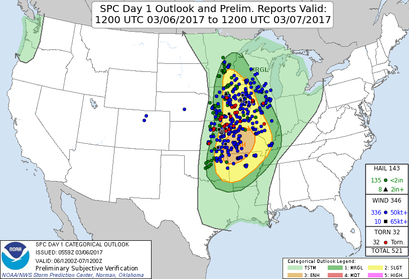 |
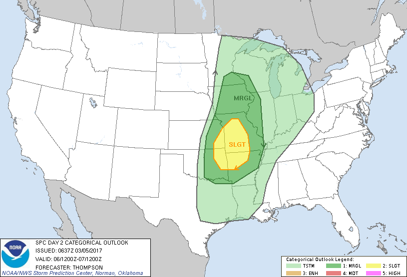
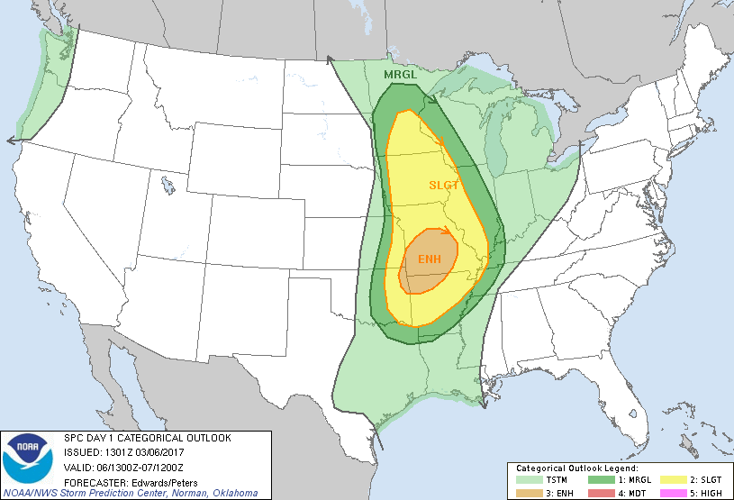
| Day Before: The Storm Prediction Center began indicating a risk for severe thunderstorms Sunday morning | Day Of: The Storm Prediction Center expanded the risk for severe storms over more of the area by early Monday morning. | The Storm Prediction Center outlook verified quite nicely across the region. |
Preliminary Look at Severe Thunderstorm Warning Verification:
| Number of Warnings Issued | Average Lead Time |
| 15 | 26.2 minutes |
Summaries from other NWS Offices
 |
Media use of NWS Web News Stories is encouraged! Please acknowledge the NWS as the source of any news information accessed from this site. |
|


 Weather Story
 Weather Map
 Local Radar