Overview
|
A surface boundary extended from southern Minnesota into northeast Iowa on Wednesday, June 17th. Warm and moist air pooled up to this boundary, leading to shower and thunderstorm development by early evening. The atmosphere was unstable enough and wind shear was favorable for storms to become severe very rapidly, producing large hail and even a couple tornadoes. The confirmed tornadoes were located in Mower County, Minnesota - in and around Austin (damage path) and several miles west of LeRoy, MN. |
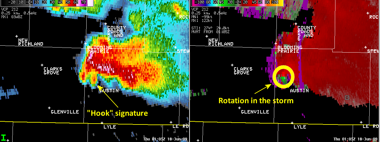 Radar loop of the Austin, MN tornado |
Tornadoes:
|
Tornado - Austin, MN
Track Map 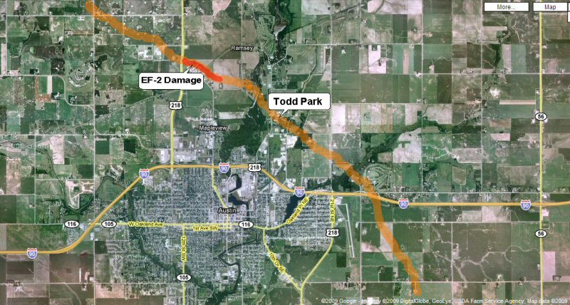 |
||||||||||||||||
The Enhanced Fujita (EF) Scale classifies tornadoes into the following categories:
| EF0 Weak 65-85 mph |
EF1 Moderate 86-110 mph |
EF2 Significant 111-135 mph |
EF3 Severe 136-165 mph |
EF4 Extreme 166-200 mph |
EF5 Catastrophic 200+ mph |
 |
|||||
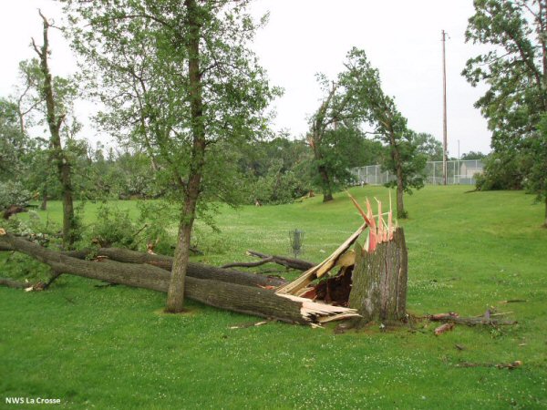
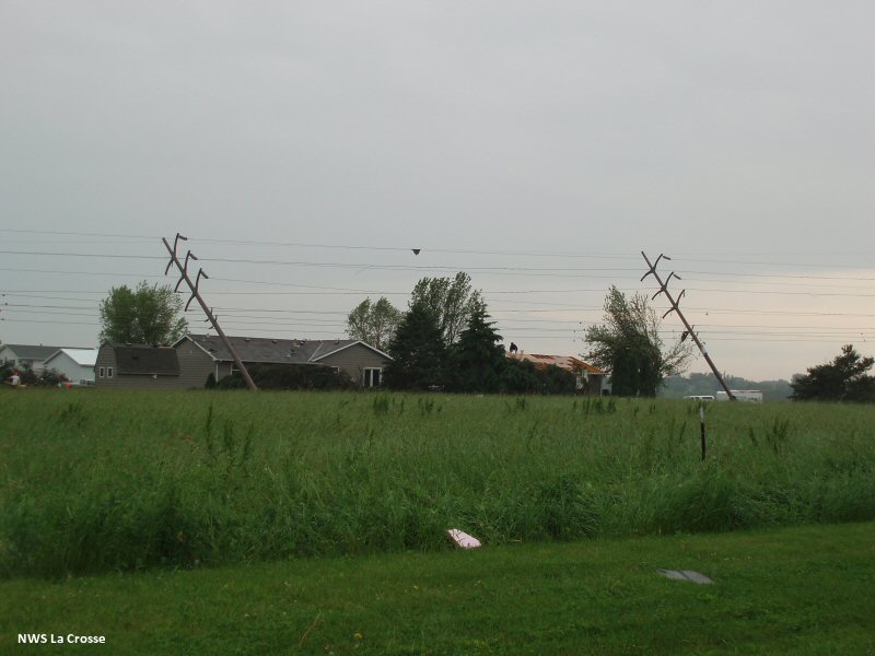
Damage Survey
PUBLIC INFORMATION STATEMENT
NATIONAL WEATHER SERVICE LA CROSSE WI
245 PM CDT THU JUN 18 2009
...AUSTIN MINNESOTA TORNADO SURVEY RESULTS...
STAFF FROM THE LA CROSSE NATIONAL WEATHER SERVICE SURVEYED STORM
DAMAGE TODAY IN MOWER COUNTY MINNESOTA...INCLUDING THE CITY OF
AUSTIN. SEVERE STORMS FORMED QUICKLY WEDNESDAY EVENING AND TRACKED
THROUGH SECTIONS OF SOUTHEAST MINNESOTA.
A TORNADO TRACK WAS FOUND ACROSS MOWER COUNTY...FROM NEAR THE DODGE
AND MOWER COUNTY LINE NORTHWEST OF AUSTIN THROUGH FAR NORTH SECTIONS
OF AUSTIN TO AREAS ABOUT 3 MILES EAST OF AUSTIN. THE WORST TORNADO
DAMAGE WAS CONSIDERED EF2 ON THE EF-SCALE ABOUT 3 MILES NORTH OF
DOWNTOWN AUSTIN NEAR THE INTERSECTION OF 243RD STREET AND 4TH STREET
NORTHWEST. A BULK OF THE REMAINING DAMAGE WAS CONSIDERED EF0 AND
EF1. APPROXIMATE TIME OF THE TORNADO WAS 800 TO 823 PM WEDNESDAY
EVENING...JUNE 17TH. THE LENGTH WAS ABOUT 10 MILES LONG WITH A
MAXIMUM WIDTH OF 120 YARDS.
HERE ARE MORE DETAILS...
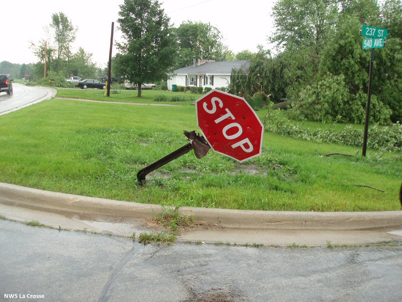
* MINOR TREE DAMAGE WAS NOTED NEAR 515TH AVE AND 250TH STREET
NORTHWEST OF AUSTIN.
* ROTATION WAS FOUND IN HIGH GRASS ALONG 520TH AVE.
* DEBRIS WAS BLOWN INTO FENCES AND POLES WERE BENT NEAR THE
LANDFILL ALONG 243RD STREET NORTH-NORTHWEST OF AUSTIN.
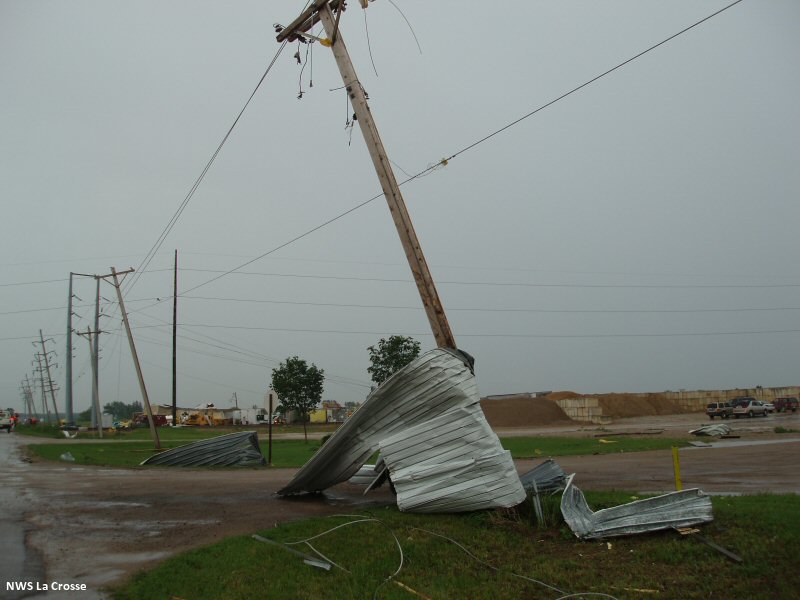
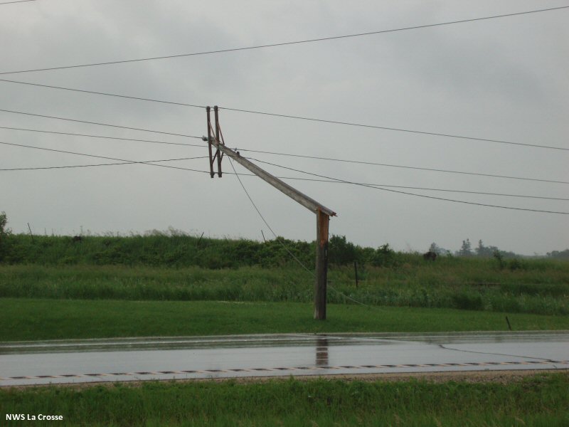
* SEVERAL POWER POLES WERE SNAPPED OR BENT ALONG HIGHWAY 218
NORTH OF AUSTIN.
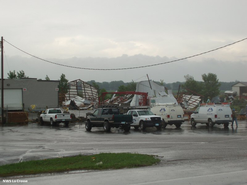
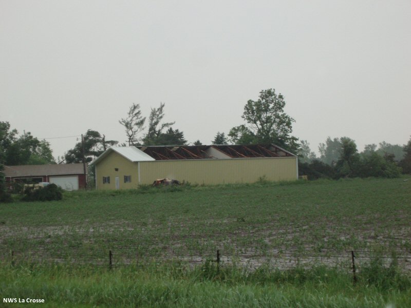
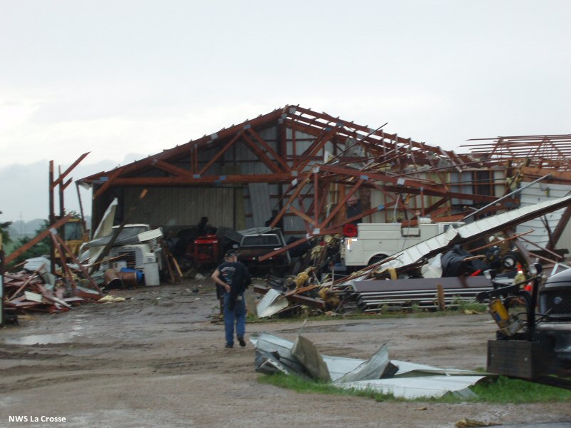
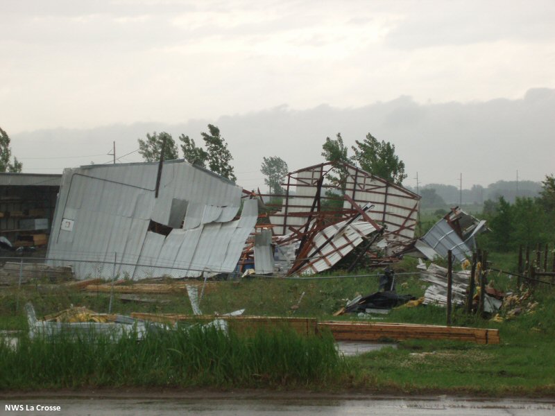
* SEVERAL METAL WORK BUILDINGS WERE HEAVILY DAMAGED ALONG 243RD
STREET ALONG WITH NUMEROUS TREES AND SOME MINOR ROOF DAMAGE TO
NEARBY HOMES. LARGE DEBRIS LIKE METAL DUMPSTERS WERE TOSSED
LARGE DISTANCES.
* THERE WAS STRAIGHT LINE WIND DAMAGE NOTED SOUTH OF THE TORNADO
PATH SOUTH OF THIS AREA...ALONG HIGHWAY 218 AND 4TH STREET NW.
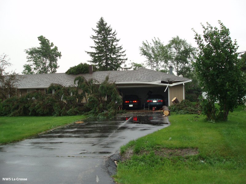
* SEVERAL HOMES HAD MINOR DAMAGE WITH NUMEROUS TREES BLOWN OVER
OR SHEARED ALONG 236TH AND 237TH STREETS DIRECTLY NORTH OF
AUSTIN.
* SMALL BUILDINGS AND PICNIC TABLES WERE TOSSED AT BUSINESSES
ALONG 11TH STREET NE NEAR TODD PARK ON THE NORTH SIDE OF
AUSTIN.
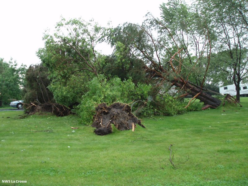
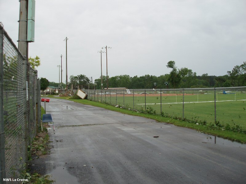
* THERE WAS CONSIDERABLE DAMAGE DONE IN TODD PARK...INCLUDING
ATHLETIC EQUIPMENT DAMAGE...SMALL BUILDINGS AND HUNDREDS OF
TREES TOPPLED AND UPROOTED. THE NORTH PART OF THE PARK...
INCLUDING THE NORTHERN SOFTBALL FIELDS HAD THE MOST DAMAGE.
* SOME BUILDINGS WERE DAMAGED ALONG 21ST AVE NE SOUTH OF TODD
PARK BUT THAT APPEARED TO BE STRAIGHT LINE WIND SOUTH OF THE
TORNADO PATH.
* THERE WAS ALSO CONSIDERABLE TREE DAMAGE ALONG 21ST STREET NE
OR 555TH AVE WHICH CONTINUED INTO THE AUSTIN COUNTRY CLUB.
* MINOR DAMAGE WAS NOTED TO FARMS ABOUT A HALF MILE EAST OF THE
AUSTIN AIRPORT AND ABOUT 2 MILES SOUTHEAST OF THE AIRPORT.
Photos:
 |
 |
 |
 |
 |
 |
 |
 |
 |
 |
 |
 |
Storm Reports
 PRELIMINARY LOCAL STORM REPORT...SUMMARY
NATIONAL WEATHER SERVICE LA CROSSE WI
230 PM CDT THU JUN 18 2009

..TIME...   ...EVENT...      ...CITY LOCATION...     ...LAT.LON...
..DATE...   ....MAG....      ..COUNTY LOCATION..ST.. ...SOURCE....
            ..REMARKS..

0726 PM     FUNNEL CLOUD     2 S CHARLES CITY        43.04N 92.68W
06/17/2009                   FLOYD              IA   BROADCAST MEDIA

            BRIEF FUNNEL CLOUD REPORTED BY BROADCAST MEDIA

0726 PM     FUNNEL CLOUD     2 E ROCKFORD            43.05N 92.91W
06/17/2009                   FLOYD              IA   TRAINED SPOTTER

0726 PM     FUNNEL CLOUD     2 NE ROCKFORD           43.07N 92.92W
06/17/2009                   FLOYD              IA   TRAINED SPOTTER

            TRAINED SPOTTER REPORTED A FUNNEL CLOUD AT 190TH STREET
            AND GLASS AVENUE

0733 PM     FUNNEL CLOUD     3 SE BLOOMING PRAIRIE   43.84N 93.01W
06/17/2009                   MOWER              MN   TRAINED SPOTTER

0733 PM     HAIL             1 S CLAREMONT           44.03N 93.00W
06/17/2009  E0.75 INCH       DODGE              MN   LAW ENFORCEMENT

            LAW ENFORCEMENT REPORTED DIME SIZE HAIL SOUTH OF
            CLAREMONT

0733 PM     HAIL             1 S CLAREMONT           44.03N 93.00W
06/17/2009  E0.75 INCH       DODGE              MN   LAW ENFORCEMENT

0737 PM     HAIL             BLOOMING PRAIRIE        43.87N 93.05W
06/17/2009  E3.00 INCH       DODGE              MN   BROADCAST MEDIA

0742 PM     HAIL             ELMA                    43.25N 92.44W
06/17/2009  E0.75 INCH       HOWARD             IA   PUBLIC

            PEA TO DIME SIZE HAIL IN TOWN

0808 PM     HAIL             4 W BASSETT             43.06N 92.59W
06/17/2009  M1.00 INCH       FLOYD              IA   LAW ENFORCEMENT

0808 PM     TORNADO          1 NW AUSTIN             43.68N 92.98W
06/17/2009                   MOWER              MN   TRAINED SPOTTER

            LARGE TORNADO ON THE GROUND WITH DEBRIS ON THE NORTHWEST
            SIDE OF AUSTIN

0810 PM     TORNADO          AUSTIN                  43.67N 92.97W
06/17/2009                   MOWER              MN   LAW ENFORCEMENT

            LARGE AMOUNT OF DAMAGE IN AUSTIN AND ESPECIALLY ON THE
            NORTH SIDE. MINOR INJURIES BEING REPORTED THUS FAR.

0820 PM     HAIL             LIME SPRINGS            43.45N 92.28W
06/17/2009  E1.00 INCH       HOWARD             IA   TRAINED SPOTTER

0825 PM     TORNADO          4 NW NASHUA             42.99N 92.60W
06/17/2009                   FLOYD              IA   TRAINED SPOTTER

0827 PM     HAIL             2 E AUSTIN              43.67N 92.93W
06/17/2009  E1.50 INCH       MOWER              MN   PUBLIC

            RELAYED FROM MEDIA

0844 PM     FUNNEL CLOUD     5 NW ADAMS              43.62N 92.79W
06/17/2009                   MOWER              MN   FIRE DEPT/RESCUE

0856 PM     HAIL             CLAREMONT               44.04N 93.00W
06/17/2009  E0.88 INCH       DODGE              MN   LAW ENFORCEMENT

0857 PM     HAIL             3 NW LE ROY             43.54N 92.55W
06/17/2009  E0.75 INCH       MOWER              MN   FIRE DEPT/RESCUE

0858 PM     HAIL             3 NW NEW HAMPTON        43.09N 92.36W
06/17/2009  E0.75 INCH       CHICKASAW          IA   PUBLIC

0913 PM     HAIL             3 NNW LE ROY            43.55N 92.53W
06/17/2009  E1.75 INCH       MOWER              MN   FIRE DEPT/RESCUE

0923 PM     HAIL             LIME SPRINGS            43.45N 92.28W
06/17/2009  E1.75 INCH       HOWARD             IA   LAW ENFORCEMENT

0956 PM     HAIL             ELMA                    43.25N 92.44W
06/17/2009  E1.00 INCH       HOWARD             IA   LAW ENFORCEMENT

0956 PM     HAIL             CRESCO                  43.37N 92.12W
06/17/2009  E0.75 INCH       HOWARD             IA   LAW ENFORCEMENT

1009 PM     HAIL             5 W WEST UNION          42.96N 91.91W
06/17/2009  E0.88 INCH       FAYETTE            IA   LAW ENFORCEMENT

1032 PM     HAIL             PROTIVIN                43.22N 92.09W
06/17/2009  E0.50 INCH       HOWARD             IA   LAW ENFORCEMENT

1058 PM     HEAVY RAIN       3 S WAUCOMA             43.01N 92.03W
06/17/2009  M3.52 INCH       FAYETTE            IA   TRAINED SPOTTER

1100 PM     FLASH FLOOD      1 N LAWLER              43.09N 92.15W
06/17/2009                   CHICKASAW          IA   EMERGENCY MNGR

            FEW INCHES OF WATER OVER ROADS IN SEVERAL LOCATIONS. MANY
            SPOTS ALONG N-S ROADS CR V56 AND VANDERBILT AVE...AS WELL
            AS ALONG W-E ROAD 190TH ST. ALSO REPORTS OF SOME WASHED
            OUT FARMERS DIKES IN THE AREA.

1131 PM     TSTM WND DMG     LAWLER                  43.07N 92.15W
06/17/2009                   CHICKASAW          IA   LAW ENFORCEMENT

            LAW ENFORCEMENT REPORTS POWER LINES AND TREES DOWN IN THE
            CITY OF LAWLER

1131 PM     HAIL             LAWLER                  43.07N 92.15W
06/17/2009  M1.75 INCH       CHICKASAW          IA   LAW ENFORCEMENT

1135 PM     HAIL             2 N LAWLER              43.10N 92.15W
06/17/2009  E1.75 INCH       CHICKASAW          IA   EMERGENCY MNGR

            CROPS IN APPROX 15 SECTIONS OF LAND NORTH OF LAWLER
            STRIPPED/DESTROYED. ALSO SOME WINDOW/SIDING/ROOF DAMAGE
            IN THE AREA. AREAS IMPACTED LIE BETWEEN W-E ORIENTED
            STATE HWY 24 AND CR B33 AND A CORRIDOR 2 MILES WEST AND
            EAST OF N-S ORIENTED CR V56. ALSO...HAIL IN THE ENTIRE
            AREA ESTIMATED BETWEEN 1 AND 2 INCH DIAMETER.

1144 PM     HAIL             3 S WAUCOMA             43.01N 92.03W
06/17/2009  E1.75 INCH       FAYETTE            IA   PUBLIC

            RELAYED FROM MEDIA...HAIL A BIT LARGER THAN GOLF BALL
            SIZE WITH SINGLE LINE OF SPIKES AROUND THEM...BROKE
            WINDOWS AND DID SOME DAMAGE TO HOUSE SIDING. ALSO...TOTAL
            OF 4.80 INCHES OF RAIN.

1148 PM     HAIL             3 SE WAUCOMA            43.02N 91.99W
06/17/2009  M1.50 INCH       FAYETTE            IA   TRAINED SPOTTER

1148 PM     HAIL             3 SE WAUCOMA            43.02N 91.99W
06/17/2009  M2.00 INCH       FAYETTE            IA   TRAINED SPOTTER


&&
 |
Media use of NWS Web News Stories is encouraged! Please acknowledge the NWS as the source of any news information accessed from this site. |
|


 Weather Story
 Weather Map
 Local Radar