Overview
|
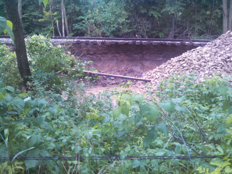
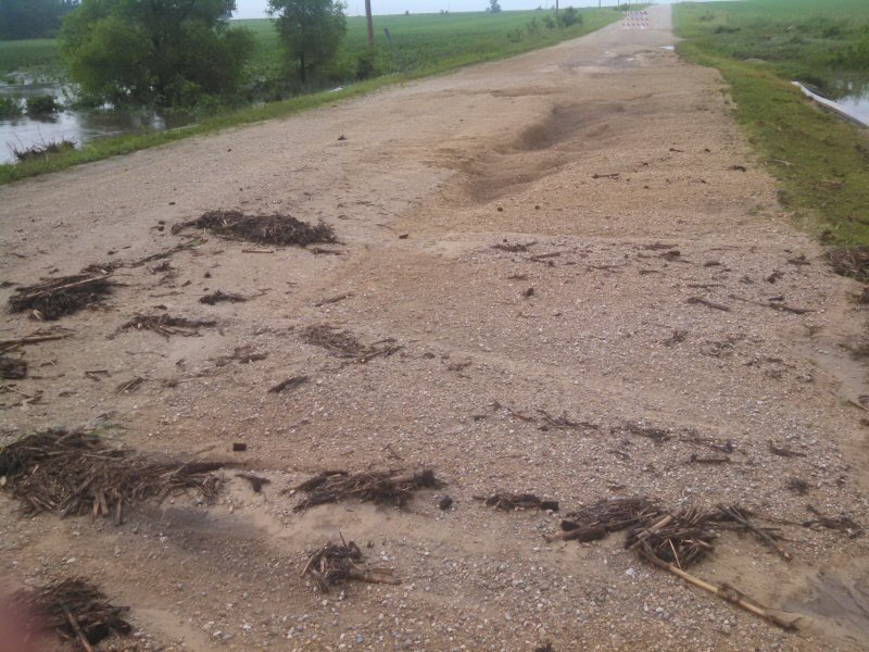
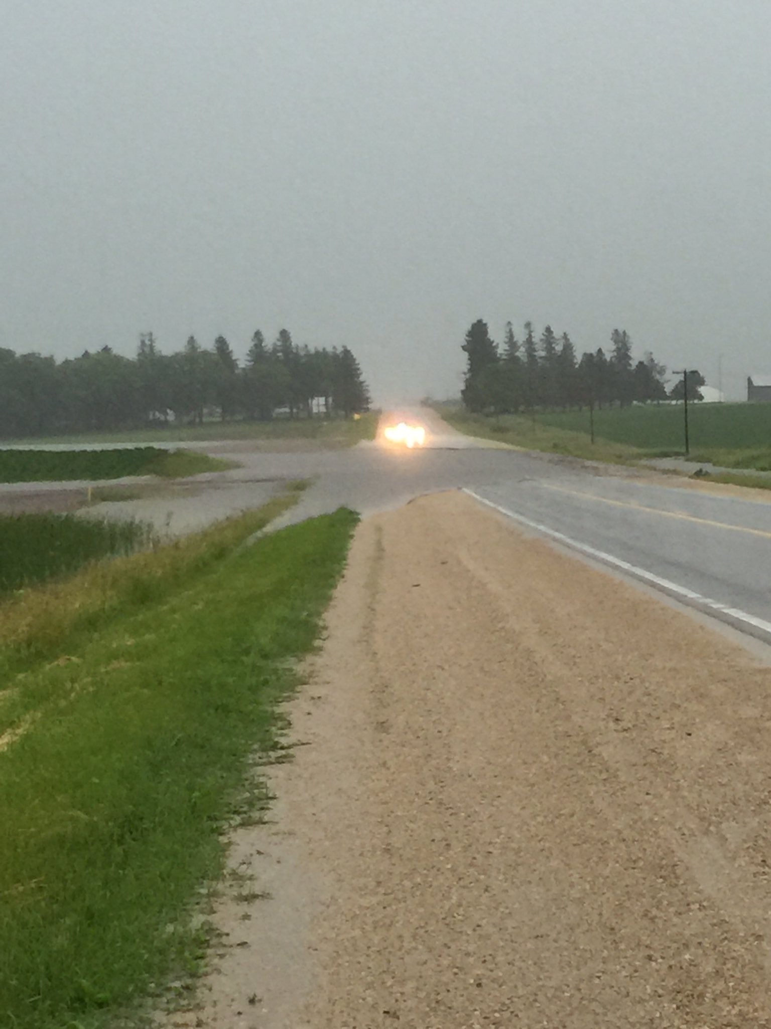
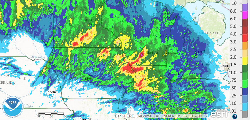
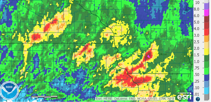
Several rounds of thunderstorms brought heavy rain to parts of the region on Tuesday, June 14th. Some rainfall totals were in the 3 to 6 inch range, and combined with rainfall from the first half of the month, river flooding and flash flooding occurred. The hardest hit areas were northeast Iowa into far southwest Wisconsin, where numerous roads were covered with high water, washed out, and/or damaged. Rivers around the region also rose quickly, exceeding flood stage briefly, and some street flooding was reported in urban areas. In addition to the heavy rain and flooding, the storms also produced sporadic hail and strong winds as they moved through. |
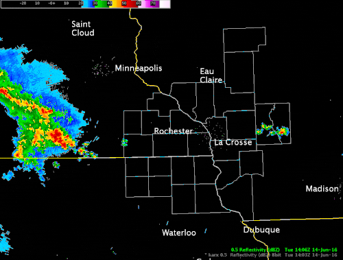 Radar loop from 9 a.m. to Midnight - June 14, 2016 |
Flooding
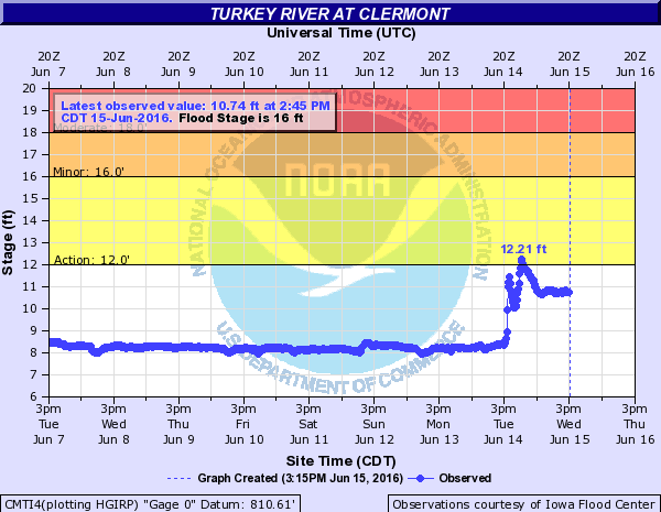
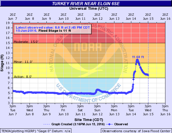
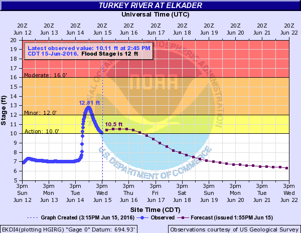
Here are hydrographs from northeast Iowa that show how water levels rose along the Cedar, Turkey, and Volga Rivers.
Hydrographs
 |
 |
 |
 |
| Clermont, IA | Between Elgin and Elkader, IA | Elkader, IA | Garber, IA |
 |
 |
 |
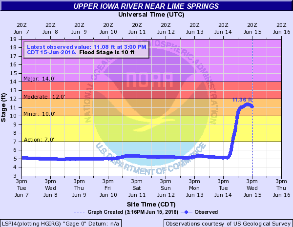 |
| Charles City, IA | Volga, IA | Littleport, IA | Lime Springs, IA |
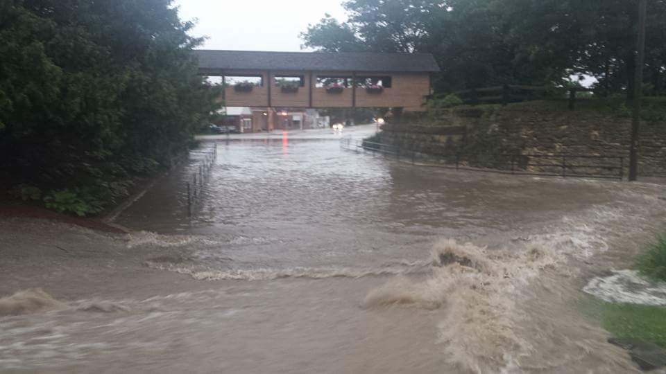
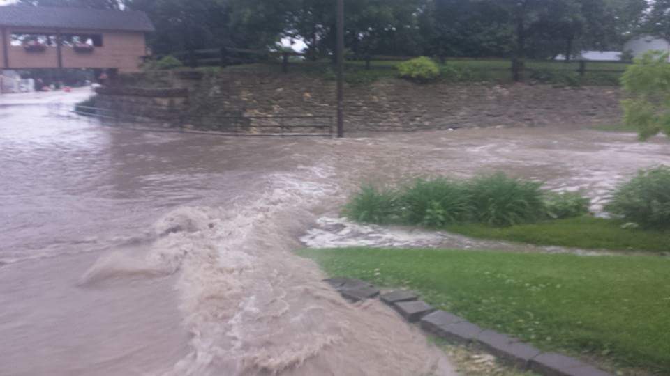
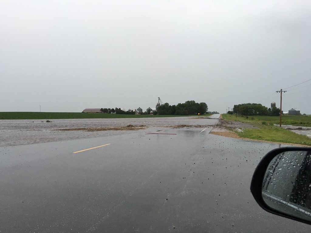
Photos
 |
 |
 |
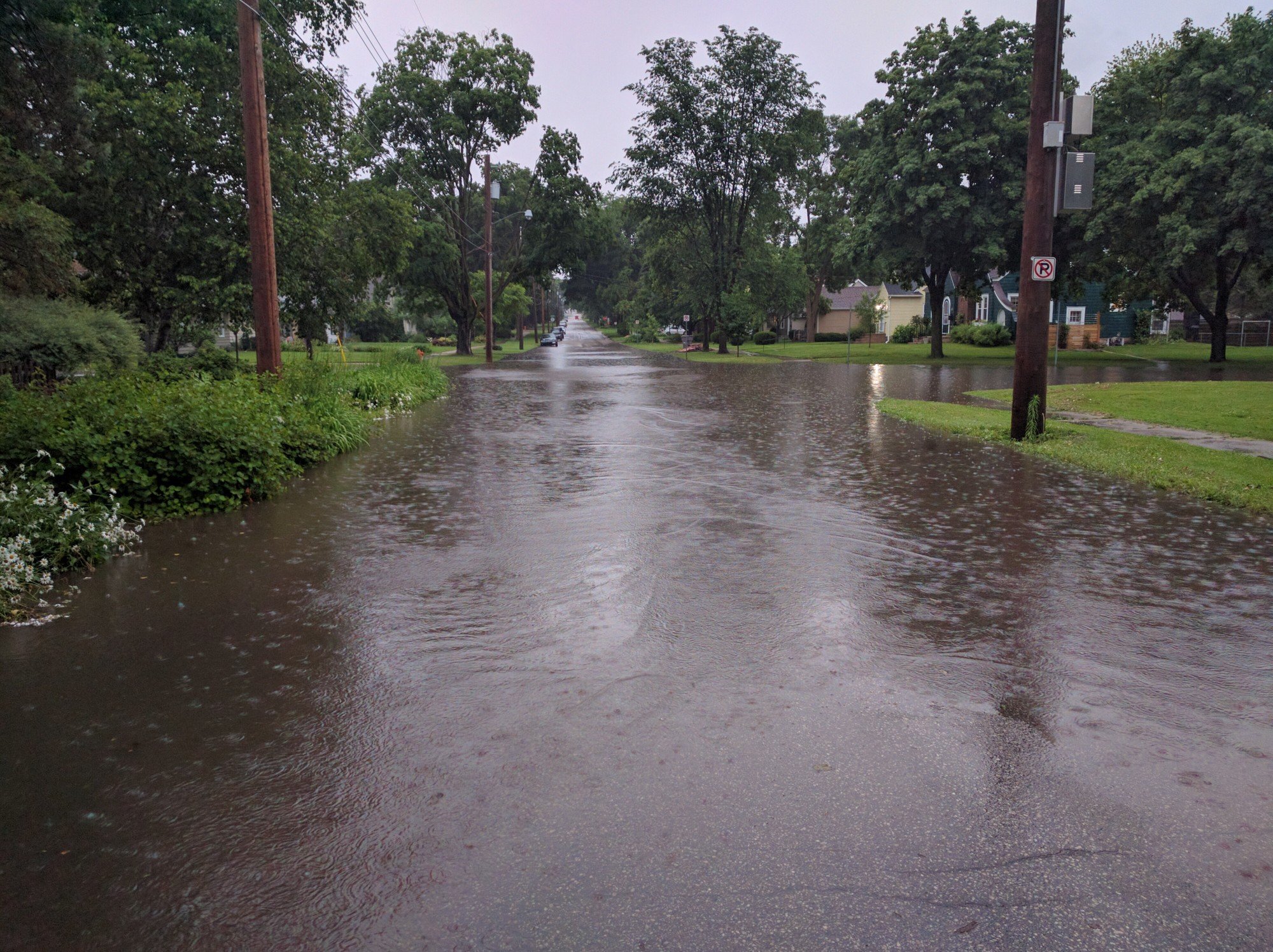 |
| Flooding in Elma, IA (Photo by Kim Possible) |
Flooding in Elma, IA (Photo by Kim Possible) |
Flooding east of Riceville, IA (Photo by Barry Christensen) |
Street flooding in Rochester, MN (Photo by Wade Kreun) |
 |
 |
 |
|
| Near Orchard, IA (Photo by Mitchell Co. Emerg.Mgmt) |
Rural Mitchell County, IA (Photo by Mitchell Co. Emerg.Mgmt) |
Near Osage, IA (Photo by Nick Hoppel) |
Rainfall Maps
 |
 |
| Regional rainfall map from June 14-15th | Local rainfall map from June 14-15th |
Rain Reports
Public Information Statement
National Weather Service La Crosse WI
1147 AM CDT Wed Jun 15 2016

...Rainfall Reports from June 14th...

Location                     Amount    Time/Date       Lat/Lon

...Iowa...

...Allamakee County...
4 ENE Watson                 1.59 in   1045 AM 06/15   43.11N/91.26W
3 SE Waterville              1.09 in   1007 AM 06/15   43.17N/91.24W
Harpers Ferry                1.02 in   0902 PM 06/14   43.20N/91.15W

...Chickasaw County...
New Hampton                  2.75 in   0700 AM 06/15   43.06N/92.31W
Ionia 2W                     2.58 in   1045 AM 06/15   43.03N/92.50W

...Clayton County...
Guttenberg Dam 10            3.27 in   0600 AM 06/15   42.78N/91.10W
Volga 1NE                    2.56 in   0600 AM 06/15   42.81N/91.52W
Elkader Turkey River         1.76 in   1045 AM 06/15   42.84N/91.40W
Edgewood                     1.65 in   0700 AM 06/15   42.65N/91.40W
Littleport                   1.57 in   1045 AM 06/15   42.75N/91.37W
Garber                       0.56 in   1015 AM 06/15   42.74N/91.26W
Marquette-Bloody Run Creek   0.55 in   1100 AM 06/15   43.04N/91.21W
Mcgregor 2                   0.46 in   1045 AM 06/15   43.02N/91.17W

...Fayette County...
Fayette                      2.00 in   0700 AM 06/15   42.85N/91.82W
Eldorado                     1.93 in   1045 AM 06/15   43.05N/91.81W
Oelwein Municipal Airport    1.73 in   0655 AM 06/15   42.68N/91.97W

...Floyd County...
Nora Springs 2.4 SSE         4.25 in   0700 AM 06/15   43.11N/92.99W
Rockford-Shell Rock Rvr      2.50 in   1045 AM 06/15   43.01N/92.93W
Charles City                 2.26 in   0700 AM 06/15   43.06N/92.67W
Colwell                      2.09 in   0700 AM 06/15   43.16N/92.59W
Nashua 2 SW                  1.95 in   0600 AM 06/15   42.94N/92.57W
Charles City-Cedar River     1.59 in   1030 AM 06/15   43.06N/92.67W
Charles City Airport         1.29 in   0655 AM 06/15   43.07N/92.61W

...Howard County...
Riceville                    5.54 in   0746 AM 06/15   43.36N/92.55W
2 SW Lourdes                 3.80 in   0747 AM 06/15   43.25N/92.32W
3 NE Riceville               3.79 in   1102 AM 06/15   43.40N/92.50W
Cresco 1 NE                  1.83 in   0700 AM 06/15   43.39N/92.09W

...Mitchell County...
Osage                        2.41 in   0700 AM 06/15   43.28N/92.81W
St Ansgar                    1.02 in   0630 AM 06/15   43.38N/92.92W

...Winneshiek County...
7 ENE Decorah                1.27 in   0800 AM 06/15   43.34N/91.64W
Bluffton                     1.26 in   1045 AM 06/15   43.41N/91.90W
Decorah 6 ESE                0.99 in   0700 AM 06/15   43.27N/91.68W
Decorah Municipal Airport    0.67 in   0655 AM 06/15   43.28N/91.74W

...Minnesota...

...Dodge County...
MANTORVILLE 2ESE             1.43 in   0900 PM 06/14   44.05N/92.72W
Dodge Center Airport         1.38 in   0654 AM 06/15   44.02N/92.83W
2 E Claremont                1.19 in   0800 AM 06/15   44.04N/92.95W
Hayfield                     0.52 in   1107 AM 06/15   43.89N/92.85W

...Fillmore County...
7 N Mabel                    2.24 in   1005 PM 06/14   43.62N/91.77W
HIGHLAND 2SE                 2.24 in   0800 PM 06/14   43.65N/91.84W
Harmony                      2.07 in   0730 AM 06/15   43.55N/92.01W
PETERSON 1S                  2.06 in   0645 AM 06/15   43.78N/91.82W
Mabel                        2.03 in   0645 AM 06/15   43.52N/91.76W
Lanesboro 2NE                1.78 in   0700 AM 06/15   43.73N/91.94W
Preston                      1.70 in   0724 AM 06/15   43.67N/92.07W
Lanesboro-Root River         1.45 in   1030 AM 06/15   43.72N/91.98W
Chatfield                    1.05 in   0700 AM 06/15   43.84N/92.20W
Fillmore                     1.00 in   1030 AM 06/15   43.76N/92.27W
1 W Fillmore                 0.95 in   0700 AM 06/15   43.74N/92.31W
Pilot Mound-Root River       0.93 in   1100 AM 06/15   43.78N/92.03W
Spring Valley                0.91 in   0615 AM 06/15   43.69N/92.39W
Preston Airport              0.44 in   0654 AM 06/15   43.68N/92.18W

...Houston County...
Houston                      2.83 in   1045 AM 06/15   43.77N/91.57W
Mound Prairie                2.16 in   1045 AM 06/15   43.78N/91.45W
Caledonia                    1.51 in   0700 AM 06/15   43.63N/91.50W

...Mower County...
Austin 3S                    1.33 in   1100 AM 06/15   43.64N/92.97W
1 ENE Austin                 1.17 in   0810 AM 06/15   43.68N/92.94W
Austin 2 NE-Dobbins Creek    1.16 in   1030 AM 06/15   43.67N/92.95W
Lansing-Cedar River          1.10 in   1030 AM 06/15   43.75N/92.95W
Austin Municipal Airport     0.99 in   0655 AM 06/15   43.66N/92.93W
Austin 3 NW - Turtle Creek   0.67 in   1030 AM 06/15   43.65N/92.98W
Grand Meadow                 0.63 in   0530 AM 06/15   43.71N/92.56W

...Olmsted County...
Rochester-Cascade Creek      1.41 in   1030 AM 06/15   44.03N/92.47W
4 NNW Rochester              1.40 in   0700 AM 06/15   44.07N/92.49W
3 ESE Douglas                1.34 in   1110 AM 06/15   44.09N/92.51W
4 ESE Douglas                1.29 in   1110 AM 06/15   44.09N/92.49W
Rochester-Beltline           1.26 in   1030 AM 06/15   44.01N/92.47W
Rochester 3W                 1.21 in   1030 AM 06/15   44.02N/92.53W
2 N Rock Dell                1.21 in   0600 AM 06/15   43.96N/92.63W
5 E Douglas                  1.20 in   1000 AM 06/15   44.10N/92.47W
3 W Rochester                1.20 in   1030 PM 06/14   44.02N/92.53W
3 N Rochester                1.14 in   1015 AM 06/15   44.06N/92.47W
Pine Island 1S               1.11 in   1100 AM 06/15   44.19N/92.65W
Rochester International Airp 1.08 in   0654 AM 06/15   43.91N/92.50W
Byron 4 North                1.07 in   0700 AM 06/15   44.09N/92.64W
Mayo Helipad                 1.06 in   0655 AM 06/15   44.02N/92.48W
Byron                        1.05 in   1111 AM 06/15   44.04N/92.64W
1 W Chester                  1.02 in   0630 AM 06/15   44.00N/92.38W
Elgin 5SE                    0.95 in   1030 AM 06/15   44.01N/92.11W
3 NE Rochester               0.90 in   1114 AM 06/15   44.05N/92.45W
Elgin 2 SSW                  0.89 in   0700 AM 06/15   44.10N/92.27W
Elba 4.7 SW                  0.87 in   1030 PM 06/14   44.04N/92.09W
2 NE Rochester               0.77 in   1100 AM 06/15   44.04N/92.44W
Oronoco                      0.75 in   1030 AM 06/15   44.16N/92.54W
Oronoco 1W                   0.73 in   1030 AM 06/15   44.17N/92.55W

...Wabasha County...
Plainview                    1.47 in   1112 AM 06/15   44.17N/92.17W
Theilman 1SSW                0.92 in   0800 AM 06/15   44.28N/92.19W
Mazeppa 3ESE                 0.91 in   1030 AM 06/15   44.26N/92.49W
2 NNW Zumbro Falls           0.87 in   0949 AM 06/15   44.32N/92.44W
3 SW Zumbro Falls            0.87 in   0550 AM 06/15   44.24N/92.46W
Wabasha                      0.75 in   0700 AM 06/15   44.38N/92.05W
Kellogg-Zumbro River         0.64 in   1100 AM 06/15   44.32N/92.00W

...Winona County...
Dakota                       1.88 in   1015 AM 06/15   43.91N/91.36W
4SW Winona                   1.80 in   0625 AM 06/15   43.98N/91.71W
La Crescent Dam 7            1.78 in   0600 AM 06/15   43.87N/91.31W
2 NW Wilson                  1.68 in   0857 PM 06/14   43.98N/91.71W
3 ESE Stockton               1.68 in   0856 PM 06/14   44.01N/91.71W
2 NNW Pickwick               1.45 in   0700 AM 06/15   44.02N/91.61W
Winona Municipal Airport     1.08 in   0653 AM 06/15   44.08N/91.71W
Winona Dam 5a                1.00 in   0600 AM 06/15   44.09N/91.67W
1 E Winona                   0.98 in   1110 AM 06/15   44.05N/91.63W
Minnesota City Dam 5         0.90 in   0700 AM 06/15   44.16N/91.81W
Whitewater State Park Group  0.85 in   1030 AM 06/15   44.06N/92.05W
Whitewater State Park        0.77 in   1030 AM 06/15   44.05N/92.05W
Elba                         0.70 in   1045 AM 06/15   44.09N/92.03W
Beaver-White Water River     0.42 in   1045 AM 06/15   44.15N/92.00W

...Wisconsin...

...Adams County...
Monroe Center 1E             0.62 in   0700 AM 06/15   44.11N/89.92W
Castle Rock                  0.57 in   0800 AM 06/15   43.87N/89.95W
Petenwell Lake               0.35 in   0735 AM 06/15   44.08N/90.00W

...Buffalo County...
Buffalo                      0.97 in   0943 AM 06/15   44.23N/91.86W
Mondovi                      0.91 in   0942 AM 06/15   44.57N/91.66W
Alama Dam 4                  0.53 in   0600 AM 06/15   44.33N/91.92W

...Clark County...
Neillsville 1W               1.43 in   1100 AM 06/15   44.56N/90.61W
Owen 2N                      0.68 in   0800 AM 06/15   44.98N/90.55W

...Crawford County...
Prairie Du Chien  Airport    3.49 in   0655 AM 06/15   43.02N/91.12W
Prairie Du Chien             2.95 in   0700 AM 06/15   43.05N/91.13W
De Soto                      1.72 in   1111 AM 06/15   43.42N/91.19W
De Soto 1SE                  1.71 in   0500 AM 06/15   43.42N/91.19W
Lynxville Dam 9              1.65 in   0600 AM 06/15   43.21N/91.10W
Steuben                      0.84 in   1045 AM 06/15   43.18N/90.86W
Steuben 4SE                  0.65 in   0634 AM 06/15   43.13N/90.84W
Gays Mills                   0.57 in   0800 AM 06/15   43.32N/90.85W

...Grant County...
Hazel Green                  3.10 in   1052 PM 06/14   42.53N/90.43W
Glen Haven                   2.90 in   0828 PM 06/14   42.83N/91.07W
3 NNW Burton                 2.50 in   0700 AM 06/15   42.75N/90.83W
Platteville Municipal Airpor 2.43 in   0655 AM 06/15   42.69N/90.44W
Platteville                  2.40 in   0715 AM 06/15   42.74N/90.48W
Lancaster 4wsw               1.63 in   0800 AM 06/15   42.83N/90.79W
Muscoda                      0.54 in   1045 AM 06/15   43.20N/90.44W
Boscobel Airport             0.46 in   0653 AM 06/15   43.16N/90.67W
1 ENE Boscobel               0.42 in   1103 AM 06/15   43.15N/90.68W

...Jackson County...
1 E Black River Falls        1.45 in   1015 AM 06/15   44.30N/90.83W
Hatfield Dam                 1.37 in   0811 AM 06/15   44.41N/90.73W
Black River Falls Sewage     1.34 in   0830 AM 06/15   44.29N/90.85W
Black River Falls Area Airpo 1.13 in   0655 AM 06/15   44.25N/90.86W

...Juneau County...
Union Center                 1.23 in   0715 AM 06/15   43.68N/90.26W
Volk Field                   0.94 in   0658 AM 06/15   43.94N/90.25W
4 ESE Sprague                0.68 in   0800 AM 06/15   44.10N/90.06W
Mauston                      0.59 in   1112 AM 06/15   43.80N/90.07W
Mauston Airport              0.52 in   0655 AM 06/15   43.84N/90.14W
Necedah                      0.52 in   1048 AM 06/15   44.03N/90.08W
2 N Cloverdale               0.47 in   1110 AM 06/15   44.06N/90.17W
New Lisbon 4ene              0.46 in   0700 AM 06/15   43.91N/90.07W

...La Crosse County...
4 NW Rockland                3.24 in   0945 PM 06/14   43.96N/90.97W
WFO La Crosse                3.09 in   1105 AM 06/15   43.82N/91.19W
Bangor                       2.50 in   0909 AM 06/15   43.89N/90.99W
3 W Saint Joseph             1.94 in   1105 AM 06/15   43.78N/91.10W
La Crosse Regional Airport   1.92 in   0653 AM 06/15   43.88N/91.26W
Holmen 2 S                   1.88 in   0700 AM 06/15   43.93N/91.25W
West Salem 2 W               1.82 in   0700 AM 06/15   43.90N/91.12W
La Crosse 4NNW               1.66 in   0730 AM 06/15   43.87N/91.27W

...Monroe County...
Sparta                       1.98 in   0800 AM 06/15   43.94N/90.82W
Sparta/Fort McCoy Airport    1.55 in   0655 AM 06/15   43.96N/90.74W
Cashton 3NNW                 1.53 in   0739 AM 06/15   43.79N/90.80W
Four Corners                 1.37 in   0700 AM 06/15   44.09N/90.91W
2 E Cataract                 1.26 in   1114 AM 06/15   44.09N/90.79W
Tunnel City                  1.22 in   0700 AM 06/15   44.01N/90.57W
Kendall                      1.16 in   1115 AM 06/15   43.79N/90.37W
Warrens 4WSW                 1.15 in   0700 AM 06/15   44.10N/90.59W

...Richland County...
3 NW Avoca                   1.70 in   1107 AM 06/15   43.23N/90.37W
Richland Center 4N           1.37 in   0700 AM 06/15   43.40N/90.39W

...Taylor County...
Chelsea                      0.75 in   1106 AM 06/15   45.30N/90.30W
Medford Airport              0.71 in   0655 AM 06/15   45.10N/90.30W
Medford                      0.70 in   0800 AM 06/15   45.13N/90.34W
3 NE Lublin                  0.47 in   1014 AM 06/15   45.11N/90.69W
Jump River 1 NW              0.27 in   0700 AM 06/15   45.36N/90.80W

...Trempealeau County...
1 NW Trempealeau             1.99 in   0600 AM 06/15   44.03N/91.46W
Galesville 2WSW              1.89 in   1030 PM 06/14   44.07N/91.39W
1 WSW Galesville             1.63 in   1112 AM 06/15   44.07N/91.39W
Trempealeau Dam 6            1.41 in   0600 AM 06/15   44.00N/91.44W
Ettrick 4WNW                 1.05 in   0737 AM 06/15   44.19N/91.34W
Dodge                        0.57 in   1045 AM 06/15   44.13N/91.55W

...Vernon County...
Stoddard                     1.93 in   0700 AM 06/15   43.66N/91.22W
Viroqua 0.8 ESE              1.70 in   0700 AM 06/15   43.55N/90.87W
Viroqua                      1.66 in   0700 AM 06/15   43.56N/90.88W
Genoa Dam 8                  1.61 in   0600 AM 06/15   43.57N/91.23W
Westby 3 ENE                 1.53 in   0700 AM 06/15   43.67N/90.81W
Readstown                    1.43 in   1100 AM 06/15   43.45N/90.76W
Hillsboro WSW                1.42 in   0700 AM 06/15   43.65N/90.35W
3 WNW Viola                  1.37 in   0800 AM 06/15   43.53N/90.74W
Hillsboro 2 SW               1.36 in   0700 AM 06/15   43.63N/90.38W
Readstown 4 NE               1.30 in   0700 AM 06/15   43.48N/90.69W
Viroqua Municipal Airport    1.26 in   0655 AM 06/15   43.58N/90.90W
La Farge                     1.20 in   0715 AM 06/15   43.57N/90.64W

Observations are collected from a variety of sources with varying
equipment and exposures. Not all data listed are considered official.
Storm Reports
PRELIMINARY LOCAL STORM REPORT...SUMMARY
NATIONAL WEATHER SERVICE LA CROSSE WI

..TIME...   ...EVENT...      ...CITY LOCATION...     ...LAT.LON...
..DATE...   ....MAG....      ..COUNTY LOCATION..ST.. ...SOURCE....
            ..REMARKS..

0445 PM     TSTM WND GST     CHARLES CITY            43.07N 92.68W
06/14/2016  M41 MPH          FLOYD              IA   AWOS

0940 PM     TSTM WND GST     PLATTEVILLE             42.74N 90.48W
06/14/2016  M46 MPH          GRANT              WI   AWOS

0915 PM     TSTM WND GST     VIROQUA                 43.56N 90.89W
06/14/2016  M49 MPH          VERNON             WI   AWOS

0625 PM     TSTM WND GST     4 N STEWARTVILLE        43.91N 92.50W
06/14/2016  M52 MPH          OLMSTED            MN   ASOS

0659 PM     FLASH FLOOD      4 E OSAGE               43.28N 92.73W
06/14/2016                   MITCHELL           IA   EMERGENCY MNGR

            WATER OVER HIGHWAY 9 EAST OF INTERSECTION
            WITH 218.

0624 PM     FLOOD            CHARLES CITY            43.07N 92.68W
06/14/2016                   FLOYD              IA   PUBLIC

            FLOODING ON CLARK STREET.

0435 PM     TSTM WND DMG     2 NE IONIA              43.06N 92.43W
06/14/2016                   CHICKASAW          IA   LAW ENFORCEMENT

            REPORTED NEAR HIGHWAY 18.

0650 PM     FLASH FLOOD      PRAIRIE DU CHIEN        43.04N 91.14W
06/14/2016                   CRAWFORD           WI   911 CALL CENTER

            FLOODING ON NORTH AND SOUTH SIDE OF TOWN.
            ALSO OVER PARTS OF HIGHWAY 27 IN COUNTY.

0349 PM     TSTM WND DMG     1 SW FROELICH           43.00N 91.33W
06/14/2016                   CLAYTON            IA   911 CALL CENTER

            SEMI TRUCK BLOWN OVER NEAR HIGHWAYS 52 AND
            13 FROM STORM.

0706 PM     FLASH FLOOD      3 NW SARATOGA           43.40N 92.44W
06/14/2016                   HOWARD             IA   AMATEUR RADIO

            HIGH WATER REPORTED IN VARIOUS AREAS OF THE
            COUNTY.

0710 PM     FLASH FLOOD      2 W DAVIS CORNERS       43.36N 92.34W
06/14/2016                   HOWARD             IA   AMATEUR RADIO

            CARS GOING INTO FLOOD WATERS AND PART OF
            HIGHWAY 9 MAY NEED TO BE SHUT DOWN BETWEEN
            RICEVILLE AND DAVIS CORNERS.

0733 PM     FLASH FLOOD      RUDD                    43.13N 92.90W
06/14/2016                   FLOYD              IA   911 CALL CENTER

            WASHED OUT ROADS AND WATER OVER ROADS IN
            SEVERAL LOCATIONS FROM MARBLE ROCK TO RUDD
            TO NORTH OF FLOYD.

0805 PM     FLOOD            4 W ALTA VISTA          43.20N 92.50W
06/14/2016                   CHICKASAW          IA   TRAINED SPOTTER

            REPORTS OF WATER OVER ROADS AND INTO
            BASEMENTS.

0908 PM     FLOOD            1 SW LA CROSSE          43.81N 91.25W
06/14/2016                   LA CROSSE          WI   911 CALL CENTER

            STREET FLOODING WITH SOME STRANDED CARS.

0602 PM     FLASH FLOOD      2 N RICEVILLE           43.39N 92.55W
06/14/2016                   MITCHELL           IA   EMERGENCY MNGR

            WATER OVER ROAD AT 8586 ADDISON AVENUE.

0602 PM     FLASH FLOOD      2 NNW NEW HAVEN         43.31N 92.65W
06/14/2016                   MITCHELL           IA   EMERGENCY MNGR

            WATER OVER HIGHWAY 9 BETWEEN 370TH AND
            380TH.

0602 PM     FLASH FLOOD      2 ENE ORCHARD           43.24N 92.73W
06/14/2016                   MITCHELL           IA   EMERGENCY MNGR

            WATER OVER HIGHWAY 218 AT 330TH.

0615 PM     FLOOD            2 SE ORCHARD            43.21N 92.75W
06/14/2016                   FLOYD              IA   OFFICIAL NWS OBS

            SLOUGH CREEK FLOODING ACCORDING TO RIVER
            GAUGE.

0756 PM     FLASH FLOOD      ELMA                    43.25N 92.44W
06/14/2016                   HOWARD             IA   EMERGENCY MNGR

            FLOODING THROUGHOUT HOWARD COUNTY. FLOODED
            BASEMENTS IN ELMA.
Services
 |
 |
 |
 |
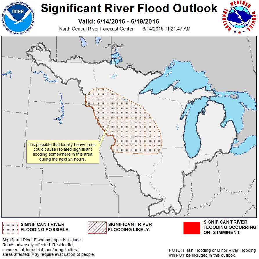
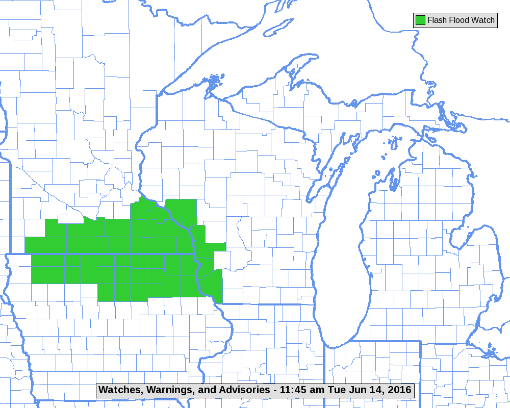
| Flood Outlook for June 14th | Flash Flood Watch for June 14th (Map courtesy of NWS Green Bay) |
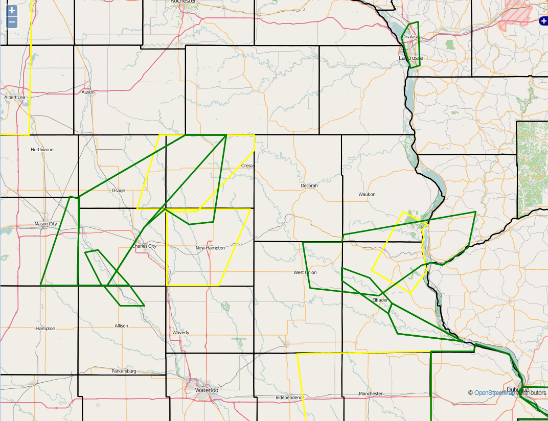
Warnings issued on June 14th (Green is Flash Flood and Yellow is Severe Thunderstorm) |
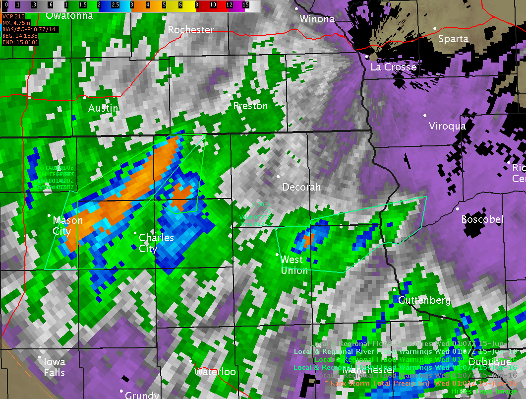
Warnings (green lines) overlaid with rainfall estimations. Notice how we can narrow the warned area using these estimations. |
 |
Media use of NWS Web News Stories is encouraged! Please acknowledge the NWS as the source of any news information accessed from this site. |
|


 Weather Story
 Weather Map
 Local Radar